
VISION OF COUNCIL
"A thriving and friendly community
that recognises our history and embraces cultural diversity and economic
opportunity, whilst nurturing our unique natural and built environment."
AGENDA
FOR THE
Ordinary Meeting of Council
28 July 2016
"A
thriving and friendly community that recognises our history and embraces cultural
diversity and economic opportunity, whilst nurturing our unique natural and
built environment."
OUR MISSION
“To
deliver affordable and quality Local Government services.”
CORE
VALUES OF THE SHIRE
The core
values that underpin the achievement of the
mission
will be based on a strong customer service
focus and a
positive attitude:
Communication
Integrity
Respect
Innovation
Transparency
Courtesy
DISCLAIMER
The purpose of Council Meetings is to discuss, and where possible,
make resolutions about items appearing on the agenda. Whilst Council has
the power to resolve such items and may in fact, appear to have done so at the
meeting, no person should rely on or act on the basis of such decision or on
any advice or information provided by a Member or Officer, or on the content of
any discussion occurring, during the course of the meeting.
Persons should be aware that the provisions of the Local
Government Act 1995 (Section 5.25 (e)) establish procedures for revocation or
rescission of a Council decision. No person should rely on the decisions
made by Council until formal advice of the Council decision is received by that
person. The Shire of Broome expressly disclaims liability for any loss or
damage suffered by any person as a result of relying on or acting on the basis
of any resolution of Council, or any advice or information provided by a Member
or Officer, or the content of any discussion occurring, during the course of
the Council meeting.
Agenda
– Ordinary Meeting of Council 28 July 2016 Page
3 of 6
|
Councillor
|
Cr R Johnston
|
Cr H Tracey
|
Cr M Fairborn
|
Cr W Fryer
|
Cr E Foy
|
Cr D Male
|
Cr P Matsumoto
|
Cr C MIthcell
|
Cr B Rudeforth
|
|
2015
|
26 November
|
|
|
|
|
|
|
LOA
|
|
|
|
2015
|
17 December
|
|
|
|
|
|
|
|
|
|
|
2016
|
25 February
|
|
|
|
|
A
|
|
|
|
|
|
2016
|
31 March
|
|
|
|
|
LOA
|
|
|
|
|
|
2016
|
28 April
|
|
LOA
|
A
|
LOA
|
LOA
|
|
|
|
|
|
2016
|
26 May
|
|
|
A
|
|
|
|
LOA
|
|
|
|
2016
|
30 June
|
|
LOA
|
|
|
|
|
|
|
LOA
|
|
·
LOA
(Leave of Absence)
|
·
NA
(Non Attendance)
|
|
·
A
(Apologies)
|
|
2.25. Disqualification
for failure to attend meetings
(1) A
council may, by resolution, grant leave of absence, to a member.
(2) Leave
is not to be granted to a member in respect of more than 6 consecutive ordinary
meetings of the council without the approval of the Minister, unless all
of the meetings are within a period of 3 months.
(3A) Leave
is not to be granted in respect of —
(a) a
meeting that has concluded; or
(b) the
part of a meeting before the granting of leave.
(3) The
granting of the leave, or refusal to grant the leave and reasons for
that refusal, is to be recorded in the
minutes of the meeting.
(4) A
member who is absent, without obtaining leave of the council, throughout 3
consecutive ordinary meetings of the council is disqualified from continuing
his or her membership of the council, unless all of the meetings are
within a 2 month period.
(5A) If
a council holds 3 or more ordinary meetings within a 2 month period, and a
member is absent without leave throughout each of those meetings, the member is
disqualified if he or she is absent without leave throughout the ordinary
meeting of the council immediately following the end of that period.
(5) The
non‑attendance of a member at the time and place appointed for an
ordinary meeting of the council does not constitute absence from an ordinary
meeting of the council —
(a) if
no meeting of the council at which a quorum is present is actually held on that
day; or
(b) if
the non‑attendance occurs —
(i) while
the member has ceased to act as a member after written notice has been given to
the member under section 2.27(3) and before written notice has been given to
the member under section 2.27(5); or
(ii) while
proceedings in connection with the disqualification of the member have been
commenced and are pending; or
(iiia) while
the member is suspended under section 5.117(1)(a)(iv); or
(iii) while
the election of the member is disputed and proceedings relating to the disputed
election have been commenced and are pending.
(6) A
member who before the commencement of the Local
Government Amendment Act 2009 section 5 1 was granted
leave during an ordinary meeting of the council from which the member was
absent is to be taken to have first obtained leave for the remainder of that
meeting.
[Section
2.25 amended by No. 49 of 2004 s. 19(1); No. 17 of 2009 s. 5.]
Agenda – Ordinary
Meeting of Council 28 July 2016 Page 7 of 8
NOTICE OF MEETING
Dear Council Member,
The next Ordinary Meeting of the
Shire of Broome will be held on Thursday, 28 July 2016 in the Council Chambers,
Corner Weld and Haas Streets, Broome, commencing at 5.00pm.
Regards

K R DONOHOE
Chief Executive Officer
21/07/2016
Agenda –
Ordinary Meeting of Council 28 July 2016 Page 8 of 9
Attendance:
Leave
of Absence:
Apologies:
Officers:
Public
Gallery:
|
FINANCIAL
INTEREST
|
|
Councillor
|
Item
No
|
Item
|
Nature
of Interest
|
|
|
|
|
|
|
IMPARTIALITY
|
|
Councillor
|
Item
No
|
Item
|
Nature
of Interest
|
|
|
|
|
|
|
Recommendation:
That the Minutes of the
Ordinary Meeting of Council held on 30 June 2016 be confirmed as a true and
accurate record of that meeting.
|
The Chief Executive Officer
advises that there are matters for discussion on the agenda for which the
meeting may be closed, in accordance with section 5.23(2) of the Local
Government Act 1995.
|
Recommendation
That the following Agenda items be considered under 14.
Matters Behind Closed Doors, in accordance with section 5.23(2) of the Local
Government Act 1995, as specified:
9.4.6 OBJECTION
TO THE RATE RECORD - NON-RATEABLE LAND UNDER SECTION 6.26(2)(g) - RATE
EXEMPTION APPLICATION 2015/2016 - KIMBERLEY LAND COUNCIL ABORIGINAL
CORPORATION
Item 9.4.6
and any attachments are confidential in accordance with Section 5.23(2) of
the Local Government Act 1995 section 5.23(2)((e)(iii)) as it contains “a
matter that if disclosed, would reveal information about the business,
professional, commercial or financial affairs of a person, where the
information is held by, or is about, a person other than the local government”,
and section 5.23(2)(d) as it contains “legal advice obtained, or which
may be obtained, by the local government and which relates to a matter to be
discussed at the meeting”.
|
9.1
Our People
PRIORITY STATEMENT
Embracing our cultural diversity and the relationship between
our unique heritage and people, we aim to work in partnership with the
community to provide relevant, quality services and infrastructure that meet
the needs and aspirations of our community and those visiting and doing
business in our region.
Supporting and contributing to the well-being and
safety of our community is paramount, as is our focus on community engagement
and participation.
Council aims to build safe, strong and resilient
communities with access to services, infrastructure and opportunities that will
result in an increase in active civic participation, a reduction in anti-social
behaviour and improved social cohesion.
|
9.1.1 REVIEW OF THE ARTS
CULTURE AND HERITAGE ADVISORY COMMITTEE OF COUNCIL
LOCATION/ADDRESS: N/A
APPLICANT: N/A
FILE: RCS12
AUTHOR: Manager
Community Development
CONTRIBUTOR/S: Nil
RESPONSIBLE
OFFICER: Deputy
Chief Executive Officer/Director Community & Economic Development
DISCLOSURE
OF INTEREST: Nil
DATE OF REPORT: 6
July 2016
|
|
SUMMARY: Following
a request from Council and a subsequent workshop, this report presents a
review of the purpose, membership and costs associated with the Arts, Culture
and Heritage Advisory Committee and presents options for Council’s
consideration.
|
BACKGROUND
Previous
Considerations
OMC 6 September 2012 Item
9.1.2
OMC 1 November 2012 Item
9.1.2
OMC 21 November 2013 Item
9.4.6
OMC 2 June 2015 Item
9.1.1
OMC 25 June 2015 Item
9.1.1
OMC 26 November 2015 Item
9.4.5
At the Ordinary Meeting of Council
held on 26 November 2015, Council considered its representation on various
Council Committees, working groups and external committees. At this
meeting, it was resolved;
That Council not appoint
members to the Arts, Culture and Heritage Committee at this time and request
the Chief Executive Officer to undertake a review of Committee costs and
objectives and report back to Council in March 2016.
At its March planning weekend,
Council also requested a workshop to consider Local Planning Policy 8.20
Provision of Public Art. This was held on 28 June 2016 where there was
discussion regarding the policy content and its implementation. Officers
presented the Guidelines for Developers as part of this workshop and received
feedback from Council. The policy content of LPP 8.20 is the subject of a
separate report contained in this agenda.
This report presents an outline of
the activities of the Arts, Culture and Heritage Advisory Committee since its
inception, the costs associated with its operation and some options for
Council’s consideration.
The report also provides some
comment on the implementation of LPP 8.20 subject to Council’s
determination regarding options provided.
COMMENT
Background
The Arts, Culture and Heritage
Advisory Committee (ACHAC) was established by Council in September 2012 for the
purpose of providing advice to Council on matters relating to arts, culture and
heritage. It was recognised that arts, culture and heritage contribute
significantly to Broome’s vibrancy as a place to live, work and visit and
in order for the Shire to make informed decisions relating to such matters, the
advice of community members with specific skills in these areas was
sought.
Since its establishment, the ACHAC
has considered and made recommendations to Council regarding the following;
|
Broome
Civic Centre
|
- Operational
Plan development and review
- Programming
Policy
- Logo
development
- Annual
program review
|
|
Shinju
Matsuri
|
- Sponsorship
Memorandum of Understanding
- Annual
review of Festival outcomes against the Shire’s sponsorship objectives
- Financial
viability and overdraft renewal
|
|
Heritage
|
- Sam
Male & DMcD Luggers national registration
- Shire
of Broome Municipal Heritage Inventory
- Heritage
Signage Project
- MOU
with the WA Museum
- MOU
with the Broome Historical Society
- Streeters
Jetty project
|
|
Public
Art
|
- Public
Art Master Plan development and community consultation
- Public
Art Policy 5.1.6 review
- Local
Planning Policy 8.20 establishment and review
- Establishment
of a Public Art Reserve
- Public
Art Guidelines
- Guidelines
for Developers
- Community
capacity building workshops
|
|
General
|
- Shire
arts and culture objectives
- Arts,
Culture and Heritage Plan
- Christmas
in Chinatown
|
Public Art
At the OMC held 26 February 2015, it
was resolved:
That Council:
1. Adopts the
Public Art Masterplan as attached as a guide for public art initiatives in
Broome; and
2. Notes that to
facilitate the implementation of the Public Art Masterplan the Chief Executive
Officer will review the policies relating to Public Art and present these to
the Committee for recommendation to Council.
3. Requests the Chief
Executive Officer to consider the installation of a public artwork as part of
any development initiatives in Chinatown in the first instance.
Following
this resolution, Officers developed a number of documents to guide the
implementation of Local Planning Policy 8.20 which requires significant
developments to contribute to public art, and Policy 5.1.6 Public Art which
outlines Council’s commitment to increasing the amenity of the town
through public art. These documents also guide the use of the funds held
in the Shire’s Public Art Reserve and the process for ensuring high
quality outcomes, including reference to the Arts Culture and Heritage Advisory
Committee providing advice to Council regarding public art projects.
Chinatown Revitalisation
In 2014,
following extensive public feedback, Council adopted the Chinatown
Development Strategy resolving that Council;
3. Authorises the Chief
Executive Officer to incorporate actions into the 10 year financial plan
for future budget considerations, noting that all recommended actions
are subject to detailed business case, budget and/or grant application considerations.
4. Requests the CEO to
attempt to source grant and other funding to assist with the implementation
of the strategy as soon as possible.
The Strategy, containing several
references to public art, heritage interpretation and place activation, was
used as the basis for the Chinatown Revitalisation Business Case submitted to
the State Government to support an investment by the State of $10
million. Several projects included in the Business Case relate to matters
of arts, culture and heritage where the advice of the Arts, Culture and
Heritage Advisory Committee was anticipated to be sought for recommendation to
Council. These include (but may not be limited to);
- Chinatown
Waterfront – interpretation of pearling sheds, activation
- Cultural
Centre – culture and heritage interpretation, art and cultural
exhibitions
- Street
upgrades – public art, functional art, way-finding, rest facilities
- Enhanced
laneways – eg community mural projects
- Chinatown
Entry Statements
Proposed Options
Officers propose the following three
options for Council’s consideration.
Option 1:
Officer Recommendation (preferred option)
That Council re-appoint members to
the Arts, Culture and Heritage Advisory Committee and endorse the Terms of
Reference as attached to this report;
This option proposes that
the ACHAC continues to consider and provide advice to Council on matters
relating to arts, culture and heritage.
The original reason for
establishing the Arts, Culture and Heritage Advisory Committee was to recognise
the specialist nature of some of the matters to be considered and to seek
expert advice on these matters. In addition, given the prevalence of
arts, cultural and heritage activity in Broome, seeking advice and feedback from
community members was considered sound community engagement practise. Should
Council choose to re-appoint members to the ACHAC, the committee is envisaged
to have a significant role in advising Council on ongoing implementation of the
Local Planning Policy 8.20, use of funds currently held in the Shire’s
Public Art Reserve and implementation of arts culture and heritage projects
within the Chinatown Revitalisation project.
|
Benefits
|
Risks
|
Rating
|
|
- Formal committee of Council
requires structured agenda, officer reports and minutes
- Transparent process available
for community information
- Specialist advice provided to
Council ensuring a quality outcome and decreased risk of community
dissatisfaction
|
- Staff time to prepare and
distribute papers
- Council disagrees with
Committee recommendations
|
High
Moderate
|
Option 2
Requests the Chief Executive
Officer to establish an informal working group for the purpose of providing
input and feedback on matters relating to arts, culture and heritage within the
Shire of Broome:
This is a less formal means
of consultation with community members but still provides a mandate to officers
to seek advice from working group members to inform recommendations to
Council. Council could choose to amend the purpose of the working group
so that the group provides advice on matters of a specific nature (eg. public
art submissions).
It should be noted that a
reduction in staff time to prepare papers for a working group rather than a
formal Committee of Council may be negated by an increase in staff time to
prepare papers for Council meetings as matters that may have been considered by
the ACHAC may be referred directly to Council for consideration.
|
Benefits
|
Risks
|
Rating
|
|
- Less time commitment for
members and staff and therefore less cost to the organisation
- Specialist advice provided to
Officers for recommendation to Council increasing likelihood of a quality
outcome and decreased risk of community dissatisfaction
|
- Community dissatisfaction with
the process for decision making
- Potential misinterpretation of
working group advice
- Perception of lack of regard
for community input into matters relating to arts, culture and heritage
- Limited ability to manage
conflicts of interest
|
High
Low
Moderate
High
|
Option 3:
Chooses not to re-establish
the Arts, Culture and Heritage Advisory Committee of Council and:
1. Requests that all
decisions relating to arts, culture and heritage matters are submitted directly
to Council for consideration;
2. Notes that Council
may choose to seek public comment on arts, culture and heritage matters at its
discretion;
3. Requests the Chief
Executive Officer to amend the Guidelines for Developers and Guidelines for
Public Art to reflect Council’s decision.
This means that Council would be
required to make decisions relating to arts, culture and heritage without
expert advice sought from relevant community members. This increases the
risk of community opposition to decisions or, should Council choose to go to
open engagement for arts, culture and heritage projects, means that project
timelines will be lengthened and possibly stalled.
|
Benefits
|
Risks
|
Rating
|
|
- No time commitment for members
and staff and therefore less cost to the organisation
- Whole of community engagement
process
|
- Community dissatisfaction with
the process for decision making
- No specialist advice provided
and potential lack of quality outcome
- Conflicting feedback from
community engagement process resulting in delayed decision making
- Community dissatisfaction with
outcome
- Perception of lack of regard
for community input into matters relating to arts, culture and heritage
|
High
High
Extreme
High
High
|
Officers recommend that,
given there are a number of planned projects requiring artistic, cultural or
heritage consideration and specialist advice, members are re-appointed to the
ACHAC as per Option 1 outlined above.
Officers recommend that
Council reappoint members to the ACHAC rather than establish the group as an
informal working group as past experience indicates this will achieve better
outcomes. The Access and Inclusion Advisory Committee was transitioned from a
working group to a formal committee of Council in late 2013, since this time
the Committee has generated more tangible outcomes, meetings have been more
efficient and effective and recommendations to Council have been clear and
outcomes focussed.
CONSULTATION
|
Shire of Kalamunda
|
City of Karratha
|
|
Town of Port Hedland
|
City of Melville
|
|
WA Department of Culture and the
Arts
|
Chamber of Arts and Culture
|
|
W.A.R.C.A.
|
|
STATUTORY ENVIRONMENT
Local Government Act 1995
Division 2 – Council meetings, committees and their
meetings and electors’ meetings
Subdivision 2 — Committees
and their meetings
5.8. Establishment
of committees
A local
government may establish* committees of 3 or more persons to assist the council
and to exercise the powers and discharge the duties of the local government
that can be delegated to committees.
* Absolute majority required.
5.9. Committees,
types of
(1) In
this section —
other
person means a person who is not a council member or an employee.
(2) A
committee is to comprise —
(a) council
members only; or
(b) council
members and employees; or
(c) council
members, employees and other persons; or
(d) council
members and other persons; or
(e) employees
and other persons; or
(f) other
persons only.
5.10. Committee
members, appointment of
(1) A
committee is to have as its members —
(a) persons
appointed* by the local government to be members of the committee (other than
those referred to in paragraph (b)); and
(b) persons
who are appointed to be members of the committee under subsection (4) or
(5).
*
Absolute majority required.
(2) At any
given time each council member is entitled to be a member of at least one
committee referred to in section 5.9(2)(a) or (b) and if a council member
nominates himself or herself to be a member of such a committee or committees,
the local government is to include that council member in the persons appointed
under subsection (1)(a) to at least one of those committees as the local
government decides.
(3) Section 52
of the Interpretation Act 1984 applies to appointments of committee
members other than those appointed under subsection (4) or (5) but any
power exercised under section 52(1) of that Act can only be exercised on
the decision of an absolute majority of the local government.
(4) If at a
meeting of the council a local government is to make an appointment to a
committee that has or could have a council member as a member and the mayor or
president informs the local government of his or her wish to be a member of the
committee, the local government is to appoint the mayor or president to be a
member of the committee.
(5) If at a
meeting of the council a local government is to make an appointment to a
committee that has or will have an employee as a member and the CEO informs the
local government of his or her wish —
(a) to
be a member of the committee; or
(b) that
a representative of the CEO be a member of the committee,
the local
government is to appoint the CEO or the CEO’s representative, as the case
may be, to be a member of the committee.
5.11A. Deputy
committee members
(1) The
local government may appoint* a person to be a deputy of a member of a
committee and may terminate such an appointment* at any time.
* Absolute majority required.
(2) A
person who is appointed as a deputy of a member of a committee is to
be —
(a) if
the member of the committee is a council member — a council member;
or
(b) if
the member of the committee is an employee — an employee; or
(c) if
the member of the committee is not a council member or an employee —
a person who is not a council member or an employee; or
(d) if
the member of the committee is a person appointed under
section 5.10(5) — a person nominated by the CEO.
(3) A deputy of a member of a committee may perform
the functions of the member when the member is unable to do so by reason of
illness, absence or other cause.
(4) A deputy of a member of a committee, while acting
as a member, has all the functions of and all the protection given to a member.
[Section 5.11A inserted by No. 17 of 2009 s. 20.]
5.11. Committee membership,
tenure of
(1) Where a
person is appointed as a member of a committee under section 5.10(4) or
(5), the person’s membership of the committee continues
until —
(a) the
person no longer holds the office by virtue of which the person became a member,
or is no longer the CEO, or the CEO’s representative, as the case may be;
or
(b) the
person resigns from membership of the committee; or
(c) the
committee is disbanded; or
(d) the
next ordinary elections day,
whichever
happens first.
(2) Where a
person is appointed as a member of a committee other than under
section 5.10(4) or (5), the person’s membership of the committee
continues until —
(a) the
term of the person’s appointment as a committee member expires; or
(b) the
local government removes the person from the office of committee member or the
office of committee member otherwise becomes vacant; or
(c) the
committee is disbanded; or
(d) the
next ordinary elections day,
whichever
happens first.
POLICY IMPLICATIONS
Policy 5.1.2 Broome
History Collection
Policy 5.1.9 Shire
of Broome Shinju Matsuri Acquisitive Art Prize
Policy 5.1.6 Public
Art
Policy 5.1.12 Broome
Civic Centre Programming
LPP 8.6 Municipal
Heritage Inventory
LPP 8.20 Provision
of Public Art
FINANCIAL IMPLICATIONS
Resource Implications
The current terms of reference (TOR)
for the Arts, Culture and Heritage Advisory Committee include the following
membership representatives:
3 x Councillors
1 x Heritage organisation
1 x Arts organisation
1 x Cultural organisation
4 x Community representatives (at
least one with public art experience)
The TOR provide for quarterly
meetings which are publicly advertised, and a formal agenda with agenda reports
included is distributed prior to the meeting. The Committee makes recommendations
to Council which are then compiled into formal minutes of the meeting.
The minutes and the recommendations are considered at the next Ordinary Meeting
of Council.
The resource implications for this
committee (per meeting) are outlined below.
|
Item
|
Councillors (in-kind)
|
Officers
|
Community Members (in-kind)
|
Comment
|
|
Meeting preparation
|
4.5 hours
|
18 hours
|
10.5 hours
|
1.5 hours of reading per member, officer
time to prepare & distribute agenda
|
|
Meeting time
|
6 hours
|
6 hours
|
14 hours
|
2 hours per meeting per person
|
|
Follow-up
|
|
4 hours
|
|
Minutes preparation and proofing
|
|
Incidentals
|
1 hour
|
2 hours
|
1 hour
|
Advertising, phone, printing
|
|
Total time per meeting
|
11.5 hours
|
30 hours
|
25.5 hours
|
|
While Councillor and community member
time is in-kind, Shire staff time is a direct cost to the organisation and is
estimated at approximately $2,200 per meeting including overheads.
Therefore, the annual direct cost to the Shire is $8,800 based on quarterly
meetings.
RISK
As discussed above.
STRATEGIC
IMPLICATIONS
Our People
Goal – Foster a community environment that is accessible, affordable,
inclusive, healthy and safe:
Effective communication
Our Place
Goal – Help to protect the nature and built environment and cultural
heritage of Broome whilst recognising the unique sense of the place:
A preserved, unique and significant
historical and cultural heritage of Broome
Retention and expansion of
Broome’s iconic tourism assets and reputation
Our
Organisation Goal – Continually enhance the Shire’s organisational
capacity to service the needs of a growing community:
An organisational culture that
strives for service excellence
Responsible resource allocation
Effective community engagement
VOTING REQUIREMENTS
Absolute Majority
|
REPORT RECOMMENDATION:
That Council re-appoint members
to the Arts, Culture and Heritage Advisory Committee and endorse the Terms of
Reference as attached to this report.
(Absolute Majority Required)
|
Attachments
|
1.
|
Reviewed Terms of
Reference - ACHAC
|
|
Item 9.1.1 - REVIEW OF THE ARTS CULTURE AND HERITAGE
ADVISORY COMMITTEE OF COUNCIL
|
Arts, Culture and
Heritage Advisory Committee
|
This Committee is currently under
review
At the OMC 26 November 2015,
Council Resolved:
Council
Resolution:
Moved: Cr R Johnston Seconded:
Cr B Rudeforth
That
Council not appoint members to the Arts Culture and Heritage Committee at this
time and request the Chief Executive Officer to undertake a review of Committee
costs and objectives and report back to Council in March 2016.
CARRIED UNANIMOUSLY BY ABSOLUTE MAJORITY
6/0
|
3 x Councillors
(including Deputies)
|
-
|
Cr____________
Cr
___________ (Deputy)
Cr ___________
Cr
___________ (Deputy)
Cr
___________
Cr ___________ (Deputy)
|
|
7x Community Delegates
Chairperson/Deputy
|
-
|
1 x Heritage
Organisation
Sarah
Keenan, Broome Historical Society
1 x Arts
Organisation
Sandy
Darrington – Arts Organisation
1 x Cultural
Organisation
Sarah
Yu, Nyamba Buru Yawuru
4 x Community
Representatives
Eunice
Yu
Vanessa
Margetts
Gwen
Knox
Rani
Middleton
(Chairperson);
(Deputy Chair)
|
|
Officer Responsible
|
-
|
Deputy Chief
Executive Officer/Director Community and Economic
Development
|
|
Standing Ex-Officio Members
|
|
Deputy
Chief Executive Officer/Director Community and Economic Development
Manager
Community Development
|
|
Meeting Schedule
|
-
|
Quarterly and other meetings as
required
|
|
Meeting Location
|
-
|
Function or
Committee Room, Shire of Broome
|
|
Quorum
|
-
|
Five (5) voting members as per
Section 5.19 of the Local Government Act 1995
|
|
Delegated Authority
|
-
|
Nil
|
FUNCTIONS:
The name of the Committee is the Arts,
Culture & Heritage Advisory Committee.
2.0 DISTRICT/AREA OF
CONTROL
Local Government boundaries of the Shire of
Broome.
To provide advice to Council on
matters of Arts, Culture and Heritage. This includes matters relating to the
Shinju Matsuri Festival such as the scope of financial and in kind support
provided to the festival and participation in the Shinju Matsuri Aquisitive
Arts Prize.
To provide advice to Council to
guide the implementation of the Shire of Broome Public Art Policy.
Shire of Broome Standing Orders
Local Law 2003
The Shire of Broome Standing
Orders Local Law 2003 (Amended 30 July 2004 and 31 July 2012) apply.
Shire
of Broome Policies:
Policy
5.1.6 Public Art
Policy
5.1.9 Shinju Matsuri Acquisitive Art Prize
Various
legislative instruments may apply including but not limited to:
Heritage
of Western Australia Act 1990
Aboriginal
Heritage Act 1972
Museum Act 1969
Copyright
Act 1968
Copyright
Amendment (Moral Rights) Act 2000
Established by
Council Resolution on 6 September 2012.
1. Research
and develop a draft Arts & Culture Plan for consideration by Council
2. Research
and develop a draft Cultural Heritage Plan for consideration by Council
1. Provide advice to Council on matters relating
to the Shinju Matsuri Festival such as;
a. the scope of financial and in kind support
provided to the festival; and
b. participation in the Shinju Matsuri
Acquisitive Art Prize.
2. Provide advice to
Council to guide the implementation of the Shire of Broome Public Art Policy
and Local Planning Policy 8.20 and to make recommendations to Council relating
to public art regarding the:
a. commissioning model to be used for public art
projects;
b. selection of artist(s);
c. approval of concepts and design.
3. Provide
input and advice regarding the allocation of funds for arts, culture and
heritage activities for the Shire’s annual budget process.
7.1 General
Council will appoint three elected
members as Delegates and three elected members as Deputies to the Committee. Three
Shire officers are also appointed as members.
7.2 Tenure
of Membership
Where a person is appointed as a
member of the Arts, Culture and Heritage Committee the person’s
membership of the Committee continues until —
· The person no longer holds office by virtue of which the person
became a member.
· The person resigns from membership of the Committee.
· The Committee is disbanded.
· The Council removes the person from the Committee by resolution of
Council.
· For
elected member Delegates, the next ordinary elections day
Officers
may be appointed and removed from the Committee by the Director/s of the
functional area responsible for the Committee.
The Committee does not have executive
powers or authority to implement actions in areas over which the CEO has
legislative responsibility and does not have any delegated financial
responsibility. Unless provision has been made in the Budget for
expenditure, Committees require an officer report to be presented to Council
for endorsement of any proposed expenditure.
9.1 Chairperson
The Chairperson and Deputy
Chairperson to be elected by the Committee members. The Chairperson is
_________ and the Deputy Chairperson is __________.
The role of
Chairperson and Deputy Chairperson are to be vacated following biannual Council
elections in October and re-elected from the Committee membership.
9.2 Secretariat
This role is to be fulfilled by a
Shire officer from the Community Development Directorate.
9.3 Standing
Ex-Officio Members
Shire President and Chief
Executive Officer.
Deputy Chief
Executive Officer/Director Community and Economic Development, Manager
Community Development or their delegate(s) will be standing ex-officio
members. Other officers or community members may be invited to attend
meetings as required and to be determined by the Chief Executive Officer.
10.1 Annual
General Meeting
N/A
10.2 Committee
Meetings
The Chairperson
Chief Executive Officer will call meetings every
three months and as required.
Committee meetings will be advertised
as per statutory requirements.
10.3 Quorum
Five members
including one elected member delegate.
10.4 Voting
Voting shall be by consensus or by a
show of hands as directed by the Chairperson. If voting is enacted it
will follow principles of S5.21 of the Local Government Act 1995.
Local Government
Act 1995
S 5.21 - Voting
(1) Each
council member and each member of a committee who is present at a meeting of
the council or committee is entitled to one vote.
(2) Subject
to section 5.67, each council member and each member of a committee to which a
local government power or duty has been delegated who is present at a meeting
of the council or committee is to vote.
(3) If
the votes of members present at a council or a committee meeting are equally
divided, the person presiding is to cast a second vote.
(4) If a
member of a council or a committee specifically requests that there be recorded
—
(a) his
or her vote; or
(b) the
vote of all members present, on a matter voted on at a meeting of the council
or the committee, the person presiding is to cause the vote or votes, as the
case may be, to be recorded in the minutes.
10.5
Minutes of Meetings
The person presiding is to ensure
that Minutes of the Meeting are kept of the meetings proceedings.
The Meeting Minutes may be confirmed
by a majority of members present at the meeting in writing via email, after the
completion of the meeting. Once Meeting Minutes have been confirmed by
members they are to be submitted to the Council Secretary be posted on
the Shire’s website.
Recommendations requiring Council
action arising from the Meeting Minutes shall be presented to Council at the
next Ordinary Council Meeting or earliest available Council meeting if it is
not possible to present the Minutes to the next Ordinary Council Meeting.
10.6 Who
Acts if No Presiding Member
If, in relation
to the presiding member of the Committee:
(a) the
office of presiding member and the office of deputy presiding member are
vacant; or
(b) the
presiding member and the deputy presiding member, if any, are not available or
are unable or unwilling to perform the functions of presiding member, then the
Committee members present at the meeting are to choose one of themselves to
preside at the meeting.
10.7
Members Interests to be Disclosed
Members of the Arts, Culture &
Heritage Committee are required to declare their financial interests and
complete a Declaration form where relevant, using the principles detailed in the Local Government Act Section 5.65-5.70 with respect to
disclosure of financial, impartiality or proximity interests (‘CEO’
in the LGA text means the ‘Chairperson’ in the committee sense).
5.65.
Members’ interests in matters to be discussed at meetings to be disclosed
(1) A
member who has an interest in any matter to be discussed at a council or
committee meeting that will be attended by the member must disclose the nature
of the interest —
(a) in
a written notice given to the CEO before the meeting; or
(b) at
the meeting immediately before the matter is discussed.
Penalty: $10 000 or
imprisonment for 2 years.
(2) It
is a defence to a prosecution under this section if the member proves that he
or she did not know —
(a) that
he or she had an interest in the matter; or
(b) that
the matter in which he or she had an interest would be discussed at the
meeting.
(3) This
section does not apply to a person who is a member of a committee referred to
in section 5.9(2)(f).
5.9. Types of committees
(1) In
this section — “other person”
means a person who is not a council member or an employee.
(2) A
committee is to comprise —
(f) other
persons only.
5.66. Meeting
to be informed of disclosures
If a member has disclosed an
interest in a written notice given to the CEO before a meeting then —
(a) before
the meeting the CEO is to cause the notice to be given to the person who is to
preside at the meeting; and
(b) at
the meeting the person presiding is to bring the notice and its contents to the
attention of the persons present immediately before the matters to which the
disclosure relates are discussed.
[Section
5.66 amended by No.1 of 1998 s.16; No. 64 of 1998 s.33.]
5.67. Disclosing
members not to participate in meetings
A member who makes a disclosure
under section 5.65 must not —
(a) preside
at the part of the meeting relating to the matter; or
(b) participate in, or be present
during, any discussion or decision making procedure relating to the matter,
unless, and to the extent that, the disclosing member is allowed to do so under
section 5.68 or 5.69.
Penalty: $10 000 or
imprisonment for 2 years.
5.68. Councils
and committees may allow members disclosing interests to participate etc. in
meetings
(1) If
a member has disclosed, under section 5.65, an interest in a matter, the
members present at the meeting who are entitled to vote on the
matter —
(a) may
allow the disclosing member to be present during any discussion or decision
making procedure relating to the matter; and
(b) may
allow, to the extent decided by those members, the disclosing member to preside
at the meeting (if otherwise qualified to preside) or to participate in
discussions and the decision making procedures relating to the matter
if —
(i) the
disclosing member also discloses the extent of the interest; and
(ii) those
members decide that the interest —
(I) is
so trivial or insignificant as to be unlikely to influence the disclosing
member’s conduct in relation to the matter; or
(II) is
common to a significant number of electors or ratepayers.
(2) A
decision under this section is to be recorded in the minutes of the meeting
relating to the matter together with the extent of any participation allowed by
the council or committee.
(3) This
section does not prevent the disclosing member from discussing, or
participating in the decision making process on, the question of whether an
application should be made to the Minister under section 5.69.
5.70. Employees
to disclose interests relating to advice or reports
(1) In
this section —
employee includes a person who, under a contract for
services with the local government, provides advice or a report on a matter.
(2) An
employee who has an interest in any matter in respect of which the employee is
providing advice or a report directly to the council or a committee must
disclose the nature of the interest when giving the advice or report.
(3) An
employee who discloses an interest under this section must, if required to do
so by the council or committee, as the case may be, disclose the extent of the
interest.
Penalty:
$10 000 or imprisonment for 2 years.
5.71. Employees
to disclose interests relating to delegated functions
If, under Division 4, an
employee has been delegated a power or duty relating to a matter and the
employee has an interest in the matter, the employee must not exercise the
power or discharge the duty and —
(a) in
the case of the CEO, must disclose to the mayor or president the nature of the
interest as soon as practicable after becoming aware that he or she has the
interest in the matter; and
(b) in
the case of any other employee, must disclose to the CEO the nature of the
interest as soon as practicable after becoming aware that he or she has the
interest in the matter.
Penalty: $10
000 or imprisonment for 2 years.
|
9.1.2 TRADING IN PUBLIC PLACES
POLICY
LOCATION/ADDRESS: Nil
APPLICANT: Nil
FILE: LAW016
AUTHOR: Director
Development Services
CONTRIBUTOR/S: Nil
RESPONSIBLE
OFFICER: Director
Development Services
DISCLOSURE
OF INTEREST: Nil
DATE OF REPORT: 28
June 2016
|
|
SUMMARY: Shire
of Broome Policies 4.2.12 Trading in Public Places, 4.5.1 Commercial Camel
Activities on Cable Beach and 4.5.3 Commercial Activities on Cable Beach all
regulate activities undertaken with a trading licence obtained in accordance
with the Trading, Outdoor Dining and Street Entertainment Local Law
2003. These policies have been reviewed to ensure they are reasonable
and appropriate in facilitating the issuing of trading licences in the
Shire.
As a result of the review, a single Trading in Public Places
policy has been developed incorporating necessary and relevant provisions
from all three policies. The new proposed policy incorporates changes
made to assist with interpretation and administration of the policy and
provide greater flexibility for trading licences to be granted.
The purpose of this report is to seek Council’s
endorsement of the draft policy for it to be released for targeted
stakeholder and broader public consultation.
|
BACKGROUND
Previous
Considerations
Policy 4.2.12 – Trading in Public
Places
OMC 2 August 2010 Item
9.3.2
OMC 15 December 2010 Item
9.3.10
OMC 15 March 2012 Item
9.4.5
OMC 27 March 2014 Item
9.4.5
OMC 17 December 2015 Item
9.4.3
Policy 4.5.1 – Commercial
Camel Activities on Cable Beach
OMC 14 February 2008 Item
9.2.1
OMC 19 March 2009 Item
9.1.3
OMC 20 June 2013 Item
9.2.9
OMC 27 March 2014 Item
9.4.5
OMC 17 December 2015 Item
9.4.3
Policy 4.5.3 – Commercial
Activities on Cable Beach
OMC 14 February 2008 Item
9.2.1
OMC 19 March 2009 Item
9.1.3
OMC 27 March 2014 Item
9.4.5
OMC 17 December 2015 Item
9.4.3
At the December 2010 Ordinary Meeting
of Council (OMC) a resolution to adopt the Trading in Public Places
Policy (Trading Policy) was passed. The need for a trading policy
to support the Trading, Outdoor Dining and Street Entertainment Local Law (Trading
Local Law) arose due to concerns raised about the appropriateness of a
trading activity occurring at the Broome Cemetery. The Trading Policy was
reviewed but left unchanged at the OMC on 15 March 2012 and 27 March
2014. The Trading Policy was reviewed with only an officer’s
position title amended at the 17 December 2015 OMC. It was also noted at
the 17 December 2015 OMC that the Trading Policy required further review.
At the OMC on
21 December 2006, Council resolved to rescind the Commercial and Tourism
Activities on Cable Beach Policy due to a State Administrative Tribunal (SAT)
ruling in relation to a provision of the policy applying to the setting of
fees. As a result, Council Officers developed two new policies, the
Commercial Camel Activities on Cable Beach Policy (Camel Policy) and the
Commercial Activities on Cable Beach Policy (Cable Beach Policy), which
were adopted by Council at its February 2008 OMC.
The Camel
Policy was reviewed but left unchanged at the OMC on 19 March 2009 and 27 March
2014. The Camel Policy was reviewed and amended at the OMC on 20 June
2013 to update the policy prior to the expiry of the existing trading licences
for the commercial camel activities at that time. The Camel Policy was
reviewed and amended to increase the number of camels each licensee can have on
the beach at any one time from 16 to 18 at the 17 December 2015 OMC. It
was also noted at the 17 December 2015 OMC that the Camel Policy required a
further full review.
The Cable
Beach Policy was reviewed but left unchanged at the OMC on 19 March 2009 and 27
March 2014. At the 17 December 2015 OMC it was noted that the Cable Beach
Policy was undergoing a separate review, with the results of this review to be
presented to Council if amendments were considered to be required.
COMMENT
Council Officers have undertaken a
review of Council Policies 4.2.12 Trading in Public Places (Trading Policy),
4.5.1 Commercial Camel Activities on Cable Beach (Camel Policy) and
4.5.3 Commercial Activities on Cable Beach (Cable Beach Policy).
The purpose of this review was to identify the effectiveness and
appropriateness of these policies.
These policies all support the
operation of the Trading, Outdoor Dining and Street Entertainment Local Law
2003 (Trading Local Law) by providing additional information and
controls in relation to the issuing of trading licences under the Trading Local
Law. Therefore, the review of these policies was undertaken concurrently
with the review of the Trading Local Law.
Officers were aware that the
provisions of the policies, and in particular the Trading Policy and the Cable
Beach Policy, were difficult to administer, inflexible, presented a barrier to
new trading activities being considered and were somewhat out of date.
Overall, Officers have found the policies to be unnecessarily restrictive,
discouraging of innovation and preventing activities that could activate and
add vibrancy to public spaces. Therefore, the review sought to address
these issues, while still allowing for sufficient regulatory control and
oversight of trading activities.
There was a significant amount of
overlap between the three policies also identified. It is for that reason
that it is proposed that all three policies be replaced with a single Trading
in Public Places policy (new Policy), which includes provisions specific
to commercial activities on Cable Beach and commercial camel activities in
Schedules 1 and 2 of the new Policy. The new Policy is included as Attachment
1 to this report.
The issues that were identified for
each policy as part of the review and the changes proposed through the new
Policy are outlined below.
Policy 4.2.12 Trading in Public
Places
Objective
The objectives of the Trading Policy
are as follows:
1. To
facilitate approval of Trading Licences using public places, as defined below,
and therefore reducing administrative matters being placed on Council.
2. To
protect existing levels of public amenity and safety from the impact of trading
activities by adequately addressing potential risk management issues.
3. Maintain
equity in the regulation of trading in public places by promoting fairness and
certainty to traders and the community.
4. Protect
the financial interest of ratepayers through appropriate management of traders
in public places and support development of local small business within the
Shire of Broome.
In reviewing these objectives,
Officers considered that they could be modified to be more positive and look at
what should be encouraged rather than discouraged. Therefore, it is
recommended that these objectives be replaced with the following:
1. To
facilitate the assessment and approval of Trading Licences in accordance with
the Trading, Outdoor Dining and Street Entertainment Local Law 2003.
2. To
maintain amenity, usability and public safety in public places.
3. Promote
fairness and certainty to traders, permanent businesses and the community in
relation to trading in public places.
4. Promote
vibrancy of public places and economic development in the Shire of Broome.
Definitions
Officers considered that some
additional definitions could be added to assist in the interpretation of the
new Policy and to align the new Policy better with the Trading Local Law.
Note that some of the definitions will need to be amended if and when the
proposed amendments to the Trading Local Law take effect.
Policy
The policy provisions in the Trading
Policy are lengthy and in some circumstances unnecessarily restrictive.
To assist in the interpretation of
the new Policy, its provisions have been refined to assist in interpretation
and split into the following categories:
· Criteria
which must be met for a trading licence to be issued;
· Conditions
that will be imposed on a trading licence;
· Things that
cannot form part of a trading activity; and
· Obligations
on the holder of a trading licence.
Additional provisions have been
retained or added as follows:
· Shire
Officers may seek additional information from an applicant to facilitate the
assessment of an application;
· Ability to
invite applications for trading licences in a particular area or for a
particular type of trading activity (included in the Camel Policy and Cable
Beach Policy);
· Council may
seek public comment on a particular trading licence application if it is
considered desirable to do so in the circumstances;
· An
authorised person may direct the holder of a trading licence to stop doing
something in contravention of the Trading Local Law or trading licence;
· Failure to
comply with the obligations on a trader outlined in the Policy is deemed to be
a breach of the trading licence conditions for the purposes of clause 2.7(a) of
the Trading Local Law;
· The annual
fee payable for a trading licence will be due 1 August annually; and
· Advising
applicants of their right to object to a decision made by the Shire in
accordance with section 9.4 of the Local Government Act 1995 (LG Act).
Also, until such time that proposed
amendments are made to the Trading Local Law, it is recommended that the new
Policy include the following provisions:
· For the
purposes of subclause 5.2.3 of the Trading Local Law, exempting the need for a
trading licence for events and activities otherwise approved by the Shire; and
· For the
purposes of subclause 2.7(f) of the Trading Local Law, the failure of a
licensee to undertake an activity approved by a trading licence for a period of
12 months is considered a ground upon which a trading licence should be
cancelled.
The following changes are proposed in
the new Policy compared with the existing Trading Policy:
· Removal of
need for a supporting statement from a landowner if the activity is on private
land, to reflect that the Trading Local Law is used to regulate trading
activities on public land. Trading activities on private land require
development approval.
· Removal of
specific reference to the need to assess the suitability of the activity using
land, including the Cemetery. This has been replaced with criteria
requiring a trading activity to be consistent with the zoning of the land in
the Planning Scheme, any existing use of the land and any management order for
the land.
· Removal of
the need for only one trading licence for multiple trading activities
comprising an event, as it is proposed that approved events be exempt from the
need for a trading licence.
· Removal of
the restriction on trading within 300m of a permanent business that has for
sale any goods or services of the kind offered for sale by the trader.
The practical application of this provision has meant that the there are very
few places in the town of Broome where a trading licence can be issued.
There are also difficulties in interpreting this provision, in relation to what
“goods or services of the kind offered for sale by the trader”
means and how broadly it should be interpreted.
However, it is still considered
necessary to protect the commercial interests of permanent businesses.
Therefore, this restriction has been replaced with the requirement that a
proposed trading activity does not occur within 300 metres of a permanent
business that it would be directly competing with, unless:
- the
trading activity does not occur during the ordinary opening hours of the
permanent business; or
- the
owners of the permanent business have provided their support in writing for the
proposed trading activity; or
- Council
decides that the proposed trading activity should be approved notwithstanding
its proximity to the permanent business.
To support the interpretation of this
provision, a new definition has been included in the new Policy for
“directly competing with”.
· The
requirement that a trading activity undertaken as part of an event not conflict
with commercial arrangements in place for local government property, including
leases, has been removed given the proposal that approved events be exempt from
the need for a trading licence.
· The
requirement that a trader be removed from the trading area within 15 minutes of
any timeframe approved for the trading activity was removed, as it was
considered unnecessarily restrictive. Any issues such as this can be
appropriately managed through conditions attaching to a trading licence and the
general requirement to make good an area used for a trading licence in the new
Policy and Trading Local Law.
· Removal of
the need for approval from the land owner and existing business if trading is
undertaken in a private car park, as this would be subject to development
approval and not a trading licence.
· The need for
a hard stand area for stationary trading activities has been removed, as this
will not always be required for stationary trading activities.
· Removal of
the restriction on using tables and chairs for a trading activity, as this may
be appropriate in certain circumstances.
· Removing the
statement that a food licence is required, as this is a requirement under the Food
Act 2008 in any event.
· Removing the
need for approval from the event organiser for a trading activity carried out
as part of an event, given the proposal that approved events be exempt from the
need for a trading licence.
· Requirement
for trading not to conflict with Shire lease agreements, as this will be
considered in assessing the suitability of the land and the potential impact on
existing uses.
Policy 4.5.1 Commercial Camel
Activities on Cable Beach
Introduction and Objectives
The introduction to the Camel Policy
contains wordy provisions that are considered to be summarised in the proposed
objective for the new Policy. In addition, the objectives of the Camel
Policy are considered to be adequately summarised in the objective of the new
Policy, which in full is as follows:
1. To
facilitate the assessment and approval of Trading Licences in accordance with
the Trading, Outdoor Dining and Street Entertainment Local Law 2003.
2. To
maintain amenity, usability and public safety in public places.
3. Promote
fairness and certainty to traders, permanent businesses and the community in
relation to trading in public places.
4. Promote
vibrancy of public places and economic development in the Shire of Broome.
5. To
protect Cable Beach as a highly valued environmental, cultural and social asset
enjoyed by visitors and residents alike.
Definitions
Definitions have been included in the
new Policy for terms used in the Camel Policy which are now used in the new
Policy. Because the definition of Related Entity Interest is so detailed,
the content of the definition (outlined in a table) has been included in
Schedule 4 of the new Policy. The definition has been amended slightly to
assist in its interpretation.
Policy
The policy provisions in the Camel
Policy are lengthy and as with the Trading Policy, in some circumstances
unnecessarily restrictive. A number of changes have been made to assist
in the interpretation of the policy provisions, without altering the effect of
the provision.
There was quite a bit of overlap
between the provisions of the Camel Policy and the provisions of the Trading
Policy. These general provisions which overlap have been carried over or
altered in the body of the new Policy as discussed above.
Provisions specific to the commercial
camel activities have been included in Schedule 2 of the new Policy.
Overall, the following changes are
proposed in the new Policy compared with the existing Camel Policy:
· Increase the
maximum number of camels under a single licence to 18 on Cable Beach at any
time, in accordance with the proposed amendments to Schedule 2 of the Local
Government Property and Public Places Local Law 2012 (LGPPP Local Law)
and the SAT determination and mediated outcomes in relation to the commercial
camel licences in 2014.
· Removal of
provisions contained in Schedule 2 of the LGPPP Local Law, with the inclusion
of a provision requiring the operation of any commercial camel activities and
the conditions of any trading licence to be consistent with these provisions.
· Removal of
requirement on the Shire to advertise for applications for commercial camel
activities 6 months before the expiry of existing licences, to provide the
Shire with flexibility in relation to this process.
· Removal of
provisions that overlap or restate provisions in the Trading Local Law.
· Removal of
weighting of the criteria for applications received for trading licences, to
assist in the assessment of applications.
· Removal of
criteria which merely restates the requirements for all trading activities,
included in the body of the new Policy.
· Removal of
the provisions regarding the setting of fees for commercial camel trading
licences, as this is regulated by the LG Act and is administrative detail not
required to be in the new Policy.
· Removal of
the requirement for the approved access route, allocated pick up and set down
area and operating area to be adhered to, as the requirement to comply
with a trading licence is included in the Trading Local Law.
· Removal of
the provisions regarding the transfer of a trading licences and infringement
notices, as these matters are outlined in the Trading Local Law.
· Removal of
the provisions relating to the cancellation or suspension of a trading licence,
as this is outlined in the Trading Local Law. The requirement for the
Shire to allow the trader 14 days to show cause why their licence should not be
revoked has been removed to give the Shire greater flexibility in relation to
this matter.
Policy 4.5.3 Commercial
Activities on Cable Beach
Introduction and Objective
The introduction to the Cable Beach
Policy contains wordy provisions that are considered to be summarised in the
proposed objective for the new Policy. In addition, the objectives of the
Cable Beach Policy are considered to be adequately summarised in the objective
of the new Policy, which is outlined in full above in the section for the Camel
Policy.
Policy
The policy provisions in the Cable
Beach Policy are lengthy and as with the Trading Policy, in some circumstances
unnecessarily restrictive. A number of changes have been made to assist
in the interpretation of the policy provisions, without altering the effect of
the provision.
There was quite a bit of overlap
between the provisions of the Cable Beach Policy and the provisions of the
Trading Policy. These general provisions which overlap have been carried
over or altered in the body of the new Policy as discussed above.
Provisions specific to the trading
activities on Cable Beach have been included in Schedule 1 of the new Policy.
Overall, the following changes are
proposed in the new Policy compared with the existing Cable Beach Policy:
· Remove the
set categories for which a trading licence can be issued. This has been
replaced with the statement that trading licences will only be issued for
trading activities which support and are directly related to the recreational
use and enjoyment of Cable Beach and its adjacent waters.
· Providing
Council with the ability to consider an application for a trading licence even
if six licences have already been issued, the activity is proposed outside the
area designated for the issuing of trading licences on Cable Beach or the
proposed activity does not support or directly relate to the recreational use
and enjoyment of Cable Beach and its adjacent waters.
· Remove the
prescribed period for a trading licence on Cable Beach, to give the Shire
flexibility to apply a shorter or longer period as appropriate.
· Remove the
obligation on the Shire to invite applications for trading licences on Cable
Beach. However, the new Policy still allows for the Shire to invite
applications if it wishes.
· Removal of
provisions that overlap or restate provisions in the Trading Local Law.
· Removal of
the provisions regarding the setting of fees for trading licences on Cable
Beach, as this is regulated by the LG Act and is administrative detail not
required to be in the new Policy.
· Removal of
weighting of the criteria for applications received for trading licences, to
assist in the ease of assessment of applications.
· Removal of
criteria which merely restates the requirements for all trading activities,
included in the body of the new Policy.
· Remove the
obligation on the Shire to include certain items in the trading licence, as
this is an administrative matter that should remain flexible to the type of
activity.
· Removal of
the provisions regarding the transfer of a trading licence and infringement
notices, as these matters are outlined in the Trading Local Law.
· Removal of
the provisions relating to the cancellation or suspension of a trading licence,
as this is outlined in the Trading Local Law. The requirement for the
Shire to allow the trader 14 days to show cause why their licence should not be
revoked has been removed to give the Shire greater flexibility in relation to
this matter.
Engagement
Due to the changes proposed in
merging the three policies into one, and also some of the changes to key
provisions that exist in all three policies, engagement with stakeholders and
the community in relation to the new Policy is considered vital.
The proposed Community Engagement
Framework is set out in Attachment 2 and outlines that the draft Policy
will be referred to the following persons for their feedback:
· The holders
of trading licences;
· Broome
Chamber of Commerce & Industry;
· Broome
Community Stallholders Association;
· Broome
Tourism Leadership Group;
· Broome
Visitor Centre; and
· Australia’s
North West Tourism.
The general public and Broome
community will also be invited to comment on the new Policy.
Given the extent of the changes, it
is recommended that the normal Policy consultation period be extended from 21
days to 42 days. This is proposed to give sufficient time for the draft Policy
to be considered by the community and stakeholders.
CONSULTATION
Consultation has been undertaken
internally with staff from all Shire Directorates. In addition, workshops
were held with Council regarding the policy provisions in the new Policy.
STATUTORY ENVIRONMENT
Local Government Act 1995
2.7. Role of council
(1) The
council –
(a) governs
the local government’s affairs; and
(b) is
responsible for the performance of the local government’s functions.
(2) Without
limiting subsection (1), the council is to -
(a) oversee
the allocation of the local government’s finances and resources; and
(b) determine
the local government’s policies.
Trading, Outdoor Dining and Street
Entertainment Local law 2003
2.3 Determination
of application
2.3.2 The
local government may refuse to approve an application for a licence, where:
(d) a
policy of the local government adopted by the Council relates to that
application and the policy provides that the application is not to be approved;
2.3.3 Where
the local government approves an application for a licence, it may approve the
application subject to conditions by reference to any policy of the local
government adopted by the Council which contains conditions subject to which an
application for a licence may be approved.
5.2 Prohibition
5.2.1 A person shall not carry on trading:
(a) unless
that person is the holder of a valid trading licence or is an assistant
specified in a valid trading licence; and
(b) otherwise
than in accordance with:
(i) the
terms and conditions of the licence; and
(ii) the
provisions of this local law.
5.2.3 Where
the local government has made a policy setting out the criteria upon which
persons are exempted or may be exempted from holding a valid trading licence
when carrying on trading in any public place, then subclause 5.2.1 will not
apply to any person carrying on trading in any public place in accordance with
the policy.
POLICY IMPLICATIONS
Should the new Policy be adopted by
Council, the following existing policies will need to be repealed:
· Policy
4.2.12 Trading in Public Places;
· Policy 4.5.1
Commercial Camel Activities on Cable Beach; and
· Policy 4.5.3
Commercial Activities on Cable Beach.
FINANCIAL IMPLICATIONS
Nil.
RISK
The inclusion of greater flexibility
in the new Policy may potentially give rise to a greater risk of legal
challenge by applicants and licence holders in SAT. However, the overall
risk is considered to be Low given the Policy still provides Council with
adequate oversight and control of trading activities.
In addition, any risk is considered
to be outweighed by the benefits that could flow to the Shire from increased
economic development and liveability outcomes arising from the flexibility in
the new Policy.
STRATEGIC
IMPLICATIONS
Our People
Goal – Foster a community environment that is accessible, affordable,
inclusive, healthy and safe:
Effective communication
Accessible and safe community spaces
Participation in recreational and
leisure activity
A healthy and safe environment
Our Place
Goal – Help to protect the nature and built environment and cultural
heritage of Broome whilst recognising the unique sense of the place:
A built environment that reflects
arid tropical climate design principles and historical built form
A unique natural environment for the
benefit and enjoyment of current and future generations
Retention and expansion of
Broome’s iconic tourism assets and reputation
VOTING REQUIREMENTS
Simple Majority
|
REPORT
RECOMMENDATION:
That Council:
1. Adopts the
draft Policy – Trading in Public Places as shown in Attachment 1 for
the purposes of seeking public consultation for a period of 42 days.
2. Adopts the
Community Engagement Plan as set out in Attachment 2 to guide the
consultation to be undertaken during the public consultation period.
|
Attachments
|
1.
|
Draft Policy - Trading
in Public Places
|
|
2.
|
Community Engagement
Plan - draft Policy - Trading in Public Places
|
|
Item 9.1.2 - TRADING IN PUBLIC PLACES POLICY
|
DEVELOPMENT SERVICES 4.2.##
Health Services
|
TITLE:
|
TRADING IN PUBLIC PLACES
|
|
ADOPTED:
|
OCM
[insert date] 2016 – Pages ## - ##
|
|
REVIEWED:
|
|
|
ASSOCIATED LEGISLATION:
|
Trading,
Outdoor Dining and Street Entertainment Local Law 2003
Local
Government Property and Public Places Local Law 2012
|
|
ASSOCIATED DOCUMENTS:
|
Local
Planning Policy 8.3 Outdoor Dining
|
|
REVIEW RESPONSIBILITY:
|
Manager
Health, Emergency and Ranger Services
|
|
DELEGATION:
|
|
Previous Policy Number 4.2.12
Objective:
1. To
facilitate the assessment and approval of Trading Licences in accordance with
the Trading, Outdoor Dining and Street Entertainment Local Law 2003 (Local
Law).
2. To
maintain amenity, usability and public safety in public places.
3. Promote
fairness and certainty to traders, permanent businesses and the community in
relation to trading in public places.
4. Promote
vibrancy of public places and economic development in the Shire of Broome.
5. To
protect Cable Beach as a highly valued environmental, cultural and social asset
enjoyed by visitors and residents alike.
Definitions:
authorised person means
a person appointed by the local government to perform all or any of the
functions conferred on an authorised person under the Local Law.
camel operators means
those persons associated with commercial camel activities, either as the owner,
the licensee or an employee.
commercial camel activities means those activities associated with camel tours/rides
on Cable Beach.
directly competing with means
that both the proposed trading activity and the permanent business offer a type
or category of good or service that is directly comparable, for example:
· an ice cream
van would be directly competing with an ice cream parlour;
· a mobile
food van selling coffee, cake and sandwiches would be directly competing with a
café;
· a mobile
food van selling pizza would be directly competing with a pizza or Italian take
away store/restaurant;
· a stall
offering massages would be directly competing with a massage parlour.
permanent business means
a business that operates from private property.
person or any word or expression descriptive of a
person includes a public body, company, or association or body of persons,
corporate or unincorporate.
private property means
any real property, parcel of land or lot that has a separate certificate of
title, which is in private ownership or the subject of a lease or agreement
with a person or the local government enabling its use for private purposes and
includes any building or structure thereon.
public place means any
thoroughfare or place which the public are allowed to use, whether the
thoroughfare or place is or is not on private property and includes parklands,
squares, reserves, beaches and other lands set apart for the use and enjoyment
of the public, including all land which belongs to or of which the local
government is the management body under the Land Administration Act 1997 or
which is an “otherwise unvested facility” within section 3.53 of
the Act;
Related Entity Interest
is defined in Schedule 4 of this Local Law.
Shire means the Shire
of Broome.
trader means the
person/s who operate, or propose to operate, an activity subject to a Trading
Licence granted in accordance with the Local Law, either as the owner, the
holder of the Trading Licence or an employee.
trading includes:
(a) the
selling or hiring or, the offering for sale or hire of or the soliciting of
orders for goods or services in a public place;
(b) displaying
goods in any public place for the purpose of:
(i) offering them for sale or hire;
(ii) inviting offers for their sale or hire;
(iii) soliciting orders for their sale or hire; or
(iv) carrying out any other transaction in relation to them; and
(c) the
going from place to place, whether or not public places, and:
(i) offering goods or services for sale or hire; or
(ii) inviting offers or soliciting orders for the sale or
hire of goods or services, but does not include;
(d) the
delivery of pre ordered goods or services to the purchaser of those goods or
services, or to the person nominated by the purchaser of those goods or
services to accept delivery, whether or not payment for those goods or services
is made on delivery;
(e) the
taking of further orders for goods or services from the purchaser of the pre
ordered goods or services, or from the person nominated by the purchaser of the
pre ordered goods or services to accept delivery, when those orders are taken
at the same time as the previous order is being delivered, whether or not payment
is made for the further orders or the pre ordered goods or services at the time
of the taking of the further orders;
(f) the
selling or the offering for sale of goods or services to, or the soliciting of
orders for goods or services from a person who sells those goods or services;
(g) the
selling or the offering for sale or hire by a person of goods of her or his own
manufacture or services which he or she provides; or
(h) the
selling or hiring or the offering for sale or hire of—
(i) goods by a person who represents the manufacturer of the
goods; or
(ii) services by a person who represents a provider of the
services,
which are only sold
directly to consumers and not through a shop.
trading licence means a
licence issued under the Local Law to carry on trading.
All other words and expressions used
in this Policy have the meaning as defined in the Local Law.
Policy:
1. The
Local Law allows a person to apply for a licence to undertake a range of
activities to either sell, offer for sale or hire goods and services to the
public. This Policy is made under the Local Law and provides additional
information not outlined in the Local Law that applies specifically to trading
licences.
2. For
the purposes of subclause 5.2.3 of the Local Law, a person/s will be exempted
from holding a valid Trading Licence when carrying out trading in a public
place where the trading is undertaken:
2.1 as
part of an event or function approved in accordance with the Local Government
Property and Public Places Local Law 2012; or
2.2 in
accordance with an approval granted by the Shire under another written law.
3. A
trading licence will be issued for a trading activity where the following
criteria are met:
3.1 the
proposed trading activity does not occur within 300 metres of a permanent
business that it would be directly competing with, unless:
(a) the
trading activity does not occur during the ordinary opening hours of the
permanent business; or
(b) the
owners of the permanent business have provided their support in writing for the
proposed trading activity; or
(c) Council
decides that the proposed trading activity should be approved notwithstanding
its proximity to the permanent business;
3.2 the
location of the proposed trading area is suitable for the trading activity that
is the subject of the application;
3.3 the
trading will not have an unreasonable impact on other traders, permanent
businesses, traffic flow, pedestrians or the public’s use of a public
place;
3.4 the
trading activity will not generate noise or disturbance that is likely to cause
a nuisance to any person in the vicinity of the trader;
3.5 the
trading activity is consistent with the zoning of the land in the Shire’s
Local Planning Scheme, any existing use of the land and any management order
for the land comprising the public place;
3.6 a
Risk Management Plan has been completed for the proposed trading activity to
the Shire’s satisfaction;
3.7 an
Occupational Safety & Health Plan has been prepared for the proposed
trading activity to the Shire’s satisfaction;
3.8 a
business/operational plan has been prepared for the proposed trading activity
to the Shire’s satisfaction, outlining how the proposed trading activity
will be undertaken; and
3.9 the
trader has other statutory approvals and accreditations applicable to the
operation of the commercial activity, if required.
4. Council
may seek additional information from an applicant for a trading licence to
facilitate the assessment of an application for a trading licence.
5. Council
may invite applications for trading licences for trading in a particular area
or a specific type of trading activity and applications that are received will
be assessed in accordance with the Local Law, this Policy and the criteria set
out in Schedule 3 of this Policy.
6. It
will be a condition of any trading licence issued that:
6.1 The
licensee is responsible for the repair, restoration or reinstatement of any
damage to Shire property arising from the trading activity or caused by the
customers of the trading activity. Such repair, restoration or reinstatement of
damage must be carried out as directed by Council and to Council’s
satisfaction.
6.2 The
licensee obtains public liability insurance in accordance with subclause 8.6.1
of the Local Law, except that the value of the public liability insurance must
be $10,000,000.
6.3 The
placing of signs occurs only within the area approved for the trading activity,
unless otherwise approved by Council.
7. A
trading activity must not:
7.1 involve
the sale of offensive, illegal, prohibited, counterfeit or unauthorised goods,
including goods bearing trademarks for which the person does not have a licence
to sell;
7.2 adversely
impact on:
(a) traffic
movement;
(b) traffic
safety;
(c) traffic
flow; or
(d) cause a
traffic hazard,
7.3 prevent
access to a footpath;
7.4 erect
signage, except in accordance with the Local Law or as approved in accordance
with the trading licence; and
7.5 involve
the connection to or utilisation of any Shire utilities without prior approval,
unless otherwise approved as a condition of the trading licence.
8. Council
may seek to engage with the community and seek public comment in relation to an
application for a Trading Licence if Council considers that it is desirable to
do so in the circumstances. Any submissions received by Council during
the public comment period may be taken into account by Council in deciding
whether to grant the trading licence applied for.
9. An
authorised person may direct the holder of a trading licence to stop doing
anything which is contrary to the Local Law or a condition of the trading
licence. A person who is given such a direction by an authorised person
must comply with that direction.
10. The
licensee must, during the period of the licence:
10.1 at
the conclusion of each day the trading activity occurs, remove all and any
refuse and litter associated with the operation of the trading activity and
ensure the area in which the trading is undertaken is left in a clean and safe
condition;
10.2 maintain
and adhere to all plans, procedures, policies, licences and accreditations
relevant to the trading activity; and
10.3 allow
Shire officers to, upon request, inspect and verify that the plans, procedures,
policies, licences and accreditation are current and are being complied with.
11. Failure
to comply with clause 10 of this Policy will be deemed to be a breach of the
trading licence conditions for the purposes of clause 2.7(a) of the Local Law.
12. For
the purposes of subclause 2.7(f) of the Local Law, the failure of a licensee to
undertake an activity approved by a trading licence for a period of 12 months
is considered a ground upon which a trading licence should be cancelled.
13. An
annual fee will be payable for a trading licence, with payment due 1 August
annually.
14. All
applicants for Trading Licences are advised of their right to object a decision
made by the Shire. In accordance with section 9.4 of the Local
Government Act 1995, an affected person may object to a decision of local
government and lodge an appeal to the decision by lodging an objection to the
Shire within 28 days of the decision.
15. Additional
provisions that apply to trading activities on Cable Beach are outlined in
Schedule 1 of this policy.
16. Additional
provisions that apply to commercial camel activities are outlined in Schedule 2
of this policy.
Schedule 1
Additional provisions for trading activities on Cable
Beach
Additional
provisions for trading activities on Cable Beach:
1. A
maximum of six trading licences will be granted for trading activities on Cable
Beach.
2. Trading
licences, except for commercial camel activities, will only be issued:
2.1 for
trading activities which support and are directly related to the recreational
use and enjoyment of Cable Beach and its adjacent waters; and
2.2 for
the section of Cable Beach:
(a) between
a point formed by the westerly prolongation of Murray Road to the low water
mark and a point located 500 metres north of the vehicle entry ramp adjacent to
the Broome Surf Club; and
(b) between
the high and low water mark.
3. Council
may decide to grant a trading licence for an activity even though compliance
with clauses 1 and 2 above cannot be achieved, where Council considers that
there is sufficient merit in the proposed trading activity to justify its
approval.
4. A
person must not hold more than one trading licence for a trading activity on
Cable Beach at any time.
5. Council
may close Cable Beach to all activities, including trading activities, at any
time.
6. A
licensee must have a valid permit issued by the Shire’s Chief Executive
Officer in accordance with the Control of Vehicles (Off Road Areas) Act 1960.
The licensee must at all times comply with the requirements of that Act.
Schedule 2
Additional provisions for commercial camel activities on
Cable Beach
Additional
provisions for commercial camel activities on Cable Beach:
Trading licences for commercial
camel activities generally
1. A
maximum of three trading licences will be granted for commercial camel
activities on Cable Beach.
2. A
person must not hold more than one trading licence for a commercial camel
activity at any time, and must not have a Related Entity Interest in respect of
the holder of another trading licence for a commercial camel activity.
3. Each
camel operator must operate independently, unless otherwise approved as part of
an event or function approval issued in accordance with the Local Government
Property and Public Places Local Law 2012.
4. Each
trading licence will allow a maximum of 18 camels per operator on Cable Beach
at any time, unless otherwise approved by the Shire for extraordinary
circumstances, eg. cruise ships and corporate/conference functions.
5. Trading
licences for commercial camel activities on Cable Beach will be approved for a
maximum period of ten years.
6. The
conditions of a trading licence issued for a commercial camel activity will be
consistent with the provisions in Part 4 in Schedule 2 of the Local Government
Property and Public Places Local Law 2012.
Area in which licences will be
approved
7. Commercial camel activities may be conducted on Cable
Beach:
7.1 between:
(a) a
point formed by the westerly prolongation to the low water mark of the northern
boundary of Reserve 36477;
(b) a
point formed by the westerly prolongation to the low water mark of the Northern
Boundary of Lot 405 Lullfitz Drive; and
(c) the
high and low water mark, and
7.2 within
the set down/pick up area allocated or approved by Council, including land
required to traverse from the area identified in subclause 7.1 to this
allocated or approved set down/pick up area.
Requirements for commercial camel
activities
8. All
commercial camel activities must be undertaken in accordance with the
provisions in Part 4 in Schedule 2 of the Local Government Property and Public
Places Local Law 2012.
9. Camel operators must only set down/pick up
customers for their camel train at the set down/pick up area allocated to the
operator in the operator’s trading licence, except where otherwise
approved by the Shire due to adverse environmental or other conditions making
the designated set down area unsuitable. A portable sign may be placed in
the set down/pick up area allocated in the operator’s trading licence as
follows:
9.1 the sign must not
exceed one metre in height;
9.2 each advertising
panel on the sign must not exceed 0.8 square metres;
9.3 the sign must only
contain details relevant to the commercial camel activity;
9.4 the sign must not be
placed in a way that causes interference or is hazardous to vehicular traffic
or pedestrians;
9.5 the sign must be of
sound construction and maintained in good condition; and
9.6 the sign must be
removed at the end of each trading session.
10. A camel operator must hold current approval from the Shire to keep a large animal in
accordance with the Health Local Laws 2006.
11. A single temporary shade structure can be erected for each
commercial camel activity, no more than 3 metres by 3 metres in size and
erected soundly and securely so as not to cause a hazard.
12. All
camels must be fitted with manure collection devices. Any manure that
escapes a manure collection device must be collected immediately.
13. Camel
operators must ensure that there is at least 30 metres between each camel train
at all times.
Activities that can be undertaken as part of a commercial camel
activity
14. The
following activities may be undertaken in accordance with a trading licence
issued for a commercial camel activity:
14.1 camel
tours;
14.2 the
taking and sale of photographs and camel memorabilia associated with the
commercial camel activity to customers undertaking camel tours; and
14.3 the
sale of bottled water.
15. A camel operator must not
facilitate the provision by any other business of any goods or services (eg.
provision of food or drinks) to the operator’s customers on Cable Beach
or any other public place, except for:
15.1 to facilitate the provision of medical or
other emergency services to customers where required; and
15.2 as part of an event or function
approved as in accordance with the Local Government Property and Public Places
Local Law 2012.
General
16. Council
may close Cable Beach to all activities, including trading activities, at any
time.
17. Council
may, at any time, direct that access to Cable Beach be obtained from an
alternative location to that approved in the trading licence.
Advice notes for camel
operators
The following advice notes are provided as recommendations
to assist camel operators in providing for a safe and professional service to
customers. It should be noted that in providing this advice, the Shire accepts
no responsibility for non-compliance of any occupational health and safety
requirements or any other legislation.
A. Informative
introductory talks should be provided to customers covering all aspects of
safety prior to clients commencing a camel ride.
B. Camel operators
should have a maintenance schedule to ensure all equipment used in association
with the riding of camels is kept at a high standard.
C. Camel operators
should have a system for the recording of any incidents or accidents that may
occur in operation of the commercial camel activities.
D. An employee
induction process should be introduced for all employees.
E. It is
recommended that first aid training be provided to employees and that first aid
kits are carried on the camel tours.
F. A mobile
phone should be carried on all camel tours to ensure communication in the event
of an accident, or contact with Shire Officers if necessary.
G. It is recommended
that camel operators hold current tourism accreditation to support a high
standard of practice within the camel industry in Broome.
H. Camel operators
should endeavor to meet with Shire Officers prior to each new tourist season to
discuss both the previous and upcoming season’s activities and other
matters relevant to the operation of camel tours.
DISCLAIMER: The above
information provides readers with advice, guidance and/or recommendations
regarding specific operational conduct. The advice, guidance and/or
recommendations contained herein do not constitute legal advice, and are not intended
as an exhaustive statement of measures that should be undertaken to discharge
the operator’s duty of care to clients and the public.
Schedule 3
Clause
4 - Criteria for assessing applications for a trading licence
Where
Council has invited applications for trading licences for trading in a
particular area or a specific type of trading activity, the application will be
assessed against the following criteria:
1. Compliance of the
application with the criteria in clause 3 of this Policy.
2. Compliance of the
application with the Local Law.
3. Experience of the
applicant in conducting the activity the subject of the application, or other
similar operations.
4. Experience of staff
and key personnel that will be involved in the conduct of the activity in
conducting the activity the subject of the application, or other similar
operations.
5. Provision of three
referees who can be contacted by the Shire about previous experience in
conducting the activity the subject of the application, or other similar
operations.
Schedule 4
Definition
of Related Entity Interest
A person
has a Related Entity Interest in relation to another commercial camel activity
if any of the following applies:
Where both parties are natural
persons
|
Where both parties are
corporations
|
Where one party is a natural
person and the other is a corporation
|
|
(a) Partnership
or joint venture.
(b) Trustee/beneficiary.
(c) Trustee/potential
object of a discretionary trust.
(d) Spouses
or de facto partners living together.
(e) Parent/child
living together.
(f) A
person’s spouse, de facto partner or child living with the person, has
a relationship of any of categories (a) - (c) to the other party.
|
(a) Related
corporations including parent/subsidiary companies and companies in the same
corporate group.
(b) Corporations
in partnership or joint venture.
(c) Except in the case of a publicly-listed
company, corporations (other than community associations or clubs) with any
degree of common membership. Membership means:
(i) Directors;
(ii) Shareholders;
(iii) Unit holders;
(iv) Beneficiaries of trusts administered by unit
holders;
(v) Potential objects of such trusts.
(vi) Spouse, de facto partner or child of any of
categories (i) - (v).
Persons need
not be members of the two corporations in the same capacity.
|
(a) Partnership
or joint venture.
(b) Trustee/beneficiary.
(c) Trustee/potential
object of a discretionary trust.
(d) Directorship.
(e) Shareholding.
(f) Unit
holding.
(g) Spouse,
de facto partner or child living with the natural person party is in any of
relationships (a) - (f) with the corporate party.
|
|
Item 9.1.2 - TRADING IN PUBLIC PLACES POLICY
|

Draft Policy – Trading in
Public Places
Community Engagement
Plan
July 2016
|
Project name:
|
Draft Policy – Trading in Public
Places
|
|
Project owner:
|
Director of Development Services
|
|
Project manager:
|
|
BACKGROUND:
|
The Shire of Broome has undertaken a
review of the following policies:
· 4.2.12 Trading in Public Places;
· 4.5.1 Commercial Camel
Activities on Cable Beach; and
· 4.5.3 Commercial
Activities on Cable Beach.
As a result of this review,
a new Trading in Public Places policy has been developed which incorporates
all the necessary and relevant provisions of these three policies, while
removing overlap and updating some out of date and redundant provisions.
|
ENGAGEMENT PARAMETERS:
|
Legislative: The Policy, if adopted,
will be a Policy to guide the application and implementation of the Trading,
Outdoor Dining and Street Entertainment Local Law 2003 by Council and Shire
Officers. Therefore, the Policy applies largely to the activities of the Development
Services Directorate. There are no legislative provisions which guide the
amount of consultation required for the adoption of such a Policy.
Geographic boundaries: Affects the whole of
the Shire of Broome. However, as the townsite of Broome is the major
commercial centre within the Shire, the impact of the Policy will be largely
be limited to the Broome townsite.
Budget: Advertising expenses will be met
from the budget allocation in the 2016/17 budget for the Development Services
policy and local law review.
Approximate timelines:
· 11 August 2016 –
public consultation period commences.
· 12 October 2016 –
42 day public comment period concludes.
· 24 November 2016 –
submissions received and draft Policy tabled for Council consideration.
|
PURPOSE AND OBJECTIVES
|
To ensure the community
and key stakeholders in the Shire of Broome are aware of the proposed draft
Policy, and have an opportunity to provide feedback/comments.
|
TARGET
STAKEHOLDERS
|
Primary Stakeholders
|
|
Trading
licence holders
Broome
Chamber of Commerce & Industry
Broome
Community Stallholders Association
Broome
Tourism Leadership Group
Broome
Visitor Centre
Australia’s
North West Tourism
The
general public and Broome community
|
|
Secondary Stakeholders
|
Tertiary Stakeholders
|
|
|
Media
Shire
Staff
|
LEVEL OF ENGAGEMENT
The Community Engagement Matrix is a
tool designed to assist with the selection of a level of engagement. The axis on the Matrix relate to “degree of complexity, and potential
community impact /political sensitivity”. Measures on a scale of 1 - 6 are set out to provide
further definition.
Community Engagement Matrix:
Degree of
Complexity: 3
Degree of
Community Impact/Political Sensitivity: 4
The
engagement level for this project is: Consult.
|
|
|
|
SCORE
1 - 2
|
SCORE
3 - 4
|
SCORE
5 - 6
|
This
Project
|
|
Degree of complexity
|
There is one clear
issue and or problem that needs to be addressed.
|
There are more than
one or two issues/problems that can be resolved.
|
There are multiple
issues/problems and it is unclear how to resolve them.
|
3
|
|
|
SCORE
1 - 2
|
SCORE
3 - 4
|
SCORE
5 - 6
|
This
Project
|
|
Degree of potential
community impact and political sensitivity
|
The project will have
little effect on communities and they will hardly notice any changes.
The project has
acceptance throughout the community.
|
The project will fix
a problem that will benefit communities and the change will cause minor
inconvenience.
There are groups in
communities who may see potential in raising the profile of a project to gain
attention for their cause.
|
The project will
create a change that will have an impact on communities and the living
environment and the degree of impact/outrage and acceptance will vary.
Community
expectations about the project are different to those of the decision makers
and there is high potential for individuals and groups to use the uncertainty
to gain attention.
|
4
|
The engagement level for this
project is: Consult.
|
INFORM
|
CONSULT
|
INVOLVE
|
COLLABORATE
|
EMPOWER
|
|
Public
Participation Goal:
|
|
To provide the public
with balanced and objective information to assist them in understanding the
problems, alternatives and/or solutions.
|
To obtain public
feedback on analysis, alternatives and/or decisions.
|
To work directly with
the public throughout the process to ensure that public concerns and
aspirations are consistently understood and considered.
|
To partner with the
public in each aspect of the decision including the development of
alternatives and the identification of the preferred solution.
|
To place final
decision-making in the hands of the public.
|
|
Promise to
the Public:
|
|
We will keep you
informed
|
We will keep you
informed, listen to and acknowledge concerns and provide feedback on how
public input influenced the decision
|
We will work with you
to ensure that your concerns and aspirations are directly reflected in the
alternatives developed and provide feedback on how public input influenced
the decision.
|
We will look to you
for direct advice and innovation in formulating solutions and incorporate
your advice and recommendations into the decisions to the maximum extent
possible.
|
We will implement what
you decide.
|
ENGAGEMENT TOOLS AND
ACTIVITIES
The Tools selected for this
project are:
· Information on the website,
including copies of the draft Policy.
· Direct mail out to
identified primary stakeholders.
· Advertisement in the local
newspaper targeting feedback from primary stakeholders.
|
Item 9.1.2 - TRADING IN PUBLIC PLACES POLICY
|
ENGAGEMENT ACTION PLAN
|
Date
|
Tool/Activity
|
Stakeholders
involved
|
Person
Responsible
|
Budget
|
Venue
|
Communication
/message
|
|
8 August
2016
|
Submit
advertisement and media release to local paper for public comment period
|
Broome
Advertiser
|
EHO
|
$300
|
N/A
|
Ensure
material is in for Thursday 11 August 2016 edition.
|
|
8 August
2016
|
Stakeholder
Mail-out
|
Trading
licence holders, Broome Chamber of Commerce & Industry, Broome Community
Stallholders Association, Broome Tourism Leadership Group, Broome Visitor
Centre, Australia’s North West Tourism
|
EHO/DDS
|
N/A
|
N/A
|
Letter to
stakeholders including a copy of the draft Policy and welcoming
feedback/comments on the draft Policy.
|
|
11 August
2016
|
Copy of
notice requesting comments and draft Policy to be uploaded on the
Shire’s website.
|
Broome
community and general public
|
EHO
|
N/A
|
N/A
|
Notice
advising that draft Policy has been prepared and the Shire is seeking
comments.
|
|
11 August
2016
|
Shire
Administration Office
|
Broome
community and general public
|
EHO
|
N/A
|
N/A
|
Static
display of the draft Policy at the Shire Administration Office requesting
feedback.
|
ENGAGEMENT EVALUATION :
|
Success for this project will be the
adoption of the draft Policy by Council, following feedback received during
the public consultation period.
The amount and quality (relevant and
considered) of responses from stakeholders and community members will also
indicate how successful the community engagement processes has been.
|
REPORTING / FEEDBACK
Following community
engagement, a report including a summary of submissions will be compiled by
Development Services.
|
9.1.3 FINAL ADOPTION -
AMENDMENT NO. 3 TO LOCAL PLANNING SCHEME NO. 6 - INCLUSION OF AN ADDITIONAL
USE ON LOT 222 (NO. 51) LULLFITZ DRIVE, BILLINGURR
LOCATION/ADDRESS: Lot
222 (No. 51) Lullfitz Drive, Billingurr
APPLICANT: Urbanplan
on behalf of Wise Earth Syndicate Pty Ltd
FILE: LPS6/3
AUTHOR: Strategic
Planning Coordinator
CONTRIBUTOR/S: Nil
RESPONSIBLE
OFFICER: Director
Development Services
DISCLOSURE
OF INTEREST: Nil
DATE OF REPORT: 16
June 2016
|
|
SUMMARY: In
February 2016 Council resolved to advertise an amendment to Local Planning
Scheme No. 6 (LPS6) to include an ‘Additional Use’ designation on
Lot 222 (No. 51) Lullfitz Drive, Billingurr. The ‘Additional Use’
will facilitate the development of a ‘Health and Wellbeing
Retreat’ consisting of short term accommodation, ancillary uses and a
Caretaker’s Dwelling. In accordance with the Planning and
Development (Local Planning Schemes) Regulations 2015, the proposed
amendment was publicly advertised for 42 days with five submissions received.
This report recommends that Council adopts the Scheme Amendment without
modification.
|
BACKGROUND
Previous
Considerations
OMC 25 February
2016 Item
9.2.1
Site and Surrounds
Lot 222 Lullfitz
Drive (‘subject site’) has an area of 1.96 hectares and has access
to Lullfitz Drive and Fairway Drive. It is located on the western side of
Lullfitz Drive and is bordered to the west by the Yawuru Conservation Estate
(Reserve 50994) and to the east by a small triangular portion of Unallocated
Crown Land. The subject site is approximately 600m north-east of the
Cable Beach Tourist Precinct, and is in proximity to the camel lease lots. The
location of subject site is shown in Attachment 1.
The subject site
is currently improved with a single dwelling and associated outbuilding. It is
largely vegetated
with clusters of palm and mango trees.
The subject site
is zoned ‘Rural Residential’ under the Shire’s Local Planning
Scheme No. 6
(LPS6) and falls within
‘Special Control Area 4 – Flood Prone Land’ (SCA4).
Description of the Proposal
Attachment 2 is a copy of the Scheme Amendment report. The
proposal seeks to include
an ‘Additional Use’ designation on the subject site, to be
listed in Schedule 2 – Additional
Uses of LPS6. The Applicant describes
the additional use as:
|
No.
|
Description
of Land
|
Additional
Use
|
Conditions
|
|
A25
|
Lot 222 Lullfitz Drive
|
Health and Well Being Retreat including yoga facility
comprising short term,
self contained, single storey
accommodation of low impact with ancillary uses and
caretaker’s dwelling.
|
As
determined by Council
|
Attachment 2 – Scheme Amendment Report
A Concept Plan is included with the Scheme Amendment documentation which
consists of:
· Four
‘villa units’ (1 bedroom, ensuite and living area)
· Five
‘unit clusters’ (each with 1 bedroom and ensuite connected to a
common kitchen and living area)
· Maintenance
of the existing dwelling for a caretaker’s dwelling; and
· Conversion
of the existing shed to a multi-purpose yoga, meditation and performance venue.
Officers
previously provided feedback on the Concept Plan and identified a number of
matters that the applicant will have to address through a future Development
Application. These include bushfire planning requirements, the density of
development, the subject site’s location within SCA4, the method for
effluent disposal, Aboriginal Heritage considerations, proximity to the Yawuru
Conservation Estate and strata titling. It is considered that these matters do
not materially impact the suitability of the subject site to accommodate an
additional use and as such should not affect consideration of the Scheme
Amendment. However, they do indicate that the Concept Plan submitted with the
Scheme Amendment Report may require revision in order for a future Development
Application to be supported by officers under the current statutory planning
framework.
Given the above, with respect to the
Concept Plan, Council at its February 2016 Ordinary Meeting resolved that it:
Determines that
support for the Scheme Amendment does not constitute support for the Concept
Plan, and that the design of development on the site will be considered on its
merits when a formal Development Application is lodged.
COMMENT
EPA Referral
Prior to the commencement of the
formal advertising period, the Scheme Amendment was referred to the
Environmental Protection Authority (EPA). Written advice was received from the
EPA dated 4 April 2016 which determined that the amendment did not require
assessment under the Environmental Protection Act 1986. Notwithstanding
this, the EPA provided advice regarding the proximity of the Threatened
Ecological Community (TEC) of monsoon vine thickets to the subject site, which
are listed as endangered under the Commonwealth Government’s Environmental
Protection and Biodiversity Conservation Act 1999. This advice recommended:
· Clearing of
the TEC of vine thickets is avoided and this is reflected in the Concept Plan
for the future Development Application; and
· If clearing
of the TEC is proposed, that the proponent refer the proposal to the
Commonwealth.
The EPA’s advice is included as
Attachment 3 to this report.
The Shire also received advice from
the Department of Parks and Wildlife during the advertising period that the
nearest occurrence of vine thickets is 280 metres from the boundary of the
subject site. Given this and Council’s February 2016 resolution regarding
the status of the Concept Plan, it is not considered necessary for the Concept
Plan to be amended in order for the Scheme Amendment to proceed. However, any
future Development Application will need to demonstrate that there will be no
adverse impacts on the vine thickets TEC.
Submissions received
At the conclusion of the public
advertising period five submissions were received. These submissions and
officer responses are included in full in Attachment 4.
Generally there was no objection to
the proposal from the government departments that responded, including the
Departments of Water, Parks and Wildlife and Health, and the Water Corporation.
The Department of Health (DoH)
advised that under the Draft Country Sewerage Policy, the total daily
production of wastewater on the subject site cannot exceed 5,350 litres. For
comparison, DoH’s Fact Sheet regarding wastewater system loading rates
states that a ‘motel’ typically generates a combined flow of 140
litres per person, per day. DoH also advised that it would need to issue
approval for any wastewater system where the daily volume exceeds 540
litres. This does not impact consideration of the Scheme Amendment,
however it will need to be addressed in any future Development Application.
One objection to the proposal was
received from a landowner on Lullfitz Drive. This objection was mainly
concerned with whether stormwater runoff from the subject site would impact on
properties on Lullfitz Drive, particularly if the compensation basins in the
northern portion of the site were modified, and potential amenity impacts on
the locality from traffic and strata titling of the development.
It is considered that the points
raised in the objection can be satisfactorily addressed through the Development
Approval process (refer Attachment 4) and do not warrant any changes to
the proposed Scheme Amendment. The compensation basins are protected by a
drainage easement in favour of the Shire of Broome and will not be disturbed,
and officers are unlikely to support an application to strata title a future
development as the minimum lot size for subdivision in the ‘Rural
Residential’ zone is 1 hectare.
Consistency with the Local
Planning Strategy
The subject land
is shown as ‘Rural Living’ in the Shire’s Local Planning
Strategy (LPS) and is located in Precinct 13 – Billingurr.
The objectives for the ‘Rural Living’ classification include:
1. To provide lifestyle opportunities in Rural
Living areas which may include some rural activity or clustered development
similar to communal living as an alternative to urban residential forms of
development.
The additional use will take the form of clustered development, which
although it will not be used for permanent accommodation, will be of a low
scale compatible with ‘rural activity.’
The objectives of
Precinct 13 – Bilingurr include:
(a) To
provide for a residential / rural living area which allows rural lots for
lifestyle purposes and small scale home businesses. Limited rural pursuits and
rural industry can also be supported, subject to availability of water. Lot
size is to be limited to a minimum of 1 hectare.
(b) To
ensure that future development proceeds in an environmentally sustainable
manner that maintains the rural amenity of the precinct.
The use proposed
by the Scheme Amendment cannot technically be classified as a ‘small
scale home business’, ‘rural pursuit’ or ‘rural
industry’. However, it is clear that the LPS contemplates commercial
activity in the Precinct, as long as it environmentally sustainable and
maintains the rural amenity.
The Scheme
Amendment report states that the proposal can be accommodated using existing
power and water infrastructure and that sustainability measures, such as grey
water reuse, will be employed in terms of waste water disposal. Whilst the
design of the development is not being assessed at this stage, the Concept Plan
indicates that the buildings will be low-scale and designed to integrate into
the natural environment, which is consistent with the proposed use of the
facility as a yoga and wellness retreat.
With respect to tourism, the LPS contains the following objective and
strategy:
Objective
1. Within the
principle centre, provide a range of urban tourist developments that cater for
leisure and business tourism.
Strategy
2. Facilitate
expansion of leisure tourism within the urban areas of the Broome townsite, in
particular Precinct 11 – Cable Beach Tourist.
The proposal will
enable the creation of a unique leisure tourist development. Given the above,
it is considered that the proposal is consistent with the LPS.
Consistency with Local Planning
Scheme No. 6
The subject site is located in the ‘Rural Residential’ zone
under LPS6. The objectives of the
‘Rural Residential’ zone include:
(a)
Provide an area within a rural environment where more
subdivision may be permitted to provide for uses such as small scale rural
pursuits and rural industries, horticulture, small scale aquaculture, home
businesses, bed and breakfast accommodation and private recreation.
(b)
Retain the visual and rural amenity of the rural landscape
in a manner consistent with the rural environment; and
(c)
Ensure the siting and scale of dwellings and structures minimises the visual
impact to adjoining properties and the surrounding area.
As above, it is
considered that the additional use, whilst not specifically referenced, can
coexist with the types of uses deemed appropriate in the zone (such as bed and
breakfast accommodation and private recreation) and can be developed in such a
fashion that retains the rural amenity and minimises visual impact.
Impacts of the Proposal
Officers consider
that the additional use designation on the subject site will have limited
impacts on adjoining land. The subject site is located in a unique position,
surrounded on all sides by Conservation Estate and Unallocated Crown Land. The
nearest dwelling is over
300m to the east,
and the southern-most extents of the current Billingurr Rural Residential area
are approximately 450m to the north. As a result, the impacts of the proposal
on nearby residential development are considered to be minimal. Visitors will
access the subject site via Fairway Drive which is designated as an arterial
road in the Local Development Plans for Broome North, with no traffic impacts
anticipated for the remainder of the Billingurr Rural Residential Area. It is
considered that relevant conditions can be applied through the development
approval to ensure the risk to the surrounding environment is minimised.
For the reasons above, officers
recommend that Council support the Scheme Amendment without modification.
CONSULTATION
As discussed above, the Scheme
Amendment was initially referred to the EPA as is required under the Planning
and Development Act 2005. Subsequent to advice being received from the EPA
that formal environmental assessment was not required, the Amendment was
publicly advertised in accordance with the requirements of the Regulations and
the Shire’s Local Planning Policy 8.23 - Public Consultation –
Planning Matters.
Advertising took place for a period
of 42 days from 21 April 2016 to 3 June 2016 and consisted of:
· Publication
of a public notice in the Broome Advertiser;
· Display
of a copy of the notice in the Shire administration office and on the Shire
website;
· Display
of a copy of the Scheme Amendment documentation for public inspection at the
Shire administration office;
· Display
of a sign in a clearly visible place on the subject site;
· Mail
out to all landowners in a 500m radius; and
· Mail
out to relevant public authorities including the Department of Parks and
Wildlife, the Department of Fire and Emergency Services, Horizon Power, the
Department of Health, the Department of Aboriginal Affairs and the Department
of Water.
Five submissions were received and have been addressed by officers in the
Schedule of Submissions in Attachment 4.
STATUTORY ENVIRONMENT
Planning and Development Act 2005
75. Amending scheme
A local government may amend a local planning scheme with reference to
any land
within its district, or with reference to land within its district and
other land within any
adjacent district, by an amendment —
(a) prepared by
the local government, approved by the Minister and published in
the Gazette; or
(b) proposed by
all or any of the owners of any land in the scheme area, adopted,
with or without modifications, by the local government,
approved by the
Minister and published in the Gazette.
Planning and Development (Local Planning Schemes) Regulations 2015
49. Submissions on standard amendment
(1) A
submission on a standard amendment to a local planning scheme must —
(a) be made in
writing to the relevant local government in a form approved by the Commission;
and
(b) state
the name and address of the person making the submission; and
(c) include
a statement about the capacity in which the person makes the submission.
(2) A local
government must acknowledge in writing the receipt of each submission received
by it.
50. Consideration of submissions on standard amendments
(1) In this
regulation —
consideration period, in relation to a
standard amendment to a local planning scheme, means the period ending on the
latest of the following days —
(a) the day that
is 60 days after the end of the submission period for the amendment;
(b) the day that
is 21 days after the receipt of a statement in respect of the amendment
delivered under section 48F(2)(a) of the EP Act;
(c) the day
that is 21 days after the receipt of a statement in respect of the amendment
delivered under section 48G(3) of the EP Act if that statement is in response
to a request by the local government made under section 48G(1) of the EP Act
before the later of the days set out in paragraphs (a) and (b);
(d) a day
approved by the Commission;
submission period, in relation to a
standard amendment to a local planning scheme, means the period for making
submissions specified in the notice in respect of the amendment referred to in
regulation 47(1).
(2) The local
government —
(a) must
consider all submissions in relation to a standard amendment to a local
planning scheme lodged with the local government within the submission period;
and
(b) may, at the
discretion of the local government, consider submissions in relation to the
amendment lodged after the end of the submission period but before the end of
the consideration period.
(3) Before
the end of the consideration period for a standard amendment to a local
planning scheme, or a later date approved by the Commission, the local
government must pass a resolution —
(a) to support
the amendment without modification; or
(b) to support
the amendment with proposed modifications to address issues raised in the
submissions; or
(c) not to
support the amendment.
(4) If no
submissions have been received within the submission period, the resolution
referred to in subregulation (3) must be passed as soon as is reasonably
practicable after the end of the submission period.
53. Information on standard amendment to be
provided to the Commission
(1) After passing
a resolution under regulation 50(3) the local government must provide the
advertised amendment to the local planning scheme to the Commission together
with the following —
(a) a schedule of
submissions made on the amendment;
(b) the response
of the local government in respect of the submissions;
(c) particulars
of each modification to the amendment proposed by the local government in
response to the submissions;
(d) if any
proposed modification to the amendment was advertised —
(i)
an explanation of the reasons for advertising the
modification; and
(ii) particulars of how the
modification was advertised; and
(iii) a schedule of submissions made
on the proposed modifications; and
(iv) the
recommendation of the local government in accordance with regulation 51(7)(c)
in respect of each submission;
(e) a copy of the
resolution passed under regulation 50(3);
(f)
if that resolution was a resolution under regulation 50(3)(c) — a summary
of the reasons why the local government does not support the amendment;
(g) details of
any provision in the local planning scheme that varies or excludes a provision
set out in Schedule 1;
(h) details of
any provision in the local planning scheme as it will be amended that
supplements a provision set out in Schedule 2;
(i) any
relevant maps, plans, specifications and particulars required by the
Commission.
(2) The schedule
of submissions referred to in subregulation (1)(a) and (d)(iii) must include
the following —
(a) the name and
address of the person making the submission;
(b) where it is
relevant, a description of the property that is the subject of the submission;
(c) the
submission or a summary of the submission.
(3) The documents
referred to in subregulation (1) must be provided to the Commission —
(a) in the case
of a resolution to support an amendment to a local planning scheme without
modification or not to support an amendment to a local planning scheme —
within 21 days of passing the resolution; or
(b) in the case
of a resolution to support an amendment to a local planning scheme with
proposed modifications —
(i)
if the local government decides not to advertise the proposed modification
— within 21 days of passing the resolution; or
(ii) otherwise — within
21 days of complying with regulation 51(7);
or
(c) if the Commission in any
case approves a longer period — within that longer period.
POLICY IMPLICATIONS
Nil
FINANCIAL IMPLICATIONS
All costs for undertaking the Scheme Amendment, including advertising
costs and staff time, were met by the applicant.
RISK
The amendment
proposal will allow for an additional use on the subject site which is
considered to present minimal risk to Council. It is considered that potential
risks such as bushfire planning, effluent disposal, flood prone land and the
interface with the Yawuru Conservation Estate can be mitigated through a
suitable design, and will be explored through the Development Application
process.
STRATEGIC
IMPLICATIONS
Our Place
Goal – Help to protect the nature and built environment and cultural
heritage of Broome whilst recognising the unique sense of the place:
A built environment that reflects
arid tropical climate design principles and historical built form
Retention and expansion of
Broome’s iconic tourism assets and reputation
VOTING REQUIREMENTS
Simple Majority
|
REPORT
RECOMMENDATION:
That Council:
1. Pursuant to
Section 75 of the Planning and Development Act 2005, amends the Shire of
Broome Local Planning Scheme No. 6 by supporting Amendment No. 3 without
modification to:
(a) Insert
an Additional Use in Schedule 2 as follows:
|
No.
|
Description of
Land
|
Additional Use
|
Conditions
|
|
A25
|
Lot 222
Lullfitz Drive
|
Health and
Well Being Retreat including yoga facility comprising short-term, self contained,
single storey accommodation of low impact with ancillary uses and
caretaker’s dwelling.
|
As determined by Council.
|
(b) Amending
the Scheme map accordingly.
2. Forward the
amendment documentation to the Western Australian Planning Commission with a
request that the Hon. Minister for Planning grant final approval without
modification.
3. Approves the
affixation of the Common Seal of the Shire of Broome to the Scheme Amendment
Report and authorises the Shire President and Chief Executive Officer to
engross all documentation as required.
|
Attachments
|
1.
|
Attachment 1 - Location
Plan
|
|
2.
|
Attachment 2 - Scheme
Amendment No. 3 Report
|
|
3.
|
Attachment 3 - Advice
from the Environmental Protection Authority
|
|
4.
|
Attachment 4 - Schedule
of Submissions
|
|
Item 9.1.3 - FINAL ADOPTION - AMENDMENT NO. 3 TO LOCAL
PLANNING SCHEME NO. 6 - INCLUSION OF AN ADDITIONAL USE ON LOT 222 (NO. 51)
LULLFITZ DRIVE, BILLINGURR
|


|
Item 9.1.3 - FINAL ADOPTION - AMENDMENT NO. 3 TO LOCAL PLANNING SCHEME NO. 6 -
INCLUSION OF AN ADDITIONAL USE ON LOT 222 (NO. 51) LULLFITZ DRIVE, BILLINGURR
|


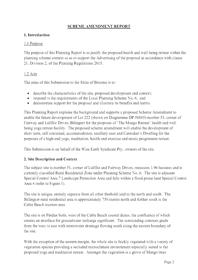
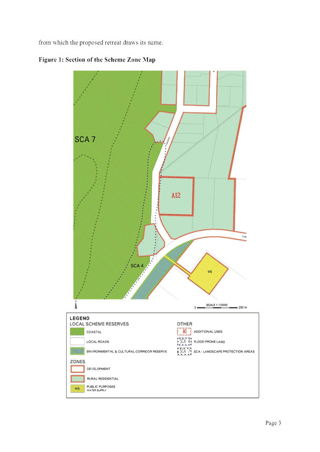
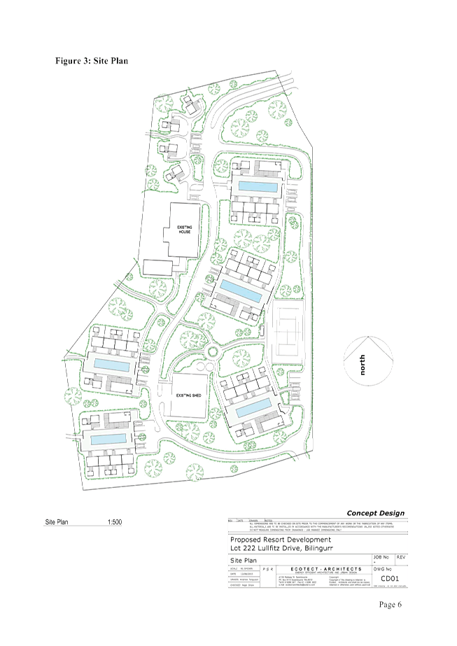
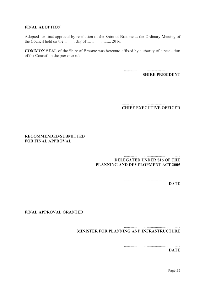
|
Item 9.1.3 - FINAL ADOPTION - AMENDMENT NO. 3 TO LOCAL
PLANNING SCHEME NO. 6 - INCLUSION OF AN ADDITIONAL USE ON LOT 222 (NO. 51)
LULLFITZ DRIVE, BILLINGURR
|
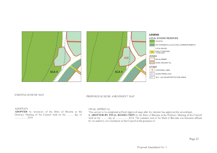
|
Item 9.1.3 - FINAL ADOPTION - AMENDMENT NO. 3 TO LOCAL
PLANNING SCHEME NO. 6 - INCLUSION OF AN ADDITIONAL USE ON LOT 222 (NO. 51)
LULLFITZ DRIVE, BILLINGURR
|
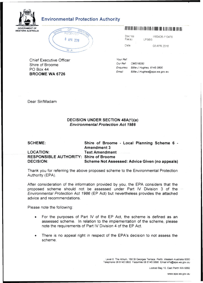
|
Item 9.1.3 - FINAL ADOPTION - AMENDMENT NO. 3 TO LOCAL PLANNING SCHEME NO. 6 -
INCLUSION OF AN ADDITIONAL USE ON LOT 222 (NO. 51) LULLFITZ DRIVE, BILLINGURR
|
|
NO.
|
NAME & ADDRESS
|
AFFECTED PROPERTY
|
SUBMISSION
|
OFFICER COMMENT
|
OFFICER RECOMMENDATION
|
|
1
|
Jim Dodds
Department of Health
PO Box 8172
Perth Business Centre WA 6849
|
Lot 222 (51) Lullfitz Drive,
Bilingurr
|
The
proposed development is required to comply with the draft Country Sewerage
Policy. The subject lot measures around 18,815 m2 in area, based on this
lot size, the density development provisions of the draft Country Sewerage
Policy limits total unsewered development on the lot to the
development’s daily production of wastewater not exceeding 5,350 lt.
The
proponent will need to demonstrate that the total use (including any
additional proposed uses) would generate wastewater to an amount that is less
than 5,350lt/day, and that an appropriate wastewater system for the
development can be accommodated on the lot before the Shire of Broome can
support for the proposal.
A
separate DOH approval for the installation of the wastewater system is
required when the daily wastewater volume exceeds 540 liters.
|
Noted. The Department of
Health’s advice will be included in the Council Agenda Report and the
proponent will need to demonstrate through a future Development Application
that development on the site will not exceed the maximum daily production of
wastewater. The proponent will also need to obtain approval from the
Department of Health for the proposed treatment system.
|
Support. No modifications required.
|
|
2
|
Alan Byrne
Department of Parks & Wildlife
PO Box 65
Broome WA 6725
|
Lot 222 (51) Lullfitz Drive,
Bilingurr
|
The
proposed additional use outlined in your correspondence of 19/04/2016
includes a health and well-being retreat facility comprising short term,
self-contained, single story accommodation and low impact with ancillary uses
and caretaker’s dwelling.
Given
the low impact nature of the above activities and the minimal impact
represented to the threatened ecological community (Monsoon vine thickets
on the coastal sand dunes of Dampier Peninsula, listed as a vulnerable in
Western Australia) located 280m from the lot boundary, Parks and Wildlife has
no objection to the proposed amendment.
|
Noted. The Council Agenda Report
will reflect that the nearest occurrence of vine thickets is 280m from the
subject site and therefore there are unlikely to be any impacts from the
proposed development on this Threatened Ecological Community.
|
Support. No modifications required.
|
|
3
|
Charles Sabato
Water Corporation
Locked
bag 2
Osborne Park Delivery Centre
WA 6916
|
Lot 222 (51) Lullfitz Drive,
Bilingurr
|
The
Water Corporation advises that Shire that it has no concerns with the above
proposed Amendment proceeding.
|
Noted.
|
Support. No modifications required.
|
|
4
|
Duncan Palmer
Department of Water
PO Box 625
Kununurra WA 6743
|
Lot 222 (51) Lullfitz Drive,
Bilingurr
|
The
Department has reviewed the proposed amendment and has no objection for the
Shire of Broome (SoB) to allow for the additional land use on Lot 222
Lullfitz Dr, Bilingurr to proceed.
The
Department would like to SoB to note that the subject land is identified as
being prone to flooding so any additional infrastructure should be
constructed to allow for adequate protection from any floodwaters. Connection
to the sewerage service provider pipelines are available in the area is also
recommended to ensure protection of the local groundwater resources.
|
Noted. Officers have previously
noted that the subject site lies within the ‘Flood Prone Land’
Special Control Area (SCA) under Local Planning Scheme No. 6 (LPS6). Any
future Development Application for the site will need to address the criteria
for this SCA.
The appropriate method of effluent
disposal for the site will be considered at the Development Application
stage. However, it is noted that the subject site is approximately 1
kilometre away from the nearest sewer pipeline and given this it is
considered onerous to require connection to sewer. The Department of Health
has provided advice regarding the site’s capacity for on-site effluent
disposal and this will be communicated to the proponent, with any proposed
system requiring approval from the Department of Health. In this way it is
considered that any impacts on groundwater resources can be minimised.
|
Support in part. No modification required.
|
|
5(a)
|
Gary & Elizabeth Waldron
PO Box 16
Broome WA 6725
|
Lot 222 (51) Lullfitz Drive,
Bilingurr
|
Change
of land use and title holding in a Rural Residential Area
7.1
Merits of Proposal as a specialized tourism facility, the ‘Mango
Retreat’ health and well being facility is a unique high-end yoga,
mediation, health and exercise and music programmes retreat with the
following merits:
· An unobtrusive and secluded space
set against and respectful of the Yawuru Conservation Area and Coastal
Reserve and SCA.
· A unique site separate from all
freehold land and other residential pursuits in the vicinity.
· An alternative from of accommodation
with the focus on the thematic use of yoga, mediation and exercise
programmes.
· A high quality, low key, niche market
tourism facility suitable to satisfy the forecast tourism market that
supplements the other accommodation form provided in Broome.
· Built form responsive to the
environmental setting of SCA 4 proposing elevated single story, separate pod
construction.
· Low impact building footprints that
occupy approximately 14 percent of the site.
The
proposal to repurpose what was built, as a family home on an island block at
the beginning of Lullfitz Drive is not an acceptable amendment to
Broome’s town planning scheme. Lot 222 is in a well established rural
living area north of Broome. Most properties in the area are long held. The
merits of this proposal really only lead to questions.
The site
plan is much bigger that anyone in Lullfitz Drive would be aware. Most blocks
out here are around the 1-hectare mark with the blocks larger on the western
side of Lullfitz, no others are 1.96hec. We, and others we know out this way
were totally unaware that lot 222 now extends over what we thought was a
retention basin. This was built by Council to slow water flow down Lullfitz
Drive in big rain events as part of the realignment of Lullfitz Drive some
years ago. It has been regularly cleared by Council since that time. Any
approved development over this retention area will affect all houses lower in
the area in a flood event. We understand that under the WA and indeed
National Planning regulations all property run-off must be held and retained
on site. This proposal does not meet these conditions. Just putting a
building on stumps and letting the water flow underneath is hardly planning
and should not be approved. The development plan made no mention of any
maintenance process of the retention basin, it does mention the increase of
had stand areas and by implication a reduction of local rainfall retention.
The concrete block retained soil bank to the north of the lot driveway is
designed to maintain a depth of water in the basin allowing for the water to
evaporate and seep in to sub soil rather than rush down the roadway.
|
Attachment 1 to the Agenda Report is
a location plan showing the extents of the subject site. It is noted that the
subject site does not extend to the intersection of Lullfitz Drive and
Fairway Drive. There is a triangular shaped parcel of Unallocated Crown Land
(UCL) situated between the subject site and these roads. The parcel of UCL is
approximately 4,500m2 in size and does not form part of the
proposal.
The subject site attained its
present size as a result of an amalgamation which was completed in 2008 and
resulted in a closed portion of Lullfitz Drive being incorporated into the
subject site. This was supported by Council on 31 August 2006. As part
of this amalgamation the two retention basins and culvert which assist with
dealing with the flow of stormwater were protected through drainage easements
in favour of the Shire of Broome. As part of this arrangement the Shire is
required to maintain this infrastructure, which it does and will continue to
do. An easement for Telstra was also created through this process.
Whilst the design of the development
will be considered through a future Development Application, construction
over the easements will not be supported. The Scheme Amendment report
notes the existence of the easements and states, ‘the detention basins
and stormwater flow path are to remain unobstructed.’
With respect to discharge of
stormwater from the subject site, this will be considered as part of a future
development application. However the submitters are correct in stating that
the Shire’s standard conditions of approval require all stormwater to
be retained on site. The proponent will need to demonstrate this.
|
Support in part. No modifications
required.
|
|
(b)
|
|
|
The site
plans clearly show 36 car parking bays on site but talks about limited
visitor movement and the provision of a bus for patrons is in the document.
We doubt few tourists would stay in such a place without the use of a hire
car. Will they hold yoga/mediation/wedding experiences for others in town,
where will they park??
|
The Scheme Amendment solely concerns
the use of the land, with the configuration of the development to be
considered during a future development application. Parking requirements for
all components of the proposed development will be assessed at this time in
accordance with LPS6.
It is noted that in considering the
Amendment for advertising purposes in February 2016, Council resolved that:
Support for the Scheme Amendment
does not constitute support for the Concept Plan, and that the design of development
on site will be considered on its merits when a formal Development
Application is lodged.
|
Note submission.
|
|
(c)
|
|
|
The
business plan proposals don’t suggest but imply that the options to
“get out” if the venture is not a success will be provided by
this scheme modification. The development of the block would allow it to be
just another block of units should the ‘Mango Retreat’ health and
well being facility not be what is described in the application. The units
would have been sold (or would sell) and are then managed by a strata
company. It will not revert to Rural Living but will continue to be used for
what we see as around town in the tourist precincts; a block with holiday
units, maybe with a managers quarters. Lot 222 should remain as one lot.
|
The Scheme Amendment solely concerns
the use of the land, with the configuration of the development to be
considered during a future development application. However, with respect to
the future management of the development, it is noted that Clause 4.31.2 of
Local Planning Scheme No. 6 states, with respect to subdivision in the
‘Rural Residential’ zone:
4.31.2
Subdivision Requirements
(a)
The subdivision of land which proposes additional lots or reduces the
size of existing lots, will not be supported by Council unless-
i. a structure plan has been approved for the land proposed to be subdivided;
or
ii. the subdivision is in conformity with clauses 4.31.2(c) (d) and €
when the land is within the precincts referred to in those clauses.
(e)
Bilingurr and Wattle Drive –
Lot sizes in the Bilingurr Precinct and Wattle Drive Precinct should not be
less that 1 hectare with the exception of Lots 404 and 407 Lullfitz Drive
(Bilingurr Precinct) which are subject to flooding and have no further
subdivision potential below the existing 2 hectare lot size.
Strata subdivision is considered
subdivision and hence the above requirements will apply. As LPS6
requires a lots to be a minimum of 1 hectare in the ‘Rural
Residential’ zone, it is unlikely that strata titling of the subject
site will be supported by officers.
|
Support in part. No modification
required.
|
|
(d)
|
|
|
The high
voltage power supply to the residents to the north runs over the proposed
development site. Should it go ahead; who pays for the re-routing of the line
and in line with all new sites; gets it underground for Cyclonic reliability
and to meet current standards.
|
Upgrades to the power supply are not
required to facilitate an additional land use on the subject site, and
generally are not required as part of a Development Application. Typically
‘undergrounding’ of power would occur as part of a new
subdivision. No subdivision is currently proposed and as discussed in the
point above the Shire is unlikely to support future strata subdivision as it
would result in the creation of lots less than 1 hectare in size, which is
contrary to the provisions of Local Planning Scheme No. 6.
It is noted that the Shire referred
the proposed Scheme Amendment to Horizon Power and no comment was received.
|
Not support.
|
|
(e)
|
|
|
The
history of this block goes back a while and we think it was developed by a
local
Vet as a
Mango Farm. We understand that this is the second house to be built on the
block, the first house being relocated to another site. The reason this block
is free standing is that the blocks to the north and west along Lullfitz
Drive were never taken up when offered by the Lands Department many years
ago, they were probably too much hill for most people to develop at the time.
|
This is not relevant to consideration
of the proposed Scheme Amendment.
|
Not support.
|
|
(f)
|
|
|
As a more
general comment the advertising of this amendment by Council and the local
sign on site gives no indication of what is really proposed. It uses only
general terms and describes numbers and regulations. It is very poor
information. A person reading the sign or advertisement from Council really
needs to seek further advice for better understandings. If Council wants
items like to this be supported and understood then they and the proponents
need to do a much better job in the dissemination of the proposal’s
detail not just advertise notices alone.
We
don’t recall if we got a letter about the proposal but the standard
letters are also not information but rather a notice only about processes.
|
In advertising Scheme Amendments the
Shire is required to adhere to the process set out in the Planning and
Development (Local Planning Schemes) Regulations 2015 (the Regulations).
This includes using the forms prescribed by the Department of Planning.
The text on the sign is consistent with Form 2B – Advertisement for
a standard or complex Local Planning Scheme amendment and therefore is
considered to be appropriate. Furthermore, the sign indicates that plans and
documents explaining the amendment are on display at the Shire Administration
Office and on the Shire website.
In addition to the process in the
Regulations, the Shire also has a Local Planning Policy 8.23: Public
Consultation – Planning Matters. In this policy a Scheme Amendment
is shown as ‘Level C’ consultation. This level requires written
notice to all landowners within a radius of at least 100 metres of the
application site for land within the townsite boundaries or at least 500 metre
radius for land outside of a townsite. Whilst the subject site is located
within the Broome townsite, given the larger lot size in the locality
officers elected to notify all landowners within a 500m radius. The
submitters did not receive a letter as their property is outside this radius.
|
Not support.
|
|
9.1.4 DRAFT JOINT MANAGEMENT PLAN
FOR THE YAWURU MINYIRR BURU CONSERVATION PARK
LOCATION/ADDRESS: Nil
APPLICANT: Nil
FILE: NAT
55
AUTHOR: Director
Development Services
CONTRIBUTOR/S: Nil
RESPONSIBLE
OFFICER: Director
Development Services
DISCLOSURE
OF INTEREST: Nil
DATE OF REPORT: 20
June 2016
|
|
SUMMARY: The
Shire of Broome is a signatory to two Indigenous Land Use Agreements (ILUAs)
with the Yawuru Native Title Holders Aboriginal Corporation Registered Native
Title Body Corporate, Nyamba Buru Yawuru Ltd and other State government and
associated bodies. Both ILUAs are dated 25 February 2010. In
accordance with the ILUAs a number of reserves were created for the purposes
of conservation, recreation and traditional and customary Aboriginal use and
enjoyment, and jointly vested with the Shire and Yawuru (in-town reserves).
The ILUAs require the in-town reserves to be managed in
accordance with a management plan and the Joint Management Agreement included
in the ILUAs. Officers from the Shire, the Department of Parks and
Wildlife and Nyamba Buru Yawuru Ltd have been working together to prepare the
management plan for the in-town reserves.
The purpose of this report is to seek Council’s
endorsement of the draft management plan that has been prepared, so it can be
released for public comment.
|
BACKGROUND
Previous
Considerations
OMC 19 April 2012 Item
9.2.4
OMC 21 February 2013 Item
9.2.13
OMC 24 November 2014 Item
10.2
The Shire of Broome is a signatory to
two Indigenous Land Use Agreements (ILUAs) with the Yawuru Native Title Holders
Aboriginal Corporation Registered Native Title Body Corporate (Yawuru RNTBC),
Nyamba Buru Yawuru Ltd (NBY Ltd), the State of Western Australia and
other State government and associated bodies.
The ILUAs are dated 25 February 2010,
and provide for the creation of a number of reserves under the Land
Administration Act 1997 (LA Act) for the purposes of conservation,
recreation and traditional and customary Aboriginal use and enjoyment.
This land is all within the Broome townsite, and is referred to as the
“in-town reserves” (see map in Attachment 1 of this
report).
In accordance with the ILUAs,
management responsibility for the in-town reserves is jointly vested with the
Shire and Yawuru RNTBC, with assistance to be provided by the Conservation and
Land Management Executive Body (through the Department of Parks and
Wildlife). Joint management of the in-town reserves must be pursuant to a
cultural management plan (CMP) and a management plan prepared in
accordance with s49 of the LA Act and the Joint Management Agreement in the
ILUAs.
The ILUAs provide for the creation of
other land jointly managed by the Shire, Yawuru RNTBC and the Department of
Parks and Wildlife (DPaW), and also by the Yawuru RNTBC and DPaW.
This land, including the in-town reserves, is know collectively as the
“Conservation Estate”. The Joint Management Agreement in the
ILUAs provides for the creation of the Yawuru Park Council (YPC) to
provide for the administration of the Conservation Estate and the development
of management plans for the Conservation Estate.
Two management plans have been
developed for land jointly managed by the Yawuru RNTBC and DPaW for what is
known as the out-of-town reserves and the Roebuck Bay Marine Park. These
plans are in final draft form and are being finalised prior to being submitted
for approval by the Minister responsible for the Conservation and Land
Management Act 1984 (CALM Act). A further management plan will be
required for what is known as the inter-tidal zone, which is located approximately
600 metres north of the rocks on Cable Beach and is jointly managed by the
Shire, Yawuru RNTBC and DPaW.
At the Ordinary Meeting of Council (OMC)
on 19 April 2012, Council considered the draft Yawuru CMP, and resolved to
receive an extract from the draft CMP and provide comments on this
extract. Council also resolved to:
· endorse
staff comments provided for the preparation of the in-town reserves management
plan;
· request the
Chief Executive Officer to ensure the draft in-town reserves management plan
contains adequate financial and resource requirement details for its
implementation; and
· requests the
Chief Executive Officer to advise the YPC that the draft management plan should
be made available for public comment for a period of 42 days prior to
consideration by Council and that Council will consider the draft management
plan together with any public comments received.
The Shire subsequently engaged
consultants CCS Strategic to prepare a baseline document to inform the draft
management plan. This document, titled the “Broome Coastal Reserves
Master Plan” was finalised in February 2013. Using feedback
obtained from the Council and the Shire’s Executive Management Group, the
document established Council’s position regarding the in-town reserves.
At the OMC on 21 February 2013,
Council resolved to note the Broome Coastal Reserves Master Plan and require
the Chief Executive Officer to have the report incorporated into a detailed
Shire submission on the draft in-town reserves management plan.
The CMP was finalised by the Yawuru
RNTBC in March 2013.
A special meeting of the YPC was held
on 7 April 2014 to allow for discussion and agreement on further actions
required to progress the draft in-town reserves management plan. A
resolution was made that discussed the formatting and way forward in relation
to the development of the management plan, and included a resolution that DPaW
engage a consultant to review the content and layout of the plan, and to
prepare a draft management plan. The resolution also set out a process
for the completion of the management plan, which involves endorsement by both
the Shire and Yawuru prior to the management plan being released for public
consultation and final endorsement by YPC after public consultation.
A consultant was subsequently engaged
to progress the development of the management plan and a revised draft was
provided in August 2014. However, due to unforeseen circumstances the
consultants were unable to continue with the management plan project.
At the OMC on 27 November 2014,
Council received minutes from the Special Meeting of YPC held on 7 April 2014
and resolved to note resolutions made by the YPC in relation to the progress of
the in-town reserves masterplan. The resolution sought a progress and
status report from DPaW to ensure the consultants engaged for the preparation
of the management plan were able to complete the project.
A new consultant, Natural Area
Consulting Management Services, was subsequently engaged to complete the draft
management plan in July 2015. This consultant is still working on the
project and has prepared the current draft management plan.
COMMENT
Officers from the Shire, DPaW and NBY
Ltd have been working together on finalising a management plan for the in-town
reserves in accordance with the ILUAs. As a starting point, this
management plan has to be consistent with the CMP and the management principles
in the Joint Management Agreement, which states that the Conservation Estate
will be jointly managed for the following objectives:
· the
preservation and promotion of the Aboriginal cultural and heritage values of
the Conservation Estate;
· the
preservation and promotion of the natural environmental values of the
Conservation Estate, including indigenous flora and fauna;
· the
preservation and promotion of archaeological values of the land;
· the
provision of recreational facilities and facilitation of recreational
activities in the Conservation Estate, particularly in the in-town reserves;
· the
regulation of public access to the out-of-town reserves, inter-tidal zone and
Roebuck Bay Marine Park areas of the Conservation Estate to fulfil so much of
the demand for recreation by members of the public as is fitting having regard
to the matters set out in the first three dot points above;
· access to
and occupation and use of the Conservation Estate by Yawuru People for purposes
consistent with Yawuru Culture and tradition and to preserve and sustain the
native title rights and interests recognised in the Native Title Determination;
· employment,
service provision and training opportunities for the Yawuru People in the
administration, management and control of the Conservation Estate;
· commercial
and economic opportunities being made available to the Yawuru Community and the
Yawuru RNTBC in preference to any other applicants, subject to such activities
being consistent with the management of the Conservation Estate;
· the
implementation, monitoring, assessment and audit of the effectiveness of the
management plan; and
· the
provision, construction, repair, maintenance and replacement of buildings and
infrastructure in the coastal areas of the joint managed land.
The in-town reserves are jointly
vested in the Shire and Yawuru. However, in accordance with the
assistance agreement forming part of the ILUAs, DPaW are responsible for
providing the following assistance in relation to the management of the in-town
reserves:
· advice as to
the scope and content of the management plan for the in-town reserves;
· day to day
management of the in-town reserves in accordance with the management plan;
· provision of
qualified rangers to undertaken day to day management of the in-town reserves
in accordance with the management plan; and
· administrative
support for the day to day management of the in-town reserves.
Therefore, DPaW have been heavily
involved in the preparation of the management plan.
As a result of the work undertaken by
Officers from the three organisations, the draft Joint Management Plan for the
Yawuru Minyirr Buru Conservation Park (JMP) has been prepared (see Attachment
2 to this report). An overview of each of the sections of the JMP is
provided below.
Summary
This section provides background to
the in-town reserves and the Broome townsite. It clarifies that while the
in-town reserves are called the “Yawuru Minyirr Buru Conservation
Park” for the purposes of the JMP, the in-town reserves are not
Conservation Park as defined in, or for the purposes of, the CALM Act.
Information on the ability for the public to make comment on the plan are
provided.
Yawuru Minyirr Buru Conservation
Park Management Context
This section sets out some background
to the need for the JMP and the connection to the joint management principles
in the Joint Management Agreement. Information is also provided on:
· Yawuru
Country and the Yawuru People;
· the Broome
community generally;
· the Native
Title Determination and the ILUAs;
· the
management arrangements for the entire Conservation Estate;
· the CMP;
· the tenure
arrangements, vesting and joint management arrangements for the in-town
reserves;
· a diagram
setting out the governance arrangements for the joint management of the
Conservation Estate;
· the location
and tenure of the in-town reserves; and
· roles and
responsibilities of the YPC, Yawuru RNTBC, Shire and DPaW.
Note that this section clarifies that
each party to the Joint Management Agreement is liable for its actions only and
not the actions of other parties in relation to the management of the in-town
reserves. It also acknowledges that the Shire may be required to enter
parts of the in-town reserves with cultural values or culturally significant
sites to undertake urgent works for public safety.
Performance assessment
This section talks about key
performance indicators (KPIs) that have been developed for management
outputs included in the JMP. It also provides for annual reviews to be
undertaken to ensure the effectiveness of the JMP.
Vision and goals
The stated vision for the in-town
reserves in the JMP is:
Yawuru people and their partners
working together to restore, protect and maintain the cultural, natural and
recreational values of the conservation estate for the enjoyment and benefit of
present and future generations.
Management of Yawuru Minyirr Buru
Conservation Park
This section contains a series of
tables outlining management arrangements for values of the in-town reserves and
specific issues associated with the management of the in-town reserves. Each
table contains management objectives, management strategies, performance
measures, targets and reporting requirements. Each management strategy is
linked to the CMP, is prioritised as either High, Medium or Low and has a lead
agency assigned.
A description and background is
provided for each value or management issue.
An overview of each value and
management issue and associated management arrangements is provided below.
Yawuru cultural values –
Living Cultural Landscape
This relates to Yawuru Country and
the associated narratives and rituals that link Yawuru people to particular
areas of country for all time. These narratives along with events,
cultural heritage areas and cultural heritage sites which shaped the lives of
Yawuru people make up the living cultural landscape.
The management objectives for living
cultural landscape are:
1. to
ensure that activities within the Yawuru Minyirr Buru Conservation Park do not
adversely affect sites and opportunities for Yawuru people to have ongoing
cultural connection and expression; and
2. to
promote increased understanding of Yawuru values and concepts of living
cultural landscape.
To ensure these objectives are met, a
number of management strategies are specified as follows:
1. Prepare
a colour-coded ‘Living Cultural Landscape’ spatial map that
indicates the significance and general location of culturally significant
areas.
2. Develop
operational protocols and similar to enable the appropriate management of
activities.
3. Ensure
cultural heritage sites are protected, in particular highly significant and
sensitive sites at immediate risk.
4. Assess
human activities that may inhibit the protection of the living cultural
landscape in accordance with the operational protocols.
5. Develop
and implement a cultural education and interpretation programme that considers
appropriate communication actions including signage.
Performance measures and targets are
specified, including a target that there be no deterioration of important sites
as a result of human activity.
Yawuru cultural values –
Traditional Ecological Knowledge
This relates to the need to ensure
Yawuru’s knowledge and understanding of the flora, fauna, landscape
features, seasons and cycles that make up their country are captured in the
management of the in-town reserves.
The management objective for traditional
ecological knowledge is to apply Yawuru traditional ecological knowledge and
integrate it with modern conservation science and land management.
To ensure this objective is met, two
management strategies are specified as follows:
1. Develop processes and protocols for consulting and
integrating Yawuru traditional ecological knowledge in the management of the Yawuru Minyirr Buru Conservation Park.
2. Develop a database of the most important elements of
Yawuru traditional ecological knowledge and investigate opportunities for
integrating this with conservation science and land management.
Performance measures and a target is
specified. The target is that traditional ecological knowledge is
incorporated into ongoing management activities.
Yawuru cultural values –
Enjoyment of Country and Customary Practices
This relates to the need to ensure
Yawuru people retain the ability to access the in-town reserves for customary
practices.
The management objective for
enjoyment of country and customary practices is to recognise and support the
right of Yawuru people to continue customary practices and to benefit from
their country consistent with the Yawuru Minyirr Buru Conservation Park.
To ensure this objective is met, two
management strategies are specified as follows:
1. Identify
factors that may inhibit the Yawuru people to enjoy country or maintain
customary practices.
2. If
required, develop special access arrangements needed for continuance of
customary practices.
Performance measures and a target is
specified. The target is that factors that may inhibit the Yawuru people
enjoying country or maintaining customary practices are identified.
Yawuru cultural values –
Responsibility for Country
This relates to the need to ensure
Yawuru people are able to exercise their responsibility ensure the sustainable
use of resources and protect the in-town reserves.
The management objective for
responsibility for country is to facilitate and maintain the opportunity for
Yawuru to carry out their roles and responsibilities as protectors and managers
of their country and culture.
To ensure this objective is met, a
number of management strategies are specified as follows:
1. Ensure
Yawuru has access to country for management purposes.
2. Continue
to develop the Yawuru Ranger Program and investigate the authorisation of
officers for enforcement activities such as vehicle usage in prohibited areas
and camping.
3. Develop
operational protocols and similar to enable the appropriate management of
activities
4. Investigate
opportunities to increase the number of Yawuru RNTBC members involved in
management of the Yawuru Minyirr Buru Conservation Park (including, for
example, exploring opportunities for traditional owners as cultural rangers).
Performance measures and a target is
specified. The target is that Yawuru continues to have access to country
for management purposes.
Physical values –
Geomorphology
This relates to the striking and
richly diverse coastal and geomorphological features of the in-town reserves, including
the beaches and dunes, sandstone cliffs, semi-hardened red sand and fossils.
The management objective for
geomorphology is for the geomorphology and geomorphic processes that maintain
the cultural and ecological values of the Yawuru Minyirr Buru Conservation Park
are not adversely altered by human activity.
To ensure this objective is met, a
number of management strategies are specified as follows:
1. Ensure that potential
adverse effects on geomorphic features and processes from development and management
activities are taken into account and mitigated.
2. Implement strategies to
address adverse or potential effects on geomorphology from inappropriate
vehicle and pedestrian access as required.
3. Undertake research
activities to characterise the geomorphic features and processes and their
associated ecological function.
4. Ensure appropriate coastal
setback distances are used when developing recreation and other infrastructure
within the Yawuru Minyirr Buru Conservation Park.
Performance measures and targets are
specified, including a target that consideration of geomorphic features and
processes occurs early in the planning phase of management activities.
Physical values – Hydrology
and Drainage
This relates to ensuring high water
quality while supporting the natural fluxes in water quantity and flow in order
to protect the key values of the in-town reserves. It also relates to
managing stormwater impacts and drainage in the reserves.
The management objectives for
hydrology and drainage are as follows:
1. Increase knowledge of the ecological water
requirements of groundwater dependent species and ecosystems within the Yawuru
Minyirr Buru Conservation Park.
2. Work with agencies that have water resource protection
and management roles and responsibilities to maintain the water regimes that
sustain key cultural and ecological values of the
Yawuru Minyirr Buru Conservation Park.
3. Ensure that stormwater runoff from urban
development does not significantly impact the Yawuru Minyirr Buru Conservation
Park.
To ensure these objectives are met, a
number of management strategies are specified as follows:
1. Implement or support a water monitoring program in
conjunction with the relevant water resource management agencies that improves
understanding of baseline water regime conditions (i.e. quality, quantity and
flow patterns) and helps to identify limits of acceptable change and ecological
water requirements for groundwater dependent ecosystems/species, including
further research into hydrogeology of specific areas.
2. Identify, implement or assist management interventions
as needed in response to matters of concern identified through the water
monitoring program.
3. Groundwater abstraction from the Yawuru Minyirr Buru Conservation Park requires consent of the YPC.
4. Ensure that management operations within the Yawuru
Minyirr Buru Conservation Park do not negatively affect natural water regimes.
5. Identify drainage needs and assess potential impacts
within the Yawuru Minyirr Buru
Conservation Park.
6. If required, develop and implement strategies to
address drainage needs and impacts within the Yawuru Minyirr Buru Conservation Park.
7. Implement a
monitoring program (e.g. of vegetation, erosion, rubbish, sediment deposits
etc.) which improves understanding of the impacts associated with changes to
drainage practices and infrastructure on important ecological and cultural
values of the Yawuru Minyirr Buru Conservation Park.
Performance measures and targets are
specified, including a target that impacts within the Yawuru Minyirr Buru
Conservation Park due to inappropriate drainage are avoided.
Ecological values – Flora,
Fauna and Ecological Communities
This relates to the native threatened
and priority/significant flora and fauna species found in the in-town
reserves. It also relates to the following six ecological
communities:
· Beaches and
sand dunes;
· Pindan;
· Vine
thickets;
· Mangroves;
· Saltmarsh
and saline grassland; and
· Melaleuca
thickets.
The management objectives for flora,
fauna and ecological communities are as follows:
1. To conserve the flora, fauna and
ecological communities of the Yawuru Minyirr Buru Conservation Park.
2. To increase understanding of the flora,
fauna, and ecological community values of the Yawuru Minyirr Buru Conservation
Park and of the factors presenting a threat to those values.
To ensure these objectives are met, a
number of management strategies are specified as follows:
1. Carry out
research and monitoring to establish the baseline condition of the ecological
communities within the Yawuru Minyirr Buru Conservation Park and assist with
identifying and managing significant threats.
2. If
required, implement strategies to minimise the effects of threatening processes
on native flora, fauna and ecological communities.
3. Determine
the need for access restrictions as necessary to protect flora, fauna and
ecological communities, and implement as required.
4. Implement
research, monitoring and recovery actions for threatened and priority species
and communities.
Performance measures and targets are
specified, including a target that key protection strategies are implemented.
Ecological values –
Introduced Flora Management
This relates to the need to manage
weeds and prevent introduced plant species from impacting on the ecological
values of the in-town reserves.
The management objective for
introduced flora is to ensure the impact of environmental weeds on the Yawuru
Minyirr Buru Conservation Park is minimised.
To ensure these objectives are met,
two management strategies are specified as follows:
1. Assess current extent and impact of weeds in the
Yawuru Minyirr Buru Conservation Park.
2. Develop a Weed Management Plan to be informed, where
relevant, by the Shire’s Weed Management Strategy.
Performance measures and targets are
specified, including a target that there is no increase in the abundance,
distribution or extent of priority environmental weeds from current levels.
Ecological values –
Introduced Fauna Management
This relates to the need to manage
feral animals and prevent feral animals from impacting on the ecological values
of the in-town reserves.
The management objective for
introduced fauna is to minimise the impact of feral animals on the cultural,
ecological and social values of the Yawuru Minyirr Buru Conservation Park.
To ensure these objectives are met,
two management strategies are specified as follows:
1. Assess current extent and impact of feral and pest
animals in the Yawuru Minyirr Buru Conservation Park.
2. Consider options for feral and pest animal control in
the Yawuru Minyirr Buru Conservation Park that are appropriate and supported by the local
community.
Performance measures and targets are
specified, including that a target that there is minimal impact from feral animals
to native fauna and flora within the Yawuru Minyirr Buru Conservation Park.
Ecological values – Fire
Management
This relates to the need to ensure
that appropriate bushfire mitigation strategies are implemented that avoid
impacts on the ecological values of the in-town reserves.
The management objectives for fire
management are as follows:
1. To mitigate the risk of adverse impacts of bushfire on
human life, property and community assets.
2. To promote the maintenance of habitat biodiversity and
the persistence of ‘fire regime specific’ biota and habitats.
To ensure these objectives are met, a
number of management strategies are specified as follows:
1. Carry
out fire risk assessments in accordance with State Planning Policy 3.7, the
State Bushfire Prone Areas Map and the Bush Fires Act 1954 (WA).
2. Develop
and implement a Bushfire Mitigation Strategy identifying strategies relating to
fuel reduction burning, provision of access, establishment of strategic fire
breaks and other relevant strategies in liaison with key stakeholders.
3. Maintain
best available and up to date knowledge of fire management in accordance with
the Bush Fires Act 1954 (WA), Yawuru traditional knowledge and Shire
policies and ensure the ecological and social values of the Yawuru Minyirr Buru
Conservation Park are included in response plans for fire management to assist
in addressing any significant fire events.
4. Monitor
and record the effects of fire on the most important and vulnerable values and
assets, and on habitats or species which may require specific fire regimes (for
example Monsoonal Vine Thickets, Keraudrenia species, etc).
5. Ensure
that Yawuru Rangers are trained in fire management principles and practices.
Performance measures and a target is
specified. The target is that the impacts associated with fire in the Yawuru
Minyirr Buru Conservation Park are minimised.
Social and economic values –
History and Heritage
This relates to the need to protect
non-indigenous heritage sites and Aboriginal heritage sites (both registered
and unregistered) within the in-town reserves.
The management objective for history
and heritage is to ensure consideration and the protection of cultural heritage
sites and values within the Yawuru Minyirr Buru Conservation Park.
To ensure this objective is met, the
following management strategies have been identified:
1. Identify
important non-indigenous heritage sites.
2. Identify
key coastal Aboriginal heritage sites.
Performance measures and targets are
specified, including a target that impacts on heritage sites is avoided.
Social and economic values –
Recreation
This relates to the need to ensure
that recreational use of the reserves is maintained, while minimising impacts
on the ecological and cultural values of the in-town reserves. It also
recognises the importance of the reserves for activities such as wildlife
viewing, walking, picnicking and recreational fishing.
The management objective for
recreation is to ensure that recreational activities are supported and managed
in a manner that is consistent with maintaining the ecological and
socio-economic values of the Yawuru Minyirr Buru Conservation Park.
To ensure this objective is met, a
number of management strategies are specified as follows:
1. Maintain the Recreation Master Plan (RMP).
2. Develop and implement an interpretation plan.
3. Monitor environmental impacts associated with recreation by
developing a database to record this information on an ongoing basis.
4. Prioritise and cost infrastructure
identified within the RMP.
5. Seek external funding opportunities for
capital works for recreation sites.
6. Conduct a visitor survey programme to
better understand visitor use, numbers and satisfaction of visitor experience.
Performance measures and a target is
specified. The target is that a high quality recreation experience is provided.
Social and economic values –
Dogs
This relates to the continuation of
the use of the in-town reserves by dog owners.
The management objective for dogs is
to provide equitable access within the Yawuru Minyirr Buru Conservation Park
for dog owners.
To ensure this objective is met, the
need to use appropriate signage to advise the community where dogs are allowed
and where they are not permitted as been specified as a management objective.
A performance measure and a target is
specified. The target is that signage is installed in appropriate
locations if not already present.
Social and economic values –
Horses
This section outlines the use of the
in-town reserves by persons riding horses, however no management arrangements
are specified as the activity is not considered to pose a threat to the values
of the Yawuru Minyirr Buru Conservation Park.
Social and economic values –
Access
This relates to the need to ensure
public access to the in-town reserves is maintained, while minimising impacts
on the ecological and cultural values of the reserves.
The management objectives for access
management are as follows:
1. To maintain public access to the Yawuru
Minyirr Buru Conservation Park in a way that does not compromise the cultural,
ecological or socio-economic values of the Yawuru Minyirr Buru Conservation
Park.
2. To maximise public compliance with
regulations related to the ongoing management of the Yawuru Minyirr Buru
Conservation Park.
To ensure these objectives are met, a
number of management strategies are specified as follows:
1. Map the locations of all formal and
informal access locations and infrastructure within the Yawuru Minyirr Buru
Conservation Park.
2. Consolidate and
formalise access locations, closing surplus access ways with agreement from
YPC.
3. If required,
implement access management arrangements to ensure access to culturally
sensitive areas is managed appropriately, with all access restrictions to be
agreed by YPC.
4. Implement access
restrictions as necessary to protect flora, fauna and ecological communities,
with all restrictions to be agreed by YPC.
5. Implement strategies
as necessary to prevent adverse impacts on the values of Reserves from
inappropriate vehicle or pedestrian access.
6. Educate, mentor and
support trainee rangers through working with Shire Rangers, Parks and Wildlife
authorised officers and other agencies to gain experience in patrol and
enforcement activities, to the extent possible within the existing resources of
the Shire and Parks and Wildlife.
7. Develop and implement
a collaborative patrol and enforcement program to:
- ensure
compliance with relevant regulations; and
- maximise
efficiency and effectiveness of patrol and enforcement activities.
8. Apply culturally
appropriate and sensitive management to illegal camping issues within the
Yawuru Minyirr Buru Conservation Park.
9. Facilitate
cross-authorisation of government enforcement officers as appropriate
10. Maintain a database of
compliance statistics and issues.
Performance measures and targets are
specified, including a target that there is a decreasing trend of
non-compliance within the Yawuru Minyirr Buru Conservation Park.
Social and economic values –
Visual Amenity
This relates to the need to maintain
the very high visual amenity values and landscape quality of the in-town
reserves.
The management objective for visual
amenity is to ensure consideration and the protection of the visual amenity
values within the Yawuru Minyirr Buru Conservation Park.
To ensure this objective is met, a
number of management strategies are specified as follows:
1. Identify the key characteristics and map the spatial extent
of important landscapes.
2. Ensure recreation and commercial activities are consistent
with maintaining the landscape.
3. Minimise visual impacts of structures through appropriate
placement, design and colour of materials used.
Performance measures and a target is
specified. The target is that visual amenity is considered on an ongoing basis.
Social and economic values –
Commercial activities
This relates to providing for the use
of the in-town reserves for commercial and tourism activities, while ensuring
these activities occur in a way that minimises impacts on the ecological and
cultural values of the reserves.
The management objectives for commercial
activities are as follows:
1. To ensure that commercial tourism activities are encouraged and managed
in a manner that is consistent with maintaining the cultural, ecological and
social-economic values of the Yawuru Minyirr Buru Conservation Park.
2. To maintain the ecological and socio-economic values of the Yawuru
Minyirr Buru Conservation Park that are important to commercial operators,
through the appropriate management of human based activities that adversely
impact upon these values.
3. To provide opportunities for Yawuru community and Yawuru RNTBC to develop
and operate commercial businesses consistent with maintaining the values of the
Yawuru Minyirr Buru Conservation Park.
To ensure these objectives are met, a
number of management strategies are specified as follows:
1. Assist Yawuru people and others to identify areas of commercial
opportunity within the Yawuru Minyirr Buru Conservation Park.
2. Determine and develop appropriate management protocols for assessment,
licencing and management of commercial activities and events.
3. Approvals issued for commercial activities and events with appropriate
conditions.
4. Provide Yawuru people with new commercial opportunities in the Yawuru
Minyirr Buru Conservation Park.
Performance measures and a target is
specified. The target is that all commercial operators have the required
approvals and abide by the relevant conditions.
Social and economic values –
Resource values
This relates to the use of the
in-town reserves for mineral, oil and gas extraction as well as the extraction
of raw materials.
The management objective for resource
use is to protect the values of the Yawuru Minyirr Buru Conservation Park from
any adverse effects associated with resource use activities in or near to the
Park.
To ensure this objective is met, two
management strategies are specified as follows:
1. Obtain raw materials for
use within the Yawuru Minyirr Buru Conservation Park from outside the Park,
unless any adverse effects on the natural and cultural values are demonstrated
to be very low and there are no other practical, environmentally or culturally
acceptable alternatives.
2. Ensure that rehabilitation
has been effective by post-rehabilitation monitoring and evaluation, and
implementation of any additional or alternative restorative works if required.
Performance measures and targets are
specified, including a target that land is restored to equivalent or better
condition at the conclusion of raw material extraction activities.
General management measures
– Asset management
This section sets out that DPaW is
owner of all assets located within the in-town reserves and is responsible for
the ongoing maintenance of these assets. It requires DPaW to prepare an
Asset Management Plan for the in-town reserves.
The management objective for asset
management is to ensure assets within the Yawuru Minyirr Buru Conservation Park
are managed appropriately.
To ensure this objective is met, a
number of management strategies are specified as follows:
1. Develop an Asset Management
Plan.
2. Undertake annual
inspections of infrastructure within the Yawuru Minyirr Buru Conservation Park.
3. Prepare an annual Capital
Works Program based on the Asset Management Plan, to be approved by the YPC.
Performance measures and targets are
specified, including a target that an Asset Management Plan is endorsed by the
YPC.
General management measures
– Waste management
This section sets out the need for a
waste management plan for the in-town reserves.
The management objective for waste
management is to ensure waste is appropriately managed within the Yawuru
Minyirr Buru Conservation Park.
To ensure this objective is met, the
development and implementation of a Waste Management Plan is specified as a
management strategy.
Performance measures and targets are
specified, including a target that waste is managed appropriately.
General management measures
– Information, Education and Interpretation
This relates to the need to develop
an education and interpretation program to increase public awareness and
understanding of conservation, Yawuru culture and management issues in the
in-town reserves.
The management objective for
information, education and interpretation is to enhance community understanding
of, and support for, the values of the Yawuru Minyirr Buru Conservation Park
through education and interpretation programs.
To ensure this objective is met, a
number of management strategies are specified as follows:
1. Develop and implement an integrated education and
interpretation plan to ensure users of the Yawuru Minyirr Buru Conservation
Park understand:
· the
importance of the key cultural, ecological and socio-economic values of the
Yawuru Minyirr Buru Conservation Park as set out in the JMP;
· the
integration of traditional ecological knowledge into the management of the
Yawuru Minyirr Buru Conservation Park;
· the
rights of Yawuru people, as the recognised traditional owners in and around
Broome to enjoy Yawuru country and maintain their cultural practices;
· areas
of cultural and historical significance and culturally appropriate behaviour in
these areas;
· the
flora and fauna that are sensitive to disturbance (e.g. roosting shorebirds)
and appropriate behaviour to minimise impacts;
· the
effects of dumping rubbish and garden refuse and the threat invasive plants
pose to the values of the Yawuru Minyirr Buru Conservation Park;
· appropriate
behaviours to reduce illegal vehicle access and camping; and
· appropriate
behaviours to reduce the risk of injury and ensure public safety.
2. Ensure the education and interpretation program for
the Yawuru Minyirr Buru Conservation Park is appropriately integrated with
relevant outcomes and messages from the CMP and other management plans for the
Conservation Estate.
3. Ensure that Yawuru people have an active role in the
education and interpretation programs.
4. Install culturally appropriate signage for the Yawuru
Minyirr Buru Conservation Park for educational purposes where appropriate and
with approval from the YPC and consistent with the interpretive plan
5. Encourage and assist the tourism industry to provide
educational courses/materials to their staff and customers to foster community
stewardship of the Yawuru Minyirr Buru Conservation Park.
6. Develop promotional and educational material.
Performance measures and a target is
specified. The target is that 50% of visitors to the Yawuru Minyirr Buru
Conservation Park are aware of the existence of the Yawuru Minyirr Buru
Conservation Park, their values and the management requirements that apply
within five years of the release of the JMP.
General Management Measures
– Public Participation
This relates to allowing for third
parties to undertake community based and conservation programs in the in-town
reserves and participate in management activities within the reserves.
The management objective for public
participation is to encourage and facilitate ongoing public participation in
the management of the Yawuru Minyirr Buru Conservation Park.
To ensure this objective is met, a number
of management strategies are specified as follows:
1. Consider
and establish appropriate structures and mechanisms to provide for community
input and involvement in ongoing management of the Yawuru Minyirr Buru
Conservation Park.
2. Develop
and implement a public participation program for the Yawuru Minyirr Buru
Conservation Park which encourages community involvement through a range of
opportunities including education and monitoring programs.
3. Maintain
records of public participation.
Performance measures and a target is
specified. The target is that ongoing public participation in the
management of the Yawuru Minyirr Buru Conseration Park is facilitated.
General Management Measures
– Research and Monitoring
This relates to allowing for third
parties to undertake research projects within the in-town reserves.
The management objective for research
and monitoring is to provide access and opportunities for scientific research
in the Yawuru Minyirr Buru Conservation Park.
To ensure this objective is met, a
management strategy is specified that is to encourage and facilitate as far as
practicable community and other involvement in research and monitoring
programs, providing assistance where possible.
A performance measure and a target is
specified. The target is that there is increased knowledge of the various
values within the Yawuru Minyirr Buru Conservation Park.
General Management Measures
– Risk Management and Safety
This relates to ensuring risks to
public safety within the in-town reserves is mitigated through the development
and implementation of a risk management plan by DPaW.
The management objective for risk
management and safety is to minimise risks to visitors within the Yawuru
Minyirr Buru Conservation Park from natural and other hazards.
To ensure this objective is met, a
number of management strategies are specified as follows:
1. Undertake
a biannual risk assessment and develop a risk management plan to identify
hazards/risks and proposed corrective/mitigation actions.
2. Identify
the estimated costs associated with each proposed corrective action.
3. Consider
the recommendations of the Broome Townsite Coastal Hazard Risk Management and
Adaptation Plan in undertaking the risk assessment and implementing the risk
management plan.
Performance
measures and a target is specified. The target is that there are no
serious injuries reported in the Yawuru Minyirr Buru Conservation Park.
Conclusion
Officers consider the JMP to be a
sound basis upon which to continue the joint management of the in-town
reserves. The JMP clarifies both Yawuru’s and the Shire’s
interests and responsibilities in relation to the ongoing management of
reserves, and delineates responsibility between Yawuru, the Shire and
DPaW.
The management framework established
by the JMP will provide ongoing guidance and support for management activities
and priorities into the future.
Therefore, it is recommended that
Council endorse the JMP for public consultation.
CONSULTATION
Officers from the Shire have worked
closely with representatives from Yawuru and officers from DPaW in relation to
the JMP. In addition, YPC has made resolutions influencing the content of
the JMP and a consultant, Natural Area Consulting Management Services, provided
advice and assistance in the development of the JMP.
Yawuru will be formally considering
the JMP and it will be submitted to the Yawuru RNTBC for approval to undertake
public consultation. Following approval/endorsement of the JMP by Yawuru
and Council, YPC endorsement of the JMP will be sought before public
consultation commences.
The JMP will need to be released for
42 days public consultation. The organisation that will be responsible
for managing this public consultation process has not yet been determined at
this stage, but it is likely to be DPaW.
To ensure all necessary steps are
taken so that the JMP can obtain endorsement by YPC and also undergo public
consultation, it is recommended that Council authorise the Chief Executive Officer
to take any necessary action to obtain YPC endorsement and ensure public
consultation occurs. It is also recommended that the Shire’s YPC
Representative Members be authorised to make or support any relevant motions at
a YPC meeting so that the JMP can be endorsed/approved by the YPC and undergo
public consultation.
STATUTORY ENVIRONMENT
Land
Administration Act 1997
Section 46. Care, control and management of reserves
(1) The
Minister may by order place with any one person or jointly with any 2 or more
persons the care, control and management of a reserve for the same purpose as
that for which the relevant Crown land is reserved under section 41 and
for purposes ancillary or beneficial to that purpose and may in that order
subject that care, control and management to such conditions as the Minister
specifies.
(2) The
Minister may, with the consent of the management body of a reserve and of the
holders of any interests within the reserve, by order vary any condition to
which the care, control and management of the reserve is subject.
(3) The
Minister may —
(a) by
order confer on a management body power, subject to section 18, to grant a
lease or sublease or licence over the whole or any part of the Crown land
within the reserve in question for the purposes referred to in
subsection (1); and
(b) approve
a mortgage of any such lease.
(3a) The Minister may by order —
(a) without the consent of the management body of a reserve,
vary —
(i) an order made
under subsection (3)(a); or
(ii) an
order made under section 33 of the repealed Act or section 42 or 43
of the Land Act 1898 7 that subsists as an order made under
subsection (3)(a),
in relation to whether or not prior approval
in writing of the Minister is required to a grant of a lease, sublease, or
licence; or
(b) with the consent of the management body of a reserve, vary any other
condition to which —
(i) an order made
under subsection (3)(a); or
(ii) an order made
under section 33 of the repealed Act or section 42 or 43 of the Land
Act 1898 7 that subsists as an order made under
subsection (3)(a),
is
subject.
(3b) The Minister’s approval
under section 18 is not required for the exercise of a power conferred under subsection (3)(a)
unless —
(a) the person on whom the
power is conferred is —
(i) a body corporate that is constituted for a public
purpose under an enactment and is an agency of the Crown in right of the State;
or
(ii) a person referred to in subsection (10)(b),
and
the order provides that the Minister’s approval under section 18 is
required; or
(b) the person on whom the
power is conferred is a person other than a person referred to in
paragraph (a).
(4) If
an unmanaged reserve is the subject of —
(a) a
lease granted under section 47; or
(b) a
licence, or a lease or profit à prendre, granted under section 48,
or of any other
interest in the unmanaged reserve, the Minister may under subsection (1)
place the care, control and management of that reserve with a management body
subject to that licence, lease or profit à prendre or other interest,
the term of which continues unbroken by that placing.
(5) An
order made under subsection (1), (2), (3) or (3a) does not create any interest in Crown land in
the relevant reserve in favour of the management body of that reserve.
(6) If
Crown land reserved under section 41 for the purpose of recreation is
leased or subleased under a power conferred under subsection (3), the
lessee or sublessee may, unless the terms of the management order or the lease
or sublease otherwise provide, restrict public access to the area leased.
(7) A person with whom
the care, control and management of a
reserve is placed by order under subsection (1) has, by virtue of
this subsection, the capacity, functions and powers to hold and deal with the
reserve in a manner consistent with the order, any order conferring power on
that person under subsection (3)(a) and this Act to the extent that the
person does not already have that capacity or those functions and powers.
(8) Subsection (7)
does not authorise a management body to perform a function or exercise a power
if another enactment expressly prevents the person from performing that
function or exercising that power, or expressly authorises another person to
perform that function or exercise that power.
(9) Any
instrument in relation to the care, control and management of a reserve entered
into or given by a person holding an office referred to in
subsection (10)(b)(i) or (iii) is taken to have been entered into or given
by the person for the time being holding that office.
(10) In subsection (1), a reference to a person is a reference
to —
(a) a person having perpetual succession;
(b) a person not having perpetual
succession who is —
(i) a Minister to whom the Act specified in the
relevant order is for the time being committed by the Governor; or
[(ii) deleted]
(iii) a person holding a prescribed office.
(11) If an order made under section 33 of the repealed Act subsists under
clause 16(1) of Schedule 2 as if it were a management order under
section 46(1), the Minister may by order vary that order to place the
care, control and management of the reserve the subject of the order with a
person referred to in subsection (10).
(12) An order made under section 46(1) before the coming into operation
of section 12 of the Land Administration Amendment Act 2000 1 may be varied by the Minister by order to place
the care, control and management of the reserve the subject of the order with a
person referred to in subsection (10).
Conservation and Land
Management Act 1984
Section 33. CEO, functions of
(1) The
functions of the CEO are,
subject to the direction and control of the Minister —
(f) to
provide advice to, or undertake work for or jointly with, and to supply
services or facilities to, any department, public or private body or other
person, whether in the State or elsewhere if the Minister is of the opinion
that the provision of that advice or the undertaking of that work is in the
public interest;
POLICY IMPLICATIONS
Nil.
FINANCIAL IMPLICATIONS
The development
of management strategies, assigning of priorities and identification of lead
agencies has been done taking into account limitations in the Shire’s
resources. The Joint Management Agreement states that the Shire will be
responsible for costs it incurs in relation to the joint management and
maintenance of the in-town reserves, including its participation in the YPC and
the costs of public and other insurances relevant to the in-town reserves.
The Joint
Management Agreement outlines funding that will be provided by the State for
the management of the Conservation Estate. The Agreement states that when this
funding has ended, Yawuru, DPaW and the Shire will work cooperative to ensure a
sufficient level of funding is obtained from the State Government, Federal
Government or any other relevant third parties, for the purposes of continuing
the joint management arrangements.
RISK
Should Council not proceed with the
JMP, it would be in breach of the Joint Management Agreement and there is a
risk that Yawuru or the State could commence legal action to compel the Shire
to act in accordance with the Agreement.
More likely however, is that the
failure of Council to endorse or proceed with the JMP would have a significant
detrimental impact on the relationship between the Shire, Yawuru and the State
government. The risk should Council proceed in this way is considered
Extreme. To mitigate this risk, Council should continue to work with
Yawuru and DPaW to ensure the JMP is finalised in the near future.
The risk to Council if endorsing the
JMP is that resourcing implications may arise from the management strategies in
the JMP that place an unreasonable burden on the Shire. However this risk
is considered Low, given the careful development of the management strategies,
the inclusion of priorities for each management strategy and the identification
of an appropriate lead agency for each strategy.
STRATEGIC
IMPLICATIONS
Our People
Goal – Foster a community environment that is accessible, affordable,
inclusive, healthy and safe:
Effective communication
Accessible and safe community spaces
Participation in recreational and
leisure activity
A healthy and safe environment
Our Place
Goal – Help to protect the nature and built environment and cultural
heritage of Broome whilst recognising the unique sense of the place:
A unique natural environment for the
benefit and enjoyment of current and future generations
A preserved, unique and significant
historical and cultural heritage of Broome
Retention and expansion of
Broome’s iconic tourism assets and reputation
VOTING REQUIREMENTS
Simple Majority
|
REPORT
RECOMMENDATION:
That Council:
1. Endorses
the draft Joint Management Plan for the Yawuru Minyirr Buru Conservation Park
for public consultation as shown in Attachment 2 to this report;
2. Authorises
the Chief Executive Officer to take any action necessary to obtain Yawuru
Park Council endorsement/approval of the draft Joint Management Plan and
ensure public consultation of the draft Joint Management Plan occurs; and
3. Authorises
the Shire’s Yawuru Park Council Representative Members to make or
support any motions relating to the draft Joint Management Plan at a Yawuru
Park Council meeting so that the Joint Management Plan can be
endorsed/approved by the Yawuru Park Council and undergo public consultation.
|
Attachments
|
1.
|
Map of in-town reserves
|
|
2.
|
Draft Joint Management
Plan for the Yawuru Minyirr Buru Conservation Park
|
|
Item 9.1.4 - DRAFT JOINT MANAGEMENT PLAN FOR THE YAWURU
MINYIRR BURU CONSERVATION PARK
|
|
Item 9.1.4 - DRAFT JOINT MANAGEMENT PLAN FOR THE YAWURU MINYIRR BURU
CONSERVATION PARK
|


A Management Partnership
between the
YAWURU REGISTERED NATIVE TITLE BODY CORPORATE
and the
SHIRE of BROOME
|
|
Joint Management Plan for the Yawuru Minyirr Buru
Conservation Park
Draft: V8.1 – July 2016
|
|
NOTE: This document is in DRAFT form.
Further consultation with Yawuru RNTBC, the Shire of
Broome and PaW is required.
This draft currently has no formal status or
approval.
Draft Joint Management Plan for the Yawuru Minyirr
Buru Conservation Park.
Version 8.1
IN CONFIDENCE
Not for Distribution
|
|
S
This page left
blank intentionally
|
|
Date
|
Year
|
Version
|
Comments
|
|
6-10 February
|
2012
|
Development
|
First Broome visit- workshops, field trip and meetings
with Yawuru/ Shire/ PaW.
|
|
26-30 March
|
2012
|
Development
|
Second Broome visit- workshops, field trips and meetings
with Yawuru/ Shire/ PaW.
|
|
10 April
|
2012
|
Development
|
First draft of: a) enjoyment of country and customary
practice; b) commercial tourism; c) fire; and d) drainage circulated to
Yawuru/ Shire/ PaW through Yawuru Park Council working group.
|
|
16-20 April
|
2012
|
Development
|
Third Broome visit. Workshops, field trips and meetings
with Yawuru/ Shire/ PaW.
|
|
26 April
|
2012
|
1
|
First draft circulated to Yawuru, Shire and PaW through
Yawuru Park Council Working Group
|
|
10 May
|
2012
|
1 A
|
Amendments from discussions with Yawuru and Sarah Yu.
|
|
24 May
|
2012
|
1 B
|
Amendments following PaW review.
|
|
8 June
|
2012
|
2
|
Second draft circulated to Yawuru, Shire and PaW through
Yawuru Park Council Working Group.
|
|
12 June
|
2012
|
|
Workshop/ handover of draft scheduled for Yawuru/ Shire
cancelled (to be rescheduled for August TBC).
|
|
19 July
|
2012
|
2 a
|
Update to document control section and removal of some
incorrect referencing. Circulated to Yawuru/ Shire/ PaW through Yawuru Park
Council working group.
|
|
9 October
|
2012
|
|
Workshop/ presentation to Yawuru Board, Shire of Broome
Councillors and staff.
|
|
13 March
|
2013
|
|
Received CCS strategic report from Shire of Broome for
tabling at next YPC meeting.
|
|
15 May 2013
|
2013
|
|
Shire of Broome confirmed that the CCS strategic document
is the position of the Shire (excluding the recommended next stages).
|
|
July
|
2013
|
3
|
Updated to align with CCS Strategic information and
updated Out of Town / Marine and Intertidal plans.
|
|
20 March
|
2014
|
4
|
Update of V3 framework as developed by YPCWG (19 March
2014).
|
|
April
|
2014
|
5
|
Update as requested by YPC meeting (7 April 2014).
|
|
11 December
|
2014
|
6
|
Senior Officer Group (SoG) to confirm Version Control to
progress plan from 12 December 2014.
|
|
October
|
2015
|
7
|
Updated draft for stakeholder group comment and review.
|
|
July
|
2016
|
7.1
|
Incorporation of comments from stakeholder group ahead of
endorsement.
|
|
July
|
2016
|
8
|
Updated draft based
on ongoing discussions with stakeholder group.
|
|
19 July
|
2016
|
8.1
|
Minor edits ahead of
Yawuru Board and Shire of Broome Council meetings
|
|
Please note all Versions were progressed via the Yawuru
Park Council Working Group (YPCWG). Representatives include Yawuru RNTBC,
Shire of Broome and Parks and Wildlife.
|
|
The Yawuru
Minyirr Buru Conservation Park Joint Managers Senior Officer Group (SOG)
comprising the Yawuru NBY General Manager, the SoB CEO and the West Kimberley
Manager of Parks and Wildlife declare that this is the correct version for
the Joint Management Partners to progress and finalise.
|
|
|
Peter
Yu
|
|
Kenn
Donohoe
|
|
Alan
Byrne
|
|
|
Chief
Executive Officer
|
|
Chief
Executive Officer
|
|
West
Kimberley Manager
|
|
|
Yawuru
Nyamba Yawuru Pty Ltd
|
|
Shire
of Broome
|
|
Parks
and Wildlife
|
|
Signature of
General Manager
|
|
Signature of
Chief Executive
Officer
|
|
Signature of
West Kimberley Manager
|
|
|
►Date
|
|
|
|
|
|
.
|
Item 9.1.4 - DRAFT JOINT MANAGEMENT PLAN FOR THE YAWURU
MINYIRR BURU CONSERVATION PARK
|
Summary
The Yawuru
Minyirr Buru Conservation Park incorporates a number of small coastal and
inland reserves within the Broome Town site. These reserves are one important
component of the Yawuru Conservation Estate which comprises intertidal,
sub-tidal and adjacent terrestrial reserves in and around Broome and Roebuck
Bay. While the land subject to this management plan is referred to as the
Yawuru Minyirr Buru Conservation Park, the land is not a Conservation Park as
defined in, or for the purposes of, the Conservation and Land Management Act
1984 (WA).
The Minyirr
Buru Conservation Park (Park) incorporates areas which are a living cultural
landscape the Yawuru people value, use for customary practice and have a
responsibility to manage. The responsibility for management of Country is of
fundamental importance for the Yawuru people. The location of the reserves
comprising the Park makes them of great significance for the local Broome
community and visitors to Broome. In recognition of the importance to Yawuru
and the Broome community, these reserves will be jointly ‘owned’
and managed by the Yawuru and the Shire of Broome.
With a
population of approximately 15,000, and which rises to 35,000 – 40,000 or
more in the high season (July – September), the coastal sites are heavily
used for boat launching, swimming, fishing, sporting, sightseeing and other
visitor and recreational activities. These areas are valued by the local
community and contribute to the Broome lifestyle. The Park encompasses sites
that are major attractions for visitors to Broome such as Cable Beach,
Gantheaume Point and Minyirr Park which must be maintained to support the local
tourism industry.
The close
proximity of the reserves to an increasing resident population and a strong
tourism industry will place increasing pressure on these sites from local
people and visitors. Past use had an impact on these sites and careful and
increased management is required to ensure the cultural, environmental,
recreational and aesthetic values are maintained and managed for the future.
This draft
Management Plan has been prepared by Yawuru, the Shire of Broome and Parks and
Wildlife and outlines a range of proposed management actions for the next ten
years to ensure these important areas are managed sustainably and for the use
and benefit of Yawuru people, the broader Broome community and visitors to
Broome.
This Plan
is now released for consideration by the community and your comments on the
management actions proposed for these important areas are sought. The Plan will
be available for public comment for a period of three months. Following the
close of the public consultation period, the Yawuru and Shire of Broome will
consider issues raised in any submissions that are received and develop a final
management plan.
Contents
Summary. 6
1.0 Yawuru Minyirr Buru Conservation Park
Management Context 9
1.1 Yawuru buru, Yawuru ngarrungunil –
Yawuru Country, Yawuru People. 10
1.2 The Broome Community. 11
1.3 Native Title Determination and
Indigenous Land Use Agreements. 13
1.4 Holistic Management Across Yawuru
Conservation Estate. 14
1.5 Walyjala-jala buru jayida jarringgun
buru nyamba Yawuru ngan-ga mirli mirli (Planning for the Future: Yawuru
Cultural Management Plan) 15
1.6 Joint Management of Yawuru Minyirr Buru
Conservation Park. 15
1.7 Location and Tenure. 17
2.0 Performance Assessment 19
3.0 Vision and Goals. 20
4.0 Management of Yawuru Minyirr Buru
Conservation Park. 21
4.1 Yawuru Cultural Values. 21
4.1.1 Living Cultural Landscape (KPI) 22
4.1.2 Traditional Ecological Knowledge (KPI) 24
4.1.3 Enjoyment of Country and Customary
Practices (KPI) 26
4.1.4 Responsibility for Country (KPI) 27
4.2 Physical values. 29
4.2.1 Geomorphology. 29
4.2.2 Hydrology and Drainage. 32
4.3 Ecological Values. 37
4.3.1 Flora, Fauna and Ecological Communities
(KPI) 38
4.3.2 Fire Management 50
4.4 Social and Economic Values. 53
4.4.1 History and Heritage. 53
4.4.2 Recreation. 54
4.4.3 Access. 60
4.4.4 Visual Amenity. 63
4.4.5 Commercial Activities. 64
4.5 General Management Measures. 68
4.5.1 Asset Management 68
4.5.2 Waste Management 70
4.5.3 Information, Education and
Interpretation. 71
4.5.4 Public Participation. 73
4.5.5 Research and Monitoring. 74
4.5.6 Risk Management and Safety. 75
5.0 Yawuru Language Glossary. 77
6.0 References. 79
7.0 Acronyms. 87
Appendix 1 – Tenure of Reserves
within Yawuru Minyirr Buru Conservation Park. 89
1.0 Yawuru Minyirr Buru
Conservation Park Management Context
This draft
Management Plan (Plan) describes the proposed management arrangements for the
Yawuru Minyirr Buru Conservation Park (Park), one part of the Yawuru
Conservation Estate recently established in and around Broome, Western
Australia (Map 1). This plan is proposed as one of a suite of management plans
that will apply to the Yawuru Conservation Estate (Map 2). The Yawuru Conservation Estate will be
managed by the Yawuru Registered Native Title Body Corporate (YRNTBC) in
partnership with a number of joint management partners. The entire Yawuru Buru
Conservation Estate will be jointly managed, although the management parties
and arrangements vary across the conservation estate.
This draft plan
has been prepared in accordance with the Indigenous Land Use Agreements (ILUA)
(2010). The Park includes a number of A-class reserves that will be jointly
managed by the Yawuru RNTBC and the Shire of Broome (Shire).
The joint
management principles for the Yawuru Minyirr Buru Conservation Park as
documented in the ILUA are:
i. preservation and promotion
of Aboriginal cultural and heritage values of the Conservation Estate
ii. preservation and promotion
of the natural and environmental values
iii. preservation and promotion
of archaeological values
iv. provision of recreational
facilities and facilitation of recreational activities, particularly in the
Townsite area
v. regulation of public access
to the freehold areas, Intertidal Reserves and Marine Park areas of the
Conservation Estate
vi. access to and use of the land
by Yawuru people in accordance with their cultural and other objectives
vii. access to, and occupation
and use of, the Conservation Estate by the Yawuru people for purposes
consistent with Yawuru culture and tradition, and to preserve and sustain native
title rights and interests recognised in the Determination
viii. employment, service
provision and training opportunities for the Yawuru people in the
administration, management and control of the Conservation Estate
ix. commercial and economic opportunities
are made available to the Yawuru community and the Yawuru RNTBC in preference
to any other applicant, subject to activities being consistent with the
management of the Conservation Estate
x. implementation, monitoring,
assessment and audit of the effectiveness of the Management Plan
xi. provision, construction,
repair, maintenance and replacement of buildings and infrastructure in the
Coastal Park for any of the foregoing purposes, Yawuru people and the Yawuru
corporations.
The Plan sets
out the values within the Park, the threats, pressures and the associated
management strategies. Different parts of the Yawuru Conservation Estate are
subject to differing tenure and management arrangements, but the values of the
terrestrial and marine areas are intrinsically linked to the values in this
Plan. Planning and management will be integrated, complementary and as seamless
as possible across the various components of the Conservation Estate.
Some Yawuru
names (e.g. for places, plants and animals) are used throughout this Plan in
italicised text. Map 3 shows some place names referred to in this Plan, and
Yawuru names for places have been included as well as official names. The
Yawuru place names are, however, not official or formally recognised. Note that
Yawuru language can be spelt in alternative ways. A glossary of Yawuru language
names used in this plan is provided in Section 5.0.
1.1 Yawuru buru, Yawuru ngarrungunil – Yawuru Country, Yawuru
People
For
thousands of years Yawuru people have lived along
the foreshores of Roebuck Bay, across the pindan plains, as far inland as the Walan-garr (Edgar Ranges) and along the fringes of the Great
Sandy Desert. Yawuru country is land and sea moulded by the cycle of seasonal
change. It is a living cultural landscape with which Yawuru people have a
dynamic and enduring relationship. In Yawuru law, everything comes from Bugarrigarra, the time when creative beings
traversed the country, naming the landscape, defining the languages and setting
down rules and customs. Created and given
form by Bugarrigarra, country
is the source of spirit, culture, language,
and is where spirits return on death.
From Bugarrigarra Yawuru people have responsibility to look after the country and to ensure that their traditions are passed on to
future generations. Every time
Yawuru people go out on country, hunting and fishing, they live culture –
these activities are an expression of culture and enable Yawuru people to
reconnect with country, spirit places, ancestors and Bugarrigarra (Yawuru Registered Native Title Body Corporate
(RNTBC), 2011).
The
relationship of Yawuru people to country is at the heart of their cultural
responsibilities. This is expressed through liyan
(well-being), which comes from Yawuru people’s
connection to country, ancestors and Yawuru way of life. It reflects a sense of
belonging to Yawuru society, and represents the feeling people hold,
individually and collectively, particularly when Yawuru people are on country.
Liyan is about
relationships—with country, family, community. It is what gives meaning
to people’s lives. Yawuru people’s connection to country and joy of
celebrating our culture and society is fundamental to having good liyan.
Patrick Dodson
Mabu (good)
liyan expresses Yawuru people’s
emotional strength, dignity and pride. The guiding principle for good
management of Yawuru country is that Yawuru people have to maintain good, clear
liyan with the country within the
modern, ever-changing world. To ensure Yawuru people can keep mabu liyan they have to:
· visit country
· respect ancestors
· continue cultural traditions
· respect Bugarrigarra
· look after all the plants, animals and
other resources that are part of country
· maintain and protect sacred places
· foster a relationship with country
· assume cultural responsibility as
individuals and collectively for the future use and development of Yawuru
country, and
· achieve balance between keeping things
as they are and developing the country.
Yawuru people want to generate an understanding in the wider community of how
Yawuru people feel about and relate to country, with respect for Bugarrigarra and cultural traditions and
practices (Yawuru RNTBC, 2011).
For
countless generations Yawuru people managed country in a sustainable way,
relying on their intimate knowledge of the natural environment, and applying
customary law and practices passed down from ancestors. As Yawuru people have
always done, this knowledge is passed onto their children when they go hunting,
fishing, gathering and camping. Understanding the subtle changes in country and
following the seasons is part of Yawuru cultural heritage and provides Yawuru
people with a guide to where and how to harvest and look after the resources of
country. As Yawuru activities change in response to the annual cycle of the
seasons, Yawuru people believe their way of living has minimal impact on the
environment. They want to use this knowledge to guide and inform successful
conservation and management of Yawuru land and sea (Yawuru RNTBC, 2011).
In recent
times, Broome has undergone massive transformation as population,
infrastructure, housing and industry have expanded. Yawuru people, the native
title holders of their country, are well aware of the many challenges and
opportunities such changes present for managing country and, in partnership
with others, are well placed to meet them.
1.2 The Broome Community
Located at
the southern gateway to the Kimberley, Broome has an extraordinary beauty, a
unique cultural and natural history and is a favourite holiday destination for
visitors from Australia and the world. The Shire of Broome has a resident
population of approximately 15,000 and more than 35,000 – 40,000 visitors
annually. Broome’s major industries include cattle, pearling trade,
tourism, fishing, aquaculture, agriculture, horticulture, mining and
exploration, community and cultural arts. The Broome Peninsula provides the
township of Broome with a coastal frontage in almost every direction.
Broome has
a rich multicultural history, including Aboriginal people from across the
Kimberley along with
European explorers, and Malaccan (Malay), Arabian, Chinese and Indonesian
fishermen. Contact with other cultures is believed to date back as far as the 1500s
and Dutchman, Dirk Hartog, is credited with the first known European contact in
1616. Abel Tasman passed by in 1644.
The first Europeans known to
have set foot in this region were from William Dampier's ship Roebuck,
when he came ashore in La Grange Bay in search of water in 1700. Dampier had
visited the coast on an earlier voyage in 1688, when he careened the Cygnet
in King Sound. Other visitors included the French explorer, Nicholas Baudin,
who charted the coast in the Geographe and Naturaliste during his
exploratory journey of 1801-1804, and the sailors from the Beagle, which
lost an anchor while in Roebuck Bay in 1838 and were the first Europeans
recorded as setting foot on the mangrove beaches of the Bay.
On 21 November 1883, when
the town site of Broome was gazetted, the settlement at Roebuck Bay consisted
of a few pearling camps along the foreshore near Dampier Creek. The camps were
occupied by the Malay crews of the pearling luggers and by the European owners of
small pearling boats. The first surveyed town lots formed an inverted L-shape
along the peninsula and along the west-northwest alignment of the inland track,
the latter giving Napier Terrace its characteristic bend. Lots 10, 12 and 13
were adjacent to the landing at the bottom of Napier Terrace and were gazetted
as unnumbered reserves.
With the introduction
of hard-hat diving technology, Chinese, Filipinos, Malays, Koepangers, and
Japanese were recruited as divers and boat crew and Chinatown was originally
known as ‘Japtown’ because of the large number of Japanese divers
resident there, with former becoming more popular after World War 2. Many of
the businesses in the area were run by Chinese, who were also cooks, gardeners
and tailors.
Broome evolved as a
segregated town, with wealthy pearlers and Europeans living at one end in
elegant bungalows surrounded by tropical gardens and tended by mostly
Aboriginal servants. At the other end was Chinatown where the Asian and
‘coloured’ populations lived and played, and where much of the
commercial and business activities took place. The pearling masters were
distinguished by their white suits, an anachronism in a town of red dirt and
bore water. With the proximity of rich pearl shell beds in Roebuck Bay and 80
Mile Beach, Broome soon became known as the pearling capital of the world.
Broome’s
pearling workforce was halved in 1914 with the commencement of World War 1 as
men enlisted and European markets for mother-of-pearl collapsed. War returned
to Broome in 1941 when the Japanese attacked Pearl Harbour and Japanese
residents of Broome were interned in camps. In March 1942, Japanese Zeros
bombed aircraft in Roebuck Bay and at the aerodrome, destroying 16 Flying Boat
planes. Over time, Broome recovered and the pearling industry evolved into a
new market in cultured pearls in the 1950s, changing the way pearl shell was
harvested as smaller live shell were collected for the pearl farms. These
changes remain today.
Broome also developed
as the administrative and service centre for the region. Oil exploration within
the Kimberley region and offshore was headquartered at Broome, and a new deep
water port and jetty were opened at Entrance Point in 1966 to cater to the
growing beef export industry and larger ships. Air services expanded, a new
meatworks was built in the town and Shire offices replaced the old Roads Board
office in 1968. Improved services such as refrigeration and air-conditioning
were available, and a new supply of fresh water, and modern sewerage and electricity
facilities were installed.
Since the 1970s,
tourism has expanded with increased flights to and from the town, along with
improved roads making Broome more accessible. The growth of the tourism and
other industries has brought great changes to the town, extending it westwards
to Cable Beach as the population has expanded. Growth in population and general
wealth have meant the expansion of facilities and services for residents, seen
in the areas of administration, health, education, recreation, capital works,
and specialist services, particularly noticeable in the area of services for
the Aboriginal communities.
1.3 Native Title
Determination and Indigenous Land Use Agreements
With the High Court decision in Mabo and Wik the Commonwealth
Government introduced the Native Title Act 1993 (Cwlth) (Native Title
Act). Subsequently, the Yawuru people began a 12-year journey to seek
recognition of their native title rights through the Federal Court of Australia
and negotiations with the State Government. On 28 April 2006, the Federal Court
determined that the Yawuru people are the recognised native title holders of
the lands and waters in and around Broome.
History hasn’t always been
kind to Yawuru people. We had no say when our land, our home, was taken from us
and we were pushed towards the edges. But we stayed strong and true to our
culture. We can now take our rightful place in the Broome community.
Gajai Frank
Sebastian (Yawuru RNTBC 2011)
In February 2010, the Yawuru RNTBC, the Government of Western
Australia, the Shire and other relevant parties signed two ILUAs – the Yawuru
Prescribed Body Corporate Indigenous Land Use Agreement and the Yawuru
Area Agreement Indigenous Land Use Agreement (National Native Title
Tribunal 2010a, 2010b). An ILUA is an agreement under the Native Title Act
between a native title group and others about the use and management of land
and waters. These ILUAs resolved compensation issues and clarified that native
title continued to exist for the Yawuru people. The ILUAs provide for the establishment
and joint management of the Yawuru Conservation Estate.
More
information on native title, the Yawuru people’s journey for native title
determination and the ILUAs can be found on the website for the National Native
Title Tribunal (National Native Title Tribunal 2010c), on the Yawuru website (www.yawuru.com) and in
the Yawuru Cultural Management Plan.
1.4 Holistic Management
Across Yawuru Conservation Estate
While this Plan is proposed
as one of a suite of joint management plans that will apply to the Yawuru
Conservation Estate, the cultural, ecological, social and economic values of
the Yawuru terrestrial and marine conservation reserves are implicitly linked.
As such, a well-integrated management approach capable of protecting and
managing the values in a culturally appropriate manner across the Yawuru
Conservation Estate is required. Management objectives, strategies, performance
measures and targets identified in this Plan will complement those for the
other Yawuru Conservation Estate management plans.
The various components of
the Yawuru Conservation Estate are subject to varying tenure arrangements and
therefore a suite of management plans (shown on Map 2) will apply to Yawuru
Conservation Estate:
· Yawuru Minyirr Buru Conservation Park
Management Plan (this Plan)
· Yawuru Birragun Conservation Park
Management Plan
· Northern Intertidal Area Management Plan
· Yawuru Nagulagun/Roebuck Bay Marine Park
Management Plan.
These plans are all informed
by the Yawuru Cultural Management Plan.
1.5 Walyjala-jala buru jayida jarringgun buru
nyamba Yawuru ngan-ga mirli mirli (Planning for the Future: Yawuru Cultural
Management Plan)
 The Yawuru Cultural Management Plan was developed by
the Yawuru RNTBC, as agreed in the ILUAs, to provide a foundation document to
guide planning and management of the Yawuru Conservation Estate. The plan
addresses Yawuru customs, practices and customary law, and provides detail on
Yawuru policies, visions and requirements to be taken into account during the
development of management plans for the Yawuru Conservation Estate.
The Yawuru Cultural Management Plan was developed by
the Yawuru RNTBC, as agreed in the ILUAs, to provide a foundation document to
guide planning and management of the Yawuru Conservation Estate. The plan
addresses Yawuru customs, practices and customary law, and provides detail on
Yawuru policies, visions and requirements to be taken into account during the
development of management plans for the Yawuru Conservation Estate.
As a
comprehensive articulation of the aspirations and responsibilities of the
Yawuru native title holders, the Yawuru Cultural Management Plan is an
authoritative information source for the various joint management partners and
the wider community. The development of the Yawuru Cultural Management Plan
involved all facets of the Yawuru organisational system and it will remain a
key document for the joint management of the Yawuru Conservation Estate.
The Yawuru
Cultural Management Plan was a primary information source for many of the
culturally based concepts and values outlined in the Plan. Copies of the Yawuru
Cultural Management Plan may be obtained through Nyamba Buru Yawuru Ltd
(contact details available at the end of this document).
1.6 Joint Management of
Yawuru Minyirr Buru Conservation Park
In accordance with the
ILUAs, the Park, comprises a number of reserves (Appendix 1), created in
accordance with Section 42 of the Land Administration Act 1997 (WA) (LA
Act) to be managed for the purpose of ‘conservation, recreation and
traditional and customary Aboriginal use and enjoyment’. The Minister for
Lands shall place the Townsite areas for care, control and management jointly
with Yawuru RNTBC and the Shire of Broome under Section 46 of the Land
Administration Act 1997 (WA), with assistance to be provided by the
Executive Body as per the Assistance Agreement under Section 33 (I)(f) of the Conservation
and Land Management Act 1984 (WA) (CALM Act).
In placing the care, control
and management of the Park with Yawuru and the Shire through the LA Act, the
local government may, as stipulated by Section 3.54 of the Act, do anything for
the purposes of controlling and managing the land that it could do under
Section 5 of the Parks and Reserves Act 1895 (WA). The management of the
Park will be pursuant to the Yawuru Cultural Management Plan and this
Plan, which has been prepared in accordance with Section 49 of the LA Act and
the Joint Management Agreement (JMA).
The JMA, a
sub-agreement of the ILUAs, describes various management arrangements for the
Yawuru Conservation Estate including management principles, roles and
responsibilities for each party, decision-making processes and administrative
functions. In accordance with the JMA, the Yawuru Park Council (YPC) has been
established to jointly administer the management of the conservation estate.
The YPC comprises representative members from the Yawuru RNTBC, Parks and
Wildlife and the Shire, with administration of the Conservation Estate having
regard to the differing joint management arrangements and associated
responsibilities. The YPC’s role includes:
· preparation
of management plans for the jointly managed conservation estate, ensuring these
are consistent with the vision and policies set out in the Yawuru Cultural
Management Plan
· strategic
monitoring of implementation of the joint management plans
· assessment
of the effectiveness of joint management of the Yawuru Conservation Estate.
This Plan has been developed
through the collaboration of the Yawuru RNTBC and the Shire with the assistance
of Parks and Wildlife, as per the Assistance Agreement in the ILUA under
Section 33 (1)(f) of the CALM Act. It will guide management of the Park for 10
years from the date of approval by Minister of Lands, until it is either
replaced by a new plan, or as a result of a review initiated by either party.
Public Liability
Yawuru, the Shire and Parks
and Wildlife acknowledge the indemnity provisions in Section 11.7 of the JMA
and agree that each party is liable for its actions only and not the actions of
the other parties in relation to the management of the Park.
Urgent Works
Both Yawuru and the Shire
recognise the importance of protecting the Yawuru people’s cultural
values and culturally significant sites. However, both parties recognise
and acknowledge that Shire employees may be required to undertake work in areas
containing these values and/or sites in certain extenuating
circumstances. Therefore, through this Plan the parties authorise Shire
employees to enter such areas if required to conduct urgent works for public
safety. The Shire undertakes that it will seek to contact Yawuru before
these works have been undertaken to ensure there is understanding between the
parties in relation to the need for and nature of the works undertaken, and to
obtain advice on how the works are carried out.
1.7 Location and Tenure
The Park
comprises twenty land parcels extending  from
the Dampier Creek Intertidal Zone, around the Broome Peninsula and north Bilingurr within the Broome town site
boundary (Figure 1), and covers an area of 1384.6349 ha (Appendix 1).
from
the Dampier Creek Intertidal Zone, around the Broome Peninsula and north Bilingurr within the Broome town site
boundary (Figure 1), and covers an area of 1384.6349 ha (Appendix 1).
The
roles and responsibilities of the joint management partners and the YPC for the
Park are described in Table 1 and Management Orders will necessitate the joint
care, control and management by the Yawuru RNTBC and the Shire. The joint
management parties may (by written agreement) add to, or subtract from the area
of the Yawuru Conservation Estate. Opportunities may arise over the life of
this plan to add areas of cultural or conservation value to the Yawuru
Conservation Estate. These will be considered if, and as they arise.
Should land
be added to the Park over the life of this plan, it will be managed
consistently and in accordance with the Vision, Strategic Goals and Objectives
of this Plan, until such time that more specific and detailed planning is done
for the area when the Plan is reviewed.
The
Assistance Agreement between the Yawuru RNTBC, the Shire and the Executive Body
(Executive Director of Parks and Wildlife) enables Parks and Wildlife to
provide advice to and supply services to the Yawuru PBC and the Shire.
Figure 1: Park tenure
Table 1: Roles and
Responsibilities
|
Organisation
|
Roles and Responsibilities
|
|
Yawuru Park Council
|
Established under the Yawuru ILUAs, comprises representatives from the
Yawuru RNTBC, Parks and Wildlife and the Shire. The role of the YPC is to
administer the management of the Yawuru Conservation Estate including the
development, implementation, monitoring and review of the management plans
for the Conservation Estate. Further detail regarding the role of the YPC is
in the JMA (Clause 9.2).
|
|
Yawuru RNTBC
|
· Native title holders for lands and
waters in and around Broome and Roebuck Bay;
· Member of the YPC;
· The ongoing protection of the cultural
values identified in the Yawuru Cultural Management Plan;
· Responsible jointly for the
preparation of this Plan; and
· Ongoing joint managers of the Yawuru
Conservation Estate.
|
|
Shire of Broome
|
· Responsible for the local government
area of Broome;
· Member of the YPC;
· Responsible jointly for the
preparation of this Plan;
· Powers and responsibilities to provide
for the good governance of the district in accordance with the provisions of
the Local Government Act 1995 and its associated regulations, and
other legislation; and
· Responsible authority for the
implementation and enforcement of Local Planning Scheme No. 6 in accordance
with the Planning and Development Act 2005.
|
|
Parks and Wildlife
|
Assisting in the development of this Plan and undertaking day-to-day
management and implementation. Parks and Wildlife will provide the following
support:
· Day to day
management of the Park in accordance with the management plan;
· Provision of
qualified rangers to undertake the day to day management of the Park in
accordance with the Plan;
· Training and
supervision of trainee rangers appointed pursuant to the program; and
· Administrative
support for the day to day management of the Park.
|
2.0 Performance Assessment
Mechanisms to assess the implementation and effectiveness of management
are important components of an adaptive management framework and signal where
management may need to be altered if it is not successfully meeting management
objectives. The YPC will measure the success of this Plan by using key
performance indicators (KPIs) and/or other surrogates as necessary.
A set
of KPIs (comprising performance measures, targets and reporting requirements)
have been identified for selected values and management issues – these
are presented throughout the Plan in the sections where those values and issues
are discussed. The KPIs chosen reflect management priorities as identified
during the planning process.
As a newly
established conservation area, there is generally a lack of adequately detailed
information documented about the values of the area, and therefore the KPIs
reflect that the description of baseline conditions is a high priority in this
initial Plan. Consequently, this Plan includes KPIs that are focused on
assessing achievement of management outputs (e.g. availability of baseline
condition data and reports) as well as management outcomes (e.g. protection of
a particular value and development of recreational infrastructure). Protocols
for measuring and reporting on KPIs (e.g. details of the data required,
calculation methods and data presentation) will need to be developed.
Annual
reviews will occur to demonstrate the successful implementation this Plan, with
a summary of information provided to the YPC annually. The following are
examples of evidence of implementation of this Plan that may be used for
assessment purposes:
· specific quantitative monitoring of
significant assets such as special habitats and threatened ecological
communities
· series of photographs, mapping or other
imagery which show whether spatial and temporal changes have occurred
· checklists
· surveys
· incident investigation reports or
records
· other written documents or forms.
3.0 Vision and Goals
Broome is
the heart of Yawuru birra and nagula buru,
land-side and sea-side country. Yawuru people have customary responsibility to
look after their country, which is now recognised through their native title
rights. The Broome area is recognised internationally for its unique ecological
values, and provides social and commercial benefit to the local community and a
growing number of national and international visitors.
The vision
for the Yawuru Minyirr Buru Conservation Park is:
Yawuru people and their partners working together to restore,
protect and maintain the cultural, natural and recreational values of the
conservation estate for the enjoyment and benefit of present and future
generations.
·
4.0 Management of Yawuru Minyirr
Buru Conservation Park
Conservation and management
of the key cultural, ecological, social and economic values of the Yawuru
Conservation Estate is the primary purpose of this Plan, and is addressed under
separate headings. This allows the development of clear management objectives
and strategies for each. This section describes the main values associated with
the Park, and the KPIs for those with the highest management priorities for the
life of this Plan. Management strategies are prioritised as high (H), medium
(M) and low (L). High priority management strategies are defined as those
relating to high pressure threats and require action within 1 – 2 years,
while medium priority management strategies require action within 3 – 7
years, and low priority management actions in 8 – 10 years. Some
management actions will occur on an ongoing or as required basis, and have been
designated as such.
A table outlining the
management arrangements for each KPI is provided. Each table includes:
· a description of the management
objective
· the management strategies that will be
implemented, along with their nominated priority, the lead management agency
amongst the joint partners (Yawuru, Shire or PaW) or the YPC, and a reference
to the Yawuru Cultural Management Plan
· the performance measures
· targets
· reporting requirements and the
responsible lead agency.
The coastal nature of the Park means that their values and pressures occur
across the wider Yawuru Conservation Estate, including the adjacent marine
reserve (Yawuru Nagulagun/Roebuck Bay Marine Park) and the out-of-town areas
(Yawuru Birragun Conservation Park), reemphasising the importance of
integration between the four management plans for the Yawuru Conservation
Estate and the need for cooperative management. Yawuru RNTBC, the Shire and
Parks and Wildlife, as the joint management partners, have the primary
responsibility for coordinating and implementing the management strategies
outlined in the management summary tables under each value.
4.1 Yawuru Cultural Values
Yawuru
cultural values stem from the relationships between Yawuru people and Yawuru
country. Like the country itself, they arise from Bugarrigarra,
which gave form to the landscape, determined law and gave Yawuru people the
responsibility for caring for Yawuru country (YRNTBC, 2011). This section draws
from the values described in Section 2.3 of the Yawuru Cultural Management Plan in the context of the
proposed Park. Readers are strongly encouraged to refer to the Yawuru Cultural Management Plan to obtain a fuller
understanding of these values.
Underpinning
the management of each value for the Park and Yawuru Conservation Estate is the
importance of the Yawuru seasonal cycle. Understanding the subtle changes
within the Yawuru Conservation Estate and following the seasons is part of
Yawuru cultural heritage and provides a guide as to how to look after the
resources of the Yawuru Conservation Estate. This seasonal guide is fundamental
in mapping, monitoring, education and the management strategies that will sustain
the values of the Yawuru Conservation Estate.
4.1.1 Living Cultural Landscape (KPI)
According
to Yawuru law everything comes from Bugarrigarra, the world-creating epoch. During this time,
ancestral beings travelled through country naming places and creating the
features of the land, waters and skies, introducing rules and rituals
associated with particular areas, the regional languages, the seasons and their
cycles. Bugarrigarra narratives form an intricate network of ‘song
lines’ and ‘dreaming’ tracks, which traverse Yawuru country.
In this way
Yawuru buru,
or ‘Yawuru country’, means much more than just the physical land to
which Yawuru belong. Buru is the physical expression of Bugarrigarra, in which the features of Yawuru
country were formed. As Bugarrigarra
beings created and named places they endowed them with significance. The
associated narratives and rituals recount their activities and link Yawuru
people to particular areas of country for all time. These narratives ascribe
metaphysical meaning to all aspects of physical reality; the landscape, under
the ground, the sky, the water, the diverse biota and ecosystems.
Like all
living things Yawuru people are believed to arise from country. Certain places
in Yawuru country have rayi, a life-giving essence that creates Yawuru
spirit-children. This connection of a spirit-child to a specific place; its bugarri,
is typically discovered through dreams or unusual events. Throughout life a
Yawuru person remains connected to their rayi place, the place that gave
them life.
“When we die our rayi return to that place in
our country. When we visit places we know the rayi of our ancestors are
there, guiding us and looking after country, watching the behaviour of our
people.”
(Yawuru RNTBC 2011)
Other
metaphysical beings are known to be linked with certain places, but can also
move around and be unpredictable. For example, Jurru
are snake like beings associated with saltwater, fresh water and
storms, that can protect or destroy Yawuru country.
Bugarrigarra is not detached from contemporary life. It continues to
exist and is the spiritual force that shapes ongoing cultural values and
practice, relationships, obligations and responsibilities. Life since colonial
times has contributed to the continuing evolution of the living cultural
landscape that is Yawuru country. The influence of the pearling industry was
particularly strong, bringing Aboriginal and Asian people together as
indentured labour, living and working together and intermarrying. These events
and other heritage areas including burial sites, archaeological sites of old
living areas, resources sites, contemporary camping places, mission areas and
places of work that shaped the lives of Yawuru people are the range of sites
that make up the living cultural landscape and have become part of the Yawuru
story.
|
Summary of Management Arrangements for Living Cultural Landscape
|
|
Management objective
|
1. To ensure that activities within the
Yawuru Minyirr Buru Conservation Park do not adversely affect sites and
opportunities for Yawuru people to have ongoing cultural connection and
expression.
2. To promote increased understanding of
Yawuru values and concepts of living cultural landscape.
|
|
|
|
Priority
|
Lead
Agency
|
YCMP
Reference
|
|
Management strategies
|
1. Prepare a colour-coded ‘Living
Cultural Landscape’ spatial map that indicates the significance and
general location of culturally significant areas.
2. Develop operational protocols and similar
to enable the appropriate management of activities.
3. Ensure cultural heritage sites are
protected, in particular highly significant and sensitive sites at immediate
risk.
4. Assess human activities that may inhibit
the protection of the living cultural landscape in accordance with the
operational protocols.
5. Develop and implement a cultural education
and interpretation programme that considers appropriate communication actions
including signage.
|
H
H
Ongoing
Ongoing
M
|
Yawuru
Shire
Yawuru
Yawuru
Yawuru
|
1.2
1.5,
3.2
3.4
1.1
|
|
Performance measures
|
1. Preparation of the Living Cultural
Landscape map and operational protocols.
2. Information, education and interpretation
program for the Yawuru Minyirr Buru Conservation Park incorporates material
about the values and concepts of living cultural landscape.
|
|
|
|
|
Targets
|
1. No deterioration of important
sites as a result of human activity.
2. No deterioration of opportunities
for ongoing cultural connection to the Yawuru living landscape for Yawuru
people.
3. Visitors have been provided
with opportunities to increase their understanding about Yawuru values and
concepts of living cultural landscape.
|
|
|
|
|
Reporting requirements
|
Annually
|
|
PaW
|
|
4.1.2 Traditional Ecological Knowledge (KPI)
 Like
many Indigenous peoples across the globe, Yawuru have a deep understanding of
the flora, fauna, landscape features, seasons (Figure 2) and cycles that make
up their country, and changes that have occurred over time. Developed over
millennia, this knowledge is deeply embedded within Yawuru culture and is often
expressed through the stories and law that govern the relationships between
people and country. Having used this knowledge to not only live off the land,
but to sustain this lifestyle for thousands of years, there is much for modern
conservation science to gain from traditional ecological knowledge.
Like
many Indigenous peoples across the globe, Yawuru have a deep understanding of
the flora, fauna, landscape features, seasons (Figure 2) and cycles that make
up their country, and changes that have occurred over time. Developed over
millennia, this knowledge is deeply embedded within Yawuru culture and is often
expressed through the stories and law that govern the relationships between
people and country. Having used this knowledge to not only live off the land,
but to sustain this lifestyle for thousands of years, there is much for modern
conservation science to gain from traditional ecological knowledge.
Similar to
other aspects of Yawuru life and resource harvesting, knowledge of resources is
largely underpinned by the six Yawuru seasons and the life cycles of individual
species. Cultural rules and responsibilities established from this knowledge
provide guidance on the use of country, such as what and when particular species
should be harvested, how to tell they are ‘fat’ or
‘ready’, who should not eat certain resources, and not wasting
resources.
Figure
2:
Yawuru seasons
Broome Climate and weather
The climate
experienced in Broome is tropical, with a wet (Man-gala)
and dry season. The Bureau of Meteorology (2015) describes the climate at the
Broome Airport (Station ID 003003) as:
· average rainfall is 609.3 mm pa, with the
majority falling between December and March
· average maximum temperature ranges from 28.9 oC
in the dry season to 34.3 oC in the wet season, with the highest
recorded maximum being 44.8 oC
· average minimum temperatures range from 13.7 oC
in the dry season to 26.5 oC in the wet season, with the lowest
recorded minimum being 3.3 oC
· predominant wind directions include westerlies,
easterlies and south-easterlies. The average wind speed is 18.2 km/h with gusts
of more than 150
km/h possible during cyclones (wangal jarrangu).
In contrast, the
Yawuru recognise six seasons (Figure 2):
· wet season, December to March (Man-gala)
· April to May (Marrul)
· May (Wirralburu)
· cold season, June to August (Barrgana)
· warming up season, September to October (Wirralburu)
· late October to November – December (Laja).
|
Summary of Management Arrangements for Traditional Ecological
Knowledge
|
|
Management Objective
|
To
apply Yawuru traditional ecological knowledge and integrate it with modern
conservation science and land management.
|
|
|
|
Priority
|
Lead
Agency
|
YCMP
Reference
|
|
Management Strategies
|
1. Develop processes and protocols for
consulting and integrating Yawuru traditional ecological knowledge in the
management of the Park.
2. Develop a database of the most important
elements of Yawuru traditional ecological knowledge and investigate opportunities
for integrating this with conservation science and land management.
|
M
H
|
Yawuru
Yawuru
|
2.3,
3.4
2.3
|
|
Performance Measure
|
1. Protocols developed.
2. Database developed.
|
|
|
|
|
Target(s)
|
1. Traditional ecological
knowledge is incorporated into ongoing management activities.
|
|
|
|
|
Reporting requirements
|
Annually
|
PaW
|
|
|
4.1.3 Enjoyment of Country and Customary Practices (KPI)
Although Yawuru country
extends more than a hundred kilometres inland, Yawuru consider themselves to be
saltwater people as they would travel and live along the coast, exploiting the
resources of nagulagun buru—their sea country—according to
seasons. Therefore, the ability to access to the coast and sea within
Conservation Estate for customary practices is particularly important. As the
recognised traditional owners of Yawuru country, Yawuru people have the right
to enjoy Yawuru country and maintain their customary practices.
“We took the boys out to Kunin today. I had the best day.
I feel so good. I been on country today and I will sleep good tonight.”
Gajai Frank Sebastian
(Yawuru RNTBC 2011)
|
Summary of Management Arrangements for Enjoyment of Country and
Customary Practices
|
|
Management Objectives
|
To
recognise and support the right of Yawuru people to continue customary
practices and to benefit from their country consistent with the purpose for
the Park.
|
|
|
|
Priority
|
Lead
Agency
|
YCMP
Reference
|
|
Management Strategies
|
1. Identify factors that may
inhibit the Yawuru people to enjoy country or maintain customary practices.
2. If required, develop special
access arrangements needed for continuance of customary practices.
|
H
L
|
Yawuru
Yawuru
|
4.4
4.4
|
|
Performance Measures
|
1. Identification of factors.
2. Development of protocols, if
required.
|
|
|
|
|
Target
|
1. Factors identified.
|
|
|
|
|
Reporting requirements
|
Annually
|
|
PaW
|
|
4.1.4 Responsibility for Country (KPI)
“The people, the land, and the Law are three aspects of
the same thing. We have a duty to look after them all, and looking after one
means looking after the other two as well”.
Joseph Nipper Roe Ngulibardu
(cited in Yawuru RNTBC 2011)
Yawuru
customary law and responsibility for country is derived from Bugarrigarra. Through this, Yawuru people
maintain the right to ‘speak for and look after’ Yawuru country.
The relationship of Yawuru people to their country is dynamic and the country
is considered to be animated and often unpredictable. The country itself, and
the forces that lie within, must be respected and it is the responsibility of
the Yawuru people to use its resources sustainably and ensure the protection of
the country and family and others who visit. This goes to the heart of
maintaining good liyan with the country.
If Yawuru people or others do the wrong thing there will be serious
consequences for Yawuru people and their families.
Central to
this responsibility is looking after sacred and significant areas. To Yawuru
people, significance refers to cultural heritage in the broadest terms and
includes the intangible values of country and heritage. Such areas include:
· cultural (Bugarrigarra)
areas (sites, tracks, areas), which may have cultural access restrictions,
including suitable buffers
· registered sites
· rayi sites (birth and origins; where child
spirits arise from the country)
· burial sites
· seasonal hunting, fishing and harvest
areas for specific species
· traditional camping areas
· water sites
· historical sites
· archaeological sites.
As part of
responsibility for country, access to certain culturally sensitive areas must
be restricted to persons who have special cultural authority. The need for
special access restrictions to certain parts of the Conservation Estate is
recognised in the ILUA and the JMA, and provisions have been incorporated into
this Plan accordingly.
|
Summary of Management Arrangements for Responsibility for
Country
|
|
Management objective
|
To
facilitate and maintain the opportunity for Yawuru to carry out their roles
and responsibilities as protectors and managers of their country and culture.
|
|
|
|
Priority
|
Lead Agency
|
YCMP Reference
|
|
Management strategies
|
1. Ensure Yawuru has access to country
for management purposes.
2. Continue to develop the Yawuru
Ranger Program and investigate the authorisation of officers for enforcement
activities such as vehicle usage in prohibited areas and camping.
3. Develop operational protocols
and similar to enable the appropriate management of activities.
4. Investigate opportunities to
increase the number of Yawuru RNTBC members involved in management of the
Park (including, for example, exploring opportunities for traditional owners
as cultural rangers).
|
Ongoing
H
H
M
|
PaW
PaW
Shire
Yawuru
|
3.1
3.5
3.1
|
|
Performance Measure
|
1. Access to country maintained.
2. Yawuru Ranger program expands.
3. Operational protocols
developed.
|
|
|
|
|
Target
|
Yawuru
continues to have access to country for management purposes.
|
|
|
|
|
Reporting Requirements
|
Annually
|
|
PaW
|
|
4.2 Physical values
4.2.1 Geomorphology
The Park
comprise striking and richly diverse coastal and geomorphologic features. The
Kimberley coast has an ancient geology and distinctive irregular topography of
rugged red cliffs falling away to white and pink sandy beaches (Eliot and
Eliot, 2008). The Dampier Peninsula lies in the northern part of the Canning
Basin and is part of a sedimentary coast. The oldest outcropping rock in the
area is the Broome Sandstone, a formation deposited approximately 145 million
years ago (Semeniuk, 2008). Red sand plains cover much of the Broome Sandstone
(Pepping et al. 1999) and were deposited through sheetwash during
seasonal flood episodes and by wind (Vogwill, 2003). The Fitzroy Trough and
Pindanland are the two sub-regions that make up Dampierland (McKenzie et al.,
2002) with Broome lying on the coast of Pindanland. This sub region is mainly
formed from sandstone which supports pindan vegetation on the plains and
hummock grasslands on the hills (McKenzie et al., 2002). The following
description of some of the key geomorphology features of relevance to this Plan
has been largely drawn from the work of Graham (2001) and Semeniuk (2008)
unless otherwise indicated.
Sand Dominated Beaches and Dunes (Niyamarri)
In contrast
to the adjacent tidal creeks and embayments, the shelly sand beaches and high
dunes along Cable Beach have been created under contemporary high energy
deposits. Seasonal reworking of sediment and landform change is a natural
occurrence in this highly dynamic coastal environment. The sparsely vegetated
beach sand dunes are susceptible to erosion, and high vehicle or pedestrian
access across these landforms exacerbates the issue.
Cliffs of Broome Sandstone and Semi-hardened Red Sand
Red cliffs
of pindan sand over Broome Sandstone occur along the shores of Reddell Beach
and Simpson Beach. The weakly consolidated pindan soil is very prone to erosion
once it is wet. Erosion of the cliffs by wave activity is a natural process.
Similarly, natural erosion of pindan from the land surface occurs following heavy
rain during the wet season. These natural processes are; however, exacerbated
by increased water run-off from roads and sealed surfaces providing access in
this area. Deep gully erosion is problematic at several sites along the coast,
especially around access points to Reddell Beach and Simpson Beach.
Fossils
The Broome
Sandstone contains numerous fossils, including those of extinct plants and the
greatest variety of dinosaur footprints on any area in the world (DSEWPC,
2011a; Kenneally et al, 1996). The most well-known location for dinosaur
footprints within the Park is the low-tide area at Gantheaume Point (Minyirr). The fossils of the Dampier coast are
one of the features contributing to the west Kimberley being recognised for its
outstanding heritage value to the nation through its inclusion on the National
Heritage List (DSEWPC, 2011a, DotE, 2015a). Fossils and subfossils of marine
invertebrates were used to assist with characterising the coastal Holocene
formations of the area (Semeniuk, 2008).
Existing and potential pressures on geomorphology values
The main
pressures on the geomorphological values described above are either from
activities or developments that cause direct physical damage to landforms or
disturb the sedimentary and hydrological processes that maintain them. These
include:
· access and physical disturbance by vehicles and
pedestrians
· channelled runoff from roads and drainage
culverts forming deep erosion gullies, leaving cliffs susceptible to collapse
· loss of vegetation, erosion, soil compaction
and localised changes to water drainage as a result of camels and horses
· mineral exploration and mining activities,
along with those associated with petroleum exploration
· urban development and associated infrastructure
in coast areas, including dredging, dredge spoil and urban drainage networks.
The
extraction of sand, gravel and other raw materials, along with continued
development within the coastal sector has the potential to affect geomorphic
features and processes within the Park. Planning and development proposals
within the Park must be assessed for potential effects on the geomorphological
values of the Conservation Estate. Activities and developments with the
potential to indirectly affect geomorphology (e.g. changes to drainage
networks, and modifications to coastal sediment transport processes) need to be
considered in addition to those that would cause direct physical disturbance.
|
Summary of Management Arrangements for Geomorphology
|
|
Management objective
|
The
geomorphology and geomorphic processes that the maintain the cultural and
ecological values of the Park are not adversely altered by human activity.
|
|
|
|
Priority
|
Lead Agency
|
YCMP Reference
|
|
Management strategies
|
1. Ensure that potential adverse effects
on geomorphic features and processes from development and management
activities are taken into account and mitigated.
2. Implement strategies to address
adverse or potential effects on geomorphology from inappropriate vehicle and
pedestrian access as required.
3. Undertake research activities to
characterise the geomorphic features and processes and their associated
ecological function.
4. Ensure appropriate coastal setback
distances are used when developing recreation and other infrastructure within
the Park.
|
Ongoing
L
L
Ongoing
|
PaW
Shire
PaW
Shire
|
3.2
3.2
3.4
3.5
|
|
Performance Measures
|
1. Assessment of current levels of impact
to geomorphic features and processes.
2. Potential adverse effects on
geomorphic features and processes are mitigated.
|
|
|
|
|
Targets
|
1. Impact assessment activities
completed.
2. Integrity of geomorphic features and
processes are maintained.
3. Consideration of geomorphic features
and processes occurs early in the planning phase of management activities.
|
|
|
|
|
Reporting Requirements
|
Every two years
|
|
PaW
|
|
4.2.2 Hydrology and Drainage
Water Resources
High water
quality and the protection of natural water flows are essential in maintaining
healthy ecological systems within the Park. Water flows within the Park and the
Yawuru Conservation Estate as a whole are strongly influenced by tropical
cyclones and monsoonal troughs around the Man-gala
(wet) season. The cyclone season generally lasts from November to April and
while these events can damage the ecology of the Park, the intense rain periods
are important to the Kimberley ecosystems, replenishing water reserves in
springs and the Broome sandstone aquifer (Water and Rivers Commission, 2001),
as well as influencing oceanic tides, waves and currents.
Surface
water flow to the coast is seasonal and reflective of heavy rainfall over Man-gala. Due to the largely flat landscape
surrounding Broome, surface water generally flows in sheets rather than in
well-defined channels. Some low lying areas in the Yawuru Minyirr Buru
Conservation Park, such as Minyirr Park between Gantheaume Point Road and the
dune system, retain water for some time, pooling on the surface in the wetter
months. Some small temporary streams become active over Man-gala, for example seasonal streams will
flow into the Dampier Creek and into drainage channels on Roebuck Plains
(Matthews, et al. 2011 and Oldmeadow, 2007). The occurrence of water in
the springs, soaks and other bilarra (wetlands) of the Yawuru Conservation Estate
vary throughout the year, reflecting the seasonal changes in surface and
subsurface water levels and flows.
“Water is the life for us all. It is the main part. If we
are gonna lose that water.... everything will die. That’s the power of
water. He connect with the land. Bugarrigarra put im all together. One
life.”
(John ‘Dudu’ Nangkiriny, pg. 188, YRNTBC, 2011)
KARIJARRI MAN
“There is water right back to the Pindan country –
all our jila (permanent waterholes), from reef back to birra (inland) have got
stories. The underground streams feed the jila”
(Jimmy Edgar, pg. 73, YRNTBC, 2011)
The Broome
Sandstone Aquifer is the primary water supply for the Broome town site and for
horticultural, pastoral and other land use in the Broome surrounds (Water and
Rivers Commission, 2001). Groundwater flows generally to the south and the west
due to the south-westerly dip of the Broome Sandstone (Vogwill, 2003). Near the
coast and extending several kilometres inland, a wedge of salt water lies
beneath the freshwater in the Broome Sandstone (Laws, 1991). Freshwater also
occurs in the coastal limestone, coastal dunes and the Pleistocene red sand
dunes. Depending on the local conditions such as the presence of tidal mud flat
and variations in the topography of the sandstone, this water may be contiguous
or separate from the Broome Sandstone groundwater (Semeniuk Research Group,
2011). A small local aquifer within the coastal dunes to the north of Broome
has also been identified as providing a considerable source of recharge to the
Broome Sandstone (Laws, 1991).
Maintaining
high water quality while supporting the natural fluxes in water quantity and
flow is of critical importance in protecting the key values of the Park. The
interconnection of groundwater with landforms along the coast produces a unique
array of important freshwater seepages and wetlands (Matthews et al.,
2011, Semeniuk Research Group, 2011). Many species inhabiting these areas have
restricted distributions, occurring only in areas of surface or near surface
freshwater. Freshwater also discharges to the low tidal and rocky shore zones
in some areas, commonly creating brackish water microhabitats which support
species such as the mangrove Avicennia marina (Matthews et al.,
2011).
The major
management concerns for the hydrology values of the Yawuru Conservation Estate
are the abstraction of groundwater and pollution. Water removal needs to be
managed in a way which does not significantly affect the amount of water
available for flora and fauna, cause saltwater intrusion into naturally low
saline areas or change natural drainage and flow patterns (Matthews et al.,
2011). Unsustainable abstraction also has the potential to cause long term
changes in the direction of groundwater flow, affecting species and ecosystems
which rely on groundwater, particularly the mangroves and habitats in the
intertidal zone (Vogwill, 2003).
There is
limited knowledge about the parameters of acceptable change in water regimes.
The jila, other bilarra and many ecological values associated
with these are totally or significantly groundwater dependent, for example, the
unique fringing linear Melaleuca thickets are found where the fresh
water at the edge of the pindan terrain intersects with the muddy upper shore
tidal flat zone, causing interaction of hinterland groundwater and tidal flat
carbonate mud (Semeniuk Research Group, 2011). There is a need to improve and
better quantify understanding of the water requirements and regimes that are
needed to sustain groundwater dependent ecosystems and species. This knowledge
will provide information needed for management, and assist in making sure that
water abstraction is within ecologically sustainable parameters.
At present,
a strategic water monitoring program has not been implemented within the Park.
If implemented, such a program would aid in determining whether activities are
or have the potential to significantly affect local hydrology and habitats
within the Yawuru Conservation Estate.
Drainage
The town of
Broome lies within an important wetland network with sensitive natural drainage
systems (Semeniuk Research Group, 2011). Increased urban development has
resulted in an increase in stormwater runoff from built up areas. Effective
drainage is necessary to protect buildings from damage and facilitate access
around the town site after heavy rainfall. The largely vegetated areas of the
Park provide an important drainage sink for high rainfall events, however this
has potential to impact on cultural and ecological values if not managed
properly.
In Broome
there are currently a number of drainage outlets along the Peninsula (Figure
3). Broome’s location on a peninsula surrounded on three  sides
by receiving water bodies means that there will always be a need for stormwater
drainage to flow through portions of the Park. It will be necessary to manage
this drainage in accordance with best practice principles, to reduce potential
negative impacts on the Park.
sides
by receiving water bodies means that there will always be a need for stormwater
drainage to flow through portions of the Park. It will be necessary to manage
this drainage in accordance with best practice principles, to reduce potential
negative impacts on the Park.
When
drainage design neglects to consider aspects of natural water flow and the
environmental characteristics of the area, the possibility of negative impact
to surrounding values is increased. Further research into the natural water
flows in Broome and surrounds as well as investigation into best practice
surface water drainage designs is fundamental in protecting the values of the
Yawuru Conservation Estate and the town of Broome. The Shire is currently
preparing a District Stormwater Management Strategy which will consider
stormwater runoff patterns and investigate ways to improve the existing drainage
network to reduce negative environmental impacts.
Figure 3: Drainage
Potential Pressures on Hydrology and Drainage Values
Potential pressures include:
· over abstraction of
groundwater
· knowledge gaps of the
ecological water requirements of groundwater dependent species and communities
· pollution and/or
contamination of surface, groundwater, embayments and wetland
· any activity or
development that has the potential to significantly change the natural water
regimes
· high and/or extended water inundation
· deposition of large amounts of sediment into
the reserves
· erosion
· weed infestation
· direct and indirect effects on fauna and flora
communities
· rubbish build up from storm water flows into
the Yawuru Minyirr Buru Conservation Park.
To ensure that the values of the Park are not affected by
abstraction of groundwater, water removal needs to be at a level that does not:
· significantly change the amount or
quality of water available for flora and fauna, particularly for species that
are fully or highly groundwater-dependent
· cause saltwater intrusion into naturally
less saline areas
· change natural drainage flows and patterns.
At present, there is no need for abstracting groundwater from the
Park for management purposes, and it is expected that this will continue to be
the case over the life of this Plan. Many of the Park’s values are
groundwater-dependent and may therefore be vulnerable to changes in regional
groundwater, a resource which is subject to increasing and competing demands.
Over-abstraction of groundwater from the Broome Groundwater Area is the likely
cause of an increase in groundwater salinity along the coast, and at depths of
about 100 m below ground further inland (Searle, 2012). The Department of Water
has initiated several measures to address this situation, including reduced
levels of abstraction from some production bores within the town water supply
reserve, bore field redesign, research and monitoring program amendments, and a
review of the existing Broome Groundwater Management Plan (DoW 2010a;
Searle, 2012).
There is a need to increase understanding of the water
requirements and regimes that are needed to sustain groundwater-dependent
ecosystems and species and to maintain bilarra in a healthy condition. Regional water resource management plans
include several strategies aimed at addressing this situation (DoW 2010a,
2010b, 2012).
In the absence of appropriate risk avoidance and mitigation
measures, certain activities on adjacent lands and waters and/or within the
Park have the potential to adversely affect water quality in the Conservation
Estate. Prevention of water pollution is an issue that requires collaborative
and cross tenure management approaches and several government agencies have
responsibilities in this area.
|
Summary of Management Arrangements for Hydrology
|
|
Management objectives
|
1. Increase knowledge of the ecological
water requirements of groundwater dependent species and ecosystems within the
Park.
2. Work with agencies that have water
resource protection and management roles and responsibilities to maintain the
water regimes that sustain key cultural and
ecological values of the Park.
3. Ensure that stormwater
runoff from urban development does not significantly impact the Park.
|
|
|
|
Priority
|
Lead Agency
|
YCMP Reference
|
|
Management strategies
|
1. Implement or support a water monitoring
program in conjunction with the relevant water resource management agencies
that improves understanding of baseline water regime conditions (i.e.
quality, quantity and flow patterns) and helps to identify limits of
acceptable change and ecological water requirements for groundwater dependent
ecosystems/species, including further research into hydrogeology of specific
areas.
2. Identify, implement or assist management
interventions as needed in response to matters of concern identified through
the water monitoring program.
3. Groundwater abstraction from the Park
requires consent of the YPC.
4. Ensure that
management operations within the Park do not negatively affect natural water
regimes.
5. Identify drainage
needs and assess potential impacts within the Park.
6. If required, develop
and implement strategies to address drainage needs and impacts within the
Park.
7. Implement a monitoring program (e.g.
of vegetation, erosion, rubbish, sediment deposits etc.) which improves
understanding of the impacts associated with changes to drainage practices
and infrastructure on important ecological and cultural values of the Park.
|
L
L
L
Ongoing
H
L
M
|
PaW
PaW
YPC
PaW
PaW
PaW
PaW
|
3.4
3.5
1.5
1.5
3.5
3.7
3.4
|
|
Performance Measures
|
1. Maintaining availability of water
quality monitoring data.
2. Water quality and quantity measures
(e.g. nutrients, toxicants, pathogens, water levels, as per ANZECC
guidelines).
3. Level of understanding of the
ecological water requirements of groundwater dependent species.
4. Identification of drainage needs.
5. Development and implementation of
strategies if required.
6. Monitoring program outcomes.
|
|
|
|
|
Targets
|
1. If required, a strategic water
monitoring program is implemented, and baseline water monitoring data for
selected high risk and/or high value sites.
2. Water quality and quantity parameters
do not exceed defined limits of acceptable change as a result of management
or other activities.
3. The ecological water requirements of
groundwater dependent species and ecosystems are maintained.
4. Avoid impacts within the Park due to
inappropriate drainage.
|
|
|
|
|
Reporting Requirements
|
Every two years
|
|
PaW
|
|
4.3 Ecological Values
Vegetation
types in Broome are reasonably diverse as a reflection of the geology, variety
of soil types and topography of the area. Vegetation studies have found a
minimum of 117 native plant species from 50 families of flowering plants in the
Broome area (WADPUD, 1990; and Department of Parks and Wildlife,
2015a). These species form the basis of the fauna species in a
particular location, and thus the ecological communities present. Turpin and
Bamford (2010) identified 385 fauna species potentially occurring in the Broome
region, this comprised 11 frogs, 82 reptiles, 255 birds and 37 mammal species. A dominant vegetation type of the Park
is that of the red sandplains; acacia shrubland over grassland with a sparse
upper layer of eucalypts. This vegetation and the red soils on which it occurs
are both commonly referred to as ‘pindan’. Other vegetation types
occurring in the Park include melaleuca thickets, samphire flats, saline
grasslands, mangrove communities, Acacia bivenosa dominated communities
on coastal limestone outcrops, and wetland vegetation communities in seasonal
freshwater swamps and claypans. This diversity of habitats, and particularly
the inclusion of a range of coastal elements, provides important biodiversity
conservation values.
4.3.1 Flora, Fauna and Ecological Communities (KPI)
 Threatened and priority
flora
Threatened and priority
flora
No threatened flora species have been recorded in the Park. The
Fringed Keraudrenia (Keraudrenia exastia) (Figure 4) which is specially
protected under the Wildlife Conservation Act 1950 (WA) and listed as
critically endangered under the Environment Protection and Biodiversity
Conservation Act 1999 (Cwlth) (EPBC Act) has been recorded in the Broome
town site nearby.
Four priority listed flora species have been recorded within the
Park, namely:
· Pindan Glycine (Glycine pindanica
– P3), which may be locally common but is endemic to the western side of
the Dampier Peninsula
· Cable Beach Ghost Gum (Corymbia paractia
– P1), which is endemic to Broome, often occurring in the transition
between coastal beach dunes and pindan sand (Kenneally et al., 1996)
· Lophostemon grandiflorus subsp. grandiflorus
(P3), which occupies damp habitats around swamps and seepages (Department of
Parks and Wildlife, 2015a)
· Pterocaulon intermedium (P3), known from
northern Australia (Atlas of Living Australia, 2015).
These species do not meet the criteria for listing as threatened,
but which are of special conservation interest due to a lack of information to
determine if they are common or threatened.
Fauna
There are
many fauna species within Broome and the Park that have important ecological,
cultural and social values. The high diversity of vegetation within the Broome
town site provides a range of habitats that support a wide variety of local and
migratory fauna species. The faunal assemblages of the Dampier Peninsula show
components of both the arid zone to the south and the tropical Kimberley to the
north-east, reflecting the transitional climate in the area (Turpin &
Bamford, 2010). The
diversity of habitats near the coast is an important factor contributing to the
rich bird fauna that is found in the area (Johnstone 1983). Many habitats which
are quite restricted in area, such as mangroves, melaleuca thickets and other
wetland habitats, are particularly important for conservation of bird diversity
(Johnstone 1983; Waples 2007). As a result of this transitional zone most of the fauna
species expected to occur within the Broome town site are widespread; however,
some are restricted to only the Dampier Peninsula.
Most species of reptiles and
amphibians recorded on the Dampier Peninsula are widespread and extend from the
Kimberley south to at least the Pilbara (Storr & Johnstone 1983). Storr and
Johnstone (1983) identified more than a quarter of recorded species as being
northern species occurring at or near their southern limit, and eight arid zone
species close to their northern limit. Important invertebrate species within Broome
include crabs, other crustaceans, molluscs, echinoderms (e.g.: starfish), marine
worms and other burrowing organisms. Other invertebrate species that have been
classified as short-range endemics tend to have common life history
characteristics such as poor powers of dispersal or confinement to
discontinuous habitats. Research into short-range endemic species within the
Broome area would be beneficial for the management of this fauna group.
Many of the
potential impacts of human interaction and proposed developments upon fauna can
be related to ecological processes and these threats are often similar for many
species. Potential impacts to fauna species within the Park includes:
· increased mortality (e.g. from land clearing
and expansion of road network or road kill),
· loss of habitat affecting population survival,
· loss of connected habitat affecting population
movements and gene flow,
· species interaction such as predators,
competitors and feral animals including cane toads,
· fire, particularly uncontrolled fires, and
· light and noise disturbance.
The Yawuru native title
determination recognised the Yawuru people’s rights and interests as
including the right to hunt and gather for personal, domestic or non-commercial
communal purposes (including social, cultural, religious, spiritual and
ceremonial purposes). Amendments to the CALM Act, the Wildlife Conservation
Act (WA) and associated regulations include provisions for Aboriginal
people to take flora and fauna for Aboriginal customary purposes. These provide
the broad context for management of Yawuru hunting and gathering activities in
the Park.
Threatened and Other Significant Fauna
A number of fauna species occurring or possibly occurring in the
Park are specially protected under the Wildlife Conservation Act 1950
(WA) and/or the EPBC Act because they are rare or likely to become extinct:
· Two species of mammal; the wintarru or Golden Bandicoot (Isoodon
auratus auratus) and the Bilby or dalgyte
(Macrotis lagotis).
· Three species of reptile; the Airlie Island
Ctenotus (skink) (Ctenotus angusticeps), the Flatback Turtle (Natator
depressus) and the gurlibil or
Green Turtle (Chelonia mydas).
· Ten species of bird; the Australian Painted
Snipe (Rostratula benghalensis australis), Grey Falcon (Falco
hypoleucos), Hutton’s Shearwater (Puffinus huttoni), Curlew
Sandpiper (Calidris ferruginea), Great Knot (Calidris tenuirostris),
Greater Sand Plover (Charadrius leschenaultii leschenaultii), Lesser Sand Plover (Charadrius
mongolus), Bar-tailed Godwit (Limosa lapponica menzbieri), Eastern
Curlew (Numenius madagascariensis) and Red Knot (Calidris canutus
rogersi). The latter seven are the subject of international migratory bird
agreements.
Other species of the Park that are specially protected under the Wildlife
Conservation Act 1950 (WA) include the Estuarine Crocodile (Crocodylus
porosus) and numerous migratory bird species which, in addition to those
mentioned above, are the subject of international agreements such as the
Japan–Australia Migratory Birds Agreement, the China–Australia
Migratory Birds Agreement and the Republic of Korea – Australia Migratory
Birds Agreement.
Although five species of marine turtle are known to frequent the
waters around Broome, only the Flatback Turtle is known to regularly nest on
beaches at southern Roebuck Bay near Cape Villaret and on Cable Beach. The peak
nesting period is from November to December and the peak hatching period is
from February to March. Annual flatback turtle monitoring programs run by
Conservation Volunteers Australia include the beach at the southern end of
Roebuck Bay and parts of Cable Beach within the Park. Flatback turtles nest
every one to five years so monitoring needs to occur over several years to
determine population trends. Green turtles occasionally nest on the beaches in
the area, but monitoring to date indicates this is rare (Conservation
Volunteers Australia recorded one green turtle nest on Cable Beach during the
2006/07 monitoring period).
The Australian Painted Snipe generally inhabits shallow fresh or
brackish water wetlands including temporary and permanent lakes, swamps and
claypans (DSEWPC 2012b). Threats to the Australian Painted Snipe are loss and
degradation of wetland habitats through grazing and trampling by stock, and
weed invasion (DSEWPC 2012b).
The critical habitat for migratory shorebirds visiting the Broome area
is focused on the Roebuck Bay intertidal areas within the Park, with roosts in
the Yawuru Birragun Conservation Park also important. The saltpans and
saltmarsh of Roebuck Plains become particularly important during spring high
tides, when the intertidal roost areas contract and shorebirds are forced to
find alternatives further inland.
Broome is at the southern extent of the distribution of estuarine
crocodiles in Western Australia (Australian Museum 2010), although confirmed
sightings are now regularly recorded from the Pilbara further south. Estuarine
crocodiles occur in the mangroves and tidal creeks of the Yawuru Conservation
Estate in very small numbers.
Parks
and Wildlife maintains lists of fauna species that do not meet the criteria for
listing as threatened but are nevertheless of special conservation interest. At
the time of writing, there were no Priority 1 fauna species and two Priority 2
fauna species recorded in the Yawuru Conservation Estate; the Dampierland Plain
Slider (Lerista separanda) and the Dampierland Burrowing Snake (Simoselaps
minimus), which is endemic to Western Australia (Storr, Smith &
Johnstone 2002), along with several Priority 3 and 4 species.
Threatened and Priority Ecological Communities
Two threatened ecological communities occur within the Park,
namely:
· The ‘monsoon vine
thickets on coastal sand dunes of the Dampier Peninsula’, which is listed
under the Wildlife Conservation Act 1950 (WA) and the EPBC Act.
· The ‘Roebuck Bay
mudflats’, described a species-rich faunal community of the intertidal
mudflats of Roebuck Bay. According to the Roebuck Bay Working Group Inc.
(undated), surveys carried out by international scientists and others during
1997, 2000, and 2002 identified 30,000 animals from at least 265 species;
surveys during 2006 identified a further 26 taxa not previously encountered
(Piersma et al, 2006).
Three priority 1 ecological communities within the Park are also
listed:
1. The relict dune system
dominated by extensive areas of mangarr (Sersalisia sericea) occurs on relict dune systems in the Broome Port extension
areas and has the potential to also occur within the Park, north west of the
intersection between Kavite Road and Port Drive. The mangarr community is believed to be a restricted plant community
with a connection to the vine thickets (Beams, Docherty and Dureau 2011). The
community appears to be unique within the Broome Peninsula and occurs on the
crests and flanks of the relict red desert and sand dune systems that generally
run in an east-west direction. The aged dune system on which the mangarr communities are found are geographically and potentially
geologically distinct from the existing coastal dune systems. The significance
of the plant community is due to the frequent incidences of mature (estimated
at 100 years +) mangarr trees. The mangarr is also an
important and renowned local bush food species for the Yawuru people and does
not occur in such frequency and longevity in other locations (Beams, Docherty
& Dureau 2011).
2. The dwarf pindan heath
community of Broome coast occurs between the racecourse and Gantheaume Point
lighthouse. There has not been sufficient surveying outside the Broome town
site area to determine the full extent of this community (Department of Parks
and Wildlife 2015b).
3. Corymbia paractia dominated community on
dunes occurs behind dunes within the Broome township area in a transition zone
where coastal dunes (with vine thickets) merge with pindan (desert) vegetation
and in the port area to the north (Department of Parks and Wildlife 2015b).
Ecological Communities
Six ecological communities
are recorded within the Park, with key features summarised in Table 2, with
detailed descriptions included in the Yawuru Cultural Management Plan.
Table 2: Ecological
Communities
|
Name
|
Description
|
Pressures
|
Photograph
|
|
Niyamarri (beaches and sand dune communities)
(KPI)
|
Niyamarri is characterised by the exposed Holocene age white sand
dunes running parallel to the coast along Cable Beach and northward. Older
pink, Pleistocene dunes fringe Reddell Beach, Simpson Beach and eastward
along Roebuck Bay (YRNTBC, 2011). The inland side of the sand dunes are often
characterised by dense shrub thickets of Acacia and patches of wild grass and
Spinifex. The more subdued sand dune systems in the area then often merge
into sand plain surfaces with pindan via pockets of vine thicket (McKenzie, 1983).
The larger dunes, such as those running along the coast within Minyirr Park
provide conditions suitable for the persistence of larger vine thicket
patches.
|
· erosion
· weeds
· inappropriate access and recreation
|
|
|
Bundurr-bundurr (Pindan)
|
Pindan
vegetation comprises grassy woodland vegetation dominated by Eucalyptus and
Acacia on the red sand plains surrounding Broome and the Dampier Peninsula
(YRNTBC, 2011). The pindan communities in the Yawuru Conservation Estate are
generally low open Acacia dominated woodlands, while further north on the
Peninsula, there is a trend towards open eucalypt dominated forests
reflecting differences in rainfall, soils and fire patterns (McKenzie, 1983).
|
· fire
· clearing
· weeds
· altered drainage
|
|
|
Mayingan
manja balu (Vine
thickets)
|
The
vine thickets comprise some of the oldest and most important trees in the
Broome area including the Banyan fig (Ficus virens) and Wild Apple (Syzygium
eucalyptoides subsp. bleeseri), as well as the dominant Ebony Wood (Diospyros
humilis), Bullet wood (Mimusops elengi), Ai Salo (Celtis philippensis) and
the less dominant mangarr (Sersalisia
sericea) (Kenneally et al., 1996 and Black et al., 2010). The semi-deciduous
Currant bush (Grewia Breviflora) is an important smaller tree of the
thickets. Throughout the thickets are many vine species such as jinyjalguriny Crab’s Eye bean (Abrus
precatorius), Harpoon Bud (Gymnanthera oblonga), Jacquemontia paniculata,
Passiflora foetida (the noxious wild passionfruit weed), Snake vine (Tinospora
smilacina), and Oyster-catcher Bill (Tylophora cinerascens) (Kenneally et
al., 1996).
|
· weeds
· fire
· clearing
· inappropriate access and recreation
· altered drainage
· introduced fauna
· pollution
|
|
|
Gundurung
(Mangroves)
|
Gundurung White Mangrove (Avicennia marina) grows in a
wide range of salinities and intertidal topographic positions, including in
the mangal community around Burrgungun (Semeniuk, 1983). At the seaward and creek
margins it commonly occurs in conjunction with biyal-biyal Kapok mangrove (Camptostemon schultzii). Gundurung and
biyal-biyal also
occur in the central zone of the mangal, mainly mixed with Spotted-leaved Red
mangrove (Rhizophora stylosa) (Semeniuk, 1983). Other mangrove species
recorded in the area include Club mangrove (Aegialitis annulata), garl-garl Milky
mangrove (Excoecaria agallocha),
White-flowered Black mangrove (Lumnitzera racemosa), River mangrove
(Aegiceras corniculatum), Myrtle mangrove (Osbornia octodonta) and Ribbed
mangrove (Bruguiera exaristata), although the latter species is uncommon
(Semeniuk, 1983).
|
· changes to water and sediment quality
· altered drainage and hydrology
· altered sedimentation
· development
· clearing
|
|
|
Bundu (Saltmarsh and saline grassland)
|
The
bundu or salt marsh tidal flats of the
Yawuru Conservation Estate are generally located behind the mangroves above
the high water mark. They are dominated by Marine Couch (Sporobolus
virginicus) which is a hardy perennial grass with creeping rhizomes (Trudgen 2002),
wirn-gi samphire
(Tecticornia spp.) and other low shrubs such as Speedy Weed (Flaveria
australasica) and the mat-forming Frog Fruit (Phyla nodiflora) growing on the
landward margins (Kenneally et al, 1996). The large expansive pastures of
grasslands are found on Roebuck Plains; however, there are smaller bundu just inland of Dampier Creek and around Burrgungun (Morgan’s camp) (YRNTBC, 2011).
|
· erosion
· weeds
· development
· altered hydrology and drainage
|
|
|
Murrga-yirr-garnburr (Melaleuca thickets)
|
There
are small patches of Melaleuca around Bilingurr and
Dampier Creek. The width and density of the paperbark communities can vary
from a closed-canopy thicket to a discontinuous line of a few trees (more
common within the Park). The paperbarks can reach 4 – 10 metres tall
and climbers such as Mangrove Vine (Cynanchum carnosum), Harpoon Bud
(Gymnanthera oblonga) and the semi-parasitic Devil’s Twine (Cassytha
filiformis) can be seen in the canopy (Kenneally et al., 1996).
|
· fire
· introduced fauna
· weeds
· altered hydrology and drainage
|
|
Existing and Potential
Pressures on Flora, Fauna and Ecological Community Values
The main existing or
potential pressures on flora and fauna values of the Park are:
· habitat disturbance,
degradation or loss
· weeds
· inappropriate fire
regimes
· introduced fauna
species that predate on or compete with native species
· recreational pressures on habitats used by
specially protected species vulnerable to disturbance (e.g. migratory shorebird
roosting areas)
· alterations to hydrological regimes
· pollution, including declines in water quality.
While influential in isolation, the combined effects of multiple,
interacting threatening processes can leave native flora and fauna particularly
vulnerable to environmental stressors. Preventing or reducing pressures is a
vital facet of management needed to improve and promote the natural resilience
and resistance of species and ecosystems.
|
Summary
of Management Arrangements for Flora, Fauna and Ecological Communities
|
|
Management objectives
|
1. To
conserve the flora, fauna and ecological communities of the Park.
2. To
increase understanding of the flora, fauna, and ecological community values
of the Park and of the factors presenting a threat to those values.
|
|
|
|
Priority
|
Lead Agency
|
YCMP
Reference
|
|
Management strategies
|
1. Carry out research and
monitoring to establish the baseline condition of the ecological communities
within the Park and assist with identifying and managing significant threats.
2. If required, implement
strategies to minimise the effects of threatening processes on native flora,
fauna and ecological communities.
3. Determine the need for
access restrictions as necessary to protect flora, fauna and ecological
communities, and implement as required.
4. Implement research,
monitoring and recovery actions for threatened and priority species and
communities.
|
H
L
L
H
|
PaW
PaW
PaW
PaW
|
3.4
1.5
1.5, 3.4
3.4
|
|
Performance Measures
|
1. Survey outcomes.
2. Implementation of management
strategies.
3. Outcomes of research programs.
|
|
|
|
|
Targets
|
1. Implement key protection strategies.
2. Baseline flora, fauna, and ecological
community research.
|
|
|
|
|
Reporting Requirements
|
Every two years
|
|
PaW
|
|
Introduced Flora Management
Environmental
weeds are those plants that establish in natural ecosystems (marine, aquatic or
terrestrial) and modify natural process, usually adversely and often resulting
in the decline of the native communities they have invaded (Department of
Conservation and Land Management, 1999). Weeds can originate from intra-state,
inter-state and overseas and are declared under the Biosecurity and Agriculture
Management Act 2007 (WA). Many weeds, particularly grass species and
vines grow quickly and have abundant seeds that spread widely. Weeds compete
with native plants for space, nutrients, water and sunlight and may also hinder
native plant regeneration and local nutrient recycling.
The invasion of weeds is a
major threat to the ecological, cultural and socio-economic values of the
Yawuru Minyirr Buru Conservation Park and the Yawuru Conservation Estate. It is
fundamental that management strategies address the degradation processes caused
by weed species. There are a number of factors that have contributed to the
presence of weeds in the Yawuru
Conservation Estate,
including:
· land clearing, such as that for
developments,
· soil disturbance from vehicles, e.g. in
Minyirr Park area along Cable Beach,
· construction of paths, fire access
tracks and other facilities,
· conventional fire regimes,
· dumping of garden refuse, such as the
refuse found in the sand dunes area behind Simpson Beach,
· invasive species planted in Broome town
road verges and gardens (Neem trees have historically been popular in Broome
gardens and have become a significant pest within the Park and the Yawuru
Birragun Conservation Park,
· transportation of seeds by birds, and
· grasses planted for amenity purposes in
the Broome town site which can spread, invading bushland areas within the Park.
Key weed
species within the Park are highlighted in Table 3, Figure 5. Both Bellyache
Bush (Jatropha gossypiifolia) and Mint Weed (Hyptis suaveolens)
are declared weeds under the Biosecurity and Agriculture Management Act 2007(WA)
(Department of Agriculture and Food WA, 2015) and Lantana (Lantana camara)
is a declared weed (Department of Agriculture and Food WA, 2015) as well as
being a Weed of National Significance (WoNS) (Department of the Environment,
2015b). Creepers such as the Passion Vine (Passiflora foetida
var. hispida) and Siratro (Macroptilium atropurpureum) are
prolific through the bush landscape and monsoonal vine thickets, threatening
native vegetation communities. Neem Trees (Azadirachta indica),
Bellyache Bush and Mint Weed are also fast spreading around the Broome town
site and are particularly numerous around newly cleared areas and road verges.
Table 3: Key Weed Species in
the Yawuru Minyirr Buru Conservation Park
|
Common
Name
|
Scientific
Name
|
Common
Name
|
Scientific
Name
|
|
Bellyache Bush
|
Jatropha
gossypifolia
|
Khaki Weed
|
Alternanthera
pungens
|
|
Bristly
Foxtail
|
Setaria
verticillata
|
Lantana
|
Lantana
camara
|
|
Buffel Grass
|
Cenchrus
ciliaris
|
Mint Weed
|
Hyptis
suaveolens
|
|
Butterfly Pea
|
Clitoria
ternatea
|
Morning Glory
|
Ipomoea sp.
|
|
Caltrop
|
Tribulus
terrestris
|
Neem Tree
|
Azadirachta
indica
|
|
Chinese Date
|
Ziziphus
mauritiana
|
Passion vine
|
Passiflora
foetida var. hispida
|
|
Coffee Bush
|
Leucaena
leucocephala
|
Red Tassel
Flower
|
Emilia
sonchifolia
|
|
Flannel Weed
|
Sida
cordifolia
|
Siratro
|
Macroptilium
atropurpureum
|
|
Gallons Curse
|
Cenchrus
biflorus
|
Tridax Daisy
|
Tridax
procumbens
|
|
Grass sp.
|
Chloris
barbata
|
White
Convolvulus Creeper
|
|
|
Horehound
|
Hyptis
suaveolens
|
Yellow
Poinciana
|
Peltophorum
pterocarpum
|
|
Kapok Bush
|
Aerva
javanica
|
|
|
|
|
|

|
|
|

|
|
Bellyache Bush
(Jatropha gossypiifolia)
|
Wild
Passionfruit (Passiflora foetida)
|
Coffee Bush (Leucaena
leucocephala)
|
Khaki Weed (Alternanthera pungens)
|
Neem (Azadirachta indica)
|
Mint
Bush (Hyptis suaveolens)
|
|
|
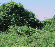
|
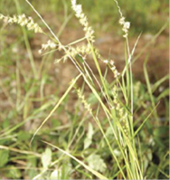
|
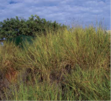
|
|
Caltrop
(Tribulus terrestris)
|
Siratro
(Macroptilium atropurpureum)
|
Gallon’s Curse (Cenchrus
biflorus)
|
Buffel Grass
(Cenchrus ciliaris)
|
|
|
|
|
|
|
|
Figure 5: Examples of key
weed species (Photographs: Shire of Broome, 2016)
Currently
the Shire’s Parks section manages weeds on Shire owned or managed land
and weed management has been supported by a range of groups including Yawuru,
the Shire, Ministry of Justice, Environs Kimberley, PaW, Broome Bird
Observatory, Coastwest (previously Coastcare), Broome Botanical Society,
Conservation Volunteers Australia (CVA), the Society for Kimberley Indigenous
Plants and Animals (SKIPA) and the Kimberley Training Institute.
|
Summary of Management Arrangements for Weeds
|
|
Management objective
|
Ensure
the impact of environmental weeds on the Park is minimised.
|
|
|
|
Priority
|
Lead Agency
|
YCMP Reference
|
|
Management strategies
|
1. Assess current extent and impact of
weeds in the Park.
2. Develop a Weed Management Plan to be
informed, where relevant, by the Shire’s Weed Management Strategy.
|
H
H
|
PaW
PaW
|
3.4
3.10
|
|
Performance Measures
|
1. Weed
mapping outcomes.
2. Development
of Weed Management Plan.
3. Area
and type of weed control completed.
|
|
|
|
|
Targets
|
1. No increase in the abundance,
distribution or extent of priority environmental weeds from current levels.
2. No new populations of
weed species established that are rated high in the Species-led Ranking
Summary for the Kimberley Region.
|
|
|
|
|
Reporting Requirements
|
Every two years
|
|
PaW
|
|
Introduced Fauna Management (KPI)
Feral
animals are non-native species that have the potential to cause a serious
impact on the natural systems through direct effects such as predation, habitat
destruction/degradation, competition for food and territory and introduction of
disease. The main problem feral animals present in the Yawuru Conservation
Estate, including, the Park, are cats and dogs. There is also the potential for
the cane toad to colonise the area within the next ten years (Turpin and
Bamford, 2009), causing detrimental effects to a number of native species and
the values of the reserves. Cats are also common within the Park and hunt and
kill native birds, mammals, reptiles and insects and are a significant threat
to the survival of vulnerable and threatened species (DSEWPC, 2012b). Foxes may
also be present.
Management
of feral animals will be the responsibility of Yawuru and the Shire with the
assistance of Parks and Wildlife, Department of Agriculture and Food, and the
community. The managing agencies will need to determine the extent and impacts
of the problem animals and where appropriate implement control options.
|
Summary of Management Arrangements for Introduced Fauna
|
|
Management objective
|
To
minimise the impact of feral animals on the cultural, ecological and social values
of the Park
|
|
|
|
Priority
|
Lead Agency
|
YCMP Reference
|
|
Management strategies
|
1. Assess current extent and impact of
feral and pest animals in the Park.
2. Consider options for feral and pest
animal control in the Park that are appropriate and supported by the local
community.
|
M
L
|
PaW
PaW
|
3.4
3.4
|
|
Performance Measures
|
1. Assessment of outcomes.
2. Development and implementation of pest
animal control options.
3. Development and availability of
educational material.
|
|
|
|
|
Targets
|
Minimal
impact from feral animals to native fauna and flora within the Park.
|
|
|
|
|
Reporting Requirements
|
Every two years
|
|
PaW
|
|
4.3.2 Fire Management
Fire was
used by the Yawuru people and other indigenous groups for a variety of purposes
including burning for vegetation regrowth (attracting kangaroos and wallabies),
food gathering (judicious fire farming techniques increased supplies of
important plant food), cooking, signalling, access and for cultural reasons
(Kenneally et al, 1996, EPA, 2005, YRNBC, 2011). Traditional burning
practices generally involved small fires, carefully lit in the appropriate
season and in restricted areas. Care was taken to avoid burning in coastal vine
thicket country like that found in Minyirr Park as these areas hold valuable
food resources (Kenneally et al, 1996). Traditional burning promoted a
patchwork mosaic of vegetation growth and also reduced the risk of lightning-ignited
fires developing into intense bushfires. With the departure from traditional
Aboriginal burning practices and they many irreversible modifications to the
environment that have occurred since European colonisation, fire regimes have
changed with large, high intensity, late dry season fires more common (YRNBC,
2011).
Contemporary
fire regimes are believed to have led to impacts on biodiversity, including
sensitive vegetation types and susceptible habits, as well as associated fauna.
Structural simplification of vegetation communities, decline in small mammals
(such as the Golden Bandicoot and water rat), granivorous bird species, weed
infestation and the loss of fine grain habitat mosaics are a number of impacts
associated with changed fire regimes in the Kimberley region (EPA, 2005).
Species and
communities vary in their response to fire. While many species are resilient to
a range of fire regimes, others may have very specific fire requirements (for
example, flora that has relatively long germination periods and fauna that
prefers medium to late successional stages of vegetation). Due to gaps in
current knowledge, fire management for biodiversity conservation should focus
on avoiding frequent, large, hot late dry season fires by creating and maintaining
a spatial and temporal mosaic of functional habitats across the landscape. This
will promote as much resilience as possible for ecosystems in the face of
disturbance. As information from research and monitoring increases (e.g. on the
vital attributes of species and their fire regime requirements), this knowledge
will be incorporated into fire planning and operations.
While there
is limited information currently available on fire regime requirements of
species and communities within the Park, special consideration and further
research should be given to number of key areas:
· fire regeneration cycles in pindan communities;
· effect of fire on mistletoe species; and
· response of threatened flora and fauna (such as
Keraudrenia exastia and the Peregrine Falcon) to fire and fire
management.
Within the
Broome town site, the Shire and Department of Fire and Emergency Services
(DFES) are responsible for bushfire prevention and control, and in establishing
and running the bush fire brigades under the Bush Fires Act 1954. The
Shire is also responsible for serving notices regarding fire breaks and fire
prevention strategies. DFES is responsible for all unvested Crown Land within
the town site. As the Park is now established and vested with Yawuru and the
Shire, the joint managers become responsible for the land and strategic fire
management and mitigation requirements. However, in accordance with the
Assistance Agreement, Parks and Wildlife will undertake fire mitigation work on
behalf of Yawuru and the Shire.
As fire
poses a significant risk to the safety of fire fighters, visitors, neighbours
and local communities as well as a range of community assets, identifying fire
vulnerable community assets within the Park, and determining the risk, likelihood
and consequences of bushfire impact on those assets, will help in the
management and prioritisation of risk mitigation strategies for bushfires. It
is noted that the potential risk of fire in the Park is greatest within areas
of high vegetation density and in areas where there is an understory of weed
species that dry in the summer, such as at Minyirr Park, Bilingurr
(Hidden Valley area), the northern bush blocks situated on the northern town
boundary that form part of the Park and the bush areas inland of Gantheaume
Point Road. Key elements of bushfire risk mitigation include:
· managing fuel levels to reduce the
consequence of unplanned fire events and facilitate more effective fire
response capability,
· maintaining a strategic system of
protective fire breaks,
· maintaining access for fire management,
including tracks suitable for emergency vehicles,
· maintaining fire response/fire
suppression capability, and
· maintaining effective communication with
fire management bodies (DFES, the Shire, PaW) and the local community.
|
Summary of Management Arrangements for Fire Management
|
|
Management objective
|
1. To mitigate the risk of adverse impacts
of bushfire on human life, property and community assets.
2. To promote the maintenance of habitat biodiversity
and the persistence of ‘fire regime specific’ biota and habitats.
|
|
|
|
Priority
|
Lead Agency
|
YCMP Reference
|
|
Management strategies
|
1. Carry out fire risk
assessments in accordance with State Planning Policy 3.7, the State Bushfire
Prone Areas Map and the Bush Fires Act 1954 (WA) (Bush Fires Act).
2. Develop and implement a
Bushfire Mitigation Strategy identifying strategies relating to fuel
reduction burning, provision of access, establishment of strategic fire
breaks and other relevant strategies in liaison with key stakeholders.
3. Maintain best available and up
to date knowledge of fire management in accordance with the Bush Fires Act,
Yawuru traditional knowledge and Shire policies and ensure the ecological and
social values of the Park are included in response plans for fire management
to assist in addressing any significant fire events.
4. Monitor and record the effects
of fire on the most important and vulnerable values and assets, and on
habitats or species which may require specific fire regimes (for example
Monsoonal Vine Thickets, Keraudrenia species etc.).
5. Ensure that Yawuru Rangers are
trained in fire management principles and practices.
|
H
H
H
Ongoing
M
|
PaW
PaW
PaW
PaW
PaW
|
3.4
1.5
2.3
3.4
2.3
|
|
Performance Measures
|
1. Completion
of fire risk assessment.
2. Preparation
of a Bushfire Mitigation Strategy.
3. Implementation
of Bushfire Mitigation Strategy.
4. Outcomes
of monitoring activities.
5. Training
of Yawuru rangers.
|
|
|
|
|
Targets
|
Minimise
impacts associated with fire in the Park.
|
|
|
|
|
Reporting Requirements
|
Annually
|
|
PaW
|
|
4.4 Social and Economic
Values
4.4.1 History and Heritage
Broome and its surrounds,
including the Yawuru Conservation Estate, are exceedingly rich with history and
multilayered cultural heritage. Thousands of years of Aboriginal occupation and
the arrival of pearlers, pastoralists and other settlers, which led to the
evolution of the pearling and pastoral industries and the establishment of the
town of Broome, are defining influences in the heritage of the region. There
are numerous Aboriginal heritage sites registered under the Aboriginal
Heritage Act 1972 (WA). Parts of the Park are included within the
boundary of the West Kimberley National Heritage Area (DSEWPaC, 2011b).
Archaeology and Aboriginal Heritage
According to Akerman (1975),
the coastal portions of Dampierland Peninsula shows evidence of use and
occupation dominated by the presence of mollusc shells, tools and other
artefacts that are evidence of early Aboriginal activity both before and after
contact with non-Aboriginals. A review of the Aboriginal Heritage Inquiry System
maintained by the Department of Aboriginal Affairs (2016) records a number of
registered Aboriginal sites including along Cable Beach, near Gantheaume Point,
and in the Reddell Beach area. A number of these sites are within or in close
proximity to the Park. However, there are numerous sites that are currently
unregistered.
Early History
Broome has a rich
non-indigenous heritage which commenced in 1699 when William Dampier named
Roebuck Bay after his ship. Little further exploration occurred until late in
1801 when Nicholas Baudin travelled the north-west coast as captain of a French
scientific expedition and named several points along the Kimberly coast
including Gantheaume Point. In the 1870s pearlers travelled to Broome to
explore for rich pearling beds and the Broome pearling industry was launched.
This was a brutal time for the Aboriginal people trapped into pearling labour.
As ‘dress diving’ became practice Aboriginal ‘skin
divers’ slowly declined and the workforce increasingly comprised workers
from the east and southeast Asia. By the late 1890s, approximately 80 percent
of the world’s supply of mother-of-pearl shell originated from Broome.
Heritage
The Broome town site holds a
number of listed heritage sites including the Broome cemetery, Court House,
Museum, Chinatown Conservation Area, a number of churches, Streeters jetty and
several pearling buildings, however there are no listed heritage sites within
the Park (Heritage Council, 2015). There are places which have local historical
significance such as Morgan’s Camp, Demco and Gantheaume Point, and these
places would benefit from heritage protection and interpretation. It is
important to maintain Broome’s seaside heritage and identity with the
coastal environment.
|
Summary of Management Arrangements for History and Heritage
Values
|
|
Management objective
|
Ensure consideration and the protection of cultural heritage
sites and values within the Park.
|
|
|
|
Priority
|
Lead Agency
|
YCMP Reference
|
|
Management strategies
|
1. Identify important
non-indigenous heritage sites.
2. Identify key coastal
Aboriginal heritage sites.
|
M
M
|
Shire
Yawuru
|
1.1
1.1
|
|
Performance Measures
|
1. Identification of non-indigenous
heritage sites.
2. Assessment of key coastal Aboriginal
heritage sites.
|
|
|
|
|
Targets
|
1. Avoid impact to heritage sites.
|
|
|
|
|
Reporting Requirements
|
Every two years
|
|
PaW
|
|
4.4.2 Recreation
Nature-based
recreation and cultural tourism are key attractions within the Kimberley.
Broome offers a variety of attractions for the local community and visitors,
including secluded bays of turquoise waters, rocky shores, intertidal flats,
mangroves, sand dunes and beaches with abundant wildlife. It is recognised that
conservation reserves have the capacity to satisfy an important public demand
for outdoor recreation and nature-based tourism, and in so doing contribute
significantly to the social, psychological, physical and economic wellbeing of
the community (DEC, 2006). Management of use and visitation in the Park will be
guided by the management objectives, strategies and targets in Sections 4 and 5
of this Plan, any zoning implemented, as well as by the provisions of the LA
Act, Local Government Act 1995 (WA), the Shire’s local laws, Wildlife
Conservation Act 1950 (WA) and other governing legislation relating
to terrestrial management. Within this setting, a range of socio-economic
values are recognised and will continue to be consistent with management
targets set for cultural and ecological values in the Park.
There are a
number of recreational areas within the Park including Gantheaume Point,
Minyirr Park and beach access points adjacent to Demco Beach, Simpsons Beach,
Reddell Beach and Entrance Point. Recreation and tourism activities within the
Park include wildlife viewing, walking, nature-based education tours (e.g.
school excursions at Base Camp in Minyirr Park), and recreational fishing on beaches
adjacent to the Park. The Park provides opportunities for sustainable
recreational activities that are consistent with maintaining the cultural and
ecological values of the area.
Wildlife Viewing and Walking
Wildlife
viewing and walking are popular activities throughout Broome and the Park,
particularly along the walk trails in Minyirr Park and the Lurujarri trail.
Minyirr Park, also known as the coastal park, is of great cultural significance
to Yawuru people and sits between Gubinge Road and the sea. The park offers
unique walking and wildlife viewing opportunities with approximately 22
kilometres of walk trails meandering through the dunes, pindan and bushland.
Other
popular sightseeing opportunities include the dinosaur foot prints, Anastasias
Pool and the coastal views around Gantheaume Point. Given the Park’s
proximity to residential areas and use as an access to the beach, dog walking
is also a common activity. This activity is discussed in more detail in further
later in this Section.
Picnicking
Picnicking
is an important recreational activity which brings family and friends together
and often goes hand in hand with fishing and beach trips. Currently within the
Park there are no designated picnic areas; however large shelters and tables
are available at Gantheaume Point, Demco and less formally at Base Camp in
Minyirr Park. There are a number of possible sites within the Park that would
benefit from the establishment of picnic facilities such as the parking areas
at Reddell Beach, Demco Beach, Entrance Point and the Gantheaume Point beach
access area. The facilities may range from a basic table and chair to shelters,
lookout platforms and toilets.
Recreational Fishing
Recreational
fishing is a popular activity along the beaches and creeks adjacent to the
Park, as well as in the Cable Beach intertidal zone reserve and is highly
valued by the local community. Recreational fishing is experiencing significant
growth in the region driven by an increase in resident population and tourists
visiting during the dry season. The majority of recreational fishing within the
Broome town site area occurs on coastal cliffs, beaches and creeks, such as
Gantheaume Point, Reddell Beach, Simpson Beach and Dampier Creek, with fishers
targeting bait fish, birrala
Threadfin Salmon (Polydactylus macrochir), walga
walga Bluenose Salmon (Eleutheronema tetradactylum), Barramundi (Lates
calcarifer), Tripletail (Lobotes surinamensis) and Black Jewfish (Protonibea
diacanthus) (Bennelongia, 2009) Bluebone (Choerodon rubescens) and
other reef fish.
Pedestrian
access for recreational fishing is available throughout the Park, while vehicle
access is provided at several boat ramps within the town. The access to the
section of the beach at Gantheaume Beach used as a boat launching site (south
end of Cable Beach) is through the Park, while boat ramps are at Town Beach,
Entrance Point and the Catalinas. The main pressures associated with
recreational fishing for the adjacent Park are localised impacts associated
with the effects of access on ecological values (i.e. from litter and
disturbance of sensitive habitats).
|
Summary of Management Arrangements for Recreation Values
|
|
Management objective
|
Ensure that recreational activities are supported and managed in
a manner that is consistent with maintaining the ecological and
socio-economic values of the Park.
|
|
|
|
Priority
|
Lead Agency
|
YCMP Reference
|
|
Management strategies
|
1. Maintain the Recreation
Master Plan (RMP).
2. Develop and implement an
Interpretation Plan.
3. Monitor environmental
impacts associated with recreation by developing a database to record this
information on an ongoing basis.
4. Prioritise
and cost infrastructure identified within the RMP.
5. Seek
external funding opportunities for capital works for recreation sites.
6. Conduct a
visitor survey programme to better understand visitor use, numbers and
satisfaction of visitor experience.
|
Ongoing
H
Ongoing
H
Ongoing
H
|
PaW
Yawuru
PaW
PaW
PaW
PaW
|
3.11
1.1
3.4
3.11
3.11
3.4
|
|
Performance Measures
|
1. Updates to the RMP.
2. Preparation of the Interpretation
Plan.
3. Recording outcomes of monitoring and
assessment processes.
4. Setting infrastructure priorities.
5. Identification of suitable funding
options.
6. Completion of visitor survey program.
|
|
|
|
|
Targets
|
Ensure a high
quality recreation experience is provided.
|
|
|
|
|
Reporting Requirements
|
Annually
|
|
PaW
|
|
Dogs
Dog walking
and exercising is a common activity across the Yawuru Conservation Estate, and
particularly within the Park due to its close proximity to the Broome town site
and residential areas. The Shire is responsible for administering and enforcing
the Dog Act 1976 (WA) within the town site. The Act states that a dog
shall not be in a public place unless it is:
a) Held by a person who is capable of controlling
the dog; or
b) Securely tethered for a temporary purpose, by
means of a chain, cord, leash or harness of sufficient strength and not
exceeding the prescribed length.
The Shire
has also specified ‘dog exercise areas’ as being the beach
foreshore within the district with the exception of those areas specified in
the prohibited areas. Within the ‘dog exercising areas’, dogs are
permitted off-leash as long as the owner is within reasonable proximity to the
dog. The owner is also required to carry and be capable of attaching a leash
for the purposes of controlling the dog.
|
Summary of Management Arrangements for Dogs
|
|
Management objective
|
Provide equitable access within the Park for dog owners
|
|
|
|
Priority
|
Lead
Agency
|
YCMP
Reference
|
|
Management strategies
|
1. Use appropriate
signage to advise the community where dogs are allowed and where they are not
permitted.
|
M
|
PaW
|
3.5
|
|
Performance Measures
|
1. Development and installation of
signage.
|
|
|
|
|
Targets
|
Installation
of signage in appropriate locations if not already present.
|
|
|
|
|
Reporting Requirements
|
Every two years
|
|
PaW
|
|
Horses
Horse
riding is also an important recreational activity enjoyed primarily by locals
as well as being associated with the horse racing events at the racecourse
inland of Gantheaume Point. Horse riders make use of the Gantheaume Point Beach
utilising the exercise area described in the Shire’s ‘Horses on
Cable Beach Policy’. The policy states that horses are required to cross
Gantheaume Point Road at the signed horse crossing and use the ‘horse
only’ access/egress point to and from the beach foreshore (Figure 6).
Race horses are only permitted between 1st of April and the 31st of August. All
horses must be granted approval from the Shire and approvals are granted for
one year only. Horses entering the beach exercise area may impact on the values
of the Park if their access is not managed effectively. If horses remain on
designated paths and do not enter sensitive cultural and ecological areas such
as those in the nearby Minyirr Park, then horse riding activities should not
pose a threat to the values of the Park.
Figure 6: Horse
access to Cable Beach
4.4.3 Access
Access Restrictions
At
present, no restricted access areas have been identified within the Park for
Aboriginal cultural and customary purposes. The partners recognise that there
may be areas of cultural heritage significance that require access restrictions
and management in accordance with the Yawuru Cultural Management Plan.
Any future restricted access zones must be agreed upon by all joint management
parties.
Pedestrian Access
Due to
ongoing residential development and the associated increased use of walk trails
such as those in Minyirr Park, many of the existing tracks and walkways,
particularly Nagula trails traversing
the sand dunes, as well as parking facilities need to be upgraded and
stabilised. Particular access ways that require management include:
· beach access path over dunes opposite Murray
Road,
· De Marchi Road and McMahon pathways (pathway
from McMahon oval) and dune crossings;
· pathways, dune crossing and car parking
facilities in the Base Camp area,
· the requirement for an established path way and
dune crossing near the Cable Beach Road West roundabout when further
development occurs,
· pathways around Gantheaume Point,
· access and car parking facilities for the use
of Gantheaume Point Beach (south end of Cable Beach), and
· increased signage and interpretation in Minyirr Park and
other recreational nodes.
Vehicle Access
Existing roads within the Park provide public vehicle access to
recreational use areas. Vehicle access within recreation areas will be further
defined through site-level design. Off road driving is also a popular activity
in Broome particularly on Gantheaume Point Beach and in the Cable Beach
Intertidal zone adjacent to the Park. Some off road driving also occurs around
the sand dunes of Reddell Beach and bollards and large rocks are used to
restrict this activity in these sensitive dunes. Signs are used to depict where driving is prohibited on the beach
and dune systems at Gantheaume Point Beach where vehicles are only allowed for
500 metres up the beach before signs display the prohibition of this activity.
All vehicles entering the Park must be licensed under the Road
Traffic Act 1974 (WA). There are no ‘permitted areas’ for
off-road vehicles under the Control of Vehicles (Off-road Areas) Act 1978 (WA).
Vehicles such as unlicensed off-road motorbikes and dune buggies are not
permitted in the Park. Illegal use of unlicensed off-road vehicles and
indiscriminate use of licensed four-wheel drive vehicles have the potential to
adversely impact the values of the Park. Four-wheel drive vehicles can
potentially access a variety of existing tracks, whilst motor bikes and quad
bikes have the capacity to access a far greater area, including walk trails and
dune systems. Concerns from off road vehicle use include the possible impacts
to beach fauna and flora such as turtles and shore crabs.
Flatback Turtles (Natator depressus) and Green Turtles (Chelonia
mydas) are known to nest along Cable Beach, particularly in the northern
areas inland of Bilingurr and within the intertidal zone. The section of
Cable Beach with the most turtle activity has been the area from the steps of
the surf club and 2.1 kilometres north, which is also the section of beach that
receives the highest level of human activity (Conservation Volunteers
Australia, 2010). Seasonal beach closures to off-road vehicles are already in
place and enforced by the Shire.
Other off-road vehicle use
such as quad bikes and motor bikes occurs in the sand dune system around Bilingurr,
Dampier Creek and the northern bush blocks within the Park. The current use is
unsustainable with significant potential for public safety issues, damage to
vegetation and erosion of the dunes. Existing signage is not effective and an
increased management effort is required to enforce these restrictions, which
may include fencing, barriers, public education and other management methods.
Access for Visitors with Disabilities
The joint management partners wish to improve access to services,
information and facilities for people with disabilities. Disability access
issues will be considered and addressed during detailed recreation site
planning and development. There may be practical constraints in providing
access for people with disabilities to some of the more natural recreation
sites within the Park. However, it will generally be possible to provide
universal access at larger modified sites.
Illegal Camping
Currently in the high season
many campers illegally camp down dirt tracks and sand dunes in the Yawuru
Minyirr Buru Conservation Park, primarily around Reddell and Simpson Beaches.
This results in impacts such as vegetation disturbance and rubbish and requires
ongoing management.
Patrol and Enforcement
Shire Rangers manage and
enforce Broome local laws and local government legislation within the Broome
town site. Within the Park, on ground management and enforcement will be
effected by Shire Rangers and Yawuru Rangers employed by Parks and Wildlife.
This Plan details a range of
strategies relating to the management of human activities within the Park.
While users typically comply with management regulations when they understand
why such controls have been implemented, there is always a need to monitor the
level of compliance and take action to stop inappropriate or illegal behaviour.
To achieve this, an appropriate level of field presence by correctly authorised
Rangers will be necessary to provide information and educational messages, and
where appropriate undertake compliance activities. Users of the area (e.g.
tourism operators and the general community) can also play a key role in
self-regulation and peer surveillance.
The Ranger program for
Yawuru community members includes training towards participants becoming
authorised officers under the Local Government Act 2005 (WA), CALM Act
and the Wildlife Conservation Act 1950 (WA). This will allow Yawuru
Rangers who gain authorisation to undertake patrol and enforcement duties
throughout the Park, specifically in the areas of illegal vehicle use and
illegal camping. Yawuru (trainee) Rangers will need to work with Shire Rangers,
PaW authorised officers and other agencies, such as Fisheries, to gain
experience in patrol and enforcement activities.
|
Summary
of Management Arrangements for Access Management
|
|
Management
objective
|
1. To maintain public access to the Park
in a way that does not compromise the cultural, ecological or socio-economic
values of the Park.
2. To maximise public compliance with
regulations related to the ongoing management of the Park.
|
|
|
|
Priority
|
Lead Agency
|
YCMP
Reference
|
|
Management
strategies
|
1. Map
the locations of all formal and informal access locations in the Park.
2. Consolidate
and formalise access locations, closing surplus access ways with agreement
from YPC.
3. If
required, implement access management arrangements to ensure access to
culturally sensitive areas is managed appropriately, with all access
restrictions to be agreed by YPC.
4. Implement
access restrictions as necessary to protect flora, fauna and ecological
communities, with all restrictions to be agreed by YPC.
5. Implement
strategies as necessary to prevent adverse impacts on the values of the Park
from inappropriate vehicle or pedestrian access,
6. Educate,
mentor and support trainee rangers through working with Shire Rangers, Parks
and Wildlife authorised officers and other agencies to gain experience in
patrol and enforcement activities, to the extent possible within the existing
resources of the Shire and Parks and Wildlife.
7. Develop
and implement a collaborative patrol and enforcement program to:
(a) Ensure
compliance with relevant regulations; and
(b) Maximise
efficiency and effectiveness of patrol and enforcement activities.
8. Apply
culturally appropriate and sensitive management to illegal camping issues
within the Yawuru Minyirr Buru Conservation Park.
9. Facilitate
cross-authorisation of government enforcement officers as appropriate
10. Maintain
a database of compliance statistics and issues.
|
H
M
M
M
M
Ongoing
H
Ongoing
L
L
|
PaW
PaW
Yawuru
PaW
PaW
PaW
PaW
PaW
PaW
PaW
|
3.11
3.11
3.11
3.11
3.11
3.1
3.5
3.11
3.4
|
|
Performance
Measures
|
1. Number
of trained and trainee rangers.
2. Compliance
statistics.
3. Installation
of signage and other management measures.
|
|
|
|
|
Targets
|
1. Decreasing
trend of non-compliance within the Park.
2. Rangers
are working throughout the Park.
3. Completion
of regular and annual inspection and maintenance programs.
|
|
|
|
|
Reporting
Requirements
|
Annually
|
|
PaW
|
|
4.4.4 Visual Amenity
The Park
has very high visual amenity values which are important for Yawuru people and
local residents, and are a major part of the appeal of Broome for visitors. The
Park affords panoramic vistas of unique environments including turquoise
waters, beaches, rocky shores, intertidal flats, mangroves, sand dune systems
and monsoonal vine thickets with abundant wildlife. These attributes can be
enjoyed from the beach, higher vantage points along the coast and inland though
dense thickets and bushland. They also provide commercial value to the tourism
industry (such as charter, caravan and camping operators) as a drawcard for
tourists. Due to the location of the Park being so central to the Broome town
site and port facility, the visual values are not pristine. However, a
significant proportion of the Park is quiet and secluded with limited
infrastructure, subsequently having high visual and tranquillity values.
Management
of landscape quality will focus on identifying areas that have high landscape
value and ensuring that activities do not significantly degrade these values.
Structures
along the coastline also have the potential to degrade the unique values of the
Park. This can include signage, shelters, toilets, picnic areas, lighting,
jetties and other infrastructure which may impede the cultural value, history
and unique nature of the Park. Litter, pollution and the development of roads
and facilities that promote visitation can be a threat to these values.
|
Summary of Management Arrangements for Visual Amenity Values
|
|
Management objective
|
Ensure consideration and the protection of the visual amenity
values within the Yawuru Minyirr Buru Conservation Park
|
|
|
|
Priority
|
Lead
Agency
|
YCMP
Reference
|
|
Management strategies
|
1. Identify the key characteristics and map the spatial extent of
important landscapes.
2. Ensure recreation and commercial activities are consistent with
maintaining the landscape.
3. Minimise visual impacts of structures through appropriate placement,
design and colour of materials used.
|
H
M
M
|
PaW
PaW
PaW
|
1.5
4.4
3.10
|
|
Performance Measures
|
1. Mapping
outcomes.
|
|
|
|
|
Targets
|
1. Visual
amenity considered on an ongoing basis.
|
|
|
|
|
Reporting Requirements
|
Every two years
|
|
|
|
4.4.5 Commercial Activities
Tourism
The Park
provides opportunities for commercial and tourism activities and development.
Broome is an internationally renowned tourist destination and the gateway for
tourists wanting to explore the wider Kimberley region. Tourism Research
Australia statistics indicate the average annual number of over-night visitors
to the Shire of Broome has been increasing over the last decade and the average
annual figure for the year ended December 2014 was approximately 245,000
(Tourism WA, 2015). Growing numbers of tourists are also visiting during the
wet season Man-gala to observe the
vast flocks of migratory shorebirds.
Increasingly,
international and national tourists want to experience an authentic Aboriginal
experience and the indigenous tourism industry is developing at a rapid rate
(WAITOC, 2014). The West Australian Indigenous Tourism Operators Council
(WAITOC) had 78 full members, registered as Indigenous tourism businesses in
2013/14 (WAITOC, 2014). Indigenous tourism opportunities in the Kimberley and around
Broome are significant, and the Park offers an insight into unique natural
experiences of Yawuru culture within easily accessible areas and close to the
Broome town site.
The Park
offers a variety of natural and cultural attractions and opportunities for
visitors to the area, with popular activities including site seeing, beach
walking and wildlife appreciation. Management
strategies for recreation and tourism in the Park will focus on major
activities and proposed recreational sites.
Access tracks including those in Minyirr Park, Demco, Morgan’s
Camp, Simpsons Beach and Reddell Beach have also been identified as requiring
different forms of infrastructure and support. Inappropriate paths and tracks
can be closed and the focus will then be given to the maintaining and upgrading
appropriate access ways.
Each identified recreational area identified within the RMP will have a
site specific plan detailing the site location and specific facilities and
infrastructure proposed. The priority, timing and funding arrangements will be
detailed in each site plan. Base Camp, Youth Camp, Gantheaume Point Beach and
Morgan’s Camp have also been identified as possible commercial nodes.
Cultural Ecological Tourism
Cultural
appreciation is an area of potential growth with both ecological and financial
benefits. Commercial opportunities consistent with the purpose of the Park and
Yawuru Conservation Estate is supported and promoted through the ILUAs and the
JMA. The Yawuru Cultural Management Plan proposes the development of an
Interpretation Plan that will apply across the Park.
The
importance of maintaining Yawuru traditional ecological knowledge and culture
as well as tourism demands for cultural tours and Aboriginal cultural
appreciation has emphasised the benefits to further develop the existing
cultural appreciation infrastructure as well as establishing new sites. The
bush furniture and Yawuru season signage around Base Camp has been highlighted
for upgrade. A boardwalk around Burrgungun
Morgan’s Camp and interpretive signage to speak the history of the place
and the importance of the Mangrove communities for the Yawuru people has also
been proposed.
Nature-based
recreation and tourism has the potential to make an important contribution to protecting
the region’s ecosystems by fostering a greater cultural and environmental
understanding. However, unless carefully managed, visitation and tourism
activities have the potential to cause environmental damage, particularly as
the numbers of visitors continue to increase.
Commercial Activities
Yawuru have
identified that the Park provides opportunities for developing commercial
businesses such as cultural heritage and eco-tourism tours, training
opportunities such as cultural awareness training, cultural workshops,
excursions and field programs (YRNTBC, 2011). It is acknowledged under the JMA
that the Yawuru RNTBC has the first right to take up business and commercial
opportunities in the Conservation Estate. Other operators may also be
interested in developing commercial operations within the Park. All commercial
activities will be assessed in accordance with the agreed protocols. If
commercial opportunities are not progressed by Yawuru, then consideration may
be given to commercial use of the Park by other persons in accordance with
agreed protocols.
Events on the Conservation Estate
In additional to commercial
tourism opportunities, the Park offers the opportunity for events to be held at
various locations by Yawuru people and other persons. Event applications will
be assessed and approved in accordance with agreed protocols.
|
Summary of Management Arrangements for Commercial Activities
|
|
Management objectives
|
1. To ensure that
commercial activities are encouraged and managed in a manner that is
consistent with maintaining the cultural, ecological and social-economic
values of the Park.
2. To maintain the
ecological and socio-economic values of the Park that are important to
commercial operators, through the appropriate management of human based activities
that adversely impact upon these values.
3. To provide
opportunities for Yawuru community and Yawuru RNTBC to develop and operate
commercial businesses consistent with maintaining the values of the Park.
|
|
|
|
Priority
|
Lead
Agency
|
YCMP
Reference
|
|
Management strategies
|
1. Assist Yawuru people
and others to identify areas of commercial opportunity within the Park.
2. Determine and develop
appropriate management protocols for assessment, licencing and management of
commercial activities and events.
3. Approvals issued for
commercial activities and events with appropriate conditions.
4. Provide Yawuru people
with new commercial opportunities in the Park.
|
Ongoing
H
Ongoing
Ongoing
|
Yawuru
Shire
Shire
Yawuru
|
4.4
4.4
4.4
4.1
|
|
Performance Measures
|
1. Commercial operations visitor numbers.
2. Identification of commercial
opportunities and associated management frameworks.
3. Number of Licenses/Permits applied for
and issued.
|
|
|
|
|
Targets
|
All
commercial operators have the required approvals and abide by relevant
conditions.
|
|
|
|
|
Reporting Requirements
|
Every two years
|
|
PaW
|
|
Resource values
The region has identified
(and prospective) mineral, oil and gas resources that are important to the
regional economy. Two petroleum exploration permits apply to the Park
(Landgate, 2015); however, no mining or extraction activities are presently
being undertaken. A number of basic raw materials are located in proximity to
the Park, and include the Broome South Sand, Red Hill Mesand, Beacon Hill and
Broome South Sand.
In recognition of the
natural and cultural values and the management purpose of the Park, it is
preferable that all basic raw materials needed for construction within the Park
(e.g. for the construction of roads and recreation developments) are obtained
from outside the Park, or from areas that are already disturbed or of lower
conservation value.
|
Summary of Management Arrangements for Resource Use
|
|
Management objective
|
To protect the values of the Park from any adverse effects
associated with resource use activities in or near to the Park.
|
|
|
|
Priority
|
Lead
Agency
|
YCMP
Reference
|
|
Management strategies
|
1. Obtain
raw materials for use within the Park from outside the Park, unless any
adverse effects on the natural and cultural values are demonstrated to be
very low and there are no other practical, environmentally or culturally
acceptable alternatives.
2. Ensure
that rehabilitation has been effective by post-rehabilitation monitoring and
evaluation, and implementation of any additional or alternative restorative
works if required.
|
Ongoing
L
|
PaW
PaW
|
3.11
3.11
|
|
Performance Measures
|
1. Decision
making process relating to source of raw materials for use within the Park.
2. Development
and implementation of completion criteria for areas disturbed due to
extraction of raw materials.
|
|
|
|
|
Targets
|
1. Avoid
adverse effects within the Park.
2. Restoration
to equivalent or better condition at the conclusion of raw material
extraction activities.
|
|
|
|
|
Reporting Requirements
|
Every two years
|
|
PaW
|
|
4.5 General Management
Measures
4.5.1 Asset Management
Responsible
asset management will be a key component of the successful management of the
Park. As the day to day managers of the Park, Parks and Wildlife will be the
owner of all assets located within the Park, and under the Assistance
Agreement, will be responsible for ongoing maintenance of these assets.
To help
achieve best practice asset management, an Asset Management Plan will be
developed by Parks and Wildlife and endorsed by the YPC to provide a detailed
understanding of the fixed assets located within the Park, with cultural and
environmental assets described in-line with the Yawuru Cultural Management
Plan. The Asset Management Plan will be configured to be fit for purpose to
provide an overview of current assets, provide technical data and property
details, as well as deliver performance and accountability measures (i.e.
condition and maintenance information) which correspond with YPC agreed
criterion. As a minimum, the
Asset Management Plan will record the locations of:
· significant cultural and heritage sites,
· local roads (sealed and unsealed),
· beach access points, stairs, footpaths,
tracks and trails,
· car parks (both developed and areas
utilised for parking),
· culverts, drains, catchments (stormwater
and sewerage),
· signage,
· open space, and
· buildings and other structures such as
seats, sheds, and shaded areas.
Accordingly, the Asset
Management Plan will assist with providing:
· recognition of cultural heritage values,
· asset locations;
· the current condition of assets;
· when/if assets need to be replaced;
· information/upgrades required to meet
regulatory requirements;
· the level and frequency of asset
maintenance programs; and
· life cycle costs by asset, program and
business activity.
Agreed maintenance and
capital programs may also be generated from the asset register for various
activities including:
· new works;
· industry and community partnerships;
· asset replacement;
· routine maintenance; and
· reactive maintenance.
|
Summary
of Management Arrangements for Asset Management
|
|
Management
objective
|
Ensure assets
within the Park are managed appropriately.
|
|
|
|
Priority
|
Lead
Agency
|
YCMP
Reference
|
|
Management
strategies
|
1. Develop
an Asset Management Plan.
2. Undertake
annual inspections of infrastructure within the Park.
3. Prepare
an annual Capital Works Program based on the Asset Management Plan, to be
approved by the YPC.
|
H
Ongoing
H
|
PaW
PaW
PaW
|
3.11
3.11
|
|
Performance
Measures
|
1. Preparation
and endorsement of Asset Management Plan.
2. Annual
inspection program completed.
3. Preparation
and endorsement of annual Capital Works Programs.
|
|
|
|
|
Targets
|
1. Asset
Management Plan endorsed by the YPC.
2. Annual
Capital Works Programs endorsed by the YPC.
3. Annual
inspection programs completed and results documented.
4. Asset
maintenance and replacement undertaken in accordance with Asset Management
Plan and Capital Works Programs.
|
|
|
|
|
Reporting
Requirements
|
Annually
|
|
PaW
|
|
4.5.2 Waste Management
Parks and
Wildlife will undertake a Park waste management inspection program through
routine patrols to determine the extent of illegal rubbish dumping and waste
product dumping. These inspections will determine the location, quantity and
type of waste that is deposited. The outcomes will contribute to the
development of a Waste Management Plan for the Park, to be presented to the YPC
for approval and implemented by Parks and Wildlife. The Waste Management Plan
will also consider the arrangements for servicing rubbish and dog waste bins
that are adjacent to the Park, which are currently serviced by the Shire.
|
Summary of Management Arrangements for Waste Management
|
|
Management objective
|
To
ensure waste is managed appropriately within the Park.
|
|
|
|
Priority
|
Lead Agency
|
YCMP Reference
|
|
Management strategies
|
1. Develop and implement a Waste Management
Plan.
|
M
|
PaW
|
3.11
|
|
Performance Measures
|
1. Development
and implementation of the Waste Management Plan.
2. Amount
of illegal dumping.
|
|
|
|
|
Targets
|
1. Waste managed appropriately.
2. No illegal dumping of rubbish.
|
|
|
|
|
Reporting Requirements
|
Every two years
|
|
PaW
|
|
4.5.3 Information, Education and Interpretation
The development of an education and interpretation program will increase
public awareness and understanding of conservation, Yawuru people and culture,
and management issues in the Park. This increased understanding will help to
develop a sense of community stewardship which will subsequently lead to better
protection of ecological and cultural values and the responsible management of
social values. An important component of the education and interpretation
program is to promote Yawuru
culture and heritage values. This program will draw heavily on the outcomes and
messages from the Yawuru Cultural Management Plan and other management
plans for the Yawuru Conservation Estate. A
linkage between the Leave No Trace (LNT) principals would be an effective way
to consistently communicate values of the Park. The education and
interpretation program needs to be flexible and applied in ways that maximise
the effectiveness of the program for various sectors and target audiences as
well as working with stakeholders wherever possible.
|
Summary of Management Arrangements for Information, Education
and Interpretation
|
|
Management objective
|
To
enhance community understanding of, and support for, the values of the Park
through education and interpretation programs.
|
|
|
|
Priority
|
Lead Agency
|
YCMP Reference
|
|
Management strategies
|
2. Develop and implement an Integrated
Education and Interpretation Plan to ensure users of the Park understand:
· the importance of the key cultural,
ecological and socio-economic values of the Park as set out in this Plan
· the integration of traditional
ecological knowledge into the management of the Park
· the rights of Yawuru people, as the
recognised traditional owners in and around Broome to enjoy Yawuru country
and maintain their cultural practices
· areas of cultural and historical
significance and culturally appropriate behaviour in these areas
· the flora and fauna that are sensitive
to disturbance (e.g. roosting shorebirds) and appropriate behaviour to
minimise impacts
· the effects of dumping rubbish and
garden refuse and the threat invasive plants pose to the values of the Park
· appropriate behaviours to reduce illegal
vehicle access and camping
· appropriate behaviours to reduce the
risk of injury and ensure public safety.
3. Ensure the education and interpretation
program for the Park is appropriately integrated with relevant outcomes and
messages from the Cultural Management Plan and other management plans
for the Conservation Estate.
4. Ensure that Yawuru people have an active
role in the education and interpretation programs.
5. Install culturally appropriate signage
for the Park for educational purposes where appropriate, and with approval
from the YPC and consistent with the Interpretive Plan
6. Encourage and assist the tourism
industry to provide educational courses/materials to their staff and
customers to foster community stewardship of the Park.
7. Develop promotional and educational
material.
|
H
M
H
H
L
Ongoing
|
Yawuru
Yawuru
Yawuru
PaW
Yawuru
Yawuru
|
1.1
5.1
1.1
5.1
|
|
Performance Measures
|
3. Development
and implementation of Education and interpretation Plan.
4. Visitor
and industry surveys.
5. Promotional
and educational materials produced.
|
|
|
|
|
Targets
|
3. Fifty percent of visitors to the Park
are aware of the existence of the Park, its values and the management
requirement that apply within five years of the release of the Plan.
|
|
|
|
|
Reporting Requirements
|
Every two years
|
|
PaW
|
|
4.5.4 Public Participation
Public
participation can help to build and sustain community support that is critical
for effective implementation of this Plan. This can be achieved in a number of
ways including advisory committees, community forums, surveys, and information
events. Given the unique circumstances (i.e. a number of individual management
plans and a variety of vesting arrangements), it will be necessary to consider
carefully how best to achieve public participation in management of all the
Yawuru Conservation Estate, including the Park.
Groups and
organisations including the Yawuru RNTBC, NBY, the Shire, Roebuck Bay Working
Group (RBWG) Environs Kimberley, Parks and Wildlife, Broome Bird Observatory,
Coastwest, Broome Botanical Society, Conservation Volunteers Australia, SKIPA,
Ministry of Justice, Kimberley Training Institute and local business, as well
the wider community, have already established strong working partnerships which
have been integral in previous conservation programs. There is also an
opportunity to consider the role of cultural caretakers in areas of special
significance such as Morgan’s Camp and Minyirr Park.
|
Summary of Management Arrangements for Public Participation
|
|
Management objective
|
To
encourage and facilitate ongoing public participation in the management of
the Park.
|
|
|
|
Priority
|
Lead Agency
|
YCMP Reference
|
|
Management strategies
|
1. Consider and
establish appropriate structures and mechanisms to provide for community
input and involvement in ongoing management of the Park.
2. Develop and implement
a public participation program for the Park which encourages community
involvement through a range of opportunities, including education and
monitoring programs.
3. Maintain records of
public participation.
|
H
M
L
|
PaW
PaW
PaW
|
3.10
3.6
3.4
|
|
Performance Measures
|
1. Development of
community involvement
mechanisms.
2. Development
and implementation of the public participation program.
3. Development
of the public participation records database.
|
|
|
|
|
Targets
|
To
facilitate ongoing public participation in the management of the Park.
|
|
|
|
|
Reporting Requirements
|
Annually
|
|
PaW
|
|
4.5.5 Research and Monitoring
The nature
and diversity of habitats in the Park combined with the proximity to the Broome
town site provide unique opportunities for ecological, cultural,
archaeological, geomorphological and socio-economic research, with close
community involvement and participation. A
good understanding of the cultural values and ecology of the Park and knowledge
about the cumulative long-term impact of recreational and commercial activities
on these values are fundamental requirements for effective management. There
has been a significant amount of research characterising the Broome wetlands,
mangroves, intertidal flats and migratory shorebirds, however this large body
of work remains to be collated and synthesised in a coherent and systematic
manner to realise its full potential for long term management. Recent research
initiatives have been developed through various community groups, academic
institutions and environmental government and non-government organisations,
focusing on research projects such as the monsoonal vine thickets, significant
flora of the region, Snubfin Dolphins and Flatback Turtle nesting.
All research within the Park
requires Yawuru and Shire approval and the appropriate research permit and/or
approvals issued under the Local Government Act 2005 (WA), Wildlife
Conservation Act 1950 (WA), Fish Resources Management Act 1994 (WA),
EPBC Act and/or the Animal Welfare Act 2002 (WA), as relevant to the
research proposal. Special access requirements may be necessary for research
into areas with restricted access.
|
Summary of Management Arrangements for Research and Monitoring
|
|
Management objectives
|
To
provide access and opportunities for scientific research in the Park.
|
|
|
|
Priority
|
Lead Agency
|
YCMP Reference
|
|
Management strategies
|
1. Encourage
and facilitate as far as practicable community and other involvement in
research and monitoring programs, providing financial and logistical
assistance where possible.
|
L
|
PaW
|
5.1
|
|
Performance Measures
|
1. Involvement
of various organisations in research projects.
|
|
|
|
|
Targets
|
Increased
knowledge of the various values within the Park.
|
|
|
|
|
Reporting Requirements
|
Every two years, or in accordance with
research project timetables.
|
|
PaW
|
|
4.5.6 Risk Management and Safety
Risks to
public safety within the Park include:
• the
possibility of sudden pindan cliff collapses should visitors stray from formal
lookouts, recreation areas and walking trails
• weather
events such as cyclones and severe storms
• some
marine and coastal fauna (e.g. crocodiles, irukandji jellyfish)
• ongoing
erosion caused by coastal processes.
Yawuru people view
transgressions against the law as a cause of natural disasters and human
tragedies and take seriously their cultural duty to ensure that Yawuru
community members and ‘strangers’ do not place themselves and
others at risk of harm. Yawuru cultural protocols include protocols that help
Yawuru people fulfil their cultural responsibilities to look after anyone on
Yawuru country e.g. protocols about access to culturally sensitive areas that
Yawuru people believe are subject to powerful and dangerous forces (Yawuru
RNTBC 2011).
A risk assessment and risk
management plan will be developed by Parks and Wildlife for the Park, comprising
identification, analysis and efficient control of exposure to public liability
risks.
|
Summary of Management Arrangements for Risk Management and
Safety
|
|
Management objective
|
To minimise risks to visitors within the Yawuru Minyirr Buru
Conservation Park from natural and other hazards.
|
|
|
|
Priority
|
Lead Agency
|
YCMP
Reference
|
|
Management strategies
|
1. Undertake a biannual risk assessment and develop
a risk management plan to identify hazards/risks and proposed corrective/
mitigation actions.
2. Identify the estimated costs associated with each
proposed corrective action.
3. Consider the recommendations of the Broome
Townsite Coastal Hazard Risk Management and Adaptation Plan (CHRMAP) in
undertaking the risk assessment and implementing the risk management plan.
|
H
H
H
|
PaW
PaW
PaW
|
3.10
3.10
|
|
Performance Measures
|
1. Identification and prioritisation of risks.
2. Implementation of management strategies.
|
|
|
|
|
Targets
|
3. No
serious injuries reported in the Park.
|
|
|
|
|
Reporting Requirements
|
Annually
|
|
PaW
|
|
5.0 Yawuru Language Glossary
|
balyjarr
|
saltwater
couch (Sporobolus virginicus)
|
|
Barrgana
|
Yawuru season:
cold season, May
|
|
bilarra
|
wetland/spring
|
|
bilgin
|
Water chestnut
(Eleocharis dulcis)
|
|
birra
|
bush; bush
country, inland country
|
|
biyal-biyal
|
kapok mangrove
(Camptostemon schultzii)
|
|
Bugarrigarra
|
the Dreaming;
Dreamtime; history before time began; derived from bugarri = dream and garra
= more than one
|
|
bundu
|
salt marsh
(saline grasslands, samphire, mudflats)
|
|
Bundurr-bundurr
|
the red
sandplains and vegetation known as ‘pindan’
|
|
buru
|
one’s
country; traditional country; land/earth/dirt/ground; can also mean
time/place/season
|
|
galji
|
the
fine-grained soft carbonate mud that occurs around Broome
|
|
garl-garl
|
‘blind
your eye’ mangrove or milky mangrove (Excoecaria agallocha), which has
a blinding sap
|
|
girrbaju
|
bush honey;
sugar bag
|
|
gudurrwarany
|
brolga (Grus
rubicunda)
|
|
gundurung
|
Mangrove; and
also in particular the light green leaf white mangrove (Avicennia marina)
|
|
gurlju buru
|
saline
grassland/grassland
|
|
jarrmirdany
|
corkscrew
Pandanus (Pandanus spiralis)
|
|
jigily
|
Kimberley
bauhinia (Bauhinia cunninghamii)
|
|
jila
|
‘living
water’; permanent freshwater sources
|
|
jurru
|
mystical being;
serpent-like figure; snake
|
|
Laja
|
Yawuru season:
late October/November-December
|
|
langurr
|
northern
nail-tail wallaby (Onychogalea unguifera)
|
|
liyan
|
feelings that
express emotional strength, dignity and pride
|
|
Man-gala
|
Yawuru season:
December to March, wet season
|
|
Marrul
|
Yawuru season:
April to May
|
|
mayi
|
bush foods;
bush fruit
|
|
Murrga-yirr-garnburr
|
melaleuca
thicket
|
|
nagula
|
ocean; sea
country
|
|
nirliyangarr
|
dune wattle
(Acacia bivenosa)
|
|
niyamarri
|
beaches and
dunes
|
|
rarrga-rarrga
|
beach spinifex
(Spinifex longifolius)
|
|
rayi
|
spiritual
essence; spirit being; child-spirit
|
|
rirrwal
|
white dragon
tree (Sesbania formosa)
|
|
Wirralburu
|
Yawuru season:
warming up season; September to October
|
|
Wirn-gi
|
samphire;
saltbush (Frankenia ambita)
|
|
Wirralburu
|
Yawuru season:
May
|
|
|
|
Source: Yawuru cultural
management plan (Yawuru RNTBC 2011)
6.0 References
Aboriginal Heritage Act
1972 (WA)
Aboriginal Heritage Inquiry
System, 2016, Registered Sites, Shire of Broome, accessed July 2016 from
http://maps.dia.wa.gov.au/AHIS2/.
Akerman, K., 1975,
Aboriginal Camp Sites on the Western Coast of Dampierland, Western Australia,
in Occasional Papers in Anthropology No 4, March 1975, pp 93 –
104, University of Queensland.
Animal Welfare Act 2002 (WA)
Atlas of Living Australia,
2015, Pterocaulon intermedium, viewed October 2015 http://bie.ala.org.au/species/Pterocaulon+intermedium.
Australian Museum 2010, Online
Information about the Estuarine Crocodile, September 2010, Australian
Museum 2012, viewed 14 February 2012, http://australianmuseum.net.au/estuarine-crocodile.
Beams, L., Docherty, P., and
Dureau, D., 2011, Preliminary Plant Community Description – Mangarr
Community on Relict Dune Systems, Broome Peninsula. Broome, Western
Australia.
Bennelongia 2009, Ecological
character description for Roebuck Bay, Report to the Department of
Environment and Conservation, Bennelongia Pty Ltd, Jolimont, Western Australia.
Biosecurity
and Agriculture
Management Act 2007 (WA)
Black, SJ, Willing, T &
Dureau, DM, 2010, A Comprehensive Survey of the Flora, Extent and Condition
of Vine Thickets on Coastal Sand Dunes of Dampier Peninsula, West Kimberley
2000–2002, Broome Botanical Society (Inc.), Broome, Western
Australia.
BOM – see Bureau of
Meteorology
Bureau of Meteorology, 2015,
Climate Data Online – Broome Airport, Station ID 003003, viewed
October 2015 http://www.bom.gov.au/climate/data/index.shtml?bookmark=200.
Bush Fires Act 1954 (WA)
Conservation Volunteers
Australia, 2010, Cable Beach Community-based Monitoring Program –
Report of 2009 – 10 Nesting Activity for the Flatback Turtle (Natator
depressus) at Cable Beach, Western Australia, Conservation Volunteers
Australia, Broome, Western Australia.
Conservation and Land
Management Act 1984
(WA)
Control
of Vehicles (off-Road Areas) Act 1978 (WA)
DEC – see
Department of Environment and Conservation
Department of Agriculture
and Food WA 2015, Western Australian Organism List (WAOL), viewed
October 2015 https://www.agric.wa.gov.au/bam/western-australian-organism-list-waol.
Department of Conservation
and Land Management, 1999, Environmental Weed Strategy for Western Australia,
viewed October 2015, http://www.PaW.wa.gov.au/images/documents/plants-animals/plants/weeds/environmental_weed_strategy_wa.pdf.
Department of Environment
and Conservation, 2006, Policy Statement No. 18 – Recreation,
Tourism and Visitor Services, Perth, Western Australia.
Department of Parks and
Wildlife, 2015a, NatureMap: Mapping Western Australia’s Biodiversity, Department
of Environment and Conservation, Perth, viewed August 2015, www.naturemap.PaW.wa.gov.au/.
Department of Parks and
Wildlife, 2015b, Threatened and Priority Ecological Community Lists,
June 2015, viewed October 2015, http://www.PaW.wa.gov.au/plants-and-animals/threatened-species-and-communities/wa-s-threatened-ecological-communities.
Department of Sustainability,
Environment, Water, Population and Communities 2011a, National Heritage
Places – West Kimberley, Commonwealth of Australia, viewed 7 February
2011, http://www.environment.gov.au/heritage/places/national/west-kimberley.
Department of
Sustainability, Environment, Water, Population and Communities 2011b, West
Kimberley Place Report – Description and History Prepared for the
Australian Heritage Council’s Final Assessment of National Heritage
Values, Commonwealth of Australia, viewed 1 June 2012, www.environment.gov.au/heritage/places/national/west-kimberley/index.html.
Department of
Sustainability, Environment, Water, Population and Communities 2012a, Ctenotus
angusticeps, in Species Profile and Threats Database, Commonwealth of
Australia, viewed 5 June 2012, www.environment.gov.au/sprat.
Department of
Sustainability, Environment, Water, Population and Communities 2012b,
Rostratula australis, in Species Profile and Threats Database, Commonwealth
of Australia, viewed 5 June 2012 from www.environment.gov.au/sprat.
Department of the
Environment, 2015a, The West Kimberley, Great Northern Hwy, Broome, WA,
Australia, viewed 20 August 2015, http://www.environment.gov.au/cgi-bin/ahdb/search.pl?mode=place_detail;place_id=106063.
Department of the
Environment, 2015b, Weeds of National Significance, viewed October 2015,
https://www.environment.gov.au/biodiversity/invasive/weeds/weeds/lists/wons.html.
Department of Water 2010a, Kimberley
Regional Water Plan 2010–2030: Strategic Directions and Actions –
Draft for Public Comment, Department of Water, Perth.
Department of Water 2010b, La
Grange Groundwater Allocation Plan, Water Resource Allocation and Planning
Series, Report no. 25 February 2010, Department Water, Perth.
Department of Water 2012, Groundwater
Resource Review, Dampier Peninsula, Hydrogeological Record Series, Report
no. HG57, Department of Water, Perth.
Dog Act 1976 (WA)
DotE – see Department
of the Environment
DOW – see
Department of Water
DSEWPC – see
Department of Sustainability, Environment, Water, Population and Communities
Eliot, I., and Eliot, M.
2008. Coastal Geomorphology: Proposed LNG Hub Locations in Kimberley Region
of Western Australia. Report for Northern Development Taskforce: Environmental
Experts Working Group. Damara WA Pty Ltd. Innaloo. Western Australia.
Environment Protection
and Biodiversity Conservation Act 1999
(Cwlth)
Environmental Protection
Authority, 2005, Fire in the Kimberley and Inland Regions of WA,
Environmental Protection Authority, Perth, Western Australia,
Fish
Resources Management Act 1994 (WA)
Foster-Smith,
J., Birchenough, A., Evans, S., and Prince, J., 2007, Human Impacts on Cable
Beach, Broome Western Australia, in Journal of Coastal Management,
35:181 – 194.
Graham. G., (2001),
Dampierland 2 (DL2 Pindanland Subregion), in May J. (Ed.), A Biodiversity
Audit of Western Australia’s Biogeographical Subregions in 2002.
Department of Conservation and Land Management, Perth, Western Australia.
Heritage Council, 2015, State
Heritage Register, viewed October 2015, http://stateheritage.wa.gov.au/state-heritage-register.
Johnstone, R., 1983,
‘Birds’, in McKenzie, N., (Ed), Wildlife of the Dampier
Peninsula, South-west Kimberley, Western Australia, Wildlife Research
Bulletin Western Australia, part V, no. 11, pp. 54–69, Department of
Fisheries and Wildlife, Perth, Western Australia.
Kenneally, K., Edinger, D.,
& Willing, T, 1996, Broome and Beyond–Plants and People of the
Dampier Peninsula, Kimberley, Western Australia, Department of Conservation
and Land Management, Perth.
Land Administration Act
1997 (WA)
Landgate, 2015, WA Atlas
– Minedex and WA Petroleum Titles, viewed October 2015 https://www2.landgate.wa.gov.au/bmvf/app/waatlas/.
Laws, A.’, 1991,
‘Explanatory notes on the Broome 1:250 000 hydrogeological sheet’, Geological
Survey of Western Australia Hydrogeological Series–Explanatory Notes, Department
of Mines Western Australia.
Local Government Act 2005 (WA)
Matthews, D., Semeniuk, V,
and Semeniuk, C, 2011, Freshwater Seepage along the Coast of the Western Dampier
Peninsula, Kimberley Region, Western Australia, in Journal of the Royal
Society of Western Australia, Vol. 94, Pt 2, pp. 207 – 212.
McKenzie, N., (ed.) 1983, Wildlife
of the Dampier Peninsula, South-west Kimberley, Western Australia, Wildlife
Research Bulletin Western Australia, no. 11, pp. 1–83, Department of
Fisheries and Wildlife, Perth.
McKenzie N & Burbidge,
A., 2002, Australian Mammal Audit, in WATSNU – Newsletter for
Threatened Species and Ecological Communities, Conservation, vol. 9 no. 1,
pp.4–7, Department of Environment and Conservation, Perth.
National Native Title
Tribunal 2010a, Yawuru Area Agreement ILUA, Register of Indigenous Land
Use Agreements, Commonwealth of Australia 2008-2011, viewed 8 February 2012, www.nntt.gov.au.
National Native Title
Tribunal 2010b, Yawuru Prescribed Body Corporate ILUA - Broome, Register
of Indigenous Land Use Agreements, Commonwealth of Australia 2008–2011,
viewed 8 February 2012, www.nntt.gov.au.
National Native Title
Tribunal 2010c, The Yawuru people’s native title journey, Talking
Native Title online newsletter, Commonwealth of Australia 2008–2011,
viewed 8 February 2012, www.nntt.gov.au.
Native Title Act 1993 (Cwlth)
NatureMap – see Parks
and Wildlife
Oldmeadow, E., 2007, ‘Geological
and Hydrogeochemical Investigations into the Holocene Carbonate Dominated
Wetlands, Roebuck Bay and Roebuck Plains, Western Australia’, PhD
Dissertation (Applied Geology), Curtin University of Technology, Western
Australia.
Parks and Reserves Act
1895 (WA)
PaW – see Department
of Parks and Wildlife
Pepping, M., Piersma, T.,
Pearson, G., and Lavaleye, M. (1999). Intertidal Sediments and Benthic
Animals of Roebuck Bay, Western Australia. Texel, The Netherlands:
Netherlands Institute for Sea Research (NIOZ).
Piersma, T,
Pearson, GB, Hickey, R, Dittmann, S, Rogers, DL, Folmer, E, Honkoop, P, Drent,
J, de Goeij, P, and Marsh, L, 2006, Research Report – Roebuck Bay
Invertebrate and Bird Mapping 2006, viewed October 2015, http://www.rug.nl/research/animal-ecology/publications/_pdf/_2006/4piersma06.pdf.
Road Traffic Act 1974 (WA)
Roebuck Bay
Working Group Inc., (undated), Creepy Crawlies and Mud, viewed October
2015, http://www.roebuckbay.org.au/our-bay/creepy-crawlies-and-mud/.
Searle, JA, 2012, Groundwater
Resource Review, Dampier Peninsula, Hydrogeological Record Series,
Report no. HG57, Department of Water, Perth.
Semeniuk Research Group,
2011, The Wetlands of the Yawuru Coastal Country, Broome Regional Area: The
Coastal Wetlands, Stratigraphy and Hydrology, Natural Maintenance,
Environmental and Geoheritage Significance, and Recommendations for Management,
Report to Nyamba Buru Yawuru Ltd.
Semeniuk, V, 2008, ‘Holocene
Sedimentation, Stratigraphy, Biostratigraphy, and History of the Canning Coast,
North-western Australia’, Journal of the Royal Society of Western
Australia, Supplement to vol. 91, Part 1, pp. 53–148, Royal Society
of Western Australia, Perth.
Semeniuk, V., 1983, Regional
and Local Mangrove Distribution in Northwestern Australia in Relationship to
Freshwater Seepage, in Vegetation 53:11 – 31.
Shire of Broome, 2016,
personal communication.
Storr, G., and Johnstone,
R., 1983, ‘Amphibians and Reptiles’, in McKenzie, N., (ed.) Wildlife
of the Dampier Peninsula, South-west Kimberley, Western Australia, Wildlife
Research Bulletin Western Australia, Part VI, no. 11, pp. 70–74,
Department of Fisheries and Wildlife, Perth.
Storr, G., Smith, L., and Johnstone,
R., 2002, Snakes of Western Australia, Western Australian Museum, Perth.
Tourism Western Australia
2015, Australia’s North West – Overnight Visitor Fact Sheet Year
Ending December 2014, viewed October 2015, http://www.tourism.wa.gov.au/Publications%20Library/Research%20and%20reports/Australia%27s%20North%20West%20YE%20Dec%202014%20Factsheet.pdf.
Trudgen, M., 2002, A
Flora, Vegetation and Floristic Survey of the Burrup Peninsula, some Adjoining
Areas and part of the Dampier Archipelago with Comparisons to the Florists of
Areas on the Adjoining Mainland (Volume 1), ME Trudgen and Associates, Consultant
Botanists, unpublished report prepared for the Department of Mineral and
Petroleum Resources, Perth Western Australia.
Turpin, J., and Bamford, M.,
2010, Fauna Assessment of the Broome Port Area, report prepared for
Coffey Natural Systems by M.J. and A.R. Bamford, Consulting Ecologists,
Kingsley, Western Australia.
Vogwill, R., 2003, Hydrogeology
and Aspects of Environmental Geology of the Broome Area, Western Australia,
PhD Dissertation (Applied Geology), Curtin University of Technology, Western
Australia.
WAITOC 2014, 2013 –
2014 WAITOC Annual Report, viewed October 2015, http://www.waitoc.com/2014/waitoc-corporate-documents.
Waples K, 2007, Kimberley
Biodiversity Review, Department of Environment and Conservation, Perth.
Water and Rivers Commission
(WRC), 2001, Broome Water Reserve Water Source Protection Plan, Broome Town
Water Supply, Waters and Rivers Commission Water Resource Protection
Series Report No. WRP41. Waters and Rivers Commission Policy and Planning
Division, Perth. Western Australia.
Western Australian
Department of Planning and Urban Development (WADPUD), 1990, Cable
Beach/Reddell Point Broome Development Concept Plan, Western Australian
Department of Planning and Urban Development, Perth, Western Australia.
Wildlife Conservation Act
1950 (WA)
Yawuru – www.yawuru.com, accessed October 2015
Yawuru Registered Native
Title Body Corporate, 2011, Walyjala-jala buru jayida jarringgun buru Nyamba
Yawuru ngan-ga mirli mirli (Planning for the Future: Yawuru Cultural Management
Plan) – the cultural management plan for Yawuru coastal country and
the Yawuru Conservation Estate, Pindan Printing Pty Ltd, Broome, Western
Australia.
YRNTBC 2011-see
Yawuru Registered Native Title Body Corporate, 2011
Copies of the Yawuru
cultural management plan are available from:
Nyamba Buru Yawuru
PO Box 425, Broome, WA, 6725
yawuru@yawuru.org.au
7.0 Acronyms
|
ANZECC
|
Australia and
New Zealand Environment and Conservation Council
|
|
BBO
|
Broome Bird
Observatory
|
|
BF Act
|
Bush Fires Act
1954 (WA)
|
|
BPA
|
Broome Port
Authority
|
|
CALM Act
|
Conservation
and Land Management Act 1984 (WA)
|
|
CAMBA
|
China-Australia
Migratory Bird Agreement
|
|
CCWA
|
Conservation
Commission of Western Australia
|
|
CVA
|
Conservation
Volunteers Australia
|
|
DFES
|
Department of
Fire and Emergency Services (formerly Fire and Emergency Services Authority)
|
|
PaW
|
Department of
Parks and Wildlife (known as Parks and Wildlife; formerly Department of
Environment and Conservation)
|
|
DoF
|
Department of
Fisheries
|
|
DMP
|
Department of
Mines and Petroleum
|
|
DoT
|
Department of
Transport
|
|
DoP
|
Department of
Planning
|
|
EP Act
|
Environmental
Protection Act 1986 (WA)
|
|
EPBC Act
|
Environment
Protection and Biodiversity Conservation Act 1999 (Cwlth)
|
|
EPA
|
Environmental
Protection Authority
|
|
FRM
|
Fish Resource
Management Act 1994 (WA)
|
|
H
|
High priority management
strategy
|
|
H-KMS
|
High key
management strategy
|
|
ILUA
|
Indigenous
Land Use Agreement
|
|
IPA
|
Indigenous
protected area
|
|
IUCN
|
International
Union for the Conservation of Nature
|
|
JAMBA
|
Japan-Australia
Migratory Bird Agreement
|
|
JMA
|
Joint
Management Agreement
|
|
KPI
|
Key
performance indicator
|
|
KTI
|
Kimberley
Training Institute
|
|
LA Act
|
Land
Administration Act 1997 (WA)
|
|
LG Act
|
Local
Government Act 1995 (WA)
|
|
L-KMS
|
Low priority
key management strategy
|
|
LNT
|
Leave no trace
|
|
M-KMS
|
Medium
priority key management strategy
|
|
MOU
|
Memorandum of
understanding
|
|
MPRA
|
Marine Parks
and Reserves Authority
|
|
NT Act
|
Native Title
Act 1993 (Cwlth)
|
|
PEC
|
Priority
ecological community
|
|
RNTBC
|
Registered
Native Title Body Corporate
|
|
ROKAMBA
|
Republic of
Korea-Australia Migratory Bird Agreement
|
|
SKIPA
|
Society for
Kimberley Indigenous Plants and Animals
|
|
SoB
|
Shire of
Broome
|
|
TEC
|
Threatened
ecological community
|
|
TEK
|
Traditional
ecological knowledge
|
|
UCL
|
Unallocated
crown land
|
|
WAM
|
Western
Australian Museum
|
|
WADPUD
|
West Australian
Department of Planning and Urban Development (now Department of Planning)
|
|
WC Act
|
Wildlife
Conservation Act 1950 (WA)
|
|
WRC
|
Water and
Rivers Commission
|
|
YCE
|
Yawuru
Conservation Estate
|
|
YCMP
|
Yawuru
Cultural Management Plan
|
|
YPC
|
Yawuru Park
Council
|
|
|
|
|
|
|
Appendix 1 – Tenure of
Reserves within Yawuru Minyirr Buru Conservation Park
|
Map No.
|
ILUA Area
|
Lot Details
|
Reserve No.
|
Class
|
Management Order
|
Purpose
|
Spatial Area (ha)
|
|
|
Town site Areas (Yawuru Prescribed Body Corporate ILUA)
|
|
|
1
|
Area 1, Schedule 9
|
Lot
450 on DP 72928
|
51115
|
A
|
Care,
control and management to Yawuru RNTBC and the Shire of Broome
|
Conservation,
recreation, and traditional and customary Aboriginal use and enjoyment
|
144.1953
|
|
2
|
Area 2, Schedule 9
|
Lot
520 on DP 71094
|
50994
|
A
|
Care,
control and management to Yawuru RNTBC and the Shire of Broome
|
Conservation,
recreation, and traditional and customary Aboriginal use and enjoyment
|
294.83
|
|
3
|
Area 2.5, Schedule 9
|
Lot
301 on DP 71518
|
50994
|
A
|
Care,
control and management to Yawuru RNTBC and the Shire of Broome
|
Conservation,
recreation, and traditional and customary Aboriginal use and enjoyment
|
165.36
|
|
4
|
Area 3, Schedule 9
|
Lot
601 on DP 70309
|
51106
|
C
|
Care,
control and management to Yawuru RNTBC and the Shire of Broome
|
Conservation,
recreation, and traditional and customary Aboriginal use and enjoyment
|
268.48
|
|
5
|
Area 4, Schedule 9
|
Lot
400 on DP 70309
|
51106
|
C
|
Care,
control and management to Yawuru RNTBC and the Shire of Broome
|
Conservation,
recreation, and traditional and customary Aboriginal use and enjoyment
|
22.314
|
|
6
|
Area 5, Schedule 9
|
Lot
450 on DP 72936
|
51304
|
A
|
Care,
control and management to Yawuru RNTBC and the Shire of Broome
|
Conservation,
recreation, and traditional and customary Aboriginal use and enjoyment
|
63.519
|
|
7
|
Area 6, Schedule 9
|
Lots
560 and 562 on DP 71526
|
52308
|
C
|
Care,
control and management to Yawuru RNTBC and the Shire of Broome
|
Conservation,
recreation, and traditional and customary Aboriginal use and enjoyment
|
20.851
|
|
8
|
Area 7, Schedule 9
|
Lot
602 on DP 70310
|
51106
|
C
|
Care,
control and management to Yawuru RNTBC and the Shire of Broome
|
Conservation,
recreation, and traditional and customary Aboriginal use and enjoyment
|
1.3650
|
|
9
|
Area 9, Schedule 9
|
Lots
521, 524 and 525 on DP 71095
|
50994
|
A
|
Care,
control and management to Yawuru RNTBC and the Shire of Broome
|
Conservation,
recreation, and traditional and customary Aboriginal use and enjoyment
|
8.7476
|
|
10
|
Area 10, Schedule 9
|
Lot
560 on DP 72599
|
51176
|
A
|
Care,
control and management to Yawuru RNTBC and the Shire of Broome
|
Conservation,
recreation, and traditional and customary Aboriginal use and enjoyment
|
3.3342
|
|
11
|
Area 12, Schedule 9
|
Lot
389 on DP 72932
|
51114
|
C
|
Care,
control and management to Yawuru RNTBC and the Shire of Broome
|
Conservation,
recreation, and traditional and customary Aboriginal use and enjoyment
|
247.916
|
|
12
|
Area 13
“Port Excision Area”, Schedule 9
|
Lot
603 on DP 70311
|
51001
|
C
|
Care,
control and management to Yawuru RNTBC and the Shire of Broome
|
Conservation,
recreation, and traditional and customary Aboriginal use and enjoyment
|
12.886
|
|
13
|
Area 14
“Port Excision Area”, Schedule 9
|
Lot
620 on DP 70861
|
51001
|
C
|
Care,
control and management to Yawuru RNTBC and the Shire of Broome
|
Conservation,
recreation, and traditional and customary Aboriginal use and enjoyment
|
10.406
|
|
14
|
Area 14a
“Port Excision Area”, Schedule 9
|
Lot
622 on DP 70861
|
51001
|
C
|
Care,
control and management to Yawuru RNTBC and the Shire of Broome
|
Conservation,
recreation, and traditional and customary Aboriginal use and enjoyment
|
1.0427
|
|
15
|
Area 15
“Port Excision Area”, Schedule 9
|
Lot
623 on DP 70861
|
51001
|
C
|
Care,
control and management to Yawuru RNTBC and the Shire of Broome
|
Conservation,
recreation, and traditional and customary Aboriginal use and enjoyment
|
13.781
|
|
|
Town site Areas (Yawuru Area Agreement ILUA)
|
|
16
|
Part 2(a), Schedule 7
|
Lot
750 on DP 75607
|
51901
|
A
|
Care,
control and management to Yawuru RNTBC and the Shire of Broome
|
Conservation,
recreation, and traditional and customary Aboriginal use and enjoyment
|
5.3854
|
|
17
|
Part 2(a) Schedule 7
|
Lot
1195 on DP 181457
|
51106
|
C
|
Care,
control and management to Yawuru RNTBC and the Shire of Broome
|
Conservation,
recreation, and traditional and customary Aboriginal use and enjoyment
|
3.4317
|
|
18
|
Part 2(a) Schedule 7
|
Lot
561 on DP 71526
|
52308
|
C
|
Care,
control and management to Yawuru RNTBC and the Shire of Broome
|
Conservation,
recreation, and traditional and customary Aboriginal use and enjoyment
|
35.7125
|
|
19
|
Part 2(a) Schedule 7
|
Lot
447 on DP 116035
|
51176
|
A
|
Care,
control and management to Yawuru RNTBC and the Shire of Broome
|
Conservation,
recreation, and traditional and customary Aboriginal use and enjoyment
|
0.0685
|
|
20
|
Part 2(b) Schedule 7
|
Lots
614 and 615 on DP 70854
|
51123
|
C
|
Care,
control and management to Yawuru RNTBC and the Shire of Broome
|
Conservation,
recreation, and traditional and customary Aboriginal use and enjoyment
|
61.009
|
|
|
|
|
|
|
|
|
|
|
9.1.5 Appointment of Members to
the Broome Urban Renewal Community and Stakeholder Reference Group
LOCATION/ADDRESS: Nil
APPLICANT: Nil
FILE: EDP009
AUTHOR: Manager
Community Development
CONTRIBUTOR/S: Acting
Projects Coordinator
RESPONSIBLE
OFFICER: Deputy
Chief Executive Officer/Director Community & Economic Development
DISCLOSURE
OF INTEREST: Nil
DATE OF REPORT: 6
July 2016
|
|
SUMMARY: This
report requests Council to appoint members to the Broome Urban Renewal
Community and Stakeholder Reference Group. The
applications are contained in full, along with recommendations for
appointment, in the confidential attachment to the report.
|
BACKGROUND
Previous
Considerations
OMC 25 February 2016 Item
9.3.2
OMC 30 June 2016 Item
9.2.3
At the OMC held on the 30 June 2016,
Council endorsed the Terms of Reference for the Urban Renewal Community and
Stakeholder Reference Group and resolved as follows:
That Council:
1. Endorses the Memorandum of Understanding between the Shire of Broome and Housing Authority as per Attachment 1 to this report
and authorises the Shire President
and
Chief Executive Officer to
engross the document as
required.
2. Agrees to establish the Broome Urban Renewal Community and Stakeholder Reference Group and endorses the Terms of Reference as per Attachment 2 to this report.
3. Appoints Cr M Fairborn to the group and Cr B Rudeforth, and nominates Cr R Johnston
as the Chairperson.
4. Requests the Chief Executive
Officer to:
(a) Invite the following
agencies and organisations to nominate
a representative to the
Broome Urban Renewal
Community and Stakeholder
Reference Group:
(i) Nyamba Buru Yawuru Ltd;
(ii) Kimberley Development Commission;
(iii) Department of Child Protection and
Family Support;
(iv) Mamabulanjin Aboriginal Corporation (Kularri Patrol);
and
(v) Another
Aboriginal Support Group as determined
by the Chief Executive Officer.
(b) Advertise in the local media seeking nominations for 2 community representatives
each from the:
(i) Dora Street
Precinct;
(ii) Anne Street Precinct; and
(iii) Cable Beach Precinct.
(c) Seek feedback
from the Broome Urban Renewal
Community and Stakeholder Reference Group on the proposed governance model as it is developed
and prior to presentation to Council.
(d) Liaise with Department and Lands
and
Housing Authority
to investigate the availability of the McMahon Oval to be considered as part of the Urban Renewal Initiative.
CARRIED UNANIMOUSLY 7/0
COMMENT
The Broome Urban Renewal Community
and Stakeholder Reference Group will provide input to the Broome Urban Renewal
Strategy at key stages of the development, as well as to support, guide and
champion broader community participation.
The Urban Renewal Strategy, which
will be undertaken by the Western Australian Housing Authority and Shire of
Broome, will seek to achieve the following outcomes:
· Improved
local amenity and liveability for residents;
· Improved
housing diversity and choice;
· Revitalised housing stock that is more closely aligned to current
and future housing needs;
· The
creation of local affordable housing options;
· An
appropriate distribution of social housing in the community;
· Increased
dwelling yields, where appropriate and where supported by the local planning
process; and
· New
dwellings that are responsive to local climate, cultural and lifestyle
considerations.
Expressions of Interest were sought
seeking nominations for 2 community representatives from the:
(a) Dora Street Precinct;
(b) Anne Street Precinct;
and
(c) Cable Beach Precinct.
A closing date of 14 July 2016 was
set for expressions of interest to enable time for applications to be
considered by Council for the July 2016 OMC. The Department of Housing was also
conscious of activating the group as soon as possible to begin the engagement
process for the project.
A total of 16 applications were
received from landowners, a Housing Authority tenant and private tenants in the
Dora Street, Anne Street and Cable Beach precincts.
The applications
were considered by the Joint Working Group consisting of representatives from
the Shire of Broome and the Housing Authority. Regard was given to the Terms of
Reference of the Broome Urban Renewal Community and Stakeholder Reference
Group, noting the role of the Group is to “provide direct input into the
strategy development, but also to support, guide and champion broader community
participation.” Minutes of the Joint Working Group meeting are included
for Council’s information as a confidential attachment to this report.
In addition to
the establishment of a Community and Stakeholder Reference Group, a range of
methods will be used to consult and engage the community in the development of
the urban renewal strategy. As part of the community engagement process focus
groups will be facilitated for each of the three precincts to ensure adequate
and appropriate opportunities for residents, landowners and key service
organisations to have an input into the urban renewal strategy process. Given
the positive interest shown during the nomination process, the Joint Working
Group recommends that all applicants are invited to participate in the precinct
level focus group sessions.
The applications
in full, along with recommendations for appointment, are contained in the
confidential attachment to this report for Council’s consideration.
CONSULTATION
Expressions of
interest for the Broome Urban Renewal Community and Stakeholder Reference group
were received from Monday 4 July to Thursday 14 July 2016 and were advertised
in the West Australian, Broome Advertiser, Shire News, on the Shire website and
Facebook page. Expression of Interest Application Forms were available on the
Shire of Broome website.
STATUTORY ENVIRONMENT
Nil
POLICY IMPLICATIONS
Nil
FINANCIAL IMPLICATIONS
Nil
RISK
The establishment of the Urban
Renewal Community and Stakeholder Reference Group will be a key method of
community engagement for the Urban Renewal Initiative Project. Strong
engagement will help mitigate any risk of misalignment between project expectations
and project outcomes.
STRATEGIC
IMPLICATIONS
Our People
Goal – Foster a community environment that is accessible, affordable,
inclusive, healthy and safe:
Effective communication
Affordable services and initiatives
to satisfy community need
Accessible and safe community spaces
A healthy and safe environment
Our Place
Goal – Help to protect the nature and built environment and cultural
heritage of Broome whilst recognising the unique sense of the place:
Realistic and sustainable land use
strategies for the Shire within state and national frameworks and in
consultation with the community
Our
Prosperity Goal – Create the means to enable local jobs creation and
lifestyle affordability for the current and future population:
Affordable and equitable services and
infrastructure
Affordable land for residential,
industrial, commercial and community use
Key economic development strategies
for the Shire which are aligned to regional outcomes working through recognised
planning and development groups/committees
Our
Organisation Goal – Continually enhance the Shire’s organisational
capacity to service the needs of a growing community:
Responsible resource allocation
Effective community engagement
VOTING REQUIREMENTS
Simple Majority
|
REPORT RECOMMENDATION:
That Council;
1. Appoints
members to the Broome Urban Renewal Community and Stakeholder Reference Group
in accordance with the Recommendation for Appointment in the confidential
attachment to this report.
2. Requests
the Chief executive officer to invite all applicants to participate in the
precinct area focus group sessions to be conducted as part of the community
engagement process.
|
Attachments
|
1.
|
Applications and
Recommendation for Appointment (Confidential to Councillors and Directors
Only)
This attachment is confidential in accordance with
Section 5.23(2) of the Local Government Act 1995 section 5.23(2)((e)(iii)) as
it contains “a matter that if disclosed, would reveal information
about the business, professional, commercial or financial affairs of a
person, where the information is held by, or is about, a person other than
the local government”.
|
|
2.
|
Minutes of the Joint
Working Group
|
|
Item 9.1.5 - Appointment of Members to the Broome Urban
Renewal Community and Stakeholder Reference Group
|
BROOME URBAN RENEWAL
Joint
Working Group Meeting
Minutes
Meeting 02
18 July
2016, 4.00pm
Via
Telephone from HA East Perth and Shire of Broome
Attending
Amanda
Shipton (AS) – Development Manager, Complex Projects, HA
Shayne Hills
(SH) – Regional Manager, Service Delivery, HA
Sam
Mastrolembo (SM) – Deputy CEO, SoB
Amy Andison
(AA) – A/Director Community and Economic Development, SoB
Aletta
Nugent (AN) – Director Development Services, SoB
Cane
Spaseski (CS) – Project Manager, Complex Projects, HA
Apologies
Monica
Sullivan (MS) – Strategic Planning Coordinator, SoB
|
1.0
|
Minutes
and Actions from Meeting 1
· The main purpose of
the Meeting was to assist with the selection of the Community &
Stakeholder Reference Group (C&SRG) from the nominations process that
closed on 14 July 2016 and to make recommendations to Council for
consideration at their next meeting on 28 July 2016.
· The minutes from
meeting 1 held on 7 July 2016 were accepted as true record. All actions are
being dealt with or form part of the agenda.
|
ACTIONS
|
|
2.0
|
Community
and Stakeholder Reference Group
· After the close of
nominations on the 14 July 2016, the Shire of Broome has received 16
nominations from stakeholders in the three precincts for consideration to be
considered to be part of C&SRG (see attached summary).
· There are six spots
to be filled from the nominations, two representatives from each precinct.
· The JWG acknowledges
that all the nominations are of very high calibre and choosing 6 from a field
of 16 was a very difficult task.
· Regard was given to
the Terms of Reference of the Broome Urban Renewal Community and Stakeholder
Reference Group, noting the role of the Group is to “provide direct
input into the strategy development, but also to support, guide and champion
broader community participation.” The JWG agreed on the following
selection criteria to assist with the process, that members:
o Identify connection to the precincts and are
also tenants or landowners;
o Represent a diversity of interest which may
be beneficial to the urban renewal strategy process; &
o Have a good understanding of the issues and
offer other skills which may be beneficial to the urban renewal strategy
process.
· Based on the above
criteria and lengthy deliberations the JWG agreed to put forward the
following members for consideration:
o Dora Street Precinct – Roseanne
McCreanor and Allison Stout;
o Anne Street Precinct – Darryn Mitchell
and Anne Jennings; and
o Cable Beach Precinct – Valerie Anne
Albert and Kenneth Molyneux.
· The JWG agreed that
given the positive interest shown during the nomination process, the
unsuccessful candidates will be invited to participate in the precinct level
focus groups sessions. The formation of focus groups for each of the 3
precincts will ensure adequate and appropriate opportunities for residents,
landowners and key service organisations to have an input into the urban
renewal strategy process.
|
1. Recommend to the Shire of Broome Council
the following precinct members to complete the C&SRG: (1) Dora Street
Precinct – Roseanne McCreanor and Allison Stout; (2) Anne Street
Precinct – Darryn Mitchell and Anne Jennings; and (3) Cable Beach
Precinct – Valerie Anne Albert and Kenneth Molyneux.
2. Advise the Shire of Broome Council that
the unsuccessful candidates will be invited to participate in the precinct
level focus groups sessions.
3. The Shire of Broome will send out invites
to the following organisations to nominate a representative on the C&SRG:
(1) Yawuru; (2) Aboriginal community organisations x 2; (3) Kimberley
Development Commission; and (4) Department of Child Protection.
|
|
3.0
|
Community
Consultation
· The JWG discussed the
following potential months for meetings, consultation and workshops:
o August meeting with C&SRG to inform and
verify approach;
o September workshops with C&SRG
& precinct focus groups;
o October workshops with C&SRG &
precinct focus groups;
o December presentations to C&SRG &
precinct focus groups.
|
4. Following Council endorsement on 28 July
2016, specific dates for meetings and consultations will be fixed.
5. Meetings and workshops with C&SRG will
be held at the Shire of Broome.
6. Workshops with precinct focus groups will
be held in the respective precincts.
|
|
4.0
|
General
Business
There was
no general business for discussion.
|
|
Next Meeting, prior to
convening C&SRG in August 2016
Date: TBD
Time: TBD
Location: Broome
9.2
Our Place

PRIORITY STATEMENT
The Shire of Broome has an abundance of unique natural
features, coastal attractions, significant streetscapes, historic precincts and
a mix of old and new urban developments.
Our aim is for all communities and settled areas,
including the Broom Township, to be a place where the natural environment, on
which life depends, is maintained, whilst at the same time the built
environment contributes to the economy and a quality lifestyle for all.
Preserving the Shire’s natural environment is a
critical community outcome. Council will put into place strategies that nurture
and improve the Shire’s unique environment and biodiversity.
The Shire will work in partnership with the community
and other agencies to ensure responsible and accountable management of both the
natural and build environments is achieved in the short term and for future generations.
|
9.2.1 FINAL ADOPTION OF THE
CABLE BEACH DEVELOPMENT STRATEGY
LOCATION/ADDRESS: Precinct
11 in the Shire of Broome Local Planning Strategy, being the tourist
accommodation area at Cable Beach, adjoining coastal land fronting Cable
Beach Road West and the adjacent residential area.
APPLICANT: Nil
FILE: PLA80
AUTHOR: Strategic
Planning Coordinator
CONTRIBUTOR/S: Nil
RESPONSIBLE
OFFICER: Director
Development Services
DISCLOSURE
OF INTEREST: Nil
DATE OF REPORT: 10
June 2016
|
|
SUMMARY: The
draft Cable Beach Development Strategy (the Strategy) was publicly advertised
during May 2016 with 40 submissions received. Officers have considered the
submissions and this report recommends that Council adopt the Strategy
subject to minor modifications. As the Strategy will replace the 2003 Cable
Beach Development Plan, it is further recommended that the 2003 plan be
formally revoked.
|
BACKGROUND
Previous
Considerations
OMC 4 February 2003 Item
9.2.6
OMC 8 April 2003 Item
9.2.7
OMC 29 April 2003 Item
9.2.3
OMC 13 March 2008 Item
9.3.4
OMC 26 August 2008 Item
9.3.3
OMC 23 October 2008 Item 9.5.1
OMC 17 December 2008 Item 9.3.1
OMC 19 February 2009 Item 9.3.6
OMC 19 April
2009
Item 9.5.2
OMC 28 April
2016 Item
9.1.1
COMMENT
At its Ordinary Meeting on 28 April
2016 Council resolved to advertise the draft Cable Beach Development Strategy
for a period of 21 days and endorsed a Community Engagement Plan which set out
activities to be undertaken during the advertising period. The advertising
period concluded on 1 June 2016 and Council is required to consider the
outcomes of this process.
The Strategy consists of two parts:
Part 1: Strategy Text
· Vision
The vision for
the Cable Beach Tourist Precinct echoes what is included in the Shire’s
LPS and includes
the following:
The Cable Beach Tourist Precinct
will continue to function as the major leisure tourism area of the Shire,
including tourist accommodation, restaurants, bars and leisure activities on
and around Cable Beach.
· Overarching
Principles
Three overarching
principles have been identified for the Precinct, including:
1.
Respect, preserve, enhance and celebrate attributes of the natural environment
and the area’s rich culture
and heritage.
2. Encourage
continued vibrancy through a tourist orientated product that allows for various
activities and experiences to be enjoyed.
3. Encourage
continued enjoyment of recreational opportunities.
· Strategy
Plan
A Strategy Plan
(Figure 3) representing key spatial elements of the draft Strategy is
included. This
will be the key reference plan for guiding development within the Cable Beach
Precinct. The Strategy Plan designates certain streets as ‘Priority
Active Frontages’ and ‘Small-Scale Retail Strip’, identifies
current or proposed zoning of land parcels and sets out the Hidden Valley
visual line.
· Key
Themes
Four key themes
are proposed, including:
o Land Use;
o Built Form;
o Movement; and
o Public Realm.
Each theme is broken down into two
sections:
o Development Control
provisions – which will be used by staff and Council when assessing
Development Applications.
o Shire of Broome Direction –
which will guide the Shire in undertaking strategic planning, future projects,
and investment in infrastructure.
This structure is designed to
clearly set out which provisions developers must address
through the Development Application
process and which provisions provide corporate direction to the Shire.
· Concept Plan
A Concept Plan (Figure 4) and
accompanying text is included, the intent of which is similar to the Concept
Plans included in the Chinatown and Old Broome Development Strategies. The
Concept Plan visually depicts how elements of the Strategy could be realised.
Many of the actions included in the Concept Plan are
beyond the scope of the land use
planning system and may require partnerships between the Shire, the State,
local businesses and community groups. The Strategy recommends that a Master
Plan be prepared for the Cable Beach Foreshore Reserve (Reserve 36477) to
further explore the elements on the Concept Plan at a sufficient level of
detail to seek funding for their implementation.
Part 2: Background Information
This part of the Strategy contains
background information and analysis which informed the recommendations in Part
1, including a summary of previous planning work, an opportunities and
constraints analysis, information on tourism trends and a retail needs
assessment. It also contains the Outcomes Report summarising the preliminary
community engagement process that was undertaken in 2015.
SUBMISSIONS RECEIVED
At the close of the advertising
period 40 formal submissions were received. Detailed Officer comment with
respect to each submission is provided in Attachment 1 –
Schedule of Submissions. The following key issues have been identified in
the submissions:
1. Location
of vehicle access ramp
2. Potential
for 5 storey building
3. Backpacker
camping area
4. Lack
of information about cultural and environmental values
5. ‘Tourism’
zoning limiting development
A summary of the issues raised,
officers’ rationale and recommendations to Council is set out below.
1. Location
of vehicle access ramp
Issue
The Strategy recommends investigating
options to relocate the vehicle access ramp onto Cable Beach, and provides
three ‘initial’ options, including:
· A new access in
the stormwater drainage easement to the north of the Broome Camp School;
· Formalisation of
an access track from the northern end of Lullfitz Drive; and
· A new access from
McGuigan Road south of Coconut Well.
A range of submissions were received
debating the merits of the various options, with the majority in opposition
either to the Camp School option or the Lullfitz Drive option. Generally,
submissions were supportive of retaining vehicle access somewhere along Cable
Beach, with some recommending it be left as is.
Rationale
The current access is not ideal as it
requires vehicles to traverse over the exposed rocks which are culturally
significant to the Yawuru people. Further, the existing access separates the
Amphitheatre from the rest of the foreshore and has the potential to cause
conflict between different types of foreshore and beach users.
The Strategy identifies some known constraints associated
with the various ‘initial’ relocation options and acknowledges that
all options require further investigation. This can be done at a high level
through the preparation of the Foreshore Master Plan. To ensure that the
investigation of future options is not constrained, Officers recommend that
reference to ‘three’ initial options be removed and an additional
option be included allowing for any other location that may be identified on
land north of the current access ramp and south of Coconut Well.
Some submitters queried whether the existing access will be
closed regardless of whether a suitable alternative can be sourced. The
Officers’ response in this regard was based on previous decisions of
Council which indicated Council’s support for continued vehicle access
onto Cable Beach. Therefore it is envisaged that if alternative access can not
be achieved elsewhere due to cultural, environmental, social, financial, and/or
land tenure reasons, then the current access point will remain.
Recommendation
Officers recommend noting the various
submissions in relation to the vehicle access, with a comment that the initial
options are preliminary and will require further due diligence investigations
before a final position of Council can be reached. Officers further recommend
that an additional option be included in the draft Strategy stating that other
options may be identified to the north of the current access and to the south
of Coconut Well.
2. Potential
for a 5 storey building
Issue
The draft Strategy proposes a
relaxation of the height restrictions in Local Planning Scheme No. 6 (LPS6) on
Lots 1640 and 2212 Cable Beach Road West (the former location of the Malcolm
Douglas Crocodile Park) to allow for a five-storey building. A number of
submissions were received in opposition to this concept. Submitters raised
concern over the potential visual impact of such development and believed it
would jeopardise the laid back character of Cable Beach.
Rationale
Relaxation of development control
provisions as an incentive for tourism development is supported by the Western
Australian Planning Commission (WAPC) and the National Tourism Planning
Guide. The old crocodile park site was chosen for this as it has frontage
to two ‘Priority Active Frontages’ (Sanctuary Road and Cable Beach
Road West), it is directly across from the main entry into Cable Beach, and it
is situated on the eastern side of Cable Beach Road West to ensure adequate
separation from the foreshore.
Officers further note that in order
to exercise its discretion to vary a provision of the local planning scheme,
Council must be satisfied that the proposal is appropriate with regard to the
matters to be considered under Clause 67 of the deemed provisions. These
matters include:
(m) the
compatibility of the development with its setting including the relationship of
the development to development on adjoining land or on other land in the
locality including, but not limited to, the likely effect of the height, bulk,
scale, orientation and appearance of the development;
(n) the
amenity of the locality including the following
(i) environmental
impacts of the development;
(ii) the
character of the locality;
(iii) social
impacts of the development.
These provisions will ensure that
development will only be supported if is compatible with other development in
the precinct and will not compromise the visual amenity or the character of the
locality.
Recommendation
Officers do not recommend any changes
to the Strategy as a result of these submissions.
3. Backpacker
camping area
Issue
Some submitters did not support a
backpacker camping area in the Surf Club car park. Concerns included decreased
amenity and increased rubbish, noise, and anti-social behaviour, and the cost
associated with running the facility. There was also some suggestion that such
area would be economically detrimental to existing caravan park operators. It
is noted this view was not unanimous with some submitters expressing support
for the proposal.
Rationale
The intent of the backpacker camping
area was to enable Council to investigate ways to address an ongoing amenity
issue in a way that is visitor friendly and continues to promote Broome as a
desirable tourist destination. Whilst investigations into the feasibility and
form of this will be undertaken as part of the Foreshore Master Plan, it is
considered that many of the submitter concerns could be addressed through
requiring campers to obtain a permit which limits length of stay (in other
locations, generally no more than 48 hours), number of users and hours of occupancy.
Recommendation
Officers recommend inserting
additional text in the description of the Backpacker Camping Area to indicate
that it the area could be controlled by a permit system with length of stay,
hours of operation and number of users limited.
4. Lack
of information about cultural and environmental values
Issue
Whilst the Strategy includes
‘Respect, preserve, enhance and celebrate attributes of the natural
environment and the area’s rich culture and heritage’ as the first
overarching principle, some submitters considered there was not enough
information provided about the area’s natural and cultural values and the
economic opportunities that can come from promoting these values.
Rationale
Cultural heritage is discussed in a
number of sections of the Strategy. Upon closer review of the Strategy,
Officers acknowledged that there is not a section dedicated to environmental
values, which form a key part of the character of Cable Beach. In light of
this, Officers recommend inserting an additional section under
‘Opportunities’ in Part 2 of the Strategy entitled ‘Unique
Natural Environment,’ to contain a description of relevant environmental
features in the Precinct.
Additionally, Officers consider that
recognition of the economic opportunities associated with the promotion of
cultural and natural heritage is warranted. Research conducted by Tourism WA
states the 83% of international and 66% of domestic visitors to WA are seeking
Aboriginal tourism experiences, with most are unsuccessful in doing so. This
provides an exciting opportunity for Yawuru (and potential partners),
particularly in areas such as Minyirr Park which are directly adjacent to the
Cable Beach Precinct.
Recommendation
Officers recommend:
· Including an
additional section under the ‘Opportunities’ heading in Part 2 of
the Strategy entitled ‘Unique Natural Environment’; and
· Including an
additional element on the Concept Plan in the location of Minyirr Park entitled
‘Ecological and Cultural Tourism.’
5. ‘Tourism’
zoning limiting development
Issue
Some submitters considered that the
’Tourist’ zoning is the fundamental issue that is limiting new
development in the Cable Beach Precinct, particularly that LPS6 requires a
minimum of 60% of tourist development to comprise short stay accommodation
units, with the remaining 40% able to be used for permanent residential
occupancy. These submissions suggested a ‘Mixed Use’ zoning, or no
limit on the amount of units that can be used for residential, would be more
likely to stimulate investment.
Rationale
The question of how much permanent
residential development to allow in the Cable Beach Precinct is a longstanding
matter of debate, and is included in the Strategy as a
‘Constraint.’ Notwithstanding this, the ’60-40% split’
is included in LPS6, and Officers consider that maintaining this is necessary
to achieve the objective of the Precinct in the Local Planning Strategy, being:
Establish Precinct 11 as the major
leisure tourism area of the Shire, including hotels, restaurants, bars tourist
accommodation and leisure tourism activities on and around Cable Beach.
Nominating a maximum percentage of
residential development within a ‘Tourist’ zone is consistent with
the WAPC’s Planning Bulletin 83 – Planning for Tourism and
Officers do not recommend any changes to this. However, Officers consider
allowing minor variations to the existing Scheme provisions in certain portions
of the Precinct may stimulate development.
Clause 4.42.1(c)(vi) of LPS6 states,
with respect to an integrated tourist development comprising both short stay
and permanent residential use: ‘if the development is to be staged, the
residential development will not precede tourist land use.’ This
provision is in place to ensure that a developer does not build the residential
component and then move on, which has happened in the Precinct and adversely
impacted upon amenity. However it is often cited as a constraint to obtaining
financing as banks more readily lend for residential use.
Officers consider that along streets
designated as ‘Priority Active Frontages,’ a tourist-orientated
commercial development with active frontage to the street can be considered a
‘tourist land use’ for the purpose of the above clause.
Essentially, this would allow for the tourist-orientated commercial development
to occur as ‘Stage 1’ and the permanent residential component to
form ‘Stage 2’ of an integrated tourist development, if certain
conditions are met.
Further, Officers noted that whilst
the Strategy articulates that ‘stand-alone’ commercial development
will be considered in the ‘Small Scale Retail Strip’, there are no
Development Control provisions associated with this. The intent behind
‘Small Scale Retail Strip’ (which extends approximately 200m along
both sides of Sanctuary Road) is to allow for a limited amount of boutique
retail, along with other active uses, in a form similar to what exists at
Willie Creek Pearls on Lot 301 Challenor Drive. To better articulate this
outcome in the Strategy, Officers recommend an additional Development Control
provision that states short-stay accommodation is not required along the
‘Small Scale Retail Strip,’ however all tenancies are to be limited
to 175m2 in size and each tenancy must have active frontage to
Sanctuary Road.
Recommendation
Officers recommend:
· Inserting an
additional Development Control provision in Section 3.5.1 – Land Use to
clarify that the local government may consider tourist-orientated commercial
development with frontage to the street(s) designated as ‘Priority Active
Frontages’ to be a ‘tourist land use’ for the purposes of
Clause 4.42.1(c)(vi) of LPS6, and such development may be undertaken as
‘Stage 1’ of an integrated tourism development, with permanent
residential development as ‘Stage 2’, if the following criteria are
met to the satisfaction of the local government:
· A
Development Application is lodged which shows the full development of the site,
including a future component of short-stay accommodation; and
· The
tourist-orientated commercial land use is designed to meet the objectives of
the ‘Tourist’ zone in LPS6 and this Strategy.
· Inserting an additional ‘Development
Control’ provision in Section 3.5.1 – Land Use to clarify that
short stay accommodation is not required along the ‘small scale retail
strip,’ however all tenancies are to be limited to 175m2 and
must have active frontage to Sanctuary Road.
Attachment
1 – Schedule of Submissions
As a result of the submissions
received, additional minor modifications are recommended to the text for
clarity and consistency. These are shown in the ‘tracked changes’
version of the Strategy in Attachment 2 and a ‘clean’
version of the Strategy with all changes accepted in Attachment 3.
Attachment 2 – Cable Beach
Development Strategy with Proposed Modifications as Tracked Changes
Attachment 3 – Cable Beach
Development Strategy with Proposed Modifications Accepted
Department of Planning Comment
Officers at the Department of
Planning reviewed the Strategy and provided feedback. This is included as Attachment
4 to this report. A summary of the Department’s comments and
officer’s responses are provided in the table below.
|
Department of Planning Comment
|
Officer’s Response
|
Recommendation
|
|
The Strategy should explain that
the role of the Strategy is to guide development in the precinct and assist
Council in making recommendations on subdivision and that it does not have
the statutory effect of the Scheme.
|
The role of the Strategy is explained
in Sections 1.1 and 3.3, where it states that the Development Control
provisions will be used by staff and Council when assessing Development
Applications and subdivision referrals.
|
No
modifications to the Strategy required.
|
|
Section 3.3 should state the
Development Control provisions are guidelines only and development will be
assessed against the provisions of the Scheme.
|
This has always been the intent of
the Strategy and the Development Control provisions will function similarly
to a Local Planning Policy in that they will guide staff and Council in the
exercise of discretion under the Scheme but do not supersede the Scheme
provisions.
Whilst this is already implicit
there is no objection to including additional wording in 3.3 for clarity.
|
Inserting
an additional clause under ‘Development Control provisions’ to
state:
Which
will be used by staff and Council when assessing Development Applications and
subdivision referrals and will guide the exercise of discretion under
Local Planning Scheme No. 6.
|
|
The Strategy Plan recommends that
the residential area around the Frangipani Resort be rezoned from
‘Tourism’ to ‘Residential.’ This area also contains
Reserves for Public Open Space and Drainage which would also have to be
rezoned accordingly.
|
This is noted and it is recommended
that the Strategy Plan be updated to show Reserves 48607 and 48608 as
‘Public Open Space’ to reflect their current tenure and use.
|
Amending
Reserves 48607 and 48606 to ‘Public Open Space’ on the Strategy
Plan.
|
|
There is concern that some of the
uses shown as ‘Not Preferred’ and ‘Inappropriate’ in
the tables in Section 3.5.1 – Land Use are permitted, discretionary, or
discretionary subject to advertising under Local Planning Scheme No. 6. Whilst
the Strategy states that uses in these columns may be approved subject to
certain criteria being met, it is considered there is some ambiguity as to
whether these tables are consistent with the Scheme.
To address this it is recommended
that:
1. Any
‘permitted’ uses under LPS6 be included in the
‘preferred’ column;
2. The
‘Not Preferred’ and ‘Inappropriate’ columns be
removed, and
3. The
‘Development Control’ provision relating to the table be
re-worded to reflect that uses not shown as preferred may be approved if
certain conditions are met.
|
Officers acknowledge that any
‘permitted’ uses in LPS6 should not be shown as ‘not
preferred’ or ‘inappropriate’ to ensure consistency with
the Scheme. However it is noted that some of these uses do not correspond
with the intent of the ‘Priority Active Frontages’ or
‘Small Scale Retail Strip’ designations and therefore it is not
recommended to include these uses in the ‘Preferred’ column.
Rather, officers recommend amending the corresponding text to indicate that
the tables only apply to uses that are ‘D’ (discretionary) or
‘A’ (discretionary subject to advertising) in the Zoning Table of
LPS6.
With respect to the ‘Not
Preferred’ and ‘Inappropriate’ tables, officers consider
that these are appropriate for ‘D’ or ‘A’ uses as
they will guide the exercise of Council’s discretion in considering
these uses. However, the changes recommended by the Department of Planning
will have little material impact on how development applications for these
uses are assessed, as they will still have to demonstrate that the use will
have no adverse impact on adjoining properties and is appropriate in relation
to other existing uses in the area. Therefore the Department’s
recommendations in points 2 and 3 are supported.
|
1. Amending 3.5.1(i) and 3.5.1(ii) to state:
The
following ‘preferred,’ ‘not preferred’ and
‘inappropriate’ land uses are to be considered when assessing
Development Applications for uses shown as ‘D’ or
‘A’ in the zoning table of LPS6 along land designated as
‘Priority Active Frontages’/ ‘Small Scale Retail
Strip’ …
2. Deleting the ‘Not Preferred’ and
‘Inappropriate’ Columns in 3.5.1(i) and 3.5.1(ii).
3. Amending 3.5.1(iii) to state:
Uses not
identified as ‘not preferred’ in the above tables may be
granted Development Approval if it is considered a Development Application
demonstrates:
· The
proposed development will not have an adverse impact on adjoining properties;
and
· The
proposed development is considered to be appropriate in relation to other
existing uses within the area.
|
|
It is suggested with respect to the
Backpacker Camping Area that the Strategy identifies that approvals other
than the Shire will be required for this to be granted approval, both in the
short and long term.
|
As discussed in the Strategy, the
ideas in the Concept Plan are indicative and will be used to establish the
strategic direction for the preparation of a detailed Foreshore Master Plan.
Approval requirements for the Backpacker Camping Area will be considered as
part of this process. Nothing in the Strategy supersedes or minimises
requirements imposed under other legislation.
|
No
modifications to the Strategy required.
|
The modifications resulting from the
Department of Planning feedback are shown on the modified versions of the
Strategy in Attachments 2 and 3.
CONSULTATION
Community Engagement on the draft
Strategy was undertaken in May 2016 in accordance with a Community Engagement
Plan endorsed by Council at its April 2016 Ordinary Meeting. This included:
· Mail
out to landowners and stakeholders in the Precinct;
· Media
Release and information available on Shire website, Facebook page and in the
Administration office;
· Two
public notices in the Broome Advertiser on 12 May and 19 May;
· ABC
Radio Interview with the Director Development Services on 12 May; and
· Shire staff
were available through the advertising period to meet and discuss the draft
Strategy.
Outcomes of the
community engagement are discussed above and in Attachment 1. It is
noted that an extensive preliminary community engagement program was also undertaken
in 2015 and is summarised in Appendix 1 to Part 2 of the Strategy.
STATUTORY ENVIRONMENT
Planning and Development Act 2005
Shire of Broome Local Planning Strategy
Local Planning Scheme No. 6
Local Planning Strategy
3.3 Precincts
It is
anticipated that ‘Development Strategies’ and/or design guidelines
may be prepared
for each of
the precincts or sub-precincts indicated therein. The content of these
development strategies and Design Guidelines will be adopted by Council as
Local Planning Policies. The ‘Development Strategies’ will guide
development within the precincts and assist Council in making recommendations
to the WAPC on subdivisions, Design Guidelines will similarly be utilised to
assist in assessing subdivisions and development applications.
3.3.1.2 Precinct 11 (Cable Beach Tourist)
Precinct 11
comprises the tourism accommodation area at Cable Beach, adjoining coastal land
fronting Cable Beach Road West and the adjacent residential area.
Objective:
1.
Establish Precinct 11 as the major leisure
tourism area of the Shire, including hotels, restaurants, bars, tourist
accommodation and leisure tourism activities on and around Cable Beach.
Guidelines:
· Retail
development within the precinct shall be in accordance with the Broome Local Commercial
Strategy.
· Subdivision
and development should have regard to the Cable Beach Development Strategy.
Local
Planning Scheme No. 6
4.14
Tourist Zone
4.14.1
The purpose of the Tourist Zone is
to contribute to a desirable tourist destination
through
provision of visitor accommodation including caravan parks and
associated
retail and service facilities.
4.14.2 The
objectives of the Tourist Zone are to:
(a)
ensure that short term tourist and holiday accommodation are
the
predominant
land uses in this zone;
(b)
encourage development of a range of tourist activities and accommodation
types;
(c)
promote a high level of connectivity in pedestrian and other
movement
networks to
maximise access to destinations and activity nodes and
contribute to a
positive tourist experience; and
(d)
encourage development in accordance with relevant development
strategies and
design guidelines.
4.42 Development
in the Tourist Zone
4.42.1 Site and Development
Requirements:
(a)
Development shall be consistent with any relevant endorsed
development strategy and any relevant design guidelines.
POLICY IMPLICATIONS
Nil.
FINANCIAL IMPLICATIONS
The adoption of
the Strategy will not commit Council to any financial expenditure. Actions
identified in the draft Strategy as ‘Shire of Broome Direction’
and/or depicted on the Concept Plan will require consideration and
prioritisation by Council through the review of the Strategic Community Plan
and Corporate Business Plan, as well as by individual departments through the
annual budgeting process. The timeframe for implementing actions will be
contingent on funding availability (including, where relevant, grant funding)
and staffing levels.
$100,000 of
municipal funds has been set aside in the 2016-17 annual budget for the
preparation of a Master Plan for Reserve 36477. It is envisaged that this will
include detailed investigations into the options for relocating the vehicle
access ramp.
RISK
Whilst the Shire’s Local Planning Scheme provides guidance
regarding new development in the ‘Tourist’ zone, further direction
is desirable to ensure that the Cable Beach Precinct will continue to thrive as
Broome’s premiere leisure tourism destination.
The Local
Planning Strategy and Scheme both reference the preparation of a Development
Strategy for the Precinct. Currently, development proposals are being assessed
using the Cable Beach Development Plan (2003), which in many respects is dated
and does not reflect the current development context. A contemporary approach
is required to provide clarity to developers and the Broome community about
Council’s intentions for the area.
With respect to
the Cable Beach Foreshore, without a clear strategic direction from Council
there is a risk that the Shire will not be able to access funding to undertake
public realm improvements. The Foreshore is the main recreational space
utilised by visitors to Broome and continued investment will be required to
ensure public facilities are of high quality.
STRATEGIC
IMPLICATIONS
Our People
Goal – Foster a community environment that is accessible, affordable,
inclusive, healthy and safe:
Accessible and safe community spaces
Participation in recreational and
leisure activity
Our Place
Goal – Help to protect the nature and built environment and cultural
heritage of Broome whilst recognising the unique sense of the place:
Realistic and sustainable land use
strategies for the Shire within state and national frameworks and in
consultation with the community
A built environment that reflects
arid tropical climate design principles and historical built form
A unique natural environment for the
benefit and enjoyment of current and future generations
Retention and expansion of
Broome’s iconic tourism assets and reputation
VOTING REQUIREMENTS
Simple Majority
|
REPORT
RECOMMENDATION:
That Council:
(i) Revokes
the Cable Beach Development Plan 2003; and
(ii) Adopts
the Cable Beach Development Strategy as contained in Attachment 3.
|
Attachments
|
1.
|
Attachment 1 - Schedule
of Submissions
|
|
2.
|
Attachment 2 - Cable
Beach Development Strategy with Proposed Modifications as Tracked Changes
|
|
3.
|
Attachment 3 - Cable
Beach Development Strategy with Proposed Modifications Accepted
|
|
4.
|
Attachment 4 -
Department of Planning Comments
|
|
Item 9.2.1 - FINAL ADOPTION OF THE CABLE BEACH
DEVELOPMENT STRATEGY
|
|
NO.
|
NAME & ADDRESS
|
AFFECTED PROPERTY
|
SUBMISSION
|
OFFICER COMMENT
|
OFFICER RECOMMENDATION
|
|
1
|
A. Pentelow
PO Box 1064,
BROOME, WA, 6725
|
|
|
|
|
|
a
|
|
|
Thank
you for the opportunity to provide comment on the above document. I would
like to comment particularly on the proposed changes affecting vehicle access
to North Cable Beach.
|
Noted.
|
Note submission.
|
|
b
|
|
|
My
husband and I have been residents of Lullfitz Drive for over 27 years during
which time we have been active participants in many campaigns by the Shire
and other stakeholders trying to implement strategies aimed at protecting the
unique and fragile ecosystems of Cable Beach and the adjacent dune systems. The
most damaging threat to this environment has come from increasing numbers of
off road vehicles accessing the dunes from Cable Beach creating a network of
sand tracks all over the dunes and causing major damage to vegetation and
culturally sensitive areas.
|
Noted.
|
Note submission.
|
|
c
|
|
|
This
situation is well known to Shire but currently there seems to be minimal
resources committed to controlling this behaviour in the dunes or to
controlling camping, speeding and other antisocial activities on Cable Beach.
|
The Shire has sought to manage these
issues within the scope of its limited Ranger resources. In recent
months patrols of Cable Beach have been made a priority and increased.
|
Note submission.
|
|
d
|
|
|
I
am therefore extremely concerned regarding the 3 suggestions that have been
raised in the Draft Strategy (4. Relocate Vehicle Access - page 26). I
strongly oppose in particular option (b) which suggests a 1kilometre,
2-vehicle-width road through the fragile dune ecosystem at the northern end
of Lullfitz Drive. I am astounded that anyone in the Shire could
suggest such a road after all the years of recognition of the importance of
the environmental and cultural significance of the dune areas of Cable Beach
and their contribution to the amenity of Cable Beach as a premium tourist
destination.
|
Section 4.4(b) of the draft Cable
Beach Development Strategy (hereafter ‘the draft Strategy’)
clearly states the options presented are ‘initial’ and
‘will require further exploration.’ It also acknowledges there
are ‘adverse environmental impacts associated with crossing over 1
kilometre of the dune system.’ The draft Strategy further acknowledges
the cultural significance of Hidden Valley, although this is not specifically
referenced in 4.4(b). It is proposed to amend 4.4(b) to include cultural
impacts in the list of matters to be considered when the options are
investigated. It is acknowledged that one or more of the initial options may
ultimately be removed from contention due to a ‘fatal flaw,’
however until further due diligence investigations can be carried out,
removing the option is not supported.
To ensure that future investigations
into appropriate locations for vehicle access are not constrained to only the
initial options, officers recommend inserting an additional point in
Section 4.4 indicating that suitable locations can include other access
points north of the existing access ramp but south of Coconut Well.
|
Support in part. Recommend:
1. Amending
4.4(b) to state ‘adverse environmental and cultural impacts
associated with crossing over 1 kilometre of dune system.’
2. Deleting
‘three’ from Section 4.4 to state:
‘Initial options
have been identified and will require further exploration.’
3. Adding
point (d) to 4.4 to state:
‘Other access
points can be considered north of the existing access ramp but south of
Coconut Well.’
|
|
e
|
|
|
Whilst
your document does not state exactly where the road would be located, its
proximity to important areas of ecological and cultural value is obvious. In
fact your own document (page 8) refers to Hidden Valley as “significant
to Aboriginal culture” and to Buckley’s Plain as “a
significant natural, cultural and recreational wetland”. Building
a dual lane road adjacent to Hidden Valley and on the edge of Buckley’s
Plain is totally inconsistent with this sentiment.
|
Refer 1(d) above.
|
Support in part. As per submission
1(d) above.
|
|
f
|
|
|
Furthermore it is
incredible that Shire could suggest such a road if access to this road is via
Lullfitz Drive which traverses a residential area noted for its quiet rural
living attributes.
|
The draft Strategy acknowledges
there will be ‘potential traffic impacts in the adjoining Rural
Residential area’. These will have to be considered when each option is
explored in greater detail.
|
Note submission.
|
|
g
|
|
|
Surveys
conducted in 2006 (Cable Beach Motor Vehicle Advisory Committee) identified
close to 500 cars accessing North Cable Beach via the current ramp on a
Saturday and up to 280 on week days. Of these vehicles 63% were driven by
tourists and 37% by locals. Occupants totaled around 1000 persons on weekend
days and 500 on weekdays.
|
Noted.
|
Note submission.
|
|
h
|
|
|
To
even consider diverting such large numbers of vehicle traffic along Lullfitz
Drive (if this is indeed the Shires intention) and then to direct this
traffic a further 1 kilometer over sand dunes, through recognized
environmentally and culturally significant areas, defies all logic.
|
As per 1(d) and 1(f) above.
|
Note submission.
|
|
i
|
|
|
I am strongly opposed to
this option to Relocate Vehicle Access to a road north of Lullfitz Drive.
I hope that the Shire can negotiate an alternative solution which
allows the precinct of Cable Beach to develop and become a vibrant,
attractive area for Broome but not at a cost to the environmental and
cultural values of the Cable Beach dune system which is also such an important
asset of Broome.
|
As per 1(d) above.
|
Note submission.
|
|
2
|
S.G. Bradley
PO Box 440,
BROOME, WA, 6725
|
67 Lullfitz Drive
|
|
|
|
|
a
|
|
|
I wish to place an objection to the
proposal that Lullfitz Drive has been identified as an alternative public
vehicle access option to Cable Beach. This for many reasons should not be
considered an option.
|
Noted, see comments for 2(b) and
2(e) below.
|
Note submission.
|
|
b
|
|
|
Lullfitz Drive is a rural
residential area in Billingurr. The actual road is narrow, with no curbing or
decent drainage, loose gravel shoulders, no street lighting and many
residential driveways. It is enjoyed by walkers, horse riders and locals with
babies in prams or push bikes and cyclists.
|
The current standard of Lullfitz
Drive and any improvements that would be required to handle the traffic
volumes associated with relocated vehicle access, as well as potential
impacts this would have on current users will be considered as part of the
future due diligence investigations into each option, and any new options which
may arise.
It is acknowledged that one or more
of the initial options may ultimately be removed from contention due to a
‘fatal flaw,’ however until the due diligence investigations can
be carried out, removing the option is Not supported.
|
Note submission.
|
|
c
|
|
|
To increase the vehicular traffic
flow along Lullfitz to the degree that would be required to access Cable
Beach by the well over 900 vehicles (estimated in the 2007 Cable Beach Motor
Vehicle Management Advisory Report – and probably double that by now
during the tourist season), would be sheer madness and totally ill-conceived.
|
As per 1(f) above.
|
Note submission.
|
|
d
|
|
|
Lullfitz Drive as you know is a one
way street, so there would be double the amount of traffic travelling to and
from the proposed access which would be dangerous. It is also well away from
the central tourist area around the main Cable Beach Area.
|
Noted. As per 1(f) above.
|
Note submission.
|
|
e
|
|
|
There is much more I could say
regarding the Item 4B of the Cable Beach Road access via Lullfitz Drive
– but I feel certain when serious and responsible planners look at the
option, it will be discarded for a far more appropriate one closer to the hub
of Cable Beach activities. I hope plain common sense will prevail.
|
It is acknowledged that one or more
of the initial options may ultimately be removed from contention due to a
‘fatal flaw,’ however until the due diligence investigations can
be carried out, removing the option is Not supported.
|
Note submission.
|
|
3
|
T. Epskamp
PO Box 983, BROOME, WA, 6725
|
23 Gunian Boulevard
|
|
|
|
|
a
|
|
|
There should be no development of 5
storeys and certainly not 24 metre building with 17 metre walls –
maximum should be 3 storeys.
|
A 24m building is equivalent to 5
storeys. Local Planning Scheme No. 6 (LPS6) currently restricts
non-residential development to an overall height of 14 metres which is
generally equivalent to 3 storeys. Any proposal to vary this would need to be
considered by Council on its merits. For officers to recommend support, the
proposal would have to have due regard for the following ‘Matters to be
considered’ under Clause 67 of the deemed provisions of LPS6 :
(m)
the compatibility of the development with its setting including the
relationship of the development to development on adjoining land or on other
land in the locality including, but not limited to, the likely effect of the
height, bulk, scale, orientation and appearance of the development;
(n)
the amenity of the locality including the following
(i)
environmental impacts of the development;
(ii)
the character of the locality;
(iii)
social impacts of the development;
Whilst some building designs will
not be consistent with the above provisions, it is considered that there are
ways of designing multi-storey development so that any perceived adverse
impacts of building bulk and height can be minimised. ‘Podium style’
development, where the higher stories are progressively set back from the
street, is one common example of how a human scale along the streetscape can
be maintained with a taller building.
The draft Strategy has nominated two
lots (Lots 1640 and 2212 Cable Beach Road West) where increased height could
be considered, subject to any such proposal complying with the ‘Matters
to be considered’ shown above and other provisions LPS6. This site was
chosen as it sits at the intersection of the two ‘Priority Active Frontages,’
Cable Beach Road West and Sanctuary Road, at the main entry into Cable Beach.
Further, it is on the eastern side of Cable Beach Road West and set back over
300m from the beach, which is considered an adequate distance to preserve the
spacious character of the foreshore.
For these reasons it is recommended
that the provisions of the draft Strategy relating to increased height
remain.
|
Not support.
|
|
b
|
|
|
Access road on to Cable Beach should
be north Lullfitz – not Coconut Wells or the Camp School.
|
Noted. As discussed above, the draft
Strategy clearly states the options presented are ‘initial’ and
‘will require further exploration.’
|
Note submission.
|
|
c
|
|
|
I totally object to any casino.
|
The draft Strategy does not propose
or discuss a casino. The only reference to this form of development is
in the Summary of Outcomes of the community engagement undertaken as this was
raised by some members of the community during this process.
|
Note submission.
|
|
4
|
K. Millar
PO Box 310, BROOME, WA, 6725
|
11 Taiji Road
|
|
|
|
|
a
|
|
|
I totally object to any development
of 5 storeys – absolute maximum limit should be 3 storeys.
|
As per 3(a) above.
|
Not support.
|
|
b
|
|
|
I object to a casino.
|
The draft Strategy does not propose
or discuss a casino. The only reference to this form of development is
in the Summary of Outcomes of the community engagement undertaken as this was
raised by some members of the community during this process.
|
Note submission.
|
|
c
|
|
|
I support relocating the access road
to north Lullfitz Drive – not the Broome Camp School option or Coconut
Wells.
|
Noted. As discussed above, the draft
Strategy clearly states the options presented are ‘initial’ and
‘will require further exploration.’
|
Note submission.
|
|
d
|
|
|
I support redeveloping the Surf Club
on the present site.
|
Noted.
|
Support.
|
|
5
|
J. Lewis
PO Box 2605,
BROOME, WA, 6725
|
7 McKenna Court
|
|
|
|
|
a
|
|
|
In general I am opposed to the tone of this plan. It seeks
to make the Cable Beach area just like any other tourist site in
Australia. What we have here is unique and relatively
unspoilt. It should be left so that people can enjoy/learn to enjoy the
natural values of Cable Beach – rather than rely on being entertained
by organised activities and services eg nightclubs and amusement parlours,
particularly when an activity is at the expense of someone else’s
enjoyment. For these reasons I totally oppose:
|
The draft Strategy refers to the
uniqueness and ‘unspoilt’ character of Cable Beach in Section 4.2
of Appendix 1 – ‘Comments made in the open ended responses uncovered
people’s appreciation for the extent of the largely natural beach and
dune system; with some referring to the area as unspoilt, magic and
healing.’
The first overarching principle in
Section 3.2 is to ‘Respect, preserve, enhance and celebrate attributes
of the natural environment and the area’s rich culture and
heritage.’ It is considered that this can be done in a way that also
supports an increase in organised activities in portions of the precinct that
do not have high environmental or cultural value.
|
Not support.
|
|
|
|
|
· Any development or project element that involves clearing of any
bushland to the west of Cable Beach Road
|
The only place where this may occur
is on Lots 2790 and 2791 Cable Beach Road West. These lots were identified in
the 2010 Indigenous Land Use Agreement (ILUA) to be transferred to the Yawuru
Native Title holders in freehold title. These lots are zoned
‘Tourism’ in LPS6 and as such development, and associated land
clearing, could occur in future, subject to all relevant approvals being
received.
It is noted that clearing in excess
of 5 hectares in any financial year will require a clearing permit to be
obtained from the Department of Environment Regulation under the Environmental
Protection (Clearing of Native Vegetation) Regulations 2004.
|
Not support.
|
|
|
|
|
· Any noisy beach activity particularly jet skis or parasailing,
even if located away from the immediate Cable Beach area – particularly
given the lack of Shire or anyone else’s capacity to manage current
activities on Cable Beach e.g. people still using jet skis at Gantheaume
Point.
|
The Shire’s current policy
4.5.3 – Commercial Activities on Cable Beach allows for trading
licences to be issued for jet ski hire and parasailing. Whilst it is
recommended in the Strategy that this policy be reviewed, the intention of
this is to allow more flexibility in the types of activities that can be
contemplated.
The Shire cannot legally take
enforcement action for aquatic activities. In the area adjacent to Cable
Beach, this is the jurisdiction of the Department of Transport.
|
Not support.
|
|
|
|
|
· Any further clearing of the dune ridge top between the Surf Club
and amphitheatre or to the south of the surf club.
|
The draft Strategy does not propose
clearing of the dune ridge top, however as this area is known to be
vulnerable to the risk of erosion, options to manage this risk will be
investigated as part of the Broome Townsite Coastal Hazard Risk Management
and Adaptation Plan (CHRMAP). The development of adaptation options will be
undertaken in the coming months and community members are invited to participate
in this process.
|
Note submission.
|
|
|
|
|
· Any use of my rates to progress the changes to the Town Plan
(LPS6) or Shire regulations to enable this strategy to be progressed when the
primary beneficiaries will be commercial operators, who employ backpackers
rather than locals and take their profits elsewhere.
|
Council sets the annual budget and
guides operating priorities through the adoption of the Strategic Community
Plan and the Corporate Business Plan. As stated in the draft Strategy, any
actions shown as ‘Shire of Broome Direction’ or outlined in the
Concept Plan will have to be considered through these processes.
The overarching principles of the
draft Strategy include ‘continued enjoyment of recreational
opportunities’ and ‘respect, preserve, enhance and celebrate
attributes of the natural environment and the area’s rich culture and
heritage.’ The application of these principles will benefit all users
of the precinct, not solely commercial operators.
|
Not support.
|
|
b
|
|
|
While I agree that it would be beneficial to shift the road I do
not agree with any of the 3 options presented:
· I’m opposed to any loss of amenity to the Camp School
premises and think the increased traffic on Milligan Road would be difficult
to manage to ensure the safety of pedestrians, people towing caravans, camels
etc. It’s not a good environment for kids to have cars
continuously passing by.
· There are already too many vehicles accessing the fragile dune
country north of the rocks, eroding the limestone, spreading weeds etc.
The investment required to seal/stabilise a road through the dunes cannot be
justified, nor can the loss of residents’ amenity due to the massive
increase in cars on Lullfitz Drive.
· An access track off McGuigan Road defeats the purpose of beach
access - a 20km drive is required to get there. I also suspect,
given the soft nature of the sand at that end of the beach, that there would
be an unacceptable number of cars bogged or lost to the tide regularly,
creating demands for another access point.
In the absence of any better options, I think the road should
stay where it is.
|
Noted. As discussed above, the draft
Strategy clearly states the options presented are ‘initial’ and
‘will require further exploration.’ All of the concerns raised in
this submission are noted in Section 4.4.
It is acknowledged that one or more
of the initial options may ultimately be removed from contention due to a
‘fatal flaw,’ however this will not be known until the due
diligence investigations can be carried out.
|
Note submission.
|
|
c
|
|
|
I totally oppose the change to any height provisions on any lots
in the Cable Beach area and, in particular, at the Old Croc Park. The
strategy says “An increase in height to no more than 5 storeys can be
considered for this site”. What data or reasoning was this based
on? Public opinion in Broome has consistently opposed any increase to
heights allowed. Not having high rise development is one aspect of the
‘uniqueness’ of Broome. There is no good reason to destroy
that. The increased number of people and vehicles in the
area and the increased demand for land to be cleared for parking totally
detracts from any of the natural values that remain in the area.
|
As per 3(a) above. Increasing
density in centres of activity such as a tourist precinct is common practice
elsewhere in Western Australia, Australia and overseas. It is supported by
the Western Australian Planning Commission in its Tourism Planning
Guidelines (2014), which states:
Planning for hotel developments may
require consideration of incentives to assist a project being viable. The
National Tourism Planning Guide – a best practice approach states that
active planning measures can help address this issue as well as the provision
of incentives through zoning and development controls. Some examples of
incentives include plot ratio bonuses, floor space and height inducements,
exemptions from certain requirements, protective zoning and facilitation of
mixed use outcomes.
The draft Strategy is trying to
support increased people in the area as a way to promote an active, vibrant
tourist precinct.
The draft Strategy requires car
parking for tourist development to be provided on site and screened from the
street which will minimise amenity impacts. On-street parking will be
supported for the commercial uses along ‘Priority Active
Frontages,’ however this must be in the road reserve and will not
result in additional land clearing.
|
Not support.
|
|
d
|
|
|
I am totally opposed to developing a backpacker camping area
anywhere in the Cable Beach Area. I question where you have
obtained the data which suggests that those people illegally camping have
employment in Broome. Although there is a lot of backpacker employment
in Broome, I am confident that the people who camp illegally in the car park
are merely young people who wish to avoid paying for a campsite in an
organised camping area. They stay for a few days and then move
on. More rigorous enforcement of current regulations re illegal camping
is required, not building a place for them. If it costs money
they won’t use it anyway – they’ll just join the others
leaving their rubbish all over our bush tracks and car parks.
|
The concept of the backpacker
camping area was incorporated into the draft Strategy so Council can
investigate ways to address an ongoing amenity issue in a way that is visitor
friendly and continues to promote Broome as a desirable tourist destination.
It was not the intention to claim that all illegal campers have employment in
Broome, and it is recommended that the wording of Section 4.13 in the draft
Strategy be amended to remove any ambiguity in this regard.
Whilst the feasibility of
establishing such an area will be considered during the preparation of the
Foreshore Master Plan, it is envisaged that were this to be established on
Shire land, it could be controlled through a permit system in terms of length
of stay (likely no more than 48 hours), hours of operation, and number of
users to ensure that amenity impacts on other users of the space would be
limited. It is also envisaged that it would be coupled with continued
enforcement of illegal camping in areas that are not set aside for such
purpose. It is recommended that this information be included in 4.13 to
provide more clarity around this concept.
|
Support in part.
1. Recommend
amending 4.13 by replacing Much of Broome’s seasonal employment
during the peak tourist months is sourced from the sizeable backpacker
population that visits the town with Broome is widely known as a
popular destination for backpackers, however (backpacker accommodation
within Broome is limited…)
2. Recommend
adding an additional sentence to the end of paragraph 2 of 4.13, to state. This
area could be controlled by a permit system, with length of stay, hours of
operation and number of users limited to ensure the amenity of the Cable
Beach foreshore is not compromised.
|
|
6
|
G. and E. Waldron
PO Box 16, BROOME, WA, 6725
|
79 Lullfitz Drive
|
|
|
|
|
a
|
|
|
We wish
to respectfully request that Element 4b be withdrawn as an option for
alternative beach access to North Cable Beach as suggested in the Cable Beach
Development Strategy.
We have
been ratepayers in Broome since 1989 and purchased 79 Lullfitz Drive in 1999
to build our family home. We selected the block because it presented to us an
ideal location to have additional land, away from the main town centre and
suburbs. This area was zoned Rural living and we chose it because it was at
the end of the cul-de-sac and offered us seclusion and privacy without a flow
of traffic past our house. It was available for sale because Council had
recognised the natural values present in the area, having refused a
development application by the previous owner, Sunland Pty Ltd for this block
and another 4 neighbouring blocks in the previous year.
The block
also has a great range of bird and other wild life because of the thicket of
Melaleuca Paper Barks at the front of the block that are supported by an
abundance of moisture from Buckley’s Plain. This, for us was an ideal
location, with the benefit of peace and quiet due to the low number of
residences and activity close by. We have endeavoured to develop the block
with sensitivity to the surrounding environment.
The blocks,
as we now see them, north of the township along Lullfitz Drive have been in
place for many years. It was an area once known as the Japanese Gardens. More
recently it was established as Rural living (“essentially functions as
a lifestyle alternative to urban residential use” p17: Shire of Broome
Local Planning Strategy –part 1.) and offers the owners the opportunity
to live on now rare bigger blocks and enjoy a peaceful lifestyle with a
minimum of intrusion from the busyness of Broome.
|
Noted.
|
Note submission.
|
|
b
|
|
|
We were
alarmed to read the Cable Beach Development Strategy and discover that this
document contained an option in Element (4b) in regard to an alternative
beach access, which would be located adjacent to our property and would
adversely impact on our way of life that our family have grown to love.
The
Element at item 4 (b) Relocate Vehicle Access says:
“An
access track could be created from the northern end of Lullfitz
Drive” (Page 26, Cable Beach Development Strategy).
An access
track constructed to replace a sealed road would not constitute development
or improvement. Any proposal to divert traffic to a new point on Cable Beach
would need to be a functional road for all vehicles and obviously built to
the required current standards; two lanes and all weather. It would also
require at least a turnaround point and/or car parking on the beach for 2WD
access. In addition, street lights for security and some form of water supply
for dune restoration and stabilisation. The costs for this element of the
Cable Beach strategy would be prohibitive.
The 4(b)
element goes on to outline other issues and identifies many of the inherent
problems this option would pose. As stated below:
“Matters
to be considered for this option include potential traffic impacts in the
Adjoining Rural Residential area, adverse environmental impacts associated
with crossing over 1 kilometre of the dune system, and seasonal flooding and
‘boggy’ sands experienced in the area which may restrict
access.” (Page 26, Cable Beach Development Strategy).
We are
also greatly concerned to learn that none of the affected rural residents
have been made aware of this proposal as the Strategy was being developed. It
would seemed that some of the affected residents who were much closer to the
Cable Beach Node have been consulted however, we have only had one week to
review the document.
|
It is acknowledged that there are
likely to be substantial costs associated with this option. This will be
addressed in depth through the future due diligence assessment where costs of
all options (as well as the ‘do-nothing’ option of leaving the
access where it is) will be considered.
The draft Strategy has been
advertised in accordance with Council’s Local Planning Policy 8.23:
Public Consultation – Planning Matters.
|
Note submission.
|
|
c
|
|
|
We do not
choose to comment of the viability of the two alternate proposals to relocate
access except to say our preference would be for 4(a) as it will at least
keep the activity of people getting onto and off the beach near to the
commercial centre proposed in the Strategy. From studying the Cable Beach
Strategy it would appear that Council has a desire to make the Cable Beach
precinct vibrant and attractive to both locals and visitors. By relocating
the access road to the beach so far from that direct node area you are
drawing away many of the people that may access the bars, shops and beach
traders and other attractions that will make this precinct a desirable to
visit. Commercial traders will always seek to maximise the traffic flow.
|
It is acknowledged that there is a
risk of moving the access point away from the tourist precinct. This is
mentioned in the draft Strategy in 4.4(c) in relation to the McGuigan Road
option.
|
Note submission.
|
|
d
|
|
|
We
strongly believe that element 4(b) is fundamentally a detrimental proposal
and not feasible for many reasons. Its development would mean that a large
number of vehicles would be directed down Lullfitz Drive. This road was never
constructed to accommodate such traffic and is at the present time in poor
repair in many places. This road has no street lighting. Under element 12
mention, page 29; comment is made of the proposed realignment for Lullfitz
Drive. This element would make the 4(b) element affect many more residents and
lead to all beach traffic through the yet be to be build extension to Broome
North. It would also increase the traffic flow to be far greater than
originally planned for the re-routing of Lullfitz Drive.
At the
northern end of the road, Lullfitz Drive is subject to wet season flooding
and this further degrades the road. It should be noted that Council had to
cement stabilise the end of the road after standard construction methods
failed in the 2000 wet season. This has only been partially successful. The
drain that runs off the end of Lullfitz has been constructed to allow water
removal and drainage but as the land is very low this constitutes a swamp
(Please refer to Council’s flood map). This is evident because of many
swamp species of flora growing in the wetland. The soil has the same features
as black soil and extremely hard to navigate when water is present. This
would require extensive drainage and road build up to over come these natural
landforms.
The
distance from the Lullfitz Drive end to the beach is over 1.2 km and the
first sand dune is 19 metres high and there are many more sand dunes to
navigate it. Clearly, this becomes a problematic proposal, given the
topography, the length of the road and additional upgrade of existing roads
required. Importantly, it should be recognised that if a road were to be
established through the dunes it would be almost impossible to stabilize and
maintain the fragile dune eco system.
|
These are valid considerations and
traffic impacts, environmental impacts and seasonal flooding are all
referenced in 4.4(b).
It is acknowledged that one or more
of the initial options may ultimately be removed from contention due to a
‘fatal flaw,’ however this will not be known until the due
diligence investigations can be carried out. Until this occurs, removing
options is not considered appropriate.
|
Note submission.
|
|
e
|
|
|
The
established commitment by Council to recognise all stakeholders in the
development of Broome appears to have missed important documents that should
be considered alongside Council’s planning documents. One such document
is from the Department of Parks and Wildlife and Yawuru native title holders.
The draft plan for the Yawuru Birragun Conservation Park clearly identifies
this area as of cultural significance and the area near the proposed
“track” is defined as a “cultural protection prohibited
access zone”.
Please
see map 6 below (refer to diagram in hard copy), red circular area marked
north of Broome (Yawuru Birragun Conservation Park page 70). The beach access
would also cross fragile limestone out crops and allow each vehicle views to
Hidden Valley.
|
As per submission 1(d) – it is
recommended that the draft Strategy be amended to reference potential
cultural impacts associated with this option.
The Shire is aware of the draft
management plan for the Yawuru Birragun Conservation Park and Council made a
formal submission on this plan to the Department of Parks and Wildlife in
October 2015. Any provision for vehicle access within the Yawuru
Conservation Estate will have to be supported by the Yawuru Park Council and
all joint management parties.
|
Support in part. Refer submission
1(d).
|
|
f
|
|
|
In
concluding, we do not wish to engage in the complex issue of cars driving on
the beach. We accept that through various mechanisms Council has determined
that there are a large percentage of the Broome population who wish to have
vehicle access for a number of reasons. In addition too, we recognise the
traditional owners, Yawuru’s stance on driving over the rock bar to
access North Cable Beach.
The Cable
Beach Club has established a wonderful view of the activity of the beach with
cars, camels and people coming and going as the day goes on. The current road
access, especially since its tidy up this year is excellent. The problem of
traffic and congestion and the interplay between pedestrians and cars can be
found in many areas of Broome and for that matter any popular place with
vehicular access. The argument that the conflict of users is a major
influencing factor, is not strong enough, in our view to warrant the costs of
an alternative major change to what we know as our unique Cable Beach.
The
recreation site proposals map put forward in the DPAW / Yawuru document; Map
5a
(page
64 – refer to diagram in hard copy) as below would provide in time the
opportunity to develop a second beach access node with the potential for
further development north of Broome.
|
The McGuigan Road option is intended
to align with the southern site identified in the attached document, which is
also consistent with the draft Recreation Master Plan which was supported by
Council in November 2015 subject to modifications. The modifications to the
draft Recreation Master Plan included ‘at least one vehicle access
point to the beach shall be provided at Niyamarri (south of Coconut
Well).’
|
Note submission.
|
|
7
|
T. Delaney
|
|
|
|
|
|
a
|
|
|
I propose
an artificial surfing reef. I believe this would have a huge impact on
visitor numbers as well as attracting a whole new group of permanent
residents.
|
The Shire of Broome does not have jurisdiction
to manage aquatic activities. The area adjacent to Cable Beach is within the
jurisdiction of the Department of Transport.
|
Note submission.
|
|
8
|
D. Pentelow
PO Box 1064,
BROOME, WA 6725
|
|
|
|
|
|
a
|
|
|
I am providing these comments on
Draft Cable Beach Development Strategy (The Draft) in my capacity as a member
of the Broome community for over 30 years.
During that time my wife and I have
operated our own businesses, owned a number of properties, been ratepayers
and have contributed to the community in many ways. We have seen many
changes in Broome and have observed and participated in efforts by the Shire
over many years to manage and guide Broome’s development.
Personally I have served on a number
of Shire Committees and provided consultancy services to the Shire. Of
most relevance to The Draft, I was the joint consultant for the Waterbank
Structure Plan, and chaired the Cable Beach Motor Vehicle Advisory Committee
(CBMVAC), which reported to Shire in July 2007.
In summary I consider that I am well
qualified to provide objective comments on The Draft.
|
Noted.
|
Note submission.
|
|
b
|
|
|
To commence my comments, I would
like to say that there are many things to like about The Draft. In
particular the discussion about creating an “entry statement”,
providing more public art, redeveloping the drainage sump and the Surf Club,
encouraging “pop-up” restaurants and other public trading
activities, improving and increasing pedestrian access and walkways, and
developing a backpacker camping facility are all good initiatives to enhance
and revitalize the precinct.
|
Noted.
|
Note submission.
|
|
c
|
|
|
However, the most fundamental matter
that needs to be addressed is the issue of motor vehicles being funnelled
through the heart of the precinct and onto the beach at the current point of
access. Without even considering aboriginal heritage and environmental
issues, the current access is a visual blight, causes unacceptable traffic
congestion, and raises many public safety issues. The Draft recognizes this
(although does not express it as strongly) and in discussion of the issue
raises alternative options for motor vehicle access to North Cable Beach.
My very strong view is that in
considering the redevelopment of the Cable Beach precinct, eliminating the
current motor vehicle access point to North Cable Beach is non-negotiable and
The Draft should state this unequivocally. This policy should not become
entangled in the broader and unending debate on whether motor vehicles should
have access to North Cable Beach and certainly not be conditional on
alternative access points being found.
Whilst this view may seem a little
politically naïve, it reflects the reality of the intractability and
divisiveness of the whole issue of motor vehicle access to Broome’s
beaches. Over the many years Shire has been grappling with this issue
no policy of management of vehicles on Broome’s beaches has been
developed.
The Report of the Cable Beach Motor
Vehicle Advisory Committee was intended to provide a framework for Shire to
implement policy, but Shire lacked the political will to progress the issue.
It is unlikely that community consensus will ever be found on this issue and
in these circumstances strong leadership is required from the
Shire. Sadly with respect to the issue of motor vehicles
accessing Cable Beach through the Precinct, The Draft fails the conviction
and leadership test.
|
As discussed in the submission, the
issue of vehicles accessing the beach ‘north of the rocks’ has
been a contentious one for a number of years.
Since 2014 Council has spent
approximately $70,000 to undertake upgrades to the existing access ramp.
These upgrades were to improve drainage, widen a section of the ramp, and
improve paths and landscaping around the ramp. Council’s
willingness to spend money in improving the current access arrangements shows
its commitment to allowing vehicle access to the northern section of Cable
Beach to remain, although as noted the draft Strategy recognises there are
issues associated with the current location of the vehicle access, both
culturally and functionally.
In recent years Council has passed a
number of resolutions which indicate its support for continued vehicle access
to Broome’s beaches. In May 2013 it requested that Yawuru Park Council
in progressing a (previous) draft Out-of-Town Conservation Estate
Management Plan consider:
5. provision of appropriate
vehicular access to Cable Beach.
More recently, in November 2015
Council resolved to support the draft Recreation Master Plan for the Yawuru
Conservation Estate subject to modifications including:
a) Gantheaume
Point Beach Access site shall include formalised beach access for vehicles,
pedestrians and horses.
c)
Two recreation nodes with at least one vehicle access point to the beach
shall be provided at Niyamarri (south of Coconut Well).
Therefore, while the
submitter’s concerns associated with the current beach access location
are acknowledged, it is not considered desirable to amend the draft Strategy
to make the removal of the existing access
‘non-negotiable’. Officers agree that all efforts should be
put into finding an alternative access location, and the draft Strategy
supports this occurring. However, the existing access location should
be kept in case no suitable alterative location can be secured.
|
Not support.
|
|
d
|
|
|
I fear that most readers of The
Draft will take the view that the current vehicle access to North Cable Beach
will only be closed if alternate access to the beach north of the rocks is
developed. If I am correct, this is a major failing of The Draft.
Rather readers should be left in no doubt that Shire’s view is that if
the Cable Beach Precinct is to be developed and revitalized to a level
demanded and deserved by the beach’s iconic status, then there is no
place for hundreds of motor vehicles streaming through it’s heart
everyday.
Certainly The Draft should refer to
Shire’s commitment to investigate alternative access points for
tourists and locals to North Cable Beach. However in view of practical
difficulties, aboriginal cultural heritage issues, environmental concerns,
and implementation and ongoing maintenance and management control costs, The
Draft needs to be far more cautious in it’s commentary in this
regard. Because of these realities The Draft should deliver no implicit
guarantees that alternative access points for vehicles to North Cable Beach
will be deliverable. Undoubtedly this will draw a vehement reaction,
but this is often the price to be paid for strong leadership.
In particular I think that it is
very ill-advised to be raising expectations by detailing possible access
options in The Draft, all of which are beset with many practical and
political hurdles. For example,
· We need to mindful of the number of
vehicles accessing North Cable Beach. In surveys undertaken by the CBMVAC up
to 500 vehicles accessed North Cable Beach on a Saturday during the tourist
season in 2006, with about half this number on days during the week.
These figures would have certainly grown since then. Indeed CBMVAC
reported that depending on the growth assumptions used, these vehicle numbers
would potentially double by 2025.
· Unless there has been a change,
traditional owners have always been implacably opposed to continued and
unregulated vehicle access to the area of Cable Beach north of the rocks.
· In the past proposals for vehicle
access adjacent to the Camp School has met with very strong protests.
It needs to be remembered that in the tourist season there would be hundreds
of vehicles traversing this access point, back and forth every day.
· The suggestion of an access across
the dunes at the end of Lullfitz Drive almost beggars belief in its
naivety. The engineering difficulties and the initial and ongoing
maintenance cost of creating a 2 lane road capable of carrying up to perhaps
1000 vehicles each day, back and forth on weekends in the tourist season are
probably sufficient to negate this option. This is without considering
the environmental impacts and aboriginal cultural heritage issues relating to
Buckley’s Plain, Hidden Valley and the Billingurr beach area.
· In the Waterbank Structure Plan in
consultation with traditional owners access to an area in close proximity to
the beach was shown just south of Coconut Wells. This is presumably one
of the beach access options detailed in The Draft. It should be noted
however that this was not an access point to the beach by vehicles, but
rather a parking area for pedestrian access to the beach.
The superficial discussion of the
prospects of alternate motor vehicle access and the implication that one of
the options will be achievable, ignores political and practical
reality. As presented, this issue raises the possibility of distracting
attention from the merits of The Draft, and diminishing conviction to proceed
as quickly as possible for the redevelopment of the Cable Beach Precinct
along the general lines proposed in The Draft.
|
The view that ‘the current
vehicle access to North Cable Beach will only be closed if alternate access
to the beach north of the rocks is developed’ correctly reflects the
intention of the draft and it is not recommended that this be changed, for
the same reasons stated for 8(c) above. If no alternative access can be
secured that is suitable for cultural, environmental, social, financial, and
land tenure reasons then it is envisaged the access point will remain as is.
The draft Strategy recognises that
there are constraints – some significant – associated with each
option and further states that these options are ‘initial’ and
‘will require further investigation.’ As per submission
1(d) above, it is also recommended that an additional option be presented
which will enable investigations to include all land north of the existing
access and south of Coconut Well.
The ‘hurdles’ outlined
are acknowledged in the draft and are valid considerations that will be
assessed in future due diligence investigations. With respect to the final
dot point regarding the Waterbank Structure Plan, as discussed in 8(c) above,
Council revisited this issue in November 2015 and resolved that access in
this location should include vehicles.
|
Not support.
|
|
e
|
|
|
Section 7.1.9 Access to the Beach
(Page 42)
This section includes the following
statement:
”the ongoing freedom to drive
personal vehicles onto Cable Beach is considered a great opportunity by many,
including tourists who visit the area.”
Whilst this is undoubtedly true,
there is no balancing statement that many locals and tourists, particularly
the higher yielding tourists who visit Broome without vehicles, strongly
object to vehicles on the beaches, expressing concerns with regard to
environmental damage, public safety and visual and noise pollution, all of
which contribute to devaluing their “beach experience”.
There is no quantitative evidence to support the relative strength of these
views either way, but the statement in The Draft needs to be presented in a
more balanced way.
|
During the preliminary engagement
the majority of feedback received was positive towards vehicle access.
Similarly, the majority of the submissions received call for access to be
maintained – although there are a wide range of views on whether any of
the ‘initial’ options presented for the potential relocation are
appropriate.
The draft Strategy acknowledges that
‘the ability to drive vehicles on Cable Beach has been a controversial
topic between Broome locals for some time.’ No further modifications
are recommended.
|
Not support.
|
|
f
|
|
|
Section 7.22 Breaking the
trend – Embrace Change (Page 42)
The author of the two paragraphs in
this section is clearly consumed by hubris. The section is patronizing
and very insulting to the Broome Community who often through spirited debate
have helped guide Broome through an extraordinary period of change and growth
over the last 40 years.
The statement that:
“the laid back, casual
atmosphere (which) is a fundamental part of the town’s character, can
also have a negative effect when reluctance to examine new ideas leads to
stagnation.”
is outrageous in its audacity. The
implication that Broome’s economic malaise is related to an inability
or refusal by the collective Broome Community to embrace change is
ridiculous.
The inclusion of this section in The
Draft reflects very poorly on the authors of this section and it should be
removed.
|
In preparing the draft Strategy
staff reviewed nearly 20 years of land use planning for the Cable Beach
Precinct, beginning with the 1998 Cable Beach Tourist Node Structure Plan.
Many of the key issues raised in these documents are still being discussed
today.
It is considered the sentence in
question has been taken out of context as it is not the intention of the
draft to speak critically of the Broome community. Rather, this section
identifies that Broome is facing increasing competition from other tourist destinations
and the draft Strategy offers a perspective on some aspects of development in
the precinct which differs from previously held views, such as with respect
to building height, support for public traders, and the appropriate amount of
commercial activity.
|
Not support.
|
|
9
|
N. Guex
PO Box 7051,
BROOME, WA, 6725
|
51 Yamashita Street
|
|
|
|
|
a
|
|
|
I would
like to object to the use of the Broome Camp School lot (Reserve 31354) for
both the relocation of the vehicle access ramp (p.26) and the creation of a pedestrian
access (p.27). This portion of land is situated very close to the Camp
School’s dormitories, where school aged kids sleep throughout the year.
A public passage there would have a negative impact on the use of the Camp
School.
|
The draft Strategy clearly states
the options presented are ‘initial’ and ‘will require
further exploration.’ It further acknowledges that this option would
have potential negative impacts on the amenity of the Camp School.
It is acknowledged that one or more
of the initial options may ultimately be removed from contention due to a
‘fatal flaw,’ however this will not be known until the due
diligence investigations can be carried out. Until this occurs, removing
options is not considered appropriate.
As discussed in submission 1(d)
above, to ensure consideration of an appropriate access point is not limited
to the initial options, a further dot point is recommended to state that
access can be considered at other points north of the existing ramp and south
of Coconut Well.
|
Note submission.
|
|
10
|
Landcorp
Locked Bag 5,
Perth Business Centre, PERTH, WA,
6849
|
|
|
|
|
|
a
|
|
|
Further
to the recent release of the Cable Beach Development Strategy, LandCorp
offers the following comments for consideration:
We
support the intent of the Cable Beach Development Strategy, which could help
deliver an improved public realm, economic opportunities and encourage
tourism developments.
|
Noted.
|
Note submission.
|
|
b
|
|
|
We would
suggest the concept plan (Figure 4) be amended to show the structure planning,
proposed road network and caravan park endorsed by the Shire of Broome as
part of Local Development Area Plan 3 for Broome North. As it stands, there
is some inconsistency with the area defined in the strategy plan and concept
plan.
|
This section of the Concept Plan was
hand drawn and was intended to show the realignment of Fairway Drive in
accordance with Local Development Plan No. 3, as described in 4.12(a). As the
corresponding text in 4.12(a) clearly explains the changes to the road
network, changes to the Concept Plan – the visual aspects of which are
indicative – are not considered necessary.
The future Shire owned Caravan Park
on Lot 3130 Sanctuary Road is referenced in 4.13 and more information in this
regard is not considered to be required.
|
Not support.
|
|
c
|
|
|
It is
important this strategy also be considered within the broader context of the
Broome Growth Plan. The Plan will assess land availability across all land
use categories, in addition to identifying economic and social growth
opportunities, and the Cable Beach Development will assist in supporting
those broad initiatives.
|
Noted.
|
Note submission.
|
|
11
|
Tarangau Caravan Park
PO Box 2459, BROOME, WA 6725
|
|
|
|
|
|
a
|
|
|
We refer
to the draft Cable Beach Development Strategy and wish to formally object to
the proposal to formalise a Backpacker Camping Area as referred to in
paragraph 13 of the document. This has the potential to create an antisocial
hub and we believe that it would hugely impact upon the atmosphere of Cable
Beach and surrounds. Such an area would negatively impact the existing
amenity of Cable Beach (not improve it) and would lead to further complaints
(not fewer) from both residents and tourists. This would also financially
disadvantage the permanent caravan park facilities in town.
|
As per submission 5(d).
Economic impacts on existing
businesses are not a relevant planning consideration. This is clearly
established in Clause 67(v) of the deemed provisions of the Shire’s
Local Planning Scheme No. 6, which states that the following matters are to
be considered in making planning decisions:
(v)
the potential loss of any community service or benefit resulting from the
development other than potential loss that may result from economic
competition between new and existing businesses.
However, the backpacker camping area
discussed in the draft Strategy is intended to capture a segment of the
tourist market that are not and will not stay in permanent caravan
parks. Therefore, the potential economic impact on the permanent
caravan parks is considered to be negligible.
|
Not support.
|
|
12
|
S. Banfield
PO Box 1261, BROOME, WA, 6725
|
31 Anne Street
|
|
|
|
|
a
|
|
|
Please accept my apologies for my late ideas and hurried
response but I have only just found the Development Strategy.
|
Noted.
|
Note submission.
|
|
b
|
|
|
I would like to suggest a public outdoor gym, exercise stairs
and workout/yoga area in the area located on the map attached (refer to
diagram in hard copy).
An area with an uninterrupted view over the beach and ocean, gym
equipment of a word class standard (not a few treated pine posts and a chin
up bar or a replica of the Miller Park equipment!!), wide exercise stairs
from the beach to a high point, open areas for groups or individuals/ yoga, a
space that Grey Nomads, Backpackers and tourists in general post on web pages
and talk of in such a way that it becomes an attraction itself.
Often I share the Six Seasons stairs with up to 10 fellow
exercisers. During the wet someone "donated" a large piece of gym
equipment to the top of these stairs, that was later removed. Likewise for
the area around Zanders. Every morning several groups and individuals are
utilizing this space, using flowerbeds, retaining walls, stairs, bike racks
etc to complete their routines. All these indications of the support this
would receive, the necessity and value for such an area for the community.
I am available to further discuss with the Shire my observations
and thoughts should they require.
|
The outcomes of the preliminary
community engagement indicated that ‘exercise’ was the third main
reason that people visit Cable Beach, with 68% of respondents stating they
use the beach for this purpose. It is not surprising then, that the desire
for exercise equipment along the foreshore was raised a number of times
during preliminary engagement.
The draft Strategy recognises this
on the Concept Plan, namely in Section 4.6(b), ‘Public Amenities’
which states:
There is also opportunity to provide
more aesthetically pleasing seating with shade, a barbeque for public use,
functional public art and exercise equipment.
The location proposed in the
submission (directly to the south of the Surf Club) is not considered
suitable for further clearing or development as it contains Monsoon Vine
Thickets which are a Threatened Ecological Community that is protected under
the Commonwealth Environmental Protection and Biodiversity Conservation
Act 1999.
As discussed in the draft Strategy,
the Shire will be undertaking a Foreshore Master Plan for the Cable Beach
Reserve in the 2016-17 financial year, which will consider suitable locations
for amenities such as exercise equipment. Further community input into this
process will be welcomed.
|
Support in part. No modifications to
the draft Strategy recommended.
|
|
13
|
Darren Banfield
Banfield Property Group
PO Box 116
Broome WA 6725
|
|
|
|
|
|
a
|
|
|
In
response to the above mentioned strategy which was made available for
comment, we would like to note that given that there has been no development
in the Cable Beach area for some 22 years, we submit that the current zoning
has contributed to the difficulties in attracting investment and developments
to what should be a vibrant and engaged precinct.
To
continue forward with the same attitude to the zoning will probably lead to
more of the same. A mixed use or a local centre zoning which could be initially
for just small pockets to trial, may help to provide the security of
development and funding opportunities whilst providing the whole community
with an area they can easily access as a pedestrian. There are a number of
residences within walking distance of our property that along with visitors
would benefit from services and products that they would not necessarily
travel in their car for.
|
Discussions about whether the
current ‘Tourism’ zoning of much of the Cable Beach Precinct is
prohibiting further investment and development have been ongoing for a number
of years and is discussed as a constraint in Section 7.2.3 of the draft
Strategy.
However the statement that there has
been ‘no development in the Cable Beach area for 22 years’ is
inaccurate as a number of resort developments were built in the
Precinct after 1994.
Local Planning Scheme No. 6
allows for permanent residential development to take up a maximum of 40% of
the site area and 40% of the number of units on a site zoned
‘Tourism,’ with the remaining 60% to be used for tourism
purposes. This is consistent with the position of the Department of Planning,
which states in Planning Bulletin 83 – Planning for Tourism:
For permanent residential use, local
governments may set a percentage limit within their local planning strategy
or a local planning policy to guide residential development within tourism
sites.
In addition to this, a number of
other commercial and retail uses can be contemplated within the
‘Tourist’ zone, including a ‘shop’ which is a
‘D’ or ‘discretionary’ use. This means that the
current zoning does allow for mixed use development, as long as this is
consistent with the overall purpose and intent of the ‘Tourist’
zone.
Further, changing the zoning of this
area to ‘Mixed Use’ would be inconsistent with the Shire’s
Local Planning Strategy which states that the principle objective for the
Cable Beach Tourist Precinct is:
to establish Precinct 11 as the
major leisure tourism area of the Shire, including hotels, restaurants, bars,
tourist accommodation and leisure tourism activities on and around Cable
Beach.
Whilst the Strategy does not vary
the ‘Tourism’ zoning in the Precinct, it does encourage new
development to include a commercial component along streets designated
‘Priority Active Frontages.’ To incentivise this, the Strategy
allows for a 20% plot ratio or dwelling bonus to be granted to the short-stay
component of a tourism development where an active, tourist-orientated
commercial land use is also provided along a ‘Priority Active
Frontage.’
As a further incentive, officers
recommend that an additional provision be inserted into the Strategy which
will allow for the potential to vary Clause 4.42.1(c)(vi) of LPS6 under
certain circumstances. This clause states:
vi. if the
development is to be staged, the residential development will not precede
tourist land use.
Feedback from landowners has
indicated this clause is restrictive as financial institutions are more
likely to fund residential development which can then be on-sold to finance a
future tourism component. By requiring the tourist component to be built
first, the likelihood of receiving financing is decreased.
Notwithstanding this, officers are reluctant to remove this requirement
altogether as without it there is the potential for a developer to build the
residential component and then move on without ever completing the tourism
component. This sort of ‘unfinished’ development decreases
amenity in the Precinct and is not consistent with the purpose of the
‘Tourist’ zone, which is:
To contribute a desirable tourist
destination through provision of visitor accommodation including caravan
parks and associated retail and service facilities.
However, officers consider that if
the residential component of a development was built subsequent to the
successful completion of a tourist-orientated commercial use along a Priority
Active Frontage, the adverse impacts on amenity could be minimised if the
development presented an attractive and active streetscape. Given this,
officers recommend that an additional ‘Development Control’
provision be inserted into Section 3.5.1, to state:
v. The local
government may consider tourist-orientated commercial development with
frontage to the street(s) designated as ‘Priority Active
Frontages’ to be a ‘tourist land use’ for the purposes of
Clause 4.42.1(c) of LPS6, and such development may be undertaken as
‘Stage 1’ of an integrated tourism development, with the
permanent residential component able to form ‘Stage 2’ if the
following criteria are met to the satisfaction of the local government:
· A Development Application is lodged
which shows the full development of the site, including a future component of
short-stay accommodation, and
· The tourist-orientated commercial
land use is designed to meet the objectives of the ‘Tourist’ zone
in LPS6 and this Strategy.
This is considered to be a further
incentive to undertake ‘mixed use’ development within the
existing ‘Tourism’ zoning.
|
Support in part. Recommend that an
additional ‘Development Control’ provision be inserted into
Section 3.5.1, to state:
v. The local
government may consider tourist-orientated commercial development with
frontage to the street(s) designated as ‘Priority Active
Frontages’ to be a ‘tourist land use’ for the purposes of
Clause 4.42.1(c)(vi) of LPS6, and such development may be undertaken as
‘Stage 1’ of an integrated tourism development, with the
permanent residential component able to form ‘Stage 2’, if the
following criteria are met to the satisfaction of the local
government:
· A Development Application is lodged
which shows the full development of the site, including a future component of
short-stay accommodation, and
· The tourist-orientated commercial
land use is designed to meet the objectives of the ‘Tourist’ zone
in LPS6 and this Strategy.
|
|
b
|
|
Lot 302/2 Challenor Road
|
We believe
that Lot 302/2 Challenor Road should be zoned “Local Shopping”
which is what it has been in effect for some time with the added
“Ability to add Residential to the site in a Mixed Use Capacity”
at a current or later date.
|
The subject site’s
‘Tourism’ zoning already allows for a ‘shop’ and
other commercial uses to occur, as well as a component of permanent
residential development. As the subject site is located along a
‘Priority Active Frontage,’ the draft Strategy provides
incentives to facilitate this as discussed in 13(a) above. The subject site
is also located along the ‘small scale retail strip.’ With
respect to the ‘small scale retail strip,’ the draft Strategy in
Section 3.5.1 states:
b)
Designate portions of Sanctuary Road as ‘Small Scale Retail
Strip’ and support stand alone retail and commercial development in
this location.
Officers have noted that the
parameters around ‘stand alone retail and commercial development’
are not articulated, and recommend the following be included as an additional
‘Development Control’ provision in Section 3.5.1:
vi.
Along the ‘Small Scale Retail Strip’ retail / commercial
development may be considered without a short-stay accommodation component
if:
· The size of each tenancy is limited
to no more than 175m2excluding any alfresco dining area ;
and
· Each tenancy presents an active
frontage to Sanctuary Drive and is designed to meet the objectives of LPS6
and this Strategy.
|
Support in part. Recommend that an
additional ‘Development Control’ provision be inserted into
Section 3.5.1, to state:
vi.
Along the ‘Small Scale Retail Strip,’ tourist-orientated
retail / commercial development may be considered without a short-stay
accommodation component if:
· The size of each tenancy is limited
to no more than 175m2 excluding any alfresco dining area ;
and
· Each tenancy presents an active
frontage to Sanctuary Drive and is designed to meet the objectives of LPS6
and this Strategy.
|
|
14
|
Chris Borella
Charter Property Group
PO Box 1075
Broome WA 6725
|
|
|
|
|
|
a
|
|
|
We
believe all of SR should be rezoned Mixed Use as the Tourism zoning has been
a complete failure, very little has changed in 22 years. Tinkering with the
Tourism zoning is a waste of time, Broome needs to turn the page on the
Tourism zoning and start with a clean slate.
|
As per submission 13(a) above.
|
Not support.
|
|
b
|
|
2 Challenor Road
|
We
believe that 2 Challenor Road (Willie Creek Pearls) should be zoned
“Local Shopping” because that is what it is, and has been for 22
years, with the added ability to add Residential to the site in a Mixed Use
capacity at a current or later date.
|
As per submission 13(b) above.
|
Support in part. As per submission
13(b) above.
|
|
c
|
|
|
The old
crocodile farm, on the corner of SR and CBR should be zoned to allow for a 10
level Residential/Tourism/Hotel Mixed Use development to take advantage of
the ocean views and its prominent location, subject to plot ratio bonuses and
meeting certain criteria, including appropriate setbacks and podium design.
The adjoining land on CBR could be tiered from 7 levels to 5 levels on the
corner of Murray Road (Divers Tavern).
|
At this stage the draft Strategy
supports a potential relaxation of the height requirements in LPS6 to support
five storey development on the Old Crocodile Park. As discussed in response
to submission 3(a) above, such development would need to be designed in a
sensitive manner, and ‘podium style’ is referenced as an
appropriate way of maintaining a human scale of development along the street
frontage whilst allowing for additional height behind. The draft Strategy
also supports plot ratio bonuses for development along ‘Priority Active
Frontages’ that includes an active commercial component at ground
level. These are in keeping with what is suggested in the submission, however
at this stage an increase in height to 10 storeys is considered out of
keeping with the existing character of the Cable Beach area.
The response to submission 3(a)
outlines the rationale for selecting the Old Crocodile Park as the site for
an ‘iconic building,’ and at this stage no other sites are
proposed for a relaxation in height requirements. However, it is noted that
Council has expressed interest in undertaking a review of height limits
across Broome, and this will be done by reviewing the height limits in Local
Planning Scheme No. 6 which is the overarching and primary document used in
assessing development applications.
|
Not support.
|
|
15
|
Jero Andrews
PO Box 2643
Broome WA 6725
|
|
|
|
|
|
a
|
|
|
Regarding
section 4 of the Cable Beach Development Strategy and part 4 of this section.
Concerned
with option 1 – “Put in a road where the drain is on the northern
fence of Broome Camp School”
If the
Shire put in a 30 meter road and pathway where they are planning, then the
public will be very close to the dormitories of the camp school, where
children are supposed to enjoy the activities of the camp school and try and
sleep. I see quite a few cars leaving the beach late in the evening, where
some of the occupants have been drinking and I think one day it could pose a
problem with the children staying at the camp school.
|
As per submission 9(a).
|
Note submission.
|
|
b
|
|
|
There are
hundreds of cars which drive down the beach every day to enjoy what the beach
has to offer, this will create a nightmare of traffic on Millington Road,
where cars and caravans are pulling along the edge of the road waiting to get
into the caravan park. You also have lots of children walking across from the
caravan park to go to the beach.
|
The current standard of
Millington Road and any improvements that would be required to handle the
traffic volumes associated with relocated vehicle access, as well as
potential impacts this would have on current users will be considered as part
of the future due diligence investigations into each option, and any new
options which may arise.
|
Note submission.
|
|
c
|
|
|
Maybe an
access through the sandunes just north of the Billie Resort, of course
depending on who owns the land there. A large car park could be put behind
the dunes and maybe a shop eventually to cater for those that want to drive
down the end of Cable Beach. When the cars drive onto the beach they should
only be allowed to drive north and keep the area south of the access clear
for people who would like to sit on a ‘car free’ beach. It would
also make it a bit safer for the camel operators. I understand it will cost
extra to put a road in there but in the long term it could be very beneficial
to the town of Broome. If you look at beaches north of Fremantle, you have
Port Beach, then Leighton, then Cottesloe etc, stretching all along the
coast.
|
The area north of the Billi Resort
is directly adjacent to Hidden Valley which is known to have Aboriginal
cultural significance. Given the sensitivity of the area, the draft Strategy
acknowledges that public access is not deemed appropriate in that location.
However, the draft Strategy does include two initial options for beach access
north of the existing access point which will be looked at in greater depth
through future due diligence investigations.
|
Not support.
|
|
d
|
|
|
Broome
will only get bigger and will have a lot more tourists and the Shire needs to
look at what is available now (as in available land to cater for a lot more
people). Council needs to plan now for a Broome twice the size and twice as
many tourists. I have been a resident of Broome since 1983 and was the
owner/operator of the Beach Hut for 20 years. I was also a lifeguard on Cable
Beach for two years in the early 90’s and understand many of the
problems with vehicles on Cable Beach.
|
The Shire’s Local Planning
Strategy, which established the overarching objectives for the Cable Beach
Tourist Precinct, was designed to cater for a permanent population of between
25,000 and 35,000 permanent residents by 2031. The highest growth scenario in
the Local Planning Strategy also considered a doubling in tourist numbers by
that time.
There is still a considerable amount
of vacant or ‘underdeveloped’ land within the Cable Beach Tourist
Precinct and this is considered suitable to cater for tourist needs until in
the short to medium term.
|
Note submission.
|
|
16
|
Martin Huber
PO Box 3608
Broome WA 6725
|
|
I formally
submit that the Council does not accept the proposed Cable Beach Development
Strategy on the grounds that:
|
|
|
|
a
|
|
|
It will
not “retain and enhance Broome’s rich culture, environment and
history” (Intro)
|
This is a matter of opinion with no
supporting evidence presented.
|
Not support.
|
|
b
|
|
|
The
proposal does not “ensure development is consistent with Broome’s
branding”.
|
This is a matter of opinion with no
supporting evidence presented.
|
Not support.
|
|
c
|
|
|
And that
any future development and Planning Strategies avoid environmentally
endangered, sensitive and unstable land forms.
Hoping
that these considerations will be given its due consideration bearing in
mind, the sustainability of our environment is critically important to the
sustainability of our community.
|
Planning Strategies cover large
areas of land regardless of what characteristics the land has. It is not
possible to excise environmentally significant areas from planning documents,
and to do so would likely be to the detriment of these areas as this would
mean there would be no legal controls or guidance in place as to the
appropriate use of such land.
Rather, planning strategies
recognise environmentally sensitive areas and incorporate these into land use
classifications where minimal, or no, development is supported. For example,
the Shire’s Local Planning Strategy contains ‘Coastal’
and ‘Environmental Cultural Corridor’ Classifications which are
described as follows:
3.2.2 Coastal Areas
The Coastal Areas represent a form
of regional open space that contains areas of State, National, and
International importance. Within these areas land use and development
proposals should aim to protect and enhance the environment providing limited
unique tourist and local recreation pursuits.
3.2.5 Environmental Cultural
Corridors
Environmental Cultural Corridors
identified in this Strategy provide for an overarching designation of areas
intended as strategic corridors for the migration of species and continued
traditional and cultural use by Aboriginal people. Land use and development
proposals should aim to protect and enhance the environment and recognise the
Aboriginal heritage and culture and therefore be minimal in nature to ensure
the land allows for flora and fauna habitats to allow climate change
adaptation.
It is noted that, with the exception
of the Cable Beach Foreshore Reserve (R 36477) which is classified
‘Public Purposes,’ Cable Beach and the adjoining dune system is
classified as ‘Coastal.’
|
Support in part. No modifications
required.
|
|
17
|
David Parker
PO Box 2205
Broome WA 6725
|
|
|
|
|
|
a
|
|
|
The draft
proposal is extensive and heavily slated to Commercial/Developers’
interests and does not address the core reason people live in Broome.
In the
Council’s own Strategic Community Plan dated 2015 a survey of the
people who live in Broome clearly show that simple life style is the reason
they live here. The top 5 are –
· Lifestyle
· Beaches
· Heritage
· Sense of Community
· Size of town
Whilst
anecdotal, I spent nearly 12 months travelling and talking to “Grey
Nomads”, many indicated they were seeking these same elements. The
negatives about Broome included were distance which should be translated into
adventure and the perception Broome is very expensive.
Council
needs to seriously address their spending and remove us from the list of one
of the most expensive Council’s in WA.
|
The draft Strategy recognises the
value that community members place on Cable Beach, and this is clearly
articulated in the Outcomes Report for the Preliminary Community Engagement
that was undertaken.
However the purpose of a
‘Development Strategy’ is to guide future development and land
use in a precinct. Where land is in freehold ownership (as is the case
through the majority of the Cable Beach Precinct) any recommendations
regarding the future development and use of this land will necessarily have
commercial implications.
The Concept Plan in the draft
Strategy has a slightly different intention, as it looks at public land. In
this regard, the draft Strategy has endeavoured to preserve the elements most
people enjoy about Cable Beach, by not recommending any new permanent
buildings and seeking an appropriate mix of activity and open, informal
recreation space. This is considered to be consistent with what the majority
of people have indicated they value about the area.
Council spending is guided by the
priorities identified in the Strategic Community Plan, Corporate Business
Plan and the Annual Budget and is not a matter for consideration in respect
of the draft Strategy, as it does not commit Council to any financial
expenditure.
|
Not support.
|
|
b
|
|
|
It does
contain some positives namely recognising the number of tourists who arrive
with bikes and confirms the need for access. These however should be made as
efficient as possible with the most direct route used i.e. straight down the
side of the main runway.
|
The draft Strategy recognises that
the location of the Broome International Airport is currently a barrier
separating the northern and southern suburbs, and Chinatown and Cable Beach.
The draft Strategy in Section 4.12(c) includes a direct road link between
Chinatown and Cable Beach in the location of the airport, which will be
‘multi-functional and designed as an Ecological Cultural Corridor, a
cycle/walkway, a public transport route and road’, however it also
recognises that this will only be possible once the Airport relocates out of
town.
|
Support in part. No modifications
required.
|
|
c
|
|
|
The need
for open spaces and shade. Shade should be the main priority due to our
climate, but is reducing the setback on the retail strip going to make
walking in the area more comfortable. This will just result in airless, hot
thoroughfares. Perhaps the authors of the draft should have a look at the
front of the Zookeepers Cafe to see what all of Broome should look like.
|
The intention behind the
‘small scale retail strip’ is to replicate the development on Lot
301 Challenor Drive, which includes the Zookeepers’ Store café,
as it provides an excellent example of active frontages. It is noted that the
road reserve in that section of Sanctuary Road is substantial and
approximately 50m in width, meaning that the lot boundary is directly
adjacent to the al- fresco dining area.
Furthermore, the draft Strategy
places considerable emphasis on increasing shade along pedestrian
thoroughfares and Section 4.11(b), which details enhancements to Sanctuary
Road, states:
The Concept Plan proposes
improvements such as dual use paths with adequate shading on both siders of
the road and provision of street trees, attractive street lighting,
landscaping, and on street parking.
|
Support. No modifications required.
|
|
d
|
|
|
I
don’t want to sit on the beach and see a 5 storey building. I can go to
the East Coast for that. Create a difference in Broome and retain its unique
architecture.
|
As per submission 3(a) above.
|
Not support.
|
|
e
|
|
|
Regarding
changes to the amphitheatre, if Council was serious it would deal with the
bureaucratic bastardy surrounding Kennedy Hill and revamp it into an
entertainment venue, along the lines of the Sidney Myer Music Bowl. This
would lock out developers from spoiling the rest of this area.
|
Kennedy Hill falls outside the study
area, however it is noted that this land is owned by the State of Western
Australia and managed by the Aboriginal Lands Trust, not the Shire.
|
Note submission.
|
|
f
|
|
|
Keep
access to Cable Beach where it is as this will provide natural control of the
number of vehicles on it.
|
Noted. As discussed in response to
submission 8(d) above, the options identified are ‘initial’ and
subject to further due diligence investigations. If a suitable alternative
cannot be found it is likely that the access will remain in its current
location.
|
Note submission.
|
|
g
|
|
|
As a
weekly user of the grassed public area around the Surf Club, the last thing
we require is a smelly fast food outlet diluting the rustic charm of the few
underdeveloped areas around Broome. If Council was in touch with
residents’, they would not have made it so difficult for the proposed
night markets at the old croc park. This would have provided local small
business opportunities and entertainment for the locals and tourists.
|
No fast food outlets are proposed as
part of the draft Strategy. The draft Strategy does recommend a public
trading hub in an under-ultilised portion of the Surf Club car park, which
may include some food vendors. This is consistent with the desire to supply
local small business opportunities and entertainment for the locals and
tourists.
|
Support in part. No modifications
required.
|
|
h
|
|
|
With an
aging population, Broome is in need of a retirement village, something sadly
missing.
|
‘Aged and dependent persons
accommodation’ is an ‘X’ or ‘prohibited use’ in
the Tourist zone under LPS6 as this use is not considered to be consistent
with the objectives of the zone, being:
To contribute to a desirable tourist
destination through provision of visitor accommodation including caravan
parks and associated retail and service facilities.
‘Aged and dependent persons
accommodation’ is able to be considered in a number of other zones in
the Broome townsite, including ‘Residential,’ ‘Mixed
Use,’ ‘Town Centre’ and ‘Local Centre,’ however
it is noted it is not the responsibility of the local government to develop
such facilities.
|
Not support.
|
|
i
|
|
|
Perhaps
Council should encourage Yawuru to develop a back packers’ camp out on
their land near 12 mile and leave prime tourist areas for those who actually
spend money in Broome.
|
As per submission 5(d) above.
|
Not support.
|
|
18
|
Graeme Campbell
PO Box 1373
Broome WA 6725
|
|
Whilst
the Strategy is supported in the main, there are two issues which I comment
on.
|
Noted.
|
Note submission.
|
|
a
|
|
|
Formalise
a Backpacker Camping Area –
· Who will pay for it (ratepayers)?
· Who will manage it in terms of
caravan & camping legislation?
· Noise, mess, parties, access to
beach parties & Minyirr Park?
· Who will want facilities next?
o The RV Motor Home Group
o Caravaners
o Tents
· This proposal is ill thought out
& rewards “illegal” activity.
· Have the proponents ever tried to
put peg tents through hard sand, or hang their washing on the ground or
trees?
· There is plenty of space in Broome
(except for Staircase to the Moon nights & possibly the race week).
· The real fact is that these people
do not want to pay and are very likely not to use the facility anyway.
|
As discussed in the response to
submission 5(d) above, the feasibility of establishing such an area will be
investigated as part of the Foreshore Master Plan. The points raised in this
submission will be considered as part of this process.
It is envisaged that, if such an
area was established in the Surf Club car park, it would be hard stand only
and therefore only self-contained vehicles, rather than tents, would be
permitted. It is further envisaged that it could be governed by a permit
system (not free) and that length of stay and times of operation would be
restricted so the amenity of the area was not compromised.
|
Not support.
|
|
b
|
|
|
Issue of
Access to Cable Beach –
· Current access is supported as is a
permit system for access.
· Has the Tripartite Management
Agreement been considered in area north of the rocks?
· Access through the camp school is
ridiculous due to location of camp school and Cable Beach Caravan Park and
the width of Millington Road.
|
As discussed in the response to
submission 8(d) above, if suitable alternative access cannot be sourced it is
likely that the access ramp will remain in its present location. Council
previously considered implementing a permit system for access in 2004,
however resolved not to proceed with this in 2006 and this is not currently
being considered. However, should Council wish for officers to investigate
such a system this can be done subsequent to the finalisation of the draft
Strategy.
Officers have considered the
management arrangements for the Yawuru Conservation Estate and any relocated
access would have to be supported by the Yawuru Park Council and all Joint
Management partners.
As discussed in submission 9(a)
above, it is acknowledged that there will be traffic impacts for any of the
proposed ‘initial’ options and these will be considered as part
of future due diligence investigations.
|
Note submission.
|
|
c
|
|
|
Further,
the long term planning for Fairway (Broome North) isolates Millington at one
end and development plan for Millington/Sanctuary area narrows road even
further.
|
The draft Strategy considers that
the amount of retail proposed in the Millington Road Development Plan far
exceeds what is appropriate for the precinct in light of the current planning
framework and population projections, and therefore recommends the Shire
request the WAPC to revoke this plan. The draft Strategy also recognises the
future realignment of Fairway Drive in Section 4.12(a). Notwithstanding, as
stated above future traffic impacts will be considered as part of the due
diligence investigations.
|
Note submission.
|
|
19
|
Louise Middleton
PO Box 3172
Broome WA 6725
|
|
|
|
|
|
a
|
|
|
In order for the Broome Shire to implement the essence of State
Coastal Planning Policy (State Planning Policy 2.6) they need to ensure that
development and the location of coastal facilities takes into account coastal
processes, landform stability, coastal hazards, climate changes and
biophysical criteria. This Cable Beach Development Strategy has failed to uphold this policy.
Broome Council needs a sustainable approach to managing the
environmental risks associated with climate change impacts. A range of
assessments to appropriately identify the constraints and possible impacts
associated with climate change on the Cable Beach Development Strategy.
Until, the Coastal Vulnerability Study and the Coastal Risk
Management and Adaption Plan has been endorsed by the Shire Council and the
community given access to these documents and consulted about the findings
the Cable Beach Development Strategy remains incomplete, inaccurate and
inadequate.
It is unprofessional to refer the CVS & CHRMAP draft
reports within the Cable Beach Development Strategy when these documents are still
in draft form, have not been
endorsed by the Shire and the community have not been consulted or advised
about their findings.
Only when the community has full and open access to these original
CVS consultant’s reports and are consulted about the findings how can
they make any informed suggestions or educated responses to the Cable Beach
Development Strategy?
|
The Coastal Vulnerability Study
(CVS) was formally received by Council in June 2016 and is publicly available
via the Shire’s website.
In accordance with State Planning
Policy 2.6 (SPP2.6), coastal hazard risk management and adaptation planning
(CHRMAP) is now required for areas that are shown to be at risk of coastal
hazards, namely coastal inundation and erosion, over a 100 year planning
timeframe.
Based on the outcomes of the CVS,
the Shire of Broome is currently commencing the CHRMAP process and Council in
June 2016 received a Community Engagement Plan outlining how the community
will be involved in this. The first community engagement activity (two
Community Information Forums which will explain the CVS outcomes and the
CHRMAP process) will be held in July 2016. The production of the CHRMAP
is being overseen by the Department of Planning to ensure consistency with
SPP2.6 and the CHRMAP Guidelines (WAPC 2014).
The draft Strategy references the
Shire’s plan to undertake a CHRMAP, and clearly states ‘the
outcomes of the CHRMAP will influence how development of the public realm
proceeds in the affected areas.’ This is reiterated multiple times
throughout the draft Strategy.
|
Not support.
|
|
b
|
|
|
Unless there is a committed and bidding agreement between the
Broome Shire and the airport owners to relocate the airport then Broome will
be incapable to achieve future growth and the adaption requirements for
raising sea levels and transitional change.
This privately owned and operated airport will continue to have
undue influence over Broome shire’s planning strategies and initiatives
whilst they remain in their current location.
As long as the airport stays in the middle of the town there can
be no genuine planning options or strategies for the community or the Shire
to pursue. There
appears to be little amalgamation between the Broome shire’s planning department
concept plans and the community’s identified aspirations or the
enclosed Preliminary
Community Engagement Outcomes Report.
|
The Broome International Airport is
located outside Precinct 11, however the draft Strategy clearly recognises
its current location as a barrier to connecting Cable Beach to Chinatown. The
draft Strategy also recommends that a direct road link between the two
precincts be created when the airport relocates, to function as an Ecological
Cultural Corridor, a cycle/walkway, public transport route and road.
It is noted that the Shire’s
Local Planning Strategy which sets the framework for future planning in
Broome is designed around the airport relocating, with future development in
its current location to comprise a mix of residential, commercial and community
uses.
|
Not support.
|
|
c
|
|
|
Broome has no area for which it can implement a strategic
planned retreat from the raising sea levels and the eroding foreshore needed
to preserve the viability of Broome into the future.
Hazard risk management approach requires community
understanding and engagement to be effective. Until the original and
unmodified Coastal Vulnerability Study is made available to
the Broome community, how is the community expected to engage effectively in
this current consultation feedback process regarding the Cable Beach Development
Strategy?
|
The CVS was formally received by
Council in June 2016 and is publicly available via the Shire’s website.
Planned retreat is one option in the
adaptation hierarchy set out in SPP2.6. Other options include
‘avoiding’ new development in vulnerable areas,
‘accommodating’ risk through design and management strategies,
and ‘protecting’ existing infrastructure through structures like
sea walls.
All of these options will be
considered for the various coastal compartments through the development of
the Broome Townsite CHRMAP and it is presumptive to state that
‘retreat’ is the only, or preferred, adaptation pathway.
|
Not support.
|
|
d
|
|
|
On one hand the Shire is developing a Youth Framework that
will guide the Shire of Broome's involvement in youth services. And, on the other hand appears to be quite
happy to suggest a busy access road to the beach through the Kimberley Camp
School, an old and very much valued Broome institution.
|
As per submission 9(a).
|
Note submission.
|
|
e
|
|
|
There are major reasons why the Broome Shire Council should
broaden their community consultation approach to this Cable Beach
Development Strategy and hold open community consultations in order for the shire
at engage with their community.
There are some real advantages for the Broome council to be
working with their community. Council needs to get the community on board to
assist with achieving successful outcomes for Cable Beach Development Strategy. The power,
willingness and capacity of the community to assist local government with its
work on attracting tourists will ensure improved social, economic and environmental
outcomes and a sustainable future for us all.
Much of the Broome population lives in the coastal zones.
Adaptation strategies around the coast will require the engagement and
support of the broader community. The success of that engagement is linked to
broad scale information provision and risk education. Wide sharing of
information on risks, risk allocation, adaptation options and
responsibilities will facilitate informed engagement in the difficult
decisions.
|
An extensive preliminary community
engagement program was undertaken prior to the preparation of the draft
Strategy, and the draft Strategy further considers the outcomes of over 15
years of previous engagement for the Cable Beach Precinct. Additional community
engagement will be undertaken as part of the development of the Cable Beach
Foreshore Master Plan. This exceeds what is required under Council’s
Community Engagement Policy.
In terms of designing adaptation
strategies to manage coastal hazard risk, community engagement will be a key
component of the CHRMAP. Planned activities will inform the community about
the existing risks, identify the value the community places on various
coastal assets, identify community tolerance of the identified coastal hazard
risks, identify potential adaptation options to address the risks and
indicate the level of community support for these options. This is consistent
with best practice in coastal planning as recommended in the CHRMAP
Guidelines.
|
Note submission.
|
|
f
|
|
|
The
transient population of Broome Shire, largely influenced by broad scale
tourism drivers at the national and international scale holds significant
implications for environmental resource use in the Shire, including demand
for urban land, potable water, open space as well as scenic and natural
amenity values. Increased population growth will serve to further constrain
the availability and quality of bioregional resources amid shifting climatic
conditions.
Sustainable
management of coastal resources will necessitate judicious and sensible
allocation of sufficient land zoned and serviced to accommodate projected
population growth away from highly sensitive areas, such as Roebuck Bay,
wetlands, estuarine and flood prone areas, endangered ecological communities,
biodiversity corridors and foreshore zones.
It is
vital that wetlands, estuaries, sand dunes, ecologically endangered
communities, high conservation value vegetation, and patches/areas of poorly
represented habitat are protected with the use of development and
infrastructure free buffers.
Buffering of habitat will allow for the migration of habitat
under the impacts of climate change including sea level rise, drought,
flooding, and climate shift. Buffers must be supported by policy so that they
may be incorporated into the Broome Shire’s Environment Plan and Cable Beach
Development Strategy Plans.
|
The Shire acknowledges the need to
accommodate population growth away from environmentally sensitive areas, and
has for many years enshrined habitat buffers in its planning framework
through the existence of Environmental Cultural Corridors.
The draft Strategy does not propose
new urban development along the coastal foreshore, with the exception of
potential development on Lots 2790 and 2791 Cable Beach Road West, which are
to be transferred to Yawuru in freehold title as a result of the 2010 Indigenous
Land Use Agreement. These lots are already zoned ‘Tourism’ under
the Shire’s Local Planning Scheme No. 6, however the draft Strategy
provides the following guidance for this location:
As the only development site west of
Cable Beach Road West, it will be important that the development of tourist
accommodation on this site is done in an environmentally sensitive manner
that recognises and respects the dune environment and the adjacent Monsoon
Vine Thickets.
As these lots will also be affected by
coastal hazards by 2110, development will also need to be consistent with the
recommendations of the Broome Townsite CHRMAP for the ‘Cable
Beach’ coastal compartment.
|
Support. No modifications
required.
|
|
g
|
|
|
Broome
Council needs a sustainable approach to managing the environmental risks
associated with climate change impacts. A range of assessments to
appropriately identify the constraints and possible impacts associated with
climate change on Cable Beach Development Strategy.
There is limited cohesion and compatibility between the Shire
Community Strategic Plan recommendations and the Cable Beach Development
Strategy. This Cable Beach Development Strategy presents some realistic
planning approaches but it avoids the elephant in the plan - climate change,
the need for adaptations strategies and a planned strategic retreat from the
foreshores. Unless, the Broome Shire incorporates the latest science research
in predicated sea level rise this Strategic Plan is lacking integrity.
Significant community educational initiatives will become
essential in ensuring community acceptance of necessary climate change
adaptation measures, including coastal planned retreat. This Cable Beach Development Strategy does nothing
to preparing the community for these coming changes and impacts.
Western
Australia released State Coastal Planning Policy (State Planning Policy 2.6) in 2003 to deal with the development
and land use issues relating to coastal
protection and management. It recognises CCC risks and includes SLR as a variable in calculating physical process
setback factors with an SLR benchmark of
0.38 metres by 2100 measured from 2000 sea levels. In 2010, the Western Australian Planning Commission (WAPC)
recommended that the SLR benchmark be
amended in the Position Statement – State Planning Policy No. 2.6 State Coastal Planning Policy
Schedule 1 Sea Level Rise which was based on
findings in the technical paper, Sea Level Change in Western Australia: Application to Coastal Planning. The
recommended SLR benchmark in the Position
Statement is 0.9 metres by 2110 measured from 2010
sea levels. The Position Statement has been adopted by the W APC.
The
purpose of this Policy is to provide guidance for decision making within the
coastal zone. This includes the establishment of foreshore reserves, managing
development and land use change, and protecting, conserving and enhancing
coastal values.
This
policy is used to assess land use proposals and requires coastal development
proponents to provide information about the impact of coastal processes
including sea level rise”.
This means that the developer needs to reference state
government coastal planning policies, which say to expect 0.9 metre rise in
sea levels by 2100. Cable Beach Development Strategy has failed to this. The
policy was gazetted in July 2013.
In order for the Broome Shire to implement the essence of State
Coastal Planning Policy (State Planning Policy 2.6) they need to ensure that development
and the location of coastal facilities takes into account coastal processes,
landform stability, coastal hazards, climate changes and biophysical
criteria. This Cable Beach Development Strategy has failed to uphold this policy.
The key policies dealing with the incorporation of climate
change risks into coastal development in Western Australia are the State
Planning Policy 2: Environment and Natural Resources (2002) and State
Planning Policy No. 2.6: State Coastal Planning Policy (2003) (State Coastal
Planning Policy). The State Coastal Planning Policy is made under the Planning
and Development Act 2005 (WA).
It is required to be given "due regard" in preparing
local planning strategies and is relevant in determining planning approval
applications under the planning and development system throughout Western Australia.
The Broome Shire’s Cable Beach Development Strategy has not given "due regard".
|
The modelling done for the CVS
considers vertical sea level rise of 0.15m by 2040, 0.4m by 2070 and 0.9m by
2110, which is consistent with the SPP2.6 and the Department of
Transport’s 2010 Position Paper ‘Sea Level Change in Western
Australia – Application to Coastal Planning.’ The outcomes of the
CVS have been used to delineate the area of coastal hazard risk that will be
covered by the Broome Townsite CHRMAP, which is being prepared in accordance
with SPP2.6 and the WAPC CHRMAP Guidelines.
Any proposed improvements to the
Cable Beach Foreshore will need to be consistent with the adaptation
pathway(s) that are selected for this coastal compartment through the Broome
Townsite CHRMAP, and this is clearly acknowledged in the draft Strategy.
|
Note submission.
|
|
h
|
|
|
How Was the Strategy Developed?
“It is clear that the choice of method is important, but
success depends on the quality of the relationships underpinning the
process.”
Unsatisfying and often tokenistic ‘community
consultation’ techniques have added to public distrust and cynicism
about the Broome Shire‘s consultation process and policy. Very few
people within the community have the time or the knowledge to respond in a
written form to this 70 paged document. I do not understand why a community
feed back sessions were not undertaken by the Shire in the two major shopping
centre or taken back to Cable Beach for collective community responses.
The Broome Community Strategic Community Plan (SCP) was
designed to be a living plan that was intended to guide the development of
the Shire of Broome community for the next ten years. However, this Cable
Beach Development Strategy was not identified as a key priority for the
community.
There appears to be little amalgamation between the Broome
shire’s planning department concept plans and the community’s
identified aspirations or the enclosed Preliminary Community Engagement Outcomes Report.
|
The quotation included in the
submission is not taken from the draft Strategy.
As discussed above, community
engagement for the preparation of the draft Strategy exceeded what is
required under the Shire’s Community Engagement Policy and Local
Planning Policy 8.23: Public Consultation – Planning Matters. The
timeline in Section 1.1 of Part 2 of the draft Strategy further outlines
community engagement the Shire has undertaken for the Cable Beach Precinct
since 1998.
The Strategic Community Plan listed
‘Enhance the Cable Beach Precinct’ as number 9 on the list of the
‘big projects and ideas’ the community wished to see undertaken
in the next 10 years. The SCP further establishes the Strategy of
‘Develop and implement precinct based Development Strategies’ in
Outcome 2.1.
Under the Integrated Planning and
Reporting Framework, the Strategic Community Plan directly informs the
Corporate Business Plan which sets out the short to medium term priorities to
achieve the aspirations of the community. The Corporate Business Plan lists
‘Develop a Cable Beach Development Plan Strategy and incorporate the
review of the 2003 Cable Beach Development Plan’ as an action to
achieve the Strategy described above.
|
Not support.
|
|
i
|
|
|
Broome International Airport
Since
1998, for nearly twenty years, the Broome Community has waited for the
relocation of the Broome airport from its present location to an area outside
the town. The new airport was proposed to replace the existing airport within
the Broome town site to allow for the northern expansion of Broome and to
cope with anticipated demand for larger aircrafts and heavy lift helicopters
movements required for future tourism and industry for the Kimberley area.
The need for a new airport site was foreshadowed in the Waterbank Structure
Plan, developed in 1999, which provided for long- term strategic planning for
the expansion of the Broome town site and the surrounding area.
Since the private sale of the airport in the 1990s the Broome
community has been lead to believe through numerous planning documents that
the existing airport site was to be redeveloped for residential, tourist and
commercial purposes.
The Broome Community Strategic Community Plan stated that the
relocation of the airport was the highest priory of the community. The airport has not moved and the community
has been told that the airport owners have no intention of moving and are retaining their clique determination
to remain at
least until
2025.
Due to the fact that the airport has not relocated is proving to
be highly detrimental to the planning, liveability, health and well being of
the community and the RAMSAR Listed Roebuck Bay. The enjoyment of the
visitors is being weakened because of the helicopter’s monotonous noise
factors and this in turn is commercially damaging to the Broome brand and our
shared economic base.
The current visual amenity of the airport along Fredrick Street
is appalling. The ever-increasing noise levels emanating for the airport is
becoming increasing obnoxious and the air quality within the town centre and
storm water runoff into the Roebuck Bay is accumulative toxic.
The only
actual way the airport can alleviate noise levels, accumulating air pollution
and environmental impacts on Roebuck Bay is to relocate, sooner than later.
This
privately owned and operated airport will continue to have undue influence
over Broome shire’s planning strategies and initiatives whilst they
remain in their current location.
The
airport owners continue to build additional extensions to its existing
location and than use these developments as they guiding excuse not to
relocate. Therefore, this Cable Beach Development Strategy is senseless
because what it is proposing for tourists is being drown out by the airport‘s
helicopter operations.
As long
as the airport stays in the middle of the town there can be no genuine
planning options or strategies for the community or the Shire to pursue.
The
airport owners are not only directly limiting the growth of the airport and
the advancement of town planning but are also undermining our economic
potential.
|
As discussed in the response to
submission 19(b), the Shire’s planning framework is based on the
premise that the Broome International Airport will relocate a site on the
Broome Highway and this position has not varied. However, it is noted that
the airport currently has an approved Development Plan in place that sets the
timeframe for relocation at 2025.
Discussions regarding potential
noise, amenity and environmental impacts of the Airport are not relevant to
consideration of the draft Strategy.
|
Not support.
|
|
j
|
|
|
Rising
sea levels will bring significant change to Broome’s coastal zone in
coming decades. Many of our coastal environments such as beaches, estuaries,
coral reefs and wetlands are closely linked to sea level. There is a lack of
knowledge in Broome as to how these environments will respond to sea-level
rise, but the risk of beach loss, salinisation of wetlands and inundation of
low-lying areas and reefs beyond their capacity to keep pace must be
considered in local decision-making.
Broome has no area for which it can implement a strategic
planned retreat from the raising sea levels and the eroding foreshore needed
to preserve the viability of Broome into the future.
Planned or managed retreat involves a decision to withdraw,
relocate or abandon assets that are at high risk of being affected by climate
change hazards in the coastal zone. In the longer term, planned retreat often
provides the most cost-effective approach to managing risks to medium to
high-value assets exposed to inundation or erosion risk. Planned retreat,
which can occur on a range of scales, can involve increased setback
provisions, relocation of structures within properties, and rezoning of land.
Unless there is a committed and bidding agreement between the
Broome Shire and the airport owners to relocate the airport then Broome will
be incapable to achieve future growth and the adaption requirements for
raising sea levels and transitional change.
The
ability of the Broome Shire to implement a policy of Planned Retreat, in
relation to this Cable Beach Strategic, is fundamental to being able to adapt
to potential Climate Change implications. The Council needs to embrace the
concept of Planned Retreat as a sustainable option for Broome.
|
As per submission 19(c) above.
|
Not support.
|
|
k
|
|
|
Chinatown
Unless
the Airport relocates, space for Chinatown’s expansion and better
linkage through to both Cable Beach and Town Beach is physically and
practically impossible. Interesting to note that under several other headings
within this Strategic Plan the Shire’s Coastal Vulnerability Study and
the CMHR have been referred to, however these reports are not mentioned in
relationship to Chinatown. Given the fact that Chinatown is one of the most
vulnerable sites within Broome in relation to raising sea levels, tidal
surges and storm water inundation. I am uncertain why this inconvenient truth
has been passed over.
|
Future impacts of coastal hazards in
Chinatown are not covered in the draft Strategy as Chinatown falls outside of
Precinct 11. Detailed planning for Chinatown has already been undertaken
through the Chinatown Development Strategy (2013).
The CVS clearly outlines the risks
to Chinatown and these will be considered as part of the Broome Townsite
CHRMAP.
|
Not support.
|
|
l
|
|
|
Ecological
Corridor,
“In
order to counteract fragmentation, the establishment of ecological
interconnecting corridors is important”.
The idea
to establish corridors started to develop over 30 years ago in Broome.
However,
those original cultural and ecological corridors have been effectively wiped
out, interrupted, developed upon and fragmented over the years. Ecological
corridors are meant to strengthen the interconnection of habitats.
However,
in Broome those connecting neighbouring nature reserves through corridors
have been shattered. This is just embellished
language within the report that has with no substance. A map needs to be developed to illustrate how this
multi-functional and designated Ecological
Corridor is envisaged, only than can the community give an informed opinion.
|
The quotation included in the
submission is not taken from the draft Strategy.
It is noted the same Environmental
Cultural Corridors (ECCs) that were included in Town Planning Scheme No. 4
(1999) have been carried across into Local Planning Scheme No. 6 (with the
exception of Lot 502 Gubinge Road which is scheduled to be transferred to
Yawuru in freehold as part of the 2010 Indigenous Land Use Agreement.) ECCs
have further been integrated into the planning for Broome North and will
continue to be required in any new estates.
|
Not support.
|
|
m
|
|
|
Built Form
Councils could be liable for not providing flood data and for
permitting a vulnerable development to go ahead, the developer for building
it, the homeowners for not realising the risk, the building code authority,
the banks for financing the development and the mortgages, or the insurers.
There’s definitely an immense requirement for the Broome
Shire to show leadership and responsibility on this.
|
The CVS shows where flooding due to
coastal inundation is predicted to occur, and new development will not be
permitted in these locations unless it is consistent with an endorsed
CHRMAP. No coastal inundation is predicted in the Cable Beach Precinct
as the high relief of the dune system will provide adequate protection from
elevated water levels.
The CVS indicates that there will be
some localised inundation in the Cable Beach Precinct due to stormwater
runoff, mostly along existing drainage channels. The Shire is currently
undertaking a District Stormwater Management Strategy which will consider stormwater
inundation in greater detail and look at mitigation measures for areas at the
greatest risk.
Local Planning Scheme No. 6 already
requires the Shire to have due regard for the following:
the suitability of land for the
development taking into account the possible risk of flooding, tidal
inundation, subsidence, landslip, bush fire, soil erosion, land degradation
or any other risk.
New development in areas shown to be
at risk of stormwater flooding will need to demonstrate that it can successfully
manage this risk to be able to satisfy the above.
|
Note submission.
|
|
n
|
|
|
Shire of Broome Direction
Investigate the relocation of road access onto Cable Beach to a
location north of the Cable Beach Amphitheatre. It needs to be understood
that any access to the beach for motor cars can also be an avenue for salt
water intrusion during storm and tide surges. These types of roads usually
end up acting as unintentional storm water drainage system.
|
Noted. The design of any potential
new access ways will be considered at subsequent stages of the process.
|
Note submission.
|
|
o
|
|
|
Public
Realm - Surf Life
Saving Club
Who holds
the title for this piece of land in which the Surf Life Saving is currently
located? This needs to be clarified, as it is common knowledge that this sand
dune had been flatten illegally by the Broome Shire in the late 1980s.
Is the
Shire sure they hold the Land Title? What is the current Lease Agreement with
the SLC? Who will pay for the proposed redevelopment of the SLC? The Shire or
the SLC?
|
The Surf Club is located on Reserve
36477, which is a Crown Reserve with a Management Order in favour of the
Shire of Broome for the purpose of ‘Recreation, Car Parking and
Drainage.’ The Management Order grants the Shire power to lease for a
period of up to 21 years with approval from the Minister for Lands. The
boundaries of Reserve 36477 extend approximately 64m seaward of the footprint
of the Surf Club.
The Shire currently leases the Surf
Club building to the Broome Surf Life Saving Club. The redevelopment of the
Surf Club is conceptual at this stage so it is has not been determined who
will pay for it, should it progress. However, as noted above the draft
Strategy does not commit Council to any expenditure and any infrastructure
projects will have to be considered as part of future revisions to the
Corporate Business Plan and included in the relevant annual budget.
|
Note submission.
|
|
p
|
|
|
Development
Control Provisions
Consider
Coastal Hazard Risk In The Design And Siting Of New Development and
Infrastructure.
Until,
the Coastal Vulnerability Study and the Coastal Risk Management and Adaption
Plan has been endorsed by the Shire Council and the community given access to
these documents and consulted about the findings the Cable Beach Development
Strategy remains incomplete, inaccurate and inadequate.
|
As per submission 19(a) above.
|
Not support.
|
|
q
|
|
|
“Use
the Cable Beach Amphitheatre As The Primary Location For Large Events.”
Why
should the Cable Beach Amphitheatre be considered the primary location for
large events when the Town Oval, the Turf Club and Town Beach are far more
assessable to many more residents?
This
should be changed to say Use the Cable Beach Amphitheatre as one of the
primary location for large events. It should also be noted that this site is
extremely vulnerable to storm surges and has collapsed several times over the
years undermining the road foundations and dragging foundations out to sea.
|
The intent of this action is that
the Amphitheatre will be the primary location for large events in the Cable
Beach Precinct as it is acknowledged there are other venues around Broome
where events are supported and encouraged. It is recommended that this action
be amended to clarify this.
|
Support. Recommend amending Action
iii. of 3.8.1 to state:
iii. Use the Cable Beach
Amphitheatre as the primary location for large events in the Precinct.
|
|
r
|
|
|
“Where
New Development Proposes To Discharge Stormwater into The Shire’s
Drainage System, A Headworks Charge Will Be Imposed As A Condition Of
Development Approval. “
A
financial fee payable to the Shire does not address the pollution issue
associated in the storm waters being directed straight out to sea. Nor does
it foster the concept of water harvesting and good water management. In the
age of climate change we should be incorporating water harvesting concepts
that encourages what little rain we have in Broome to remain on land to
recharge aquifers.
|
The
District Stormwater Management Strategy will include water quality modelling
to investigate discharge into Roebuck Bay and make recommendations as to
where improvements to the existing drainage network could be considered to
provide benefit in this regard. However given Broome’s location,
available land and existing drainage network it will not be possible to
eliminate stormwater discharge into the ocean and Bay completely.
The Shire
already has an ‘Aquifer Recharge’ Special Control Area (SCA) in
its local planning scheme, which is described as follows:
6.2.6.2
Land situated within the Drainage Aquifer Recharge Area is required
principally for the purpose of a drainage compensation area and aquifer
recharge area. The intensity of development within this area is to be limited
at the discretion of the local government to an extent which does not
detrimentally affect the drainage and recharge purpose of the area.
The CVS
contained a hydro-geological report which considered, amongst other things,
where the highest amounts of recharge were experienced in the Broome
peninsula and it is the Shire’s intent to review the extents of the
‘Aquifer Recharge’ SCA in accordance with these findings.
|
Not support.
|
|
s
|
|
|
Shire of
Broome Direction
Shire of Broome Direction – Public Realm
Prepare a Foreshore Master Plan For The Cable Beach Foreshore
(Reserve 36477) That Explores The Concepts Outlined In The Concept Plan
(Figure 5) And Provides A Detailed Basis For Undertaking Improvements To The
Public Realm. Land use planning is the appropriate way to prepare for the long
term climate change adaptation Preparing a Foreshore master Plan without taking into account the projected impact
of raising sea level is immature and ill advised. Climate change adds an additional
source of unknowns for decision makers to manage and planners must accept
uncertainty as inherent to the climate change problem.
While Broome certainly will not be immune from the adverse
impacts of climate change, if we manage the challenges well it has the
potential to enhance our liveability advantages relative to other places in
the Kimberley. With good planning and preparation we can take steps to
maximize our natural comparative advantages.
The Broome Shire needs to respond to the opportunities and
challenges of climate change in a way that enhances the community’s
prosperity and resilience. Our
aspirations is for the Broome community to be the best in the state of
Western Australia in responding to climate
change, and prepared to meet the challenges and
seize the opportunities climate change presents.
We can
outsource our problems to a new generation of green engineers, designers, and
architects, but we will only see broad, lasting changes when the people of
Broome create a vision for the future and lead the process for change and
adaptation.
Hazard risk management approach requires community
understanding and engagement to be effective. Until the original and
unmodified Coastal
Vulnerability Study is made available to the Broome community, how is the
community expected to engage effectively in this current consultation
feedback process regarding the Cable Beach Development Strategy?
The community has not had access to the CVS Report or its
findings and do not understand the coastal hazards risks predicted or the
social, economic and environmental consequence of those hazards. Therefore,
how can the community be expected to manage and adapt when information is
being withheld and they have not been consulted? Only when the community
has full and open access to these original consultant’s reports and are
consulted about their findings can they make any informed suggestions or educated
responses to the Cable Beach Development Strategy?
|
The CVS was formally received by
Council in June 2016 and is publicly available via the Shire’s website.
The Broome Townsite CHRMAP has
commenced and much of the background research and community engagement will
have been completed prior to the commencement of the Foreshore Master Plan
(FMP). As such, it will be possible for the FMP to integrate with the CHRMAP
outcomes.
|
Not support.
|
|
t
|
|
|
Image 6:
Interactive Signage
It is important to note that there are very limited and poorly
preserved dinosaurs tracks at Cable Beach. There are world significant
tracksites within the Broome area that need interactive signage and updating.
An interactive signage in Image 6 would be not appropriate at Cable Beach. If
this type of signage is planned it must be done in consultations with the
Dinosaur Coast Management Group and the University of Queensland, to ensure
that the information is true and correct.
|
Image 6 is intended for illustrative
purposes and is not to reference dinosaur trackways. However, should the
Dinosaur Coast Management Group/University of Queensland wish to
participate in the development of the Foreshore Master Plan, they are welcome
to do so.
|
Note submission.
|
|
u
|
|
|
Concept Plan
The Foreshore Master Plan and the Shire will need to ensure
that preparation and delivery of this Plan implements and upholds the State
Planning Policy 2.6 – State Coastal Planning Policy (SPP2.6), Communication and
community
consultation
as
prescribed in the legislation.
|
As per submission 19(a) above.
|
Note submission.
|
|
v
|
|
|
Manage Coastal Hazard Risk
The community has not had access to the CVS Report or its
findings and do not understand the coastal hazards risks predicted or the
social, economic and environmental consequence of those hazards. Therefore,
how can the community be expected to manage and adapt when information is
being withheld and they have not been consulted? This CVS was available to
the Shire in the development of Town Planning 6 and the community was not
given access to these findings or report during the community consultations.
Only when the community has full and open access to these
original consultant’s reports and are consulted about their findings
can they make any informed suggestions or educated responses to the Cable
Beach Development Strategy?
This raises other concerns pertaining to who actually has had
contact to these reports findings and has this created economic advantages
for an elite few?
|
As per submission 19(a) above.
|
Not support.
|
|
w
|
|
|
Relocate Vehicle Access
On one hand the Shire is developing a Youth Framework that
will guide the Shire of Broome's involvement in youth services. And, on the other hand
appears to be quite happy to suggest a busy access road to the beach through the Kimberley Camp School, an old and very much valued
Broome institution.
It would be interesting to note what the Broome Youth Advisory
Council would say about this. I believe that this particular proposal will
not be welcomed or supported by the community and would be vigorously
opposed. Interesting to note that parents have expressed children’s
safety issues with backpackers in the car park at Cable Beach, I am far more
concerned with the safety of children when a major road utilizing the Camp
School as thoroughfare.
I do Not support the concept of creating a public access through
a sensitive sand dune system because what will stop vehicles having access to
the entire system, creating even more informal environmentally destructive
tracks. Who and how
will this be managed or monitored. The Shire needs to close these informal tracks and in association Yawuru
and commerce rehabilitation program and
assign rangers for monitoring and compliance.
|
The draft Strategy clearly states
the options presented are ‘initial’ and ‘will require further
exploration.’ Section 4.4 acknowledges there are constraints associated
with the options presented, including adverse impacts on the amenity of the
Camp School and adverse environmental impacts associated with crossing the
dune system.
It is acknowledged that one or more
of the initial options may ultimately be removed from contention due to a
‘fatal flaw,’ however until further due diligence investigations
can be carried out, removing options is Not supported.
The Broome Youth Advisory Council
will be invited to participate in the development of the Foreshore Master
Plan.
|
Note submission.
|
|
x
|
|
|
Upgrades
to Amphitheatre
Not
appropriate until Coastal vulnerability Study is released.
|
As per submission 19(a) above.
|
Not support.
|
|
y
|
|
|
Pedestrian
Links
This area
has substantial Monsoon Vine Thicket pockets that need to be protected,
appreciated and cherished. The Monsoonal Vine Thicket in this location has
been placed under enormous strain since the development of the Surf Life
saving club was built.
|
The Monsoon Vine Thickets are
already protected through the Commonwealth Environmental Protection and
Biodiversity Conservation Act 1999 and in the Shire’s Local
Planning Scheme No. 6 through Special Control Area No. 7 – Landscape
Protection Area. Clause 6.2.7.2 states, with respect to this SCA:
A person must not fill, clear, drain
or carry out earthworks, construct any building or levee, damage a tree,
shrub, or indigenous vegetation, on land within a Landscape Protection Area
without the approval of Council.
Notwithstanding this, a cleared path
already exists in this location providing pedestrian access to the beach from
Murray Road and this path is included in the Nagula Trails through Minyirr
Park. It is considered that this path can be maintained without harming the
vine thickets.
|
Support. No modifications required.
|
|
z
|
|
|
Many of
these pressures will continue to increase. The natural composition and
function of the ecological community have been significantly depleted across
its full range. This has occurred for a number of reasons including clearing
of native vegetation, inappropriate fire regimes, non–native or
invasive species, climate change, water diversion, pollution and
urban/tourism development.
Because of this Cable Beach Development Strategy this ecological
community will continue to be affected by a rapid and significant reduction
in geographic distribution and/or ecological function.
|
The draft Strategy does not proposed
any development in the location of the vine thickets and as discussed above these
sensitive areas are already protected under Commonwealth legislation and
through Local Planning Scheme No. 6.
|
Not support.
|
|
aa
|
|
|
Surf Club Redevelopment
It must be noted that the original Surf club building was
totally illegal and the sand dunes were bulldozed and flatten illegally. It
does not surprise me that this area is one of the only places along Cable
Beach that is currently being heavy impacted upon by storm and tidal surges.
What CHRMAP report? And what actions? Who holds the title for this piece of
land in which the Surf Life Savings is currently located? This needs to be
clarified, as it is common knowledge that this sand dune had been flatten
illegally by the Broome Shire in the late 1980s. Is the Shire sure they hold
the Land Title? What are the current Lease Agreement with the SLC?
|
The CHRMAP is discussed in response
to submission 19(a) above. The Surf Club is discussed in response to
submission 19(o).
|
Not support.
|
|
bb
|
|
|
Road Realignments and Extensions
Cable Beach Road West to Chinatown
Due to
the fact that the airport has not relocated is proving to be highly
detrimental to the planning, liveability, health and well being of the
community. The enjoyment of the visitors is being weakened because of
aircraft noise factors and this in turn is commercially damaging to the
Broome brand and small business owners. Unless the Airport relocates, space
for Chinatown’s expansion and better linkage through to both Cable
Beach and Town Beach is physically and practically impossible.
In all
reality, Broome cannot address the necessary climate modifications and
adaptation issues until the airport is moved whereby providing the
opportunity for a planned retreat from the coastal strips.
Unless
there is a committed and binding agreement between the Broome Shire and the
airport owners to relocate the airport then Broome will be incapable of
achieving future growth and the adaption requirements for raising sea levels
and transitional change.
|
As per submission 19(b) above.
|
Not support.
|
|
cc
|
|
|
Sensitive
Redevelopment of the Old Crocodile Park
This
property is privately owned, is currently not up for sale and lease. If sold
its the new owners who will make the decisions as to how to redevelop, not
the Shire.
An
increase in height to 5 storeys development is Not supported or necessary and
will open a flood gate for others to follow. Planning scheme 6 currently has
a height of 3 storeys, even this height is Not supported. A Visual interpretation of this concept will need to be
undertaken to understand how this
development will be seen from Cable Beach. An uninterrupted
skyline is of great value to residents and visitors alike. Cable Beach is valued for its open visors and space. A 5 storey
development will create a lot of community
anxiety and would be stalwartly opposed
|
As per submission 3(a) above and
5(c) above.
|
Not support.
|
|
dd
|
|
|
Yawuru Tourist Development
This development will be problematic because it contains
several Monsoonal Vine Thicket pockets and will undermine the stability of
the Holocene sand dune system. The current sand dune system that runs along
the west side is under consider stress because of reduced rainfall, fires and
the altered drainage systems which have affectedly redirected water flow down
drainage cannels and away from the Vine Thicket itself. Drainage issues
already exist in this location and will continue to be a major issue for this
site because currently water travels towards the coast.
|
The sensitivity of this site is
acknowledged in the draft Strategy and Section 4.16 states:
As the only development site west of
Cable Beach Road West, it will be important that the development of tourist
accommodation on this site is done in an environmentally sensitive manner
that recognises and respects the dune environment and the adjacent Monsoon
Vine Thickets.
The site will also be covered by the
Broome Townsite CHRMAP (as it is subject to erosion risk) and will have to
consider the outcomes of the District Stormwater Management Strategy, as it
is subject to inundation from stormwater runoff.
|
Support in part. No modifications
required.
|
|
ee
|
|
|
Car Parking Analysis and Reconfiguration
Car parking should be kept at its current level. Introducing
more car parking discourages the need to address public transport and will
create additional drainage and storm water issues.
|
The amount and configuration of car
parking will be considered in the Foreshore Master Plan.
|
Note submission.
|
|
ff
|
|
|
Concept Plan Implementation
This Cable Beach Development Strategy and the Shire are not
implementing or upholding the State Planning Policy 2.6 – State Coastal
Planning Policy (SPP2.6), Communication and consultation as prescribed in the legislation.
|
As per submission 19(a) above.
|
Not support.
|
|
gg
|
|
|
It is unprofessional to refer the CVS & CHRMAP draft
reports within the Cable Beach Development Strategy when these documents are still in
draft form, have not been endorsed by the Shire and the community have not been consulted or advised about their findings.
Hazard risk management approach requires community
understanding and engagement to be effective. Until the original and
unmodified Coastal Vulnerability Study is made available to
the Broome community, how is the community expected to engage effectively in
this current consultation feedback process regarding the Cable Beach Development
Strategy
|
As per submission 19(a) above.
|
Not support.
|
|
hh
|
|
|
Other
Areas – Broome International Airport Land and Old Broome
“this
land is ‘shovel ready’ to provide additional opportunities to
address the remaining shortfall in retail floor space until 2031”
This shovel
ready land is a criminal eye sore and to think that ratepayers paid 800,000
for this is preposterous. Commercial operations on these lots are highly
unlikely in the near future given the down turn of the Broome commercial
property market.
Landscape
and visual impacts often occur on a cumulative, drip-feed basis: deaths of
the landscape by a thousand cuts.
|
Development of this land for large
format retail is consistent with its zoning of ‘Service
Commercial’ under Local Planning Scheme No. 6 and the recommendations
of the Local Planning Strategy. There is currently a subdivision approval in
place and drainage works were undertaken in accordance with this
approval.
|
Not support.
|
|
ii
|
|
|
Aircraft
noise was and has been tolerated by the Broome community for many years and
most people made this allowance. However, once the heavy lift helicopters
came to town this forbearance no longer exists. This was clearly indicated in
the Community Strategy Plan were 48% of people listed the relocation of the
airport as their top priority.
The
effects of noise pollution include: Loss of concentration, sleep disturbance,
anger, frustration and powerlessness to control the noise, fear of accidents
and of potential increase in frequency of noise, mental health diminished
educational achievement. Noise above 80db increases aggressive behaviour.
Many
residents have said that they were not prepared to continue to make further
quality of life concessions to tolerate higher noise levels, in order to
accommodate more industrial activities.
|
Concerns over noise from the Broome
International Airport are not relevant to consideration of the draft Strategy.
|
Not support.
|
|
jj
|
|
|
There is
serious talk in town to launch a Class Action against the Airport and the
Shire for not upholding the original agreement associated to the sale of the
Airport made by the private owners, the shire and the Federal government.
|
Concerns over the operations of the
Broome International Airport are not relevant to consideration of the draft
Strategy.
|
Not support.
|
|
kk
|
|
|
The often
extensive use of space in order to accommodate more tourist activities will
eventually degrade the physical environment which is one of the primary
attraction points, in simple words: too much tourism will kill tourism anyway.
Tourism
should contribute to sustainable development and environmental protection,
and provide the necessary means for that. As a tourist taking an early
morning walk around 6am along Cable Beach, interrupted by the noise of heavy
lifting helicopters just metres above them. Coffee and morning tea in
Chinatown droned out with taxiing helicopters. A cool evening, in the
world’s oldest picture garden interjected by helicopter training
flights. Al fresco, dining in Chinatown, exposed to 45 minutes of monotonous
helicopters noise. A quiet Sunday morning sleep broken by droning
helicopters.
This is
the current situation for many tourists in Broome. The airport is not just
cutting the future growth, opportunities and the town in half it is currently
playing a major role in devastating the ambiance of Broome and its potential
tourism future.
|
Concerns over noise from the Broome
International Airport are not relevant to consideration of the draft
Strategy.
|
Not support.
|
|
20
|
Allan Griffiths
PO Box 1130
Broome WA 6725
|
|
|
|
|
|
a
|
|
|
I have been
making submissions on behalf of a number of owners of
“underdeveloped” land in the Cable Beach Tourism Precinct for the
past 20 years and nothing has changed. When will Broome dictate its own
policies based on seasonal commercial influences, population base and
economic realities, rather than succumbing to the unproductive policies of
Tourism WA and its influence on the WAPC? Nothing has changed but the
industry continues to change, e.g. Airbnb. Should it not be the Shire’s
responsibility to create conditions that promote and support development, not
suppress it?
It seems
incredible we have yet another strategy plan being proposed for the Cable
Beach Tourism Precinct when there has been NO DEVELOPMENT of any consequence
or influence that has been undertaken in the precinct in recent times.
Surely
this must send the message that the contents and recommendations included in
all the previous plans have had no impact whatsoever, nothing has happened
either in the “public” domain or on freehold land.
The “Draft
Strategy” recognises and notes some of the reasons why there is no
commercial development, without which many of the recommendations for
enhancing street frontages will not happen as they are to be paid for by the
developer or the Shire will require the additional rate revenue to be able to
undertake any of the proposed initiatives.
|
The Shire has set its own policies
for the Cable Beach Tourist Precinct by formalising the 60% tourist
development – 40% permanent residential split in Local Planning Scheme
No. 6. The draft Strategy recognises there are concerns about this in the
development industry (and have been for some time), however without this
restriction there will be no way to ensure the primary tourism function of
the area is maintained.
The draft Strategy has provided some
incentives to encourage development, including a relaxation of height
restrictions on the Old Crocodile Park site, and a density bonus to those who
provide an active commercial use along a ‘Priority Active Frontage.’
In response to the submissions received (refer 13(a) and 13(b)), officers are
recommending further incentives such as:
· Considering commercial development
along a ‘Priority Active Frontage’ to be a ‘tourist land
use’, which will allow a developer to build the commercial
component in tandem with the permanent residential component as ‘Stage
1’ of an integrated development; and
· Not requiring tourist accommodation
to be provided along the ‘small scale retail strip’ as long as
development meets the requirements of the Shire.
These incentives allow more
flexibility within the existing ‘Tourism’ zone.
|
Not support.
|
|
b
|
|
|
If
nothing changes, nothing changes.
The
market has changed and will continue to evolve rapidly in ways we cannot yet
image, e.g. the viral spread of such products as Airbnb and Uber on the
holiday accommodation and public transport sectors, virtual real estate
agents who operate without an “office” and travel agents and
retailers that are competing with direct buyer via the internet are just some
examples of industries that are being forced to change to very different
consumer expectations.
It could
be said that ‘locking up’ all the undeveloped or underdeveloped
land in the Cable Beach Tourism Precinct is akin to reserving it for car
manufacturing.
|
That industries change is
acknowledged. Notwithstanding this, the Shire’s Local Planning Strategy
sets the strategic planning direction for the next 10-15 years and this
Strategy clearly establishes the Cable Beach Tourist Precinct will be
‘the major leisure tourism area of the Shire, including hotels,
restaurants, bars, tourist accommodation and leisure tourism activities on
and around Cable Beach.’ The only way to ensure this occurs is to
maintain the ‘Tourism’ zoning.
|
Not support.
|
|
c
|
|
|
An
“Integrated Development” in accordance with the definition as
described in Section 3.4 of the Draft is a major and overwhelming obstacle to
develop as the policy that determines what it is a “Preferred
Use” represents the reason that that they have not taken place, it is
not about site coverage or plot ratios, it is about the restrictions on “use”
and all the funding and selling objections that go with it.
|
Officers understand that one of the
main concerns regarding financing is the inability to undertake the
residential development component prior to the short stay accommodation
component. Should Council support the recommendation of officers in response
to submission 13(a), this will now be able to be done as ‘Stage
2’ along ‘Priority Active Frontages’ if Stage 1 of the
development contains a tourist-orientated commercial use fronting the
street.
|
Not support.
|
|
d
|
|
|
Accommodation
is a market driven industry and we are trying to manipulate and control it in
an environment that has significant challenges when compared to destinations
competing for the same $’s. Cost of construction, headworks charges,
building specifications, cost of power, climate, isolation are among the most
well known and yet we continue to propose the same policies, in different
formats and with few unrealistic changes and expect things to change.
|
The Shire’s position is
consistent with that of the Western Australian Planning Commission and the
allowance for 40% of the site area and number of units to be used for
permanent residential on every site zoned ‘Tourism’ is more
generous than the percentage allowed in many local governments.
|
Not support.
|
|
e
|
|
|
To think
that allowing a 5 storey building on Lot 2212, or the old Crocodile Park will
make development more feasible suggests that those drafting these proposals
have absolutely no experience with the commercial realities of undertaking a
project in a market place that will ALWAYS face the challenges of a remote
location and seasonal and sometimes extreme climate conditions.
The cost
of construction goes up exponentially with each additional level when it is
required to conform to cyclone category building standards, and then there is
of course the additional headworks, air-conditioning and power costs but no
real increase in the percentage of revenue generated as against cost per
room. Just a greater risk of loss from under utilised public facilities such
as incorporated street frontage restaurants, bars or cafes because of the wet
season and the lack of the required “critical mass” of permanent
residents in the immediate area.
|
Developers will always have to
conduct their own feasibility assessments when determining if a project is
viable.
There is already a ‘critical
mass’ of permanent residents in the adjoining Sunset Park Estate and
the emerging Broome North Estate. The implementation Local Development Plan
No. 3 for Broome North will see Tanami Drive connected to Sanctuary Road
providing a direct road link to the heart of the Cable Beach Precinct.
When fully developed, it is
envisaged that Broome North will provide approximately 4,500 new dwellings,
with the future development of the Yawuru freehold land on Gubinge Road
directly adjacent to the Precinct yielding approximately 750 dwellings. This
is essentially a doubling of the existing dwellings in Broome and will
comprise the bulk of new residential development in the town for the next 20
years and beyond. It is considered that this will provide a sufficient
population to support businesses in Cable Beach outside the peak tourist
season.
|
Not support.
|
|
f
|
|
|
If anyone
is naive enough to think that residents in Cable Beach will drive to Broome
North to shop or Broome North residents will travel in great enough numbers
to Cable Beach to support retailers has no experience or is ignoring human
behaviour patterns that is the available and consistent evidence in Broome.
There are
examples available to us every day that could well be the subject of yet
another “study” but the reality is that the
“commercial” facilities, other than Child Care, in Roebuck Estate
have been less than successful and the area has, and has had a much higher
level of population than Broome North is likely to have for some years.
Having a price competitive supermarket located in Broome North is also a
challenge in terms of financial feasibility and the residents will travel to
the majors to shop more cost effectively, they are generally not well healed
tourists so won’t shop at Cable Beach Precinct facilities either as the
cost of rent (in order to gain a reasonable return on investment into built
form) will require business operators to charge a premium. The seasonal
factors will also be an obstacle to the viability of retailers in the Cable
Beach Precinct.
Residents
of Broome will Not support retailers unless they can park in close proximity.
In contrast residents in Perth are quite accustomed to supporting centres
such as Galleria and Garden City where they may have to park up to 150 or
more meters from the entry to the centre and then walk a similar distance
once inside.
Broome
North or Waranyjarri WILL NOT provide the critical mass required to
support even a “small scale retail strip” all year.
|
Current businesses in the Cable
Beach Precinct such as Zanders, the Sunset Bar, Diver’s Tavern, Zeebar
and the Zookeeper’s Store attract patrons from all over Broome.
‘Placemaking’ is gaining
popularity as a discipline of urban design that focuses on the social and
cultural importance of lively neighbourhoods and inviting public spaces that
are not designed around cars. One of the principles of placemaking is
‘the power of 10’ which stresses the importance of offering a
variety of things (10 focal points) to do in one location. It can be argued
that Local Centres such as the one in Roebuck Estate did not do this
effectively, and hence have not experienced continued success. The draft
Strategy seeks to encourage a variety of activities in the Cable Beach
Precinct, to create a lively environment that will appeal to both tourists
and residents.
The draft Strategy allows for
parking relating to active land uses along ‘Priority Active
Frontages’ to be located in the road reserve which will be in proximity
to the development.
|
Not support.
|
|
g
|
|
|
Cable
Beach Tourism Precinct requires a critical mass of permanent residents and
these residents may well be investors in “developments” that are
multi user, i.e. visitor or permanent. It is about design and form and not
about restricting use.
The
market will determine “use” and if the market matures and
develops through such events as direct flights to international air transport
hubs, so as to provide competitive air fares, efficient travel routes and
consumers from less comfortable climates (even in the wet season) then the
market will provide a higher and better use for property owners that
“residential” and it will adapt accordingly.
There is
no need to change the “zoning” from Tourism and there are many
avenues available to protect that zoning from future threat, e.g. Chinatown
and the Heritage WA Memorial on all C/T’s.
|
A critical mass of permanent
residents can be obtained from the 40% as well as from the adjoining
residential areas, which as discussed in response to submission 20(e) above
will double the supply of existing dwellings in Broome.
Officers considered a market-based
approach as set out, and have not recommended support for this approach based
on the following:
· It is inconsistent with the
strategic direction established in the Local Planning Strategy and the
WAPC’s position on planning for tourism;
· There is considered to be a
sufficient residential land supply in Broome and as such there is no need to
allow ‘Tourism’ land to be developed solely for residential
purposes;
· If developments are built
predominantly to support residential use, they are unlikely to provide the
necessary facilities required for transition to tourism at a later date, such
as reception areas, laundry/cleaning facilities, restaurants and other guest
amenities such as day spas. Essentially these developments will be, at most,
self-contained holiday apartments which will not provide the range of
accommodation options that is considered desirable under the Local Planning
Strategy.
· Additionally these developments will
likely be strata titled with no provision made in the Management Statement
for common facilities or viable management
arrangements.
· There will be further no incentive
for a developer to provide active land uses along ‘Priority Active
Frontages’ which are considered key to enhance the amenity of the area
and provide a level of activation that is appropriate for a world-class
tourist destination.
· There is no viable mechanism for
putting a notification on title for possible future tourism use.
|
Not support.
|
|
h
|
|
|
If the
Shire is serious about creating an inviting, vibrant and progressive Cable
Beach Precinct any study or strategy should be identifying WHY IT IS NOT
HAPPENING rather than asking for further submissions on yet another
“Development Strategy” that will generate the same result and actions
as those done in the past.
The Shire
needs to create an environment that is at least inviting to potential
developers to consider taking the substantial risks involved in any
development in Broome in the foreseeable future.
To do
this the Shire, WAPC and Tourism WA need to recognise and accept that Broome
and indeed the Kimberley is not south of the 26th parallel and is
highly influenced by factors that have a much greater commercial impact than
in the south of the state.
Unless
the “obstacle” are addressed and removed the Cable Beach Tourism
Precinct will remain basically unchanged for the foreseeable future.
|
Refer responses above.
|
Not support.
|
|
i
|
|
|
Why is it
that destinations such as Cairns, Port Douglas, Noosa and for that matter any
other state in Australia have tourism product fully integrated with permanent
residential, retail, and commercial developments and activities. Just visit
the waterfront precinct of the Esplanade in Cairns for a glaring example and
they have a much larger permanent population than Broome is ever likely to
have.
We are
putting the cart before the horse, so to speak, yet again.
|
The intention of the draft Strategy
is to create just that. The ‘Tourism’ zoning allows for
‘mixed use’ development including tourist accommodation,
permanent residential and a range of retail and commercial uses.
It is noted that (for example) the
Esplanade in Cairns is a part of the City Centre, whilst in Broome the Cable
Beach Precinct is geographically separate from the Town Centre of Chinatown.
It is a challenge to both revitalise Chinatown as Broome’s premier
activity centre and enhance the Cable Beach Precinct so to create activity and
interest to support the tourism industry.
|
Not support.
|
|
j
|
|
|
I have
also attached an email from the Douglas family, owners of the Old Crocodile
Park just in case they do not submit it through their own frustrations and
also an example of what the federal government see as the parameters for
serious studies into tourism shortcomings.
You are
just dishing us up more of the same with a few extra frills to justify the
resources and costs of undertaking yet another unproductive assessment.
|
The attachment concerns the
Commonwealth seeking consultancy services to undertake an audit of Australian
Capital Territory tourism products and experiences. This is not relevant to
consideration of the draft Strategy.
It is further noted that the draft
Strategy was not prepared by consultants with the only cost to Council being
staff time.
|
Not support.
|
|
21
|
Regan Grant & Melita Grant
PO Box 3412
Broome WA 6725
|
|
|
|
|
|
a
|
|
|
Would
love to see all proposed works to the Cable Beach area implemented.
Especially more entertainment/markets etc at amphitheatre, more choice of
restaurants & bars at the beach, improvements to Surf Club &
somewhere for campers/backpackers to stay at a cheaper cost.
|
Noted.
|
Support. No modifications required.
|
|
b
|
|
|
Some
other things we think would be great would be a water park, or stinger/croc
safe swimming area at Cable Beach (similar to Darwin), to attract visitors in
the wet season & something for local kids to do. Also BBQ’s at
Cable Beach & Sunset Park! Don’t mind paying $1 etc for gas.
|
Potential public realm improvements
will be further explored through the development of the Foreshore Master Plan
for Cable Beach. However, it should be noted that this is unlikely to
include a water park, given the provision for the existing Town Beach water
park to be expanded in the 2014 Old Broome Development Strategy.
The draft Strategy includes a
recommendation for a barbeque at Cable Beach in Section 4.6(b) – Public
Amenities.
|
Support in part. No modifications
required.
|
|
22
|
Janie Dumbrell
PO Box 5047
Falcon WA 6210
|
|
|
|
|
|
a
|
|
|
I support
the proposed Cable Beach development Strategy. Of particular interest to me
is safe pedestrian and cycle ways within the precinct. Millington Road needs
a shared pathway to link with the proposed pedestrian access to the north of
the precinct at proposal # 7.
|
There is already a path on the
eastern side of Millington Road which extends to the intersection of
Frangipani Drive. The Shire has no current plans to upgrade this path,
however this would likely need to be reconsidered if the beach vehicle access
was relocated to north of the Camp School.
|
Note submission.
|
|
b
|
|
|
A means
of transport from Cable Beach to Gantheaume Point has often been a topic of
discussion by people utilising the beach for exercise and leisure. This is a
missed opportunity to engage more people including tourists in beach
activities and spread those activities along the entire length of the beach.
During
the dry season many boats and yachts visit Gantheaume and the crew of these
vessels have no way of getting into town for provisions or to visit places of
interest/tourism. A bus service between Gantheaume and Cable Beach bus port
would provide a connection to the town bus service.
|
This idea could represent a business
opportunity for a private operator, however it is not within the role or
capacity of the Shire to provide this service.
The draft Strategy considers
extending activities on Cable Beach to the south of where they currently take
place.
|
Note submission.
|
|
c
|
|
|
The
connection between Cable Beach and town is important. Humans by nature will
take the shortest route. We currently utilise Fairway Drive, Jigal Drive and
Sandpiper Ave to get to town. Perhaps a dedicated access road via the Yawuru
land then parallel to Sandpiper would be worth considering?
|
The draft Strategy acknowledges this
and recommends two road connections between Cable Beach and Chinatown, one
from Cable Beach Road West through the current Broome International Airport,
and one from Djiagween Road to Spoonbill Avenue. A direct road link parallel
to Sandpiper Avenue will not be possible as the ‘Western
Triangle’ subdivision has been constructed in that location.
|
Support in part. No modifications
required.
|
|
d
|
|
|
Finally
– this is not within the focus or scope of this strategy but the
economic future of Broome would be brighter if the airport regained its
international rating and received flights from Malaysia, China, Japan etc.
This would provide a huge boost to tourism. International tourists invest
more in their holiday experience and will inject much more financially per
visit than domestic visitors.
|
The Shire is supportive of
international flight connections, however as noted this is not a matter that
can be dealt with through the draft Strategy.
|
Note submission.
|
|
23
|
Ross Forbes- Stephen
Cable Beachside Villas
PO Box 2364
Broome WA 6725
|
|
I support the proposal with the
following comments and reservations:
|
|
|
|
a
|
|
|
Rubbish Bins – there is no
inclusion in this proposal for managing public rubbish removal. Currently
there are only about 10 street side public rubbish bins located in the entire
Cable Beach Tourism Precinct. This is simply not enough. Often these bins are
full and there is a huge amount of rubbish left by tourists and residents on
the verges and park lands.
This area has a very high level of
foot traffic, and many places available to purchase takeaway products, such
as drinks, food, alcohol. Unfortunately, most people are lazy and if they
cannot see a rubbish bin nearby, then they will just drop litter where they
are.
Rubbish bins need to be included in
the development plan and should be located on all major foot traffic ways, so
that there is no more than 500m between each rubbish bin and that a rubbish
bin should be visible from all foot traffic areas.
I estimate that the following
rubbish bins are required:
· Murray Road – 6 bins
· Cable Beach Rd West (between Murray
Road and Sanctuary Drive) – 3 bins
· Cable Beach Rd West (between
Sanctuary Drive and the beach) – 3 bins
· Footpath on Cable Beach above cliff
face – 5 bins
· Sanctuary Road – 7 bins
· Millington Road – 8 bins
· Challenor Drive – 4 bins
· Coucal St – 3 bins
A total
of 39 bins
|
The need for adequate provision of
rubbish bins is noted and it is recommended that Sections 4.11 (a) and (b) be
amended to reflect that this will be considered as part of the streetscape
improvements.
Suitable spacing between bins will
be determined in conjunction with the Shire’s Waste Management team.
|
Support. Recommend amending Sections
4.11(a) and (b) to insert ‘rubbish bins’ after
‘landscaping’ and before ‘on-street parking.’
|
|
b
|
|
|
I believe that Option 4B is the best
solution for access to Cable Beach for cars. Ie from Lullfitz Dr. The
entrance to the beach road from Lullfitz drive is easy to get to from
anywhere (as basically, it is vehicular access, so as long as it is in the
Cable Beach Tourism Precinct it doesn’t really matter), however the
best part of this location is that the beach access end would be
approximately 2 km further north from the rocks. This means that most heavily
populated part of the northern beach area would be car free – meaning
greater improvement in pedestrian safety.
The current situation where cars
drive from the amphitheatre through the rocks, means that cars are driving
through heavily populated pedestrian areas and I am surprised that no-one has
been run over or hurt yet.
|
Noted. This option will be explored
in greater detail as part of the Foreshore Master Plan.
|
Note submission.
|
|
c
|
|
|
Section 13 refers to a backpacker
parking area. I do not believe that this is even necessary. We have many
caravan parks in Broome with reasonable rates for small vans and these are
currently being underutilised for all but approximately 2 weeks of the year
(ask the managers of the Broome Caravan Park for example). The backpackers
are not camping in the beach parking areas because they do not have anywhere
else to camp, they are camping in the beach car parks because they do not
want to pay site fees.
It is a myth that we need to attract
and keep more backpackers in Broome. I run a tourism business and we do use
backpacker staff in the peak season, however for every staff member I employ,
I turn away 100 others (no exaggeration). And this is common to most
businesses. Even if we turned away half of the backpackers in Broome, we
would still have more employees than are needed.
Any backpackers that we do employ
are people who are staying in caravan parks or backpacker businesses. I have
yet to receive a job application from anyone who is not already paying for
accommodation. I know this, as I ask everyone who leaves a resume where they
are staying.
Backpackers who camp for free at the
beach are not adding much to the Broome economy, as they do not purchase from
businesses, apart from minimal amounts of groceries and alcohol. The cost to
the community, through complaints, reduced amenity and anti-social behaviour,
is costing the community far more than we receive from these people.
Broome
would be better served by the shire enforcing rules that prohibit any form of
camp like behaviour in the car parks (ie, sleeping in vehicles, setting up
cooking facilities, eating facilities, clotheslines, etc). These could easily
be enforced by rangers. Also, setting and enforcing fines would pay for the
cost to the shire and would quickly deter backpackers from this behaviour.
|
As per submission 5(d) above.
|
Not support.
|
|
d
|
|
|
Section 15 – I do not believe
there is any case to be made for a 5 storey development anywhere in Broome.
Part of Broome’s charm is that it is a small, relatively undeveloped
location. People like the fact that there is no high-rise here – it
distinguishes Broome from other tourist destinations.
There does not seem to be any business
case for this 5 storey development either. There are many hectares of land in
Broome and specifically in the Cable Beach Tourism Precinct that are yet to
be developed. It will take decades for all of this land to be developed, or
redeveloped, to a 3 storey height.
Take for example the block of land
located between the old crocodile park and the Diver’s Tavern. This
block has been undeveloped for over 15 years, as the owner of the land
hasn’t been able to make a business case to develop this block, even at
2 or 3 storeys.
The owners of the Palm Grove Caravan
Park have been sitting on development plans for a 3 storey complex of 400
holiday apartments for over 7 years now. There is simply no demand for that
level of development in Cable Beach, and will not be for many, many years.
The only people who would benefit
from a 5 storey development at the Old Crocodile Park would be the developers
themselves. The investors would not make any money, as there is no demand for
the product. If it is finished, it will ruin the feel of the Cable Beach
precinct and tourists and residents alike will suffer from this.
|
As per submissions 3(a) and 5(c)
above.
|
Not support.
|
|
24
|
Water Corporation
PO Box 100
Leederville WA 6902
|
|
Thank you
for your letter dated May 3, 2016. The Water Corporation offers the following
comments in regard to this proposal.
|
|
|
|
a
|
|
|
Water
& Waste Water
The
Corporation has noted the draft Development Strategy and advises the Shire
that the strategy locality is generally within planned areas for water and
waste water.
Existing
water and waste water networks are available to serve proposed developments
throughout the general locality.
|
Noted.
|
Note submission.
|
|
b
|
|
|
General
Comments
The
principle followed by the Water Corporation for the funding of subdivision or
development is one of user pays. The developer is expected to provide all
water and sewerage reticulation if required. A contribution for Water,
Sewerage and Drainage headworks may also be required. In addition the
developer may be required to fund new works or the upgrading of existing
works and protection of all works. Any temporary works needed are required to
be fully funded by the developer. The Water Corporation may also require land
being ceded free of cost for works.
|
The Water Corporation’s
requirements are noted and it is assumed these will be imposed through
conditions of future subdivision approvals in the Precinct, or as an Advice
Note on a development approval issued by the Shire.
The draft Strategy notes that the
Shire will impose a headworks charge where new development proposes to
discharge stormwater into the Shire’s drainage system.
|
Note submission.
|
|
25
|
David Dureau
PO Box 262
Broome WA 6725
|
|
Thankyou
for an opportunity to publicly review the shires internally prepared draft
proposal strategy for their nominated part of Cable Beach, nominated as
precinct 11; for the 1st time May 2016 project to the entire
proposal because presentation is full of error and assumptions, known to not
have wide public support, and further contravenes the cultural,
environmental, heritage values Broome Brands to attract tourists and
investment.
Whistle
stop information booths for a few hours at boulevard or (unclear)
reports or consulting or surveys can all enhance, but never replace an
effective public presentation. I strongly recommend the shire presents its
draft plan at a public workshop before proceeding with precinct 11?
I list
following objections as standard issues in this draft; many more remain so
this list is bilaterally incomplete.
|
Extensive preliminary engagement was
undertaken in 2015 which informed the preparation of the draft Strategy. This
did not include a public workshop as officers were aware that a number of
public workshops had been held about the Cable Beach Precinct in past years,
with workshops conducted by two separate consultants in 2011 and 2012. The
submitter was invited as a landowner in the precinct to participate in the
process and had in-depth conversations with staff in June and July 2016.
A Community Engagement Plan for
public consultation on the draft Strategy was prepared in accordance with the
Shire’s Community Engagement Policy and Local Planning Policy 8.23-
Public Consultation – Planning Matters and endorsed by Council in April
2016.
|
Not support.
|
|
a
|
|
|
To ensure
the education dept. Camp school remain visible for the purpose for future
generations its land tenure be upgraded for all of reserve no31354 to
all of a class reserve also the purposed road accessible access to cable
beach be Not supported as unacceptable on any of this 31354 reserve, for all
the reasons raised before and noise and proximity to children and dormitories
leave access and current well planned alignment (since 80s) also it does not
compromise turtle heritage site safety issues or involve further clearing or
planning.
|
For discussions about road access
and the Camp School, please refer submission 9(a) above.
‘A class’ reserves are
created by the Minister for Lands under Section 42 of the Land
Administration Act 1997, not the Shire of Broome.
|
Note submission.
|
|
b
|
|
|
There is
no reference to the Lurujarri song cycle/ trade route heritage trail being on
this land. To include.
|
Nothing in the draft Strategy will
specifically affect the continued existence of the trail. However, the
draft Strategy refers to the cultural significance of Cable Beach and the
existence of culturally significant sites generally, and therefore no further
specific reference to the trail is considered necessary.
|
Not support.
|
|
c
|
|
|
Little,
if any input has been as a result of communication with Yawuru and/or
Goolarabooloo is evident in draft document (grave omission) no strong
statements to preserve sand dune contour, visual amenity, associated vine
thicket and monsoon vegetation, only 02% of vegetation mass but vital habitat
for 23% of all wild life 14%.
Although
heritage sites are cited in draft proposals is consistent with past
proposals, a land owners has (lots 983 & 948) alternately disrespected
Billingurr site: bull dozing dunes within lot boundaries and clearing
bushland and developing L.G. Land (Billingurr site, hidden valley) north of
freehold boundary.
These
breaches of the law must be recognised and prosecuted in the draft proposal.
|
The Shire made considerable efforts
to seek input from Yawuru during the preliminary engagement phase, through
the development of a working draft, and finally to reviewing the draft
Strategy prior to its presentation to Council. This is outlined in greater
detail in the response to submission 34(b) below and it is noted that nothing
was provided from Yawuru to the Shire in this regard. Goolarabooloo is not
the recognised Native Title holders of Broome and as such the Shire did not
engage directly with this group, however they had the ability to participate
in public engagement activities.
The draft Strategy recognises the
number of Aboriginal Heritage sites in the Precinct, and seeks to limit
visual impact on Hidden Valley by preventing development from overlooking, or
being visible from, this sacred area.
Past actions done by landowners with
respect to Registered Sites should be considered and investigated under the
Aboriginal Heritage Act 1972 and not this draft Strategy.
|
Not support.
|
|
d
|
|
|
Not support
outright proposal to remove current public road access to cable beach on
every critical point, logic, administration, control, cost, safety,
emergency, etc. I would support improvement to current access alignments oval
safe carriageway; no further reduction of public space or use of amphitheatre
basin for private purpose. Maintain public access as a priority at all times.
|
As per submission 8(d) above, the
reason why it is proposed that alternative access options be investigated
stems from the desire to reduce the impact on the sacred rocks and reduce the
risk of conflict between vehicles and pedestrians. However if a suitable
alternative access can not be found, it is anticipated that it will remain in
its present location.
|
Note submission.
|
|
e
|
|
|
“Culture by the sea” and
Broome camp are new innovations which enhance Broome as a desirable place to
visit and/or to live long with world famous 12 mile long Cable Beach,
pristine white sand sea scapes and red sunset and swimming and sun bathing,
Broome time fishing and whale watching.
The
Kimberly and Broome have a reputable and unique natural environment and this
is our greatest asset, we are the custodians of those assets for the world
our developments must not be permitted to go ahead if they diminish the
cultural, spiritual heritage of the oldest living civilisation in the world
and/or our unique environment.
|
The first overarching principle of
the draft Strategy is to:
Respect, preserve, enhance and
celebrate attributes of the natural environment and the area’s rich
culture and heritage.
The draft Strategy does not propose
the installation of any infrastructure along the foreshore (with the
exception of the already developed Shire Reserve 36477), in the sand dunes of
Minyirr Park or Hidden Valley which are all known to have environmental and
cultural significance.
|
Support. No modifications required.
|
|
f
|
|
|
Proposed
a 5 storey developments are to be withdrawn from cable beach precinct as they
are inconsistent with the values and principle promoting Kimberly as a clean
green, healthy environment. It is pleasing to read that proposed casino have
been ruled out for Broome in future a natural history museum building or a
specific hall to appropriately house the outstanding lustre pearling
exhibition in Broome permanently as fitting to celebrate our world famous 150
year old pearling industry.
A magnificent building to present the living culture, heritage, core and
customs, of the indigenous populations of this shire and beyond, to be
proposed and supported by council.
|
The potential for a 5 storey
building is discussed in response to submissions 3(a) and 5(d) above.
A natural history museum
incorporating pearling history and Aboriginal heritage and culture would be a
tremendous benefit for Broome. A Feasibility Study for such a facility will
be undertaken as part of the Chinatown Revitalisation funding the Shire has
recently received as the Shire’s preferred location for this facility
is in Chinatown.
|
Support in part. No modifications
required.
|
|
g
|
|
|
At 1200
hours 4th May 2016 I became aware that state planning Perth had
withdrawn the Lurujarri heritage trail from precinct 11!?
I rang the shire no one was available to answer any calls including what else
has been excluded or withdrawn. This proposal must now be withdrawn, reviewed
after consultation and attachments available to public and presented at a
workshop convened at a major venue for public for 2 days.
|
This occurred when the Western
Australian Planning Commission considered the Shire’s Local Planning
Strategy in July 2014. Council in November 2013 in adopting the final
Strategy had requested that ‘Heritage Investigation Areas’ be
included as an overlay to indicate areas:
with a distinctive character that
have been identified by the State Heritage Office as being of cultural
heritage significance or possessing special interest related to or associated
with the cultural heritage.
It was envisaged that the Lurujarri
Heritage trail could be included as a ‘Heritage Investigation
Area.’ As discussed above this recommendation was Not supported by the
WAPC and hence was not included in the Strategy.
|
Note submission.
|
|
26
|
Adrian Lane
PO Box 712
Broome WA 6725
|
|
I have
issues concerning any interfering that would affect the continued and time
honoured running of the Broome Camp School and its perimeters. I firmly
believe that it to be a time honoured right of passage for past and future
children from throughout the Shire and further reaches of the Kimberley and
State which seems to come under attack every few years. Our priority should
be children and their education and in a secure environment as the camp
school provides, not tourism at their expense.
|
As per submission 9(a) above.
|
Note submission.
|
|
27
|
Nichole McGann
PO Box 1190
Broome WA 6725
|
|
I think
it is great what is being proposed. It includes a lot of ideas that my
friends and I have talked about and have seen done successfully in other
destinations. I think access for cars to Cable Beach should be near the camp
school, as Lullfitz dwellers might not be very happy with all the cars and
Coconut Wells too far. I have seen surf club redeveloped in other towns and
it makes a positive difference. Backpackers with washing & hammocks at
main tourist area is such a negative view of the town. I feel this is easy
fixed – Rangers/Police but still they’re there all the time. I
love the ideas of more access and infrastructure. Let’s bring more
people to Cable Beach!
|
Noted.
|
Support. No modifications required.
|
|
28
|
Hayley Cook
C/O Broome Post Office
|
|
I support
additional locations for traders in the Cable Beach area.
|
Noted.
|
Support. No modifications required.
|
|
a
|
|
|
I propose
an ice-cream kiosk to be included as part of the new traders at Cable Beach.
Please see attached proposal.
I wish to
propose to install a semi-permanent pre-fabricated ice-cream booth for Royal
Copenhagen Cable Beach. I will be using a reputable builder, who specialises
in shipping container conversions, to create a modern and stylish structure
that can be easily installed onto the site with minimal interruption to its
surrounds. This structure will comply with all local council requirements as
well as being strong and sound for the possible adverse weather conditions of
this area (Please see attachment for a visual design concept).
Location
& Space Required
The space
required for the structure is 30m2, with the possibility of an additional
20m2 for deck and outdoor dining. Please see the map attached for the
proposed site for this plot. Currently this plot is essentially flat and
clear of any other structures or vegetation.
Access
Access to
the plot will be via the existing car park at the northern end of the Cable
Beach Reserve, as well as direct access via the existing footpath.
Services
The
development proposed will need connection to mains sewer. Sewer mains are
currently provided to the adjacent property, Zanders and public toilets and
could be extended to the boundary of the proposed plot. An above ground
grease trap will also be installed to comply with WA Water
Corporation’s commercial water use policies. Existing water mains are
located directly next to the proposed plot (located a few meters from the
footpath). And it would seem feasible to extend power to the proposed plot
from the existing power supply to the reserve. No gas supply will be
required.
It will
be with the utmost of importance through the design phase that we incorporate
as many sustainable building techniques to ensure that we have a space that
is kind to the environment and reduces energy and running costs.
I can
appreciate that the supply of these services are limited in this area and I
am willing to negotiate and work with the council to select a suitable
location within the Cable Beach Reserve.
Brand
Details
I am a
current franchisee of the Royal Copenhagen Ice Cream Group, with a store
located in Brighton in South Australia. I have owned this store for just over
4 years, but have worked for this Australian company for 12 years. This is a
brand I know very well and trust it to be of the highest quality. The success
of this brand has always been on making ice cream fresh on the premises every
day, and sold in our famous baked waffle cones, using only the highest
quality ingredients. Royal Copenhagen has 12 other locations around Australia.
Knowing that Cable Beach is the Shire’s major leisure tourism precinct,
I see it as the perfect location for tourists and locals alike, to enjoy a
quality locally made ice cream, which would compliment any visit to the Cable
Beach Reserve.
Trading
Given my
experiences in the field and my knowledge of Broome, I would only trade
during the dry season (April – October), as it would not be feasible to
operate outside of these months with the population in Broome. Being a
semi-permanent structure it will have the capability to be removed from site
should this be a requirement by the council.
I would
trade every day during the dry season. Our product range would include a
selection of 20 ice cream flavours served in freshly made waffle cone or cup.
As well as offering milkshakes, thick shakes, smoothies, tea, coffee and cool
drinks. Whilst all these products can be enjoyed takeaway, we would love the
opportunity to offer our customers a nice place to sit with a small area for
outdoor seating (8 – 10 casual stool seating), adding 20m2 to the space
required. This is desired but not essential.
I
understand that by installing a takeaway food vendor in the reserve may
increase the rubbish in the area. Given Cable Beach’s pristine and
fragile environment I would be implementing steps to avoid any further
littering in the area. Firstly, I would only select biodegradable packaging
where possible, and always look at ways to limit the amount of packaging
required to deliver our product to the customer. I would of course provide
bins for customer use, located next to our booth, as well as employing staff
to complete regular ‘litter pick-ups’ throughout our opening
hours.
As this
is a preliminary form of my proposal I am more than happy to work with the
council to prepare a plan that is satisfactory to everyone involved.
|
The Concept Plan shows a trading hub
in the Surf Club car park and a mobile trader on Cable Beach. The proposed
location of the ice cream booth on the grassed area overlooking the
amphitheatre does not align with this. However as noted in the draft Strategy
the Shire intends to prepare a Foreshore Master Plan for the Cable Beach
Foreshore Reserve which will explore the concepts outlined in the Concept
Plan and provides a detailed basis for seeking funding and undertaking
improvements to the public realm. Suitable locations for public traders will
be considered in more detail throughout this process.
|
Note submission.
|
|
29
|
Ron Beacham
PO Box 1171
Broome WA 6725
|
|
I
strongly object to Backpackers being allowed to stay at the south end of the
car park in Cable Beach. Reason being, this was tried in Darwin at East Point
by Darwin Shire and was quickly abandoned because of litter, broken glass,
fights, drunkenness and dog attacks.
Consequently,
all Backpackers and hanger-on’s wanting to free camp has to move out of
town.
If Broome
Shire adopts this idea, it will become nothing but a ghetto in an area that
tourist operators are trying to promote an ‘A’ Class area to
visit.
In
closing who is going to police the area 24 hours a day, keep it tidy, stop
fights, maintain the hygiene, bongo drums, didgeridoos music being played at
3am in the morning and all the anti social behaviour that goes with the
cliental that you appear to want to look after.
|
As per submission 5(d) above.
|
Not support.
|
|
30
|
Antoine & Anne Bloemen
PO Box 2730
Broome WA 6725
|
|
These
points relate to references to the proposed changes to a draining easement
along the north side of the education reserve dedicated to the
department’s camp school. References – p 21 3.7.2 point 6; p 26
point 4 and p 27 point 7
|
Noted.
|
Note submission.
|
|
a
|
|
|
Why would
you put a road and/or pedestrian walk along the side of the camp school only
some 30 meters from dormitories full of sleeping students and staff, putting
them at risk unnecessarily?
|
As per submission 9(a) above.
|
Note submission.
|
|
b
|
|
|
Access
this way still means that vehicles will access the beach south of the rocks
as well as endanger this sacred site. Unless you are going to bulldoze sand
dunes and native vegetation on the north side of the property which has major
cultural significance.
|
This will be considered as part of
the due diligence investigations. To create an access in this location and
avoid the rocks some modification of the sand dunes would be likely.
|
|
|
c
|
|
|
While
commercial owners may wish to cover the present road, it is the best place
for it.
The great
draw card for locals and visitors alike to watch and photograph the daily
parade of camels.
|
As per submission 8(d) above, if no
suitable alternative can be sourced it is anticipated the access will remain
in its current location.
|
Note submission.
|
|
d
|
|
|
If
required a second access road could be put off McGuigan Rd as suggested in
4c. If well signed, visitors would find it if they wished.
|
Noted.
|
Note submission.
|
|
e
|
|
|
We trust
that the education department would be involved in any decision which puts
its students and staff at any risk or would be disruptive to ongoing
programmes and activities.
Let’s
respect the boundaries of the Camp School, a Kimberley icon in Broome, and
put the kids, not vested interests, first.
|
Whilst the drainage easement is in
favour of the Shire of Broome, the land forms part of Reserve 31354 which has
a Management Order in favour of the Department of Education. In order to
change the purpose of the easement, support would have to be received from
the Department.
|
Note submission.
|
|
31
|
Denise Escott
PO Box 3
Broome WA 6725
|
|
|
|
|
|
a
|
|
|
I totally
object to Backpackers being permitted to staying on cliff top.
|
The Concept Plan proposes a
backpacker camping area in the Surf Club car park, not along the cliff top.
This is discussed in greater detail in response to submission 5(d).
|
Note submission.
|
|
b
|
|
|
There may
be some good policies in plan but too many other I disagree with, as they
require further examination.
|
Noted.
|
Note submission.
|
|
32
|
Kandy & Dr John Curran
PO Box 1491
Broome WA 6725
|
|
RESPONSE TO STRATEGY DOCUMENT: ITEM
4b – CABLE BEACH ROAD ACCESS VIA LULLFITZ DRIVE
We are
flabbergasted that north Lullfitz Drive has been formally identified as an
alternative vehicle access option to Cable Beach - with cursory consideration
given to the adverse impacts to affected residents and devoid of any attempt
to consult residents. Furthermore, it is pity that Council by default
endorsed the strategy (April 2016 council meeting) without seeking an
assessment of the impacts of this proposal on the residents in this rural
residential area, the wildlife and unique and sensitive environs of Hidden
Valley which is a Threatened Ecological Community. Moreover, the Shire and
authors have omitted to take into account the findings from prior studies
commissioned by the Shire (A Report to the Council of the Shire of Broome
from the Cable Beach Motor Vehicle Management Advisory Committee, July 2007),
which identified the nature of the traffic load at the current site, which
should have guided them away from even considering this alternate option. We
urge the Shire to remove this as an option for consideration in ‘The
Strategy’.
We
outline the following concerns about this development option:
|
As per submissions 1(d) and 1(f)
above.
|
Note submission.
|
|
a
|
|
|
Lullfitz Drive is in a rural
residential area that has a unique ambience which differentiates it from the
busy higher density nature of Broome town.
The intent of property owners
purchasing in the Billingurr rural residential area is for a peaceful quiet
lifestyle. The Billingurr area is a peaceful, quiet, rural family area with a
unique lifestyle, children regularly ride their bikes or walk along Lullfitz
Drive and its roadside, as do walkers, cyclists and horse riders. Over
the 18 years, we have noticed a sharp increase in walkers and cyclists on
Lullfitz Drive – no doubt because it is a quiet, safe and beautiful
area to recreate and see wildlife close to the town. Indeed, the area
is a wildlife corridor for birds and wallabies between the vine thickets of
the Yawuru Conservation Estate and the hinterland. Residents moved into this
area in the belief that the lifestyle values of this area would be maintained
over time. The concept of establishing road access to Cable Beach at the end
of Lullfitz Drive is not compatible with this lifestyle and would have a
severe impact on resident’s well-being, lifestyle, property values and
have deleterious impacts on the movements of wildlife in the area. It
is unthinkable to have over 1,000 vehicles travelling past our property on
Lullfitz Drive on their way to the proposed beach access road during the height
of the dry season, and then back past our property again, on their way back,
and this traffic is very likely to occur throughout the day and the
night. This is a disrespectful proposal for residents on Lullfitz Drive
and the Billingurr area.
|
As per submissions 1(d) and 1(f)
above.
|
Note submission.
|
|
b
|
|
|
The
number of vehicles accessing Cable Beach via the existing access point are
likely to be exceeding 900/day at the height of the tourist season –
see A
Report to the Council of the Shire of Broome from the Cable Beach Motor
Vehicle Management Advisory Committee, July 2007. These figures are
a decade old and are a likely underestimate, given the growth of
Broome’s population and seasonal tourism numbers. The work done by this
survey for the Broome Shire seems to have been overlooked by the authors of
the Strategy and is a major flaw in the development of this planning
strategy. The facts speak clearly - the impact on the Lullfitz rural
residential area would be horrendous and completely unacceptable.
|
As per submissions 1(d) and 1(f)
above.
|
Note submission.
|
|
c
|
|
|
The
monsoon vine thicket on the coastal sand dunes of Hidden Valley is a
Threatened Ecological Community.
Disturbance
to this ecosystem would be counter-productive to the preservation of this
unique ecosystem. The vegetation, bird and animal life of this area have a
unique biodiversity; hence the concept of developing a road bisecting this
area would significantly detract from its natural values and threaten the
health of its wildlife. Moreover, being such an isolated location, it
is unlikely the proposed road would be regularly policed, and there is a high
probability of speeding, moreover, driving off the road and into sensitive
areas to hoon and to camp illegally. Hooning and illegal off-road
vehicle activity is poorly managed in this area, indicating that the Shire
and Department of Parks and Wildlife do not have the resources or capacity to
manage it into the future. A road in this location is a foolhardy proposal
that would create a major management and environmental problem into the
future.
|
As per submissions 1(d) and 1(f)
above.
|
Note submission.
|
|
d
|
|
|
Hidden
Valley is identified as an area of cultural significance to the Yawuru
people. The draft plan for the Yawuru Birragun Conservation Park clearly identifies areas that are of
cultural significance and the area near the proposed road is defined as a
‘cultural
protection prohibited access zone’. The beach access would also cross fragile limestone
outcrops and allow each vehicle views to Hidden Valley, which would not be
culturally acceptable to Yawuru people. As stated in point 3, there is every
likelihood with the increasing numbers of off-road vehicles in Broome, that
drivers will use the road to hoon and camp illegally, this is not acceptable
at all.
|
As per submissions 1(d) and 1(f)
above.
|
Note submission.
|
|
e
|
|
|
The
logistics of building an all-weather sealed road over the sand dunes and
through the vine thickets would be an engineering challenge and be cost prohibitive
to ratepayers.
With the
distance from the Lullfitz Drive end to the beach being over 1km and the
first sand dune over 20m high with more undulating sections and dunes to
cross, it clearly becomes a difficult proposal given the topography and the
length of the road. Importantly it should be realised that if a road were to
be established through the dunes it would be almost impossible to stabilize
and maintain the fragile dune ecosystem. Furthermore, the proposed road
begins at Buckleys Plan, a large wetland that is regularly inundated during
the wet season. Any road built here would require enormous engineering work
to mitigate flood risk, and be very costly to undertake.
|
As per submissions 1(d) and 1(f)
above.
|
Note submission.
|
|
f
|
|
|
There is
no precedence for developing an access road, as alluded to in the Strategy
(‘informal tracks already exist’) because there is an illegal
rough bush track already.
This
track is used by illegal off-road vehicles and is not patrolled by Shire or
Department of Parks and Wildlife (at this stage). The proposed new access
road would ‘open-up’ the area to more illegal activity by
off-road vehicles. There is already a huge problem in the dune system behind
Cable Beach including Hidden Valley by off-road vehicles that the Shire and
Department of Parks and Wildlife is unable to police and control. A road
through this area would need to be fenced, maintained and patrolled regularly
at great cost to ratepayers.
|
As per submissions 1(d) and 1(f)
above.
|
Note submission.
|
|
g
|
|
|
We
strongly object to the inclusion of the concept of developing road access to
Cable Beach via Lullfitz Drive in any strategy document that aims to guide
Shire in future planning decisions. The decision to include this option in
the planning strategy is absurd and reflects poorly on the credibility of
this document. We urge the authors to remove this option from the strategy
document.
|
As per submissions 1(d) and 1(f)
above.
|
Not support.
|
|
33
|
Jeff Derne & Dominique Roussille
PO Box 3130
Broome WA 6725
|
|
RESPONSE TO STRATEGY DOCUMENT: ITEM
4b – CABLE BEACH ROAD ACCESS VIA LULLFITZ DRIVE
We are
very annoyed that north Lullfitz Drive has been included in the Strategy
document as an alternative vehicle access option to Cable Beach. We regularly
use the access ramp near Cable Beach Resort and can see how much traffic
comes and goes through the year. There is no way that the Shire should even
consider Lullfitz Drive as an option, as there are hundreds of vehicles every
day going up and down that ramp. We bought our block at Sands St about 20
years ago and really enjoy the lifestyle of this rural area –
‘like nowhere else’ is our peaceful retreat. Furthermore, our
disabled son rides his bike every day along Lullfitz Drive and his health and
safety is of upmost importance to us.
Any
government authority that thinks it can change this area from a peaceful
residential area and destroy it by making it a congested, noisy, busy highway
with big 4WD’s aggressively rushing to the beach every day is crazy and
needs to take a reality check. This ridiculous idea seems to have been
conjured up by people that couldn’t think of anything else to suggest
and just wanted to fill up the page.
We are
not going to waste a lot of time on this submission, as the ridiculous idea
conjured up of having a Lullfitz Drive access to Cable Beach is a no-brainer.
However we will fight tooth and nail along with all our neighbours out here
if the Shire even thinks of developing this option. Please don’t treat
us like fools and remove this idea from the planning strategy.
|
As per submissions 1(d) and 1(f)
above.
|
Note submission.
|
|
34
|
Nyamba Buru Yawuru – PBC
PO Box 425
Broome WA 6725
|
|
Introduction
This submission is presented to the Shire of Broome on behalf of
the Yawuru Native Title Holders Prescribed Body Corporate (PBC) and Nyamba
Buru Yawuru Ltd (NBY). Both Yawuru corporations have a critical interest in
the area the Shire of Broome refers to as Precinct 11; ‘the major
leisure tourism area of the Shire, including hotels, restaurants, bars,
tourist accommodation and leisure tourism activities on and around Cable
Beach.’
The PBC, as the body legally responsible under the Commonwealth
Native Title Act for holding, protecting and advancing Yawuru native title
rights and interests, has specific concerns about parts of the draft strategy
relating to cultural heritage protection and generally the way in which
Yawuru cultural heritage and contemporary use of the area has been
incorporated or not incorporated into the draft planning strategy.
NBY, as the not for profit development company wholly owned by
the PBC, has a major commercial stake in the area as property owners with a
long-term objective to be a major player in Broome’s tourism industry.
Yawuru views these responsibilities as entwined and not separate or mutually
exclusive. Therefore the generic reference to Yawuru is made throughout this
submission which incorporates the position of both the Yawuru PBC and NBY.
The PBC Board met on 18 May and the NBY Board met on 24 May where the key
positions outlined in this submission were endorsed.
|
Noted.
|
Note submission.
|
|
a
|
|
|
Overview Position
Yawuru agrees with comments made in this draft strategy that
tourism is the most important component of Broome’s economy. The
tourism industry is the largest employer in the Broome region and therefore
Broome’s current and future prosperity is very much dependent on
tourism. Yawuru’s commitment to participating in the tourism industry
is clearly demonstrated by the fact that Yawuru negotiated the transfer of
significant property holdings in Precinct 11 for tourism development under
the Yawuru Global Agreement for the benefit of the Yawuru community and the
Broome region as a whole. Yawuru recognizes that Precinct 11 is critical to
Broome’s tourism industry because it provides the leisure
infrastructure and facilities around Cable Beach; a significant part of
Broome’s appeal to a national and global tourism market.
Yawuru therefore appreciates the critical importance of
long-term planning for the Cable Beach tourism precinct regarding land use,
environmental management, facilities, building guidelines, aesthetics,
transport systems and integration into other parts of Broome. There is much
in the draft strategy which Yawuru supports relating to entry onto Cable
Beach, drainage and foreshore mitigation, street scape design and a vision to
link the Cable Beach tourism area with Chinatown post the relocation of the
Broome International Airport. However, on fundamental matters of long-term
vision and a plan that articulates Broome’s cultural and environmental
characteristics in terms of comparative advantage, Yawuru’s position is
that the draft strategy does not address the issues that are currently
impeding Broome’s tourism development potential. In fact, Yawuru argues
that the draft strategy entrenches current structural problems in the Cable
Beach tourism precinct.
In essence Yawuru contend that Broome’s Indigenous and
multicultural heritage and Yawuru’s relationship to the coastal
environment should be incorporated into the strategy as fundamental to
Broome’s comparative advantage for growing tourism in Broome. The draft
strategy does not do this and on this ground alone it is a failure of
imagination to enhance the full potential of Broome’s tourism industry.
Whilst Yawuru notes that there are several references throughout
the strategy to Yawuru cultural heritage, mainly by way of commentary, the
recognition of this heritage and contemporary Yawuru use and responsibility
for conservation management in partnership with the Shire is not incorporated
as a strategic economic asset.
|
Comments regarding support for the
tourism industry and aspects of the draft Strategy are noted.
The draft Strategy in Section 3.2 of
Part 2 states:
Research also indicates that whilst
Broome is doing well in promoting its beaches and natural assets, it is not
doing as well as promoting other desirable aspects such as Aboriginal and
other cultural heritage. At present, the Cable Beach precinct is devoid of
any promotion or even acknowledgement of the Yawuru story, despite the area
being rich in cultural significance. Integrating cultural tourism into the
experience offered in the Precinct will lead to a more authentic and unique
experience that caters to the market demand. Further strengthening the
linkage with Chinatown will also enhance visitors’ exposure to the
pearling story and the melting pot of Aboriginal, Asian and European cultures
that signifies Broome.
This demonstrates that the draft
Strategy recognises the importance of Yawuru culture as a comparative
advantage to growing tourism in Broome.
|
Support in part. No modifications
required.
|
|
b
|
|
|
Community Engagement and Consultation
The draft strategy states that “preliminary community
engagement was conducted over a six week period in 2015 and included
one-on-one meetings with landowners and other key stakeholders, an online
survey, a photo competition, and a ‘come and chat’ morning at
Cable Beach where the general public could share what they liked, or did not
like, about the area.”
Shire of Broome officials contacted NBY late last year and
arranged to meet Yawuru representatives on matters related to the Cable Beach
Development Strategy. Two meetings were held with Yawuru Law Bosses and staff
working on Yawuru heritage protection in November 2015 and then again just
prior to the public release of the draft strategy a few weeks ago. In both
meetings issues raised by the Shire focused on matters concerning development
impacts on Yawuru heritage. There was no attempt to engage Yawuru on the
draft plan at a holistic strategic level in a spirit of partnership.
If this had been done, with the involvement of Directors of both
Yawuru Boards and senior staff from across NBY’s business units, a far
more substantial and meaningful draft strategy incorporating Yawuru’s
cultural heritage and environmental management responsibilities and
commercial objectives may have been produced. It is disappointing that Yawuru
and other stakeholders are now responding to what Yawuru views as a deficient
document because of lack of process in developing the strategy.
The Cable Beach Development Strategy is yet another example
where the Shire of Broome fails to appreciate the meaning of the Yawuru
Native Title Global Agreement which the Shire is a party with Yawuru and the
State Government. 13.2 of the Yawuru PBC ILUA (2010) states: “Where
planning processes are undertaken by State agencies or local government in
respect to any portion of the Determination Area, the State and the Shire (as
applicable) shall support Yawuru RNTBC participation and consultation.”
|
These statements are factually
inaccurate. On 17 July 2015 (during the preliminary engagement period) the
Shire’s Director Development Services and two members of the Planning
Services department met with the Nyamba Buru Yawuru (NBY) Lands Sub-Committee
to introduce the project and seek preliminary input, particularly on any
matters of cultural significance which the Shire should be aware of prior to
preparing the draft Strategy. In organising this meeting, Shire staff sought
advice from NBY staff as to the appropriate forum to make this presentation
in order to reach the correct audience and gain meaningful feedback and were
invited to attend the above meeting, which was attended by senior NBY staff
as well as Traditional Owners, including the Chair of the Yawuru Prescribed
Body Corporate (PBC) and the Chair of the Yawuru Park Council. This meeting
was undertaken to ‘attempt to engage Yawuru on the draft plan at a
holistic strategic level in a spirit of partnership.’
During the meeting, Shire staff
enquired as to how Yawuru would prefer preliminary engagement and follow-up
to be conducted in the future. They were advised in the first instance to
speak to the two Directors (as this was prior to the NBY restructure), who
would then advise if liaison with other Yawuru sub-committees, the NBY Board,
or the PBC, was needed. Shire staff took this advice and subsequent to this
meeting liaised further with both Directors, however no additional
information on cultural heritage or Yawuru’s aspirations regarding the
draft Strategy was offered and the Shire was not invited to seek input
through the other channels.
In October 2015 Shire officers met
with staff in Yawuru’s property division and again sought advice on how
to consult the Yawuru Traditional Owners about cultural heritage matters in
the Precinct, as staff were concerned that no advice had been received and a
draft Strategy was in preparation. At this stage officers were advised to
organise a meeting with the Law Bosses and this led to the meetings described
in the submission. It is noted that during this period which stretched over 9
months, no formal feedback was received from NBY regarding the desired
content of the draft Strategy.
In this regard it is considered that
Shire staff have made genuine efforts to engage NBY representatives in the
preparation of the draft Strategy at the initial ‘pre-engagement’
stage, during the development of a working draft, through to the final draft
and have followed the advice given to them by NBY regarding how engagement is
to take place. It is uncertain what additional actions would be considered
sufficient.
|
Not support.
|
|
c
|
|
|
Lack of Integration with Broome Development Initiatives
In recent months Yawuru have engaged constructively with
relevant agencies working on the Broome Growth Plan and the Chinatown
Development Strategy; namely the Shire of Broome, Kimberley Development
Commission, Landcorp, Department of Planning and the Department of Regional
Development. This engagement has particularly focused on the potential to
build an iconic
Interpretive Centre as part of
the Chinatown Development Strategy as a major tourist attraction for Broome
and the Kimberley region. The process of engagement and philosophical
underpinnings associated with the proposed Yawuru led Kimberley
Interpretative Centre stands in stark contrast with the draft Cable Beach
Development Strategy.
The Kimberley Interpretive Centre proposal is being developed on
the basis of genuine partnership between Yawuru, the Shire and State agencies
in recognition that a strategic inclusive approach is the most effective
means of delivering an iconic, globally significant heritage and
interpretative facility for Broome which will have positive outcomes for
tourism in Broome and the Kimberley region. The philosophical keystones of
the proposed Kimberley Interpretive Centre is one of contemporary political
and economic partnership and sharing a vision of an inclusive multi-cultural
society with a fascinating unique history which should be celebrated.
In developing a marketing brand for the Broome region and to
attract public and private investment it is critically important to achieve a
whole of town/region community and stakeholder consensus about development
and the story of Broome that we as a community can promote. The proposed
Kimberley Interpretive Centre project reflects this approach whereas the
process to develop the Cable Beach Development Strategy does not.
Yawuru strongly advocates a consensus integrated approach for
Broome’s development based on fundamental principles; respect for
Yawuru cultural heritage and values; promotion and celebration of
Broome’s multi-cultural society, protecting and managing the Broome’s
region’s natural environment and the promotion of sustainable economic
development.
Yawuru has argued in past submissions - Chinatown Development
Strategy, Old Broome Development Strategy, and Local Planning Scheme –
that the Shire’s planning approach to Broome is segmented and lacks
integration. In this case it is unclear how this planning strategy links the
successful development of Cable Beach to the continued prosperity of Broome.
There has been limited new tourism developments in Broome in recent years.
The draft planning strategy does not identify what steps can be taken to
address identified deficiencies and enhance tourism as the key industry in
Broome.
|
As per 34(b) above. The intent of
the preliminary engagement via the Lands Sub-committee and further through
the two NBY Directors was to ensure that NBY had the opportunity to inform
the draft Strategy prior to its drafting. Further engagement with various
staff and the Law Bosses was designed to seek feedback on the working drafts
of the Strategy prior to it being presented to Council and the wider public,
to allow for changes to be made to correctly reflect Yawuru’s
intentions, stories, and matters of cultural heritage significance. Shire
staff took this approach in an attempt to foster collaboration and respond to
feedback given on previous planning documents. However, despite these efforts
at no time during the nine months between the initial Lands Sub-Committee
meeting and the draft Strategy being presented to Council did Yawuru provide
the Shire with any information that it wished to incorporate into the draft
Strategy.
The Strategy recognises there has
been limited tourism development in recent years, tracks tourism trends and
acknowledges growing competition from other markets. Strategies to combat
this include but are not limited to an increase in mobile traders and
temporary events, improving the foreshore, encouraging active and engaging
streetscapes (with incentives given to developers in terms of plot ratio
bonuses, height relaxations and the exemptions from certain scheme
requirements which is in line with the recommendations of the National
Tourism Planning Guide – a best practice approach) and
strengthening connections between Cable Beach and Chinatown.
|
Not support.
|
|
d
|
|
|
Recognition and Incorporation of Yawuru Heritage and Values in
the Cable Beach Development Strategy
Yawuru believes that the development of the Cable Beach tourism
area has not incorporated key characteristics of Broome’s cultural
heritage and natural environment as long-term comparative advantages to
secure Broome’s tourism industry growth. The strategy’s dealings
with motor car access to the beach highlights this point. The draft strategy
recognises that the current access road to the beach near the amphitheatre is
problematic for a number of reasons not least that cars crossing the rocks on
the beach disturb a sensitive Yawuru heritage area. Accepting that cars on
the beach are a non-negotiable tourist attraction, the strategy proposes
other options for motor car access to the beach and recommends using an
easement, currently used by Camp School, as a new road to the beach. This
would require significant earthworks and ground disturbance in the area just
to the north of the Cable Beach rocks. This option is Not supported by Yawuru
because it disturbs culturally significant areas.
Importantly it highlights a problem in the strategy in that it
entrenches cars on the beach as a permanent feature of Cable Beach life
despite the concerns of Yawuru and many other people in Broome who oppose car
access to the beach on environmental and wildlife protection grounds.
Significantly the laying of eggs by turtles and the danger posed to them by
vehicles is not mentioned in the strategy. The strategy does not mention any
options relating to reducing or eradicating cars on the beach over time or at
least promoting a dialogue about the future of car access on the beach.
|
As discussed in response to
submission 8(c) above, Council has in recent years invested in minor upgrades
to the existing access ramp and has in a number of resolutions reiterated its
intent to continue to allow vehicle access on Broome’s beaches. The
draft Strategy recognises there are problems, both culturally and
functionally, with the existing access and as such recommends investigating
alternative options, with three ‘initial’ options presented as a
basis for further due diligence investigations. The draft Strategy
acknowledges there are constraints associated with each option and it is possible
that one or more will be removed from contention due to a ‘fatal
flaw.’
The Shire recognises that
inappropriate vehicle usage may damage turtle nesting sites. To prevent this,
vehicle access on Cable Beach is closed from 8pm to 6am during nesting season
(1 October – 28 February). Vehicle access at all other times is only
permitted in the intertidal zone, which allows for protection for the
majority of nests that are laid at the base of the sand dunes above the high
tide mark.
|
Not support.
|
|
e
|
|
|
Whilst the strategy mentions the jointly managed conservation
estate, bordering the Cable Beach tourism precinct, comprising Minyirr Park
and the Yawuru Coastal Park, it does not highlight these extensive
conservation areas as economic assets. Tourism WA has recently publicised
survey data showing that people who visit Broome are mainly attracted by the
natural environment far more so than the perceived quality of accommodation
resorts. The management and interaction of the intertidal zone and the
coastal bushland area by Yawuru traditional owners in partnership with the
Department of Parks and Wildlife and the Shire should be seen as an economic
asset that is strategically integrated into the tourism precinct. The draft
strategy fails to incorporate Yawuru’s cultural connection with the
natural environment which Yawuru sees as major failure to promote Yawuru
heritage and the natural environment as a significant comparative advantage
of Broome’s tourism attraction.
|
Recognising the importance of the
natural environment as a tourism asset, particularly in reference to the
Yawuru Conservation Estate, is supported. Whilst economic opportunities
including Yawuru cultural and ecological tourism is recognised in the draft Management
Plan for the Minyirr Buru Conservation Park currently being drafted, officers
consider it relevant to incorporate this into the draft Strategy. It is
recommended that an additional element be included on the Concept Plan
as follows:
18 Ecological and Cultural
Tourism
As many visitors to WA are seeking
Aboriginal tourism experiences, there is the opportunity for Yawuru to
develop commercial businesses to cater for this desire. Parts of the Yawuru
Conservation Estate such as Minyirr Park are easily accessible from the Cable
Beach Tourist Precinct and cultural and ecological tourism activities can be
developed in these areas to further enhance the tourist experience.
Opportunities could include cultural and ecological tours, cultural awareness training,
cultural workshops, excursions and field programs which can offer insight
into the unique natural values of this area and Yawuru culture.
|
Support. Recommend:
1. Amending the Concept Plan to
include Element 18 – Ecological and Cultural Tourism in the location of
Minyirr Park.
2. Inserting the following text as
Section 4.18:
As many visitors to WA are seeking
Aboriginal tourism experiences, there is the opportunity for Yawuru to
develop commercial businesses to cater for this desire. Parts of the Yawuru
Conservation Estate such as Minyirr Park are easily accessible from the Cable
Beach Tourist Precinct and cultural and ecological tourism activities can be
developed in these areas to further enhance the tourist experience.
Opportunities could include cultural and ecological tours, cultural awareness training,
cultural workshops, excursions and field programs which can offer insight
into the unique natural values of this area and Yawuru culture.
|
|
f
|
|
|
Another aspect of Broome and the Cable Beach that many locals
and visitors view as a comparative advantage is the lack of tall buildings.
The draft strategy proposes allowing 3 story buildings along Sanctuary Road
and allowing 5 story buildings on the site of the old Crocodile Park. Yawuru
are concerned that public discussion on such a contentious planning issue in
Broome should be highlighted in the draft strategy without any economic
analysis and or urban design studies to support the proposed increase to
building heights over the Crocodile Park site. Yawuru do Not support the
proposed increase to building heights over this site until the Shire of
Broome commissions an economic and urban design analysis to examine whether
the density, building heights and preferred land uses contained within the
draft planning strategy meet the expectations of the tourism market and wider
Broome community.
|
Local Planning Scheme No. 6 already
permits the equivalent of three storey buildings (10 metre wall height and 14
metre overall height) for all non-residential development in Broome. The
draft Strategy does recommend that variation to this provision be considered
for the Old Crocodile Park, however in order for such variation to be
supported by officers a number of criteria would have to be met, as set out
in the response to submission 3(a) above.
Council has expressed an interest to
review the existing building height provisions across the townsite in Local
Planning Scheme No. 6 and it is anticipated that this will occur in coming
months.
|
Not support.
|
|
g
|
|
|
NBY has strategic property assets within the Cable Beach tourism
precinct. Of critical and strategic importance are the properties on Cable
Beach Road West adjacent to the sand dunes and Minyirr Park. Yawuru intend to
progress concept options for development of these properties to help with
articulating how Yawuru’s heritage and environmental values should
translate into the development of the Cable Beach area.
|
Noted. This is in line with the
draft Strategy which states in Section 4.16 relating to ‘Yawuru Tourist
Development’:
As the only development site west of
Cable Beach Road West, it will be important that the development of tourist
accommodation on this site is done in an environmentally sensitive manner
that recognises and respects the dune environment and the adjacent Monsoon
Vine Thickets. In accordance with the provisions of Local Planning Scheme No.
6, a maximum height of 3 storeys will be supported.
|
Support. No modifications required.
|
|
h
|
|
|
Conclusion
The draft planning strategy fails to invite Yawuru as a
strategic partner along with other industry stakeholders such as the Broome
Chamber of Commerce and Broome Tourism Leadership Group to work together to
enhance Broome’s tourism industry
Yawuru request that the Shire of Broome do not proceed with the
Cable Beach Development Strategy and that a formal dialogue between Yawuru
and the Shire is commenced so that Yawuru with other industry stakeholders
such as the Broome Chamber of Commerce and Broome Tourism Leadership Group
are able to work together and agree on common objectives to enhance
Broome’s tourism industry.
|
As per the responses to 34(b) and
(c) above.
|
Not support.
|
|
35
|
Broome International Airport Pty Ltd
Locked Bag 4016, BROOME, WA 6725
|
|
|
|
|
|
a
|
|
|
We fully support the aspirations of
the Shire to develop a Strategy to identify strategies and actions for how
the Shire and relevant partners can work together to revitalise and activate
the Cable Beach Tourist Precinct to function as the major leisure tourism
area of the Shire.
There have been many reports and
strategies in relation to the Cable Beach Tourism Precinct over many years,
so let’s hope the Cable Beach Development Strategy (CBDS) will provide
a clear vision that will attract public/private partnerships to invest, and
develop in, the Cable Beach area.
|
Noted.
|
Note submission.
|
|
b
|
|
|
In the
CBDS there are a number of references to Broome International Airport (BIA)
and landholdings owned by BIA or associated entities. Comment on those
references is as follows:
Cable
Beach Development Strategy Part 1
2.2.1.2
Broome International Airport
This
clause refers to the effect of the location of Broome International Airport
and the purported limitation the airport has on direct linkages between Chinatown
and the Cable Beach Precinct.
Whilst it is recognised that the
airport may “essentially bisect the town into northern and southern
portions” BIA is not aware of any surveys, research and studies that
conclusively demonstrates that the existing road linkage between Chinatown
and Cable Beach “discourages tourists from leaving the Cable Beach
Precinct to take advantage of what the Chinatown and Old Broome precincts
have to offer” or that the perceived disconnection “has negative economic
consequences and impacts on overall visitor experience---“. We believe
these statements have little foundation and are at best mischievous and at
worst not factual.
There is a possibility that, if
there is a reluctance for tourists to leave the Cable Beach Precinct, it may
be because commercial operators in the Cable Beach Precinct are
(understandably) not promoting the virtues of the Chinatown and Old Broome
precincts in order to keep the tourism dollar in the Cable Beach Precinct.
This is totally unrelated to the purported limitation the airport has on
direct linkages between Chinatown and the Cable Beach Precinct.
|
The draft strategy states:
Navigating between the two areas is
not straightforward, which (at least anecdotally) discourages tourists from
leaving the Cable Beach Precinct to take advantage of what the Chinatown and
adjacent Old Broome precincts have to offer.
This perception was shared with
officers by some tourism operators and community members during the
preliminary community engagement, and the draft Strategy recognises that it
is anecdotal.
|
Not support.
|
|
c
|
|
|
2.2.2.2 Chinatown
The CBDS recognises that the
extension of Cable Beach Road West through the Broome International Airport
to Old Broome Road as shown in the Shire’s Local Planning Strategy is
only possible when the airport relocates. An alternative shown in the
Shire’s Local Planning Strategy is a road linkage from Murray Road
across to Spoonbill Avenue in Roebuck Estate “to be determined in
conjunction with Main Roads Western Australia”. Refer comments under
Item 4.12 b).
|
The Murray Road connection is
designated as ‘proposed short term road’ in the Local Planning
Strategy and the connection through the Airport is designated as
‘proposed major road.’
|
Note submission.
|
|
d
|
|
|
4.12 b) Djiagween Road to Spoonbill
Avenue
The planning and design of any
extension of Djiagween Road to the intersection of Jigal Drive and Spoonbill
Avenue through future Yawuru development on Lot 502 will need careful
assessment to ensure the capacity of downstream infrastructure, in particular
the road network, is not exceeded. A few salient points for consideration are
as follows:
· The planning and design of Roebuck
Estate assumed that:
o Lot 502 west of Jigal Drive was to
become Unallocated Crown Land – Cultural Corridor which was the zoning
at the time. Lot 502 is now to be rezoned residential in accordance with the
provisions of the Local Planning Strategy.
o The Broome Road Diversion (BRD)
around One Mile Community on the east side of Roebuck Estate and the connections
of Lorikeet Drive and Spoonbill Avenue to the BRD would be constructed. In
fact, the BRD has been abandoned and only Lorikeet has been connected to Old
Broome Road.
o The connection of Sanderling Drive
to Gubinge Road was to be a full four way intersection. As part of the
development of Broome North, it is understood that Main Roads would only
permit a left in/left out intersection.
· With the ultimate development of Lot
502 into a residential precinct, the implications of increased traffic onto
the Roebuck Estate road network, in particular Jigal Drive and Sandpiper
Avenue, could be significant.
|
This concern is noted. The Shire is
currently undertaking a District Traffic Study which will consider the
capacity of the existing road network to manage traffic up to 2031 and 2051,
taking into account new development required to cater for Broome’s
projected population growth. This study looks at the completion of the Yawuru
development on Lot 502 by 2031, and assumes that traffic from this development
will be directed to Gubinge Road via Djiagween Road (as Main Roads is
reluctant to support new connections to Gubinge Road) and to Jigal Drive.
Capacity issues, and any improvements to the network required to address
these issues will be identified in the District Traffic Study, with costs to
implement any required improvements to be shared between the Shire and future
developers through a Development Contributions Plan.
|
Note submission.
|
|
e
|
|
|
4.12 c) Cable Beach Road West
to Chinatown
The CBDS recognises
that the extension of Cable Beach Road West through the Broome International
Airport to Old Broome Road as shown in the Shire’s Local Planning
Strategy is only possible when the airport relocates.
|
Noted.
|
Note submission.
|
|
f
|
|
|
Cable Beach Development Strategy
Part 2
7.1.5* Improved Connections to
Chinatown
* Numbering incorrect – this
should be 2.1.5
The alternative road connection from
Murray Road to Spoonbill Avenue will need careful assessment to ensure the
capacity of the road network within Roebuck Estate is not exceeded. Refer
comments under Item 4.12 b).
|
The number error is noted and will
be corrected.
Potential impacts on the road
network are addressed in the response to submission 35(d) above.
|
Support. Recommend updating the
numbering in Part 2 to align with the Table of Contents.
|
|
36
|
Environs Kimberley
PO Box 2281,
BROOME, WA, 6725
|
44 Blackman Street
|
|
|
|
|
a
|
|
|
Thank you for the
opportunity to comment.
As stated in the Proposed
Cable Beach Development Strategy:
“The Shire’s
Local Planning Strategy identifies the Strategy area as ‘Precinct
11’ and sets out the following objective for the Precinct:
“to be the major
leisure tourism area of the Shire, including hotels, restaurants, bars,
tourist accommodation and leisure tourism activities on and around Cable
Beach.’”
It is our view that this
objective is extremely narrowly focussed on the economic aspects of the
‘precinct’. It neglects the globally significant natural and
cultural values of the area which is the entire basis for tourism at Cable
Beach.
|
The Local Planning Strategy was
endorsed by Council in November 2013 and by the Western Australian Planning
Commission in 2014 and the public had the opportunity to make submissions on
this document when it was in draft format.
|
Not support.
|
|
b
|
|
|
The Cable Beach area has
the following attributes that should be the fundamental underpinning of any
development strategy:
1. Cultural heritage
– the Yawuru People’s heritage is fundamental to any development
here.
2. Natural heritage:
a. The marine area is a migration route for the world’s
largest Humpback whale population.
b. Minyirr Park and surrounding bushland – the fact that
this bushland has been retained is a major comparative advantage Broome has
over other tourism destinations where development occurs on dunes and often
up to the seafront.
c. Monsoon vine thickets (MVT) on the Dampier Peninsula –
these are found behind the sand dunes and the type of MVT found in Broome is
found nowhere else in the world. They are culturally significant and are a
significant source of bush foods including Gubinge. Birds fly to Broome along
the MVT patches from Indonesia every year.
d. Marine Turtles nest
on Cable Beach – they are not mentioned once in the strategy –
there are very few places globally where marine turtles nest near suburban
areas.
e. Cable Beach –
this is a pristine beach that has consistently been described as one of the
top beaches in the world.
The Strategy makes no
mention of the:
· Aboriginal run Lurujarri
Trail which has been since 1987; and
· Potential impact on
nesting turtles or other marine species
While the intent of the
Strategy is to “retain and enhance Broome’s rich culture,
environment and history” (Cable Beach Development Strategy Part 1)
there is no detail on how the natural and cultural assets will be enhanced.
The Proposed Cable
Beach Development Strategy does not integrate the cultural and natural
attributes of the area in a holistic way. While the Strategy does identify
some of the key attributes of the natural and cultural values of the area, it
lacks depth, has significant gaps and lacks a discussion on how this fits
into and could enhance the economy of the precinct.
Environs Kimberley is
calling for the Proposed Cable Beach Development Strategy to integrate the
cultural and natural attributes of the area into any development plans in a
holistic way.
|
Yawuru cultural heritage is
referenced a number of times in the draft Strategy. In response to
Yawuru’s submission in 34(e), officers have recommended inserting an
additional element into the Concept Plan, ‘Ecological and Cultural
Tourism’ which describes opportunities for Yawuru to develop ecological
and cultural tourism activities in the Yawuru Conservation Estate. Ecological
tourism could also be undertaken by other groups, with permission from Yawuru
and the Shire.
It is noted whilst the draft Strategy
recognises the environmental value of the Precinct, it does not provide much
description of this. To remedy this officers recommend inserting an
additional sub-heading in Section 2.1 – Opportunities in Part 2, as
follows:
2.1.4 Unique
Natural Environment
The most well known feature of the
Cable Beach Tourist Precinct is Cable Beach itself. Consistently described as
one of the best beaches in the world, Cable Beach stretches for 22 kilometres
of uninterrupted white sand and is a major drawcard for tourists as well as a
beloved recreation space for locals. The natural environment surrounding
Cable Beach is also noteworthy. Marine turtles, predominantly the flatback
turtle (Natator depressus) nest along Cable Beach between October and
February, and the waters adjoining Cable Beach are part of the migration
route for the world’s largest Humpback whale (Megaptera novaeangliae)
population.
The terrestrial environment adjacent
to Cable Beach is characterised by a Holocene dune system. Monsoon Vine
Thickets, a Threatened Ecological Community listed on the Commonwealth
Environmental Protection and Biodiversity Conservation Act 1999, are located
landward of the dunes. These semi-deciduous vine thickets are culturally
significant, a source of bush foods such as gubinge, and provide important
habitat for fauna including migratory birds.
With the exception of Reserve 36477
which is managed by the Shire of Broome and extends approximately 650 metres,
the majority of Cable Beach Foreshore forms part of Yawuru Conservation
Estate, comprising relatively undisturbed bushland with limited
infrastructure. This adds to the character of Cable Beach which is often
described as ‘pristine’.
|
Support in part. Recommend inserting
an additional sub-heading in Section 2.1 – Opportunities in Part 2, as
follows:
2.1.4 Unique
Natural Environment
The most well known feature of the
Cable Beach Tourist Precinct is Cable Beach itself. Consistently described as
one of the best beaches in the world, Cable Beach stretches for 22 kilometres
of uninterrupted white sand and is a major drawcard for tourists as well as a
beloved recreation space for locals. The natural environment surrounding
Cable Beach is also noteworthy. Marine turtles, predominantly the flatback
turtle (Natator depressus) nest along Cable Beach between October and
February, and the waters adjoining Cable Beach are part of the migration
route for the world’s largest Humpback whale (Megaptera novaeangliae)
population.
The terrestrial environment adjacent
to Cable Beach is characterised by a Holocene dune system. Monsoon Vine
Thickets, a Threatened Ecological Community listed on the Commonwealth
Environmental Protection and Biodiversity Conservation Act 1999, are located
landward of the dunes. These semi-deciduous vine thickets are culturally
significant, a source of bush foods such as gubinge, and provide important
habitat for fauna including migratory birds.
With the exception of Reserve 36477
which is managed by the Shire of Broome and extends approximately 650 metres,
the majority of Cable Beach Foreshore forms part of Yawuru Conservation
Estate, comprising relatively undisturbed bushland with limited
infrastructure. This adds to the character of Cable Beach which is often
described as ‘pristine’.
|
|
c
|
|
|
Inadequate consultation
of the community
While we recognise that
community consultation has taken place, it has not been of a high quality and
lacks depth. Given the significance of the area and its importance to Broome
we recommend a deep consultation process where complex cultural and
environmental matters can be discussed in an informed way.
Environs Kimberley is
calling for a workshop with the Shire on the Cable Beach Development
Strategy.
|
Extensive preliminary engagement was
undertaken in 2015 which informed the preparation of the draft Strategy, and
is summarised in Appendix 1 to Part 2 of the draft Strategy. This did not
include a public workshop as officers were aware that a number of public
workshops had been held about the Cable Beach Precinct in past years, with
workshops conducted by two separate consultants in 2011 and 2012.
A Community Engagement Plan for
public consultation on the draft Strategy was prepared in accordance with the
Shire’s Community Engagement Policy and Local Planning Policy 8.23-
Public Consultation – Planning
Matters and endorsed by Council in
April 2016. The community engagement undertaken for this project
exceeds Council’s requirements and no further activities are
recommended.
|
Not support.
|
|
d
|
|
|
Beach access
Environs Kimberley does
Not support the relocation of the current beach access and we offer the
following comments regarding the proposed alternatives in the strategy:
1. The stormwater
drainage easement located on the northern portion of the Broome Camp School
(Reserve 31354) located on Department of Education land, is approximately 20m
wide, and in some areas stretches out to 30m, allowing for sufficient space
to accommodate two vehicle lanes and a multi-use path wide enough to cater
for pedestrians.
Matters to be considered
for this option include potential adverse impacts on the amenity of the Camp
School and adjoining private property.
The existing stormwater
drainage easement is unstable and subject to water and aeolian movement of
sand and accumulated debris from the surrounding urban area. The issue of
untreated storm water flowing into the ocean is already an existing issue. An
alternative drainage system would have to be built in conjunction with any
proposed traffic access which compounds the cost of developing this option.
In addition to potential
adverse impacts on amenity for the Camp School and adjacent private property,
the current road system feeding into this option would also require
significant modification to cope with increased traffic flows. This would
also compound the cost of developing this option. Any subsequent increase in
traffic movement along Millington, Sanctuary and Oryx Roads would also have
an adverse effect on the amenity of this area.
2. An access track could
be created from the northern end of Lullfitz Drive. Informal tracks already
exist in this location.
The first point in
relation to this option is that it is outside of the Cable Beach Tourist
precinct and therefore, not within the scope of the Development Strategy.
Matters to be considered
for this option include potential traffic impacts in the adjoining Rural
Residential area, adverse environmental impacts associated with crossing over
1 kilometre of the dune system, and seasonal flooding and ‘boggy’
sands experienced in the area which may restrict access.
Despite the existence of
‘informal tracks’, the volume of traffic at present is much less
than would be anticipated if these tracks were formalised. Given that access
to the beach using existing tracks requires vehicles to travel 1 kilometre
across a dune system which is subject to seasonal flooding, aeolian movement
and ‘boggy sands’, it is assumed that significant investment
would be required to upgrade this road to a standard that can cope with the
projected volume of traffic that may wish to access Cable Beach.
This road may also serve
to provide access to other parts of the dune system or Buckley’s Plain
area by vehicle users which would potentially comprise the ecological
integrity of these areas. In addition to potential adverse traffic impacts on
the adjacent Rural Residential area, the current road system along Lullfitz
Drive that feeds into this option would also require significant modification
to cope with increased traffic flows. This would also compound the cost of
developing this option. An upgrade of Fairway Drive may also be required
further adding to the projected costs associated with this option.
3. An access track to
the south of Coconut Wells, off McGuigan Road.
This option is also
outside of the Cable Beach Tourist precinct and is therefore, not within the
scope of the Development Strategy.
Matters to be considered
for this option include the distance of this access location from the heart
of the tourist precinct, which may dissuade some users who are unfamiliar
with the area. Despite the existence of informal tracks, both are subject to
very low traffic flows which minimise the impact on the surrounding area.
Significant investment
would be required to upgrade this road to a standard that can cope with the
projected volume of traffic that may wish to access Cable Beach. There may
also be adverse impacts on land owners and residents adjacent to a new road
at Coconut Wells or feeder roads (i.e. McGuigan Road). Another factor to be
considered is the distance of this option from the Cable Beach Tourist
precinct which would serve to be prohibitive to most users.
Environs Kimberley is
calling for the current beach access to be retained and encourages a
discussion on how people can have continued access to the beach in a less
environmentally damaging manner.
|
The draft Strategy clearly states
the options presented are ‘initial’ and ‘will require
further exploration.’ It also recognises there are constraints –
some significant – associated with each option.
It is acknowledged that one or more
of the initial options may ultimately be removed from contention due to a
‘fatal flaw,’ however until further due diligence investigations
can be carried out, removing of options is Not supported.
If no alternative access can be
agreed that is suitable for cultural, environmental, social, financial, and
land tenure reasons then it is envisaged the access point will remain as is.
|
Not support.
|
|
e
|
|
|
Redevelopment of the Old
Crocodile Park
Environs Kimberley does
Not support the proposal to increase the height limit of commercial buildings
within the precinct to 5 storeys.
As has been stated
previously, the comparative advantage that Cable Beach has is that it is seen
as:
· Pristine
· Unspoilt
· Clean
· Spacious
By tourists and locals
(Cable Beach Development Strategy Part 2). The report commissioned by the
Broome Tourism Leadership Group ‘Broome & the Kimberley: Current
perceptions and future direction’ showed that people come to Broome
to see iconic places/experiences and that they are attracted by the natural
environment and landscape. This view was also reflected in the Broome Tourism
Strategy by Haeberlin in 2014 when people were asked what they thought the
most important strengths of Broome tourism the top answer was Cable Beach
and coastline.
A five storey building
would have a significant negative impact on the visual amenity of the Cable
Beach precinct.
Other concerns we have
are that an increase in the density associated with activities derived from
these commercial premises has not been incorporated into the current
Development Strategy and is therefore not reflected in key elements such as a
corresponding increase in public space or parks and recreational space.
Fire and safety
regulations pertaining to buildings of this height will serve to increase the
cost associated with developing commercial buildings in the precinct which
will then be passed on to lessees and patrons using the buildings within the
precinct.
A further issue is the
amount of parking required by the occupants of commercial buildings of this
height will detract from the extent of land available in each parcel for
building development.
In a related issue,
there is no corresponding public transport plan in the Development strategy that
serves to compliment the building of commercial premises to 5 storeys to
offer the requisite parking requirements.
Environs Kimberley is
calling for current building height limits to be retained
|
Concerns regarding the potential
amenity impacts of increased height are discussed in the response to
submission 3(a) above.
With respect to provision of open
space, any proposed development on the Old Crocodile Park site will be
directly adjacent to the green corridor in Sunset Park which includes one
neighbourhood park and two local parks, and similarly within 90 metres of the
Cable Beach Foreshore Reserve, which functions as a District Park.
Therefore, the public open space proximate to this site is considered more
than adequate.
With respect to cost, developers
will have to undertake their own feasibility assessments to determine a
project’s viability.
With respect to car parking, the
draft Strategy requires parking for tourist development to be provided on
site and screened from the street which will minimise amenity impacts.
On-street parking will be supported for the commercial uses along ‘Priority
Active Frontages,’ however this must be in the road reserve.
The Shire does not determine whether
public transport is provided, however the present shortage thereof is
acknowledged and the draft Strategy contains the following action in Section
3.7.2 (Shire of Broome Direction, Movement Network):
2. Lobby for public transport to be
readily available and accessible for tourists and residents travelling to,
from and within the Cable Beach Precinct.
|
Not support.
|
|
f
|
|
|
Yawuru Tourist
Development
Environs Kimberley does
Not support new development on the western extremity (i.e. ocean side) of
Cable Beach Road West.
The vegetation in this
area is an important buffer for Monsoon Vine Thicket and contains Gubinge
trees and other fruit, medicine and ceremonial plants.
Any proposal for
development here would need to have a visual landscape assessment to ensure
it would not be seen from the Beach. Drainage and protection of MVT buffer
are important matters to be taken into consideration here as well.
Environs Kimberley is calling for
the bushland on the ocean side of Cable Beach Road West be retained.
|
These lots were identified in the
2010 ILUA to be transferred to the Yawuru Native Title holders in freehold
title. They are zoned ‘Tourism’ in LPS6 and as such development,
and associated land clearing, could occur in future, subject to all relevant
approvals being received.
The draft Strategy recognises that
these lots are in proximity to natural areas and hence the Concept Plan
includes the following in Section 4.16:
As the only development site west of
Cable Beach Road West, it will be important that the development of tourist
accommodation on this site is done in an environmentally sensitive manner
that recognises and respects the dune environment and the adjacent Monsoon
Vine Thickets. In accordance with the provisions of Local Planning Scheme No.
6, a maximum height of 3 storeys will be supported.
|
Not support.
|
|
g
|
|
|
Streetscape Enhancements
at 11a
Environs Kimberley does
Not support the clearing of bushland along Cable Beach Road West. Again, we
emphasise Cable Beach’ comparative advantage – there is no
evidence to suggest that more people will be attracted to Broome due to
manicured boulevards. According to the Cable Beach Development Strategy
Part 2 people love Cable Beach because it is pristine, unspoilt, clean
and spacious.
Environs Kimberley is
calling for the bushland along Cable Beach Road West be retained
|
It is likely that some (if not the
majority) of the vegetation currently located in the Cable Beach Road West
road reserve will be cleared in association with the development of Lots 2790
and 2791.
The draft Strategy envisages that
Cable Beach Road West will ultimately provide a direct linkage between the
Cable Beach Precinct and Chinatown. As the shortest route between the two
precincts, this link would likely become the major thoroughfare across the
peninsula, and it is envisaged that it will cater for cyclists, pedestrians,
and public transport as well as vehicles.
A road of this standard will require
dual use paths on both sides of street, as well as sufficient lighting and
adequate shade trees for pedestrian comfort. Additionally, as Cable Beach Road
West is identified as a ‘Priority Active Frontage’ it is likely
that on-street parking will be required along some sections as development
with active street-level commercial uses occurs. The draft Strategy does not
suggest that streetscape improvements will attract people to Broome, but
rather that they will be required to provide a level of service and amenity
that is consistent with a higher-order road that functions as the entry to a
world-class tourist destination. As Yawuru owns a substantial amount of
land with frontage to Cable Beach Road West, the draft Strategy recommends
working with Yawuru to incorporate cultural elements into the
streetscape.
Whilst this is likely to mean that
the vegetation along this street is removed, there is considered to be ample
area where vegetation along the road will remain, such as along Gubinge and
Gantheaume Point Roads adjacent to Minyirr Park.
|
Not support.
|
|
h
|
|
|
Coastal Hazard Risk
Unfortunately, despite
numerous requests, the Shire has refused to release the coastal vulnerability
study. This is a fundamental flaw in the consultation process.
|
The Coastal Vulnerability Study was
formally received by Council in June 2016 and is publicly available on the
Shire’s website.
|
Not support.
|
|
37
|
K. Weatherall
PO Box 1669,
BROOME, WA 6725
|
15 Orr Street
|
|
|
|
|
a
|
|
|
Comments:
I object to the following proposed changes to Cable Beach precinct proposed
in the Cable Beach Development Strategy:
1. I OBJECT to
proposed changes to building height limits on the two Lot’s covering
the current old Crocodile Park site. Increasing the current height
restrictions to 24 m for building height and 17m for wall height will have a
radical impact on the current visual landscape. I believe it will make the
area less attractive and it will not enhance the visual amenity of the area.
It would also decrease the natural values of Cable Beach. Broome does not
need to copy other areas of Australia like the Gold Coast. High rise
buildings impact the natural environment through increased activity (numbers
of people and cars, pollution, changes to infrastructure, drainage, etc) and
radically interrupt the skyline visually. It will put the focus on buildings
and architecture not the natural landscapes. Whilst low scale development,
places an emphasis on the natural environment by not interfering with the
natural vistas. It will impact future development as by allowing one
development to change the building codes and laws will make it easier for
future developers who would like to develop multi storey buildings.
|
As per submission 3(a) above.
|
Not support.
|
|
b
|
|
|
2. I
OBJECT to any developments (including streetscape landscaping) on the west
side of Cable Beach Rd will impact on the buffer zone of the Threatened
Ecological Community of the Monsoon Vine Thickets of Minyirr Park. This area
provides a buffer to the dune system as well and protects the wildlife and
flora within it. This area of bush should be preserved and valued for its
ecosystem services. I do Not support any development on the west side of
Cable Beach Rd.
|
As per submission 37(f) above.
|
Not support.
|
|
c
|
|
|
3. I
suggest the plan needs to reframe itself to put the environment front and
centre as that is key value why Broome is so special to visitors. The Beach
is one of the most important draw cards for visitors to this town, seconded
by the people and the history. I would like the plan to prioritise protecting
the natural assets of the area and incorporate cultural importance of place
and Traditional Owners.
|
As per submission 36(b) above.
|
Support in part. As per submission
36(b) above.
|
|
d
|
|
|
4. I
am concerned about the impact of changing the Cable Beach access ramp
position to behind the camp school on the camp school clients, on the sand
dune, the Traditional Owners cultural sites and traffic management in the
area. I request a thorough study of the impact of making such changes should
be undertaken.
|
As per submission 9(a) above.
|
Note submission.
|
|
e
|
|
|
I SUPPORT:
5. the
free backpacker parking and camping idea is a great way to minimise illegal
camping in the area. I would like to see it managed properly by a camp host
(possibly a volunteer who could clean the ablutions and manage the camp, with
back up support from Shire Rangers in return for free camping) There would
necessarily be limits on length of stay (ie 2 nights) of anyone vehicle.
|
The response to submission 5(d)
above outlines some management arrangements which may be considered for the
backpacker camping area, which includes length of stay requirement. This will
be considered in greater detail through the development of the Foreshore
Master Plan.
|
Support. No modifications required.
|
|
38
|
Broome Botanical Society
C/O – PO Box 2281, BROOME, WA,
6725
|
44 Blackman Street
|
|
|
|
|
a
|
|
|
Public Submission: Cable
Beach Development Strategy
The Broome Botanical
Society (BBS) has read and discussed the Cable Beach Development Strategy and
would like to raise the following concerns relative to specific parts of the
plan:
|
|
|
|
b
|
|
|
Community Consultation
The Broome Botanical
Society believes that the community consultation has been inadequate. On p.56
the strategy talks about “Preliminary engagement involved one-on-one
informal discussions within the organisation and with key stakeholders and
landowners within the Cable Beach Precinct”.
No discussions were
sought with the BBS despite the Society’s long history in successfully
advocating for environmental protection of the Minyirr Park environment and
documentation of the Nationally Endangered Monsoon Vine Thicket contained
within. The BBS also notes that other community environmental organisations,
i.e. Society of Kimberley Indigenous Plants and Animals and Environs
Kimberley, have also played a major role in conservation of Minyirr Park and
the Endangered ecosystem yet were also not contacted by the Shire. This lack
of consultation with key conservation groups suggests that the Shire needs to
redefine who their ‘key stakeholders’ are as it is not inclusive,
is inefficient and vastly inadequate. The Society also notes that
“informal” discussions with key stakeholders is inadequate.
Instead, formal discussions and consultation should have occurred.
The Broome Botanical
Society is calling for the Shire to run an inclusive and well-advertised
community workshop to allow proper discussion and input into the development
plan.
|
As per submission 36(c) above.
|
Not support.
|
|
c
|
|
|
Proposed 5 storey
development at the Old Crocodile Park site
The Broome Botanical
Society feels that the proposed 5 storey development at the Old Crocodile
Park site (Lots 1640 & 2212) is far too tall (24 m, p. 18) and will ruin
the visual landscape and compromise Broome’s environmental image. They
also greatly exceed the current height limits (clause 5.11 of LPS6). We
believe that a significant part of the local and tourist community visit
Cable Beach and Broome because of its natural features, its eco-tourism
attractiveness, which makes it unique compared to many other northern
Australia tourist sites. This would be greatly compromised by a visible 5
storey development so close to Cable Beach. This proposal suggests that the
Shire does not appreciate the importance of the environmental values and
image of Cable Beach.
The Society notes in the
feedback section on p.59-60, that people appreciate the fact that Cable Beach
is ‘kept natural’ and ‘not over developed’ and that
no one suggested large scale high-rise developments as an improvement,
instead someone suggested ‘no high rise’. This feedback is also
reflected in other parts of the document. The fact that the Shire is still
proposing a 5 storey building, which most would consider high-rise in Broome,
suggests that the Shire is not taking the scant community consultation
seriously.
The Broome Botanical
Society is calling for no developments above the current limit in the Cable
Beach area.
Additionally, we feel
that the current proposal does not properly assess or communicate the
potential impacts of such a development, e.g. there is no assessment of the
visual impacts and sightlines. As such, we feel that the current proposal
does not allow proper informed consultation with the community.
The Broome Botanical
Society is calling for a proper visual landscape assessment at the current
levels, including the creation of images of the proposed development from
different vantages to gain tourist and community feedback.
|
As per submission 3(a) above.
|
Not support.
|
|
d
|
|
|
Change of Car Ramp
Position
The BBS does not
understand the case for moving the ramp and feels that it should remain in
its current position. The BBS notes that there has been no data collected or
assessment of the impact of increased car traffic along the proposed route.
We are concerned about the impacts of the new ramp site on the sand dunes and
feel that this has not been adequately assessed. As an environmental
organisation, we are both surprised and very disappointed that there has been
no assessment of whether the new ramp position and resultant beach traffic
flows will impact potential sea turtle nesting sites. We understand that the
beach is closed (at times) during the nesting season, however the potential
changes in beach coastal morphology that could result from the new ramp
position may affect nesting behaviour. The fact that there is no mention of
turtles in the main section of the document illustrates the overall poor
integration of the environment into the planning process.
The Broome Botanical
Society is calling for the ramp to remain in its current position until
greater analysis of impacts to traffic, dune morphology and turtle nesting
can show there will be minimal impact.
|
As per submission 36(d) above.
|
Note submission.
|
|
e
|
|
|
New developments on the
west side of Cable Beach Road
The Broome Botanical
Society is very concerned about the potential new developments on the west
side of Cable Beach road. This sets a new and worrying precedent, as there
has been no recent new buildings to the west of Cable Beach road or Gubinge
Road. These developments would lead to losses in important mature savannah
vegetation, including numerous plants that are culturally important for food,
medicine and artefacts. The savannah vegetation in this area is also
important as it is a transitional edge to the Nationally listed Endangered
Monsoon Vine Thicket (EPBC Act 1999) running parallel in the Minyirr
Park Conservation area. Numerous Broome Botanical Society reports and the
State and Federal Draft Recovery Plan for the ecosystem require a 500 m
buffer zone around the Vine Thickets. These developments will occur within
200 m of the Monsoon Vine Thicket, and are therefore an unacceptable risk to
the ecosystem through impacts to hydrology and providing new weed vectors.
The Broome Botanical Society
does Not support any new development to the West of Gubinge or Cable Beach
road as it will cause a loss of mature savannah habitat and will encroach on
the required buffer for the Nationally Endangered Monsoon Vine Thickets.
|
As per submission 36(f) above.
|
Not support.
|
|
f
|
|
|
Streetscape Enhancements
at 11a, Figure 4
The Broome Botanical
Society is concerned about the potential loss of vegetation on the west side
of Cable Beach Road, as per discussions above, and which species of
‘street trees’ will be planted. As there is already a footpath on
the east side, we question the need for changes to the west side.
The Broome Botanical
Society calls for no native vegetation to be cleared along the west side of
Cable Beach road, and that any new plantings be local native species.
|
As per submission 36(g) above.
|
Not support.
|
|
|
|
|
Surf Club Refurbishment
Although we understand
that the refurbishment of the Surf Club is being handled by the Surf Club, we
would like the Shire to support that the refurbishment should not clear
native vegetation or expand outside the current footprint.
|
The Shire is supportive of the
current footprint of the Surf Club being maintained and whilst no formal
development proposals for this redevelopment have been submitted, it is
understood that this is consistent with the Surf Club’s future plans.
|
Note submission.
|
|
g
|
|
|
An overall lack of
proper integration of the environment or cultural aspects in the plan
Although one of the
themes for the planning process has been to “retain and enhance
Broome’s rich culture, environment and history” (p.4 point 1.2)
we feel that the process has done a poor job at properly integrating some key
environmental and cultural aspects into the plan, let alone enhancing them:
· There is poor
understanding of the importance of Cable Beach as an undeveloped natural
area;
· There is no mention of
impacts on nesting turtles;
· There is proposed
development in Endangered Monsoon Vine Thicket buffer zones;
· There is potential
losses of mature Savanah vegetation;
· There is no mention of
the culturally significant and internationally renowned reconciliation walk,
the Lurujarri Heritage Trail, which passes through the area;
· Although the plan talks
about relocating the vehicle access ramp to avoid driving over “exposed
rocks which are sacred to Yawuru”, it fails to understand that the
whole small rocky headland is culturally important to Yawuru. Therefore
relocating the ramp to allow vehicles to drive down the northern slope of the
headland will also have an impact on the site.
Many of these concerns
could have been discussed and solutions found if the consultation process had
included ‘formal’ discussions with key conservation and cultural
stakeholder groups in the area. However, as this has not transpired and as
the Broome Botanical Society has numerous concerns, we feel that the Strategy
is inadequate in its current form.
|
As per submission 36(b) above.
|
Support in part. As per submission
36(b).
|
|
39
|
L. Morris
PO Box 432, BROOME, WA, 6725
|
99 Kanagae Drive
|
|
|
|
|
a
|
|
|
I wish to lodge my objections and
comments with respect to the following sections of the Draft Cable Beach
Development Strategy:
1. 4 - Relocate Vehicle Access
I believe the division the current
vehicle access ramp onto Cable Beach provides between the amphitheatre and
foreshore area is good. The amphitheatre is used for numerous events and some
of these are fenced/cordoned off to the public. The access ramp provides a
defined boundary for these events whilst still allowing vehicle access to
Cable Beach. I believe the separation between the 2 should remain.
4(a)
I strongly object to any land being
taken from the Broome Camp School. I was part of a group that met with a
representative of the Hawaiian Property Group (HPG) in 2OO7/O8 on the
Millington Road Development Plan. Part of that Plan proposed a pedestrian
access way on Broome Camp School land bordering the Cable Beach Resort. When
questioned at the time as to why the original access way running down the
side of the Cable Beach Resort was closed, the HPG representative responded
that it was closed due to their concerns with safety and security issues.
To use the northern portion of the
Broome Camp School for vehicles and pedestrians would result in the same
issues with safety and security. The northern portion of the Broome Camp
School is very close to dormitories where the children who are attending camp
sleep. Many of the children attending the Camp School suffer from illness or
a disability. The safety and security of those and all children who come to
the Camp is paramount and should not be negotiable. The Broome Camp School is
a very precious haven to many children and should remain that way. Placing a
road/pedestrian walkway so close to these dormitories would be disruptive and
pose a serious safety risk.
4(b) and (c)
Items (b) and (c) don't appear to be
acceptable options either. The obstacles stated in each paragraph speak for
themselves. lt would seem these 2 options have been put in to strengthen the
case for option (a).
I suggest leaving the access ramp
where it is.
|
As per submission 36(d) above.
|
Not support.
|
|
b
|
|
|
5 - Upgrades to Amphitheatre
Whether the Access Ramp to Cable
Beach is moved or not, there is no reason why the Amphitheatre can't be
upgraded with tables and seating or night markets.
|
The draft Strategy is supportive of
this. It is recommended that Section 4.5 – Upgrades to Amphitheatre be
reworded slightly to indicate that improvements to the amphitheatre are not
contingent on the relocation of the access ramp.
|
Support. Recommend amending Section
4.5 to state:
The northern end of the amphitheatre
could be contoured to provide a user-friendly space, and there is potential
to install a basic stage facility to cater for public performances, buskers,
etc. A reconfigured space could also cater for other community activities,
such as night markets. The existing footpaths could be improved and public
amenities such as tables and seating could be installed in strategic
locations. Future relocation of the vehicle access ramp would mean the loop
road at the northern edge of the car park will not longer be required and
could be removed, allowing for additional parkland to be created.
|
|
c
|
|
|
9(a) - Kiosk/Mobile Trader on Cable
Beach
I strongly object to consideration
being given to serve alcohol in a designated area of the beach. I can
understand special licences being granted for events held on the beach, but
as an everyday thing, it is not needed. There are enough licensed premises in
the vicinity of Cable Beach without having to have them on the beach too.
|
The draft Strategy indicates that
the service of alcohol could be considered along with the installation of a
mobile trader on Cable Beach, but it is not a fundamental component of this
concept. Council is currently reviewing its policy 4.5.3 – Commercial
Activities on Cable Beach and it is likely that future guidance will be
provided through this process.
|
Not support.
|
|
d
|
|
|
15 - Sensitive Redevelopment of the
Old Crocodile Park
My strongest objection is to the
suggestion of an up to S-storey development. We already have a height
restriction which was for 2 storey buildings but some buildings have pushed
the boundaries and built within that restriction but the buildings are 3 storeys.
To have tall multistorey buildings in Cable Beach will just make us like any
other commercial tourist destination. At the moment the Cable Beach area is
still special and not a commercialised commodity just trying to cash in on
the tourist dollar. lt still shows a bit of what Broome is about and that
needs to be maintained. This Draft Report makes specific reference to the
many undeveloped properties and parcels of land in the area. lf there are so
many undeveloped properties and land, then why talk about 5 storey buildings.
I am unsure how the use of the word "Sensitive" in the title of
this paragraph could possibly relate to a 5 storey building. The beauty of
Cable Beach (and Broome as a whole) is that it does not have multi storey
buildings such as is proposed.
|
As per submission 3(a) above.
|
Not support.
|
|
e
|
|
|
16 - Yawuru Tourist Development
I agree that any development of this
site must be done in an extremely environmentally sensitive manner. lt would
be good if this area was not developed, as part of the appeal of Cable Beach
is having areas like this that aren't developed giving it a less commercial
look. If the development is 3 storeys, then a maximum height restriction must
be in place. Unless height restrictions are in place, 3 storeys could be any
height. The paragraphs reads "a maximum height of 3 storeys" but
what is the maximum height of 3 storeys?
|
This is governed by Local Planning
Scheme No. 6 which restricts the height of non-residential buildings to 10m
wall height and 14m overall height, which is generally equivalent to three
storeys.
|
Note submission.
|
|
40
|
UDLA
PO Box 3498, BROOME, WA, 6725
|
Unit 2, 24 Dampier Terrace
|
|
|
|
|
a
|
|
|
1.2 How Was The Strategy
Developed - Common Themes (p.4)
UDLA strongly agree with the five
themes presented.
Potential
Actions/Alternatives/Suggestions – Comment only.
|
Noted.
|
Support. No modifications required.
|
|
b
|
|
|
2.1 Historic Context -
“‘some additional resort and recreation facilities’ to be
permitted around Cable Beach, although the need to ensure these facilities
were not ‘incompatible with environmental good health’ was
stressed.” (p.6)
This notion of ensuring good
environmental health remains true and should play a key part in the future
planning, design and development of this precinct.
Potential
Actions/Alternatives/Suggestions – Comment only.
|
The first overarching principles of
the draft Strategy is:
Respect,
preserve, enhance and celebrate attributes of the natural environment and the
area’s rich culture and heritage;
|
Support. No modifications required.
|
|
c
|
|
|
2.2.1.3 Minyirr Park - Minyirr
Park as a barrier to Broome’s development (p.8)
Minyirr Park should not be viewed as
a barrier, instead as an ecological, cultural, recreational and functional
opportunity. Minyirr Park allows cultural stories to connect with the Cable
Beach precinct, opening opportunities for cultural tours and economic
development for Broome Community. Minyirr Park also provides a recreation
link, used by many of Broome’s locals and tourists, opening
opportunities for recreation tourism. The Park is an important ecological
corridor, home to monsoon Vine Tickets and habitat for many fauna. Lastly
Minyirr Park protects Broome’s coastline with a robust green
infrastructure barrier that provides a soft approach to storm surge
management (important consideration for CHRMAP).
Potential
Actions/Alternatives/Suggestions - Remove Minyirr Park as a barrier to
development.
|
Section 2.2 – Geographic
Context describes
‘barriers’ as elements that restrict connectivity between the
Cable Beach Precinct and other parts of Broome, not as barriers to
development. The draft Strategy recognises the important role Minyirr Park
plays and officers have recommended amendments in response to submissions
34(e) and 36(b) to further strengthen the description of the area’s
natural attributes and the opportunity for ecological and cultural tours.
|
Not support.
|
|
d
|
|
|
2.2.2.2 Chinatown - The final
location and design of a future road link will be subject to further
discussions with landowners and Main Roads WA, however the connection should
be multifunctional and designated as an Ecological Corridor, a cycle/walkway,
a public transport route and a road. This connection will provide an
opportunity to emphasise Broome’s rich culture and heritage and
re-establish traditional connections across the peninsula. (p.9)
Affirm this statement that any road
link must be multi-functional providing an ecological, cultural and
recreation corridor.
Potential
Actions/Alternatives/Suggestions – Comment only.
|
Noted.
|
Support. No modifications required.
|
|
e
|
|
|
3.5 Land Use - However, it is
important that commercial activity is of a scale that will not detract from
Chinatown as the Shire’s main commercial and retail precinct. (p.14)
Affirm this point and believe that
any mixed use or retail development needs to be fine grain and of a small
scale- and does not detract from Chinatown but in fact offers a different
product and one more suited to the walking tourist of the Cable Beach
Precinct.
Potential
Actions/Alternatives/Suggestions – Comment only.
|
This is the intention of the draft
Strategy which makes clear that retail development is to be
‘tourist-orientated’ and ‘small scale.’ Officers are
recommending restricting the size of tenancies along the ‘Small Scale
Retail strip’ to ensure this occurs.
|
Support. No modifications required.
|
|
f
|
|
|
3.5.1.i & ii Development Control
Provisions - Preferred list for ‘Priority Active
frontages’ and ‘small scale retail strip’ (p.14-16)
Inclusion of ‘Arts and Crafts
Centre’ should be a high priority within both land use areas with
provisions in planning strategy to assist small local arts groups to set up
studios and shop fronts within tourist zones and sell ‘real’
souvenirs.
Potential
Actions/Alternatives/Suggestions – Comment only.
|
‘Arts and Craft Centre’
is listed as a ‘preferred’ land use along ‘Priority Active
Frontages’ and the ‘Small Scale Retail Strip’ and it is a
‘P’ or ‘permitted’ use in the ‘Tourist’
zone under Local Planning Scheme No. 6.
|
Support. No modifications required.
|
|
g
|
|
|
3.6.1.a Development Control
Provisions - Require development along ‘Priority Active
Frontages’ to address, and have a level of interaction with, the
primary street. (p.18)
It should be emphasised that any
development within this zone must have a ‘high’ level of street
interaction to properly activate streets.
Potential
Actions/Alternatives/Suggestions – Include ‘high level of street
interaction’ as a notion to provide greater power in activating the
street.
|
This is the intention of the
‘Priority Active Frontages’ designation and officers recommend
the relevant provision be reworded for clarity.
|
Support. Recommend amending 3.6.1(a)
to state:
a) Require development along
‘Priority Active Frontages’ to address, and have a high level of
interaction with, the primary street.
|
|
h
|
|
|
3.6.1.d Development Control
Provisions - Promote climate responsive building design. (p.18)
Climate responsive design must be a
key design guideline so that development remains cutting edge, relevant,
responsible and does not become ‘incompatible with environmental good
health’.
Potential
Actions/Alternatives/Suggestions – Enforce climate responsive design
measures through design guidelines and planning and building approval stages.
|
Local Planning Scheme No. 6 contains
provisions relating to ‘Broome Style Architecture’ which include
elements of climate responsive design.
|
Support in part. No modifications
required.
|
|
i
|
|
|
3.6.1.xiii Development Control
Provisions - The variation of the height provisions outlined in Clause
5.11 of LPS6 will be considered for development on Lots 1640 and 2212 Cable
Beach Road West, with development not to exceed a wall height of 17 metres
and an overall building height of 24 metres. (p.18)
A planning guideline Lord McAlpine
set for the original Cable Beach Club resort was that ‘buildings should
be no taller than the height of the palm trees’. This notion ought to
be considered to connect modern buildings with the history of this area.
Potential
Actions/Alternatives/Suggestions – Cap building heights at 2-3 storeys.
|
As per submission 3(a) above.
|
Not support.
|
|
j
|
|
|
3.6.1.xviii Development Control
Provisions - Every application for Development Approval must be
submitted with a detailed landscaping plan for the development and adjacent
road reserve. (p.19)
Landscape plans must be undertaken
by qualified Landscape Architect to ensure a rigorous outcome. Correct site
planning, climatic and regional relevance and developing a planting palette
are all areas of investigation during DA approval that require Landscape
Architectural input to achieve good outcomes.
Potential
Actions/Alternatives/Suggestions – Landscaping plans must be undertaken
by qualified Landscape Architect
|
Whilst the benefits of having
professionally prepared landscaping plans is acknowledged, it is considered
that mandating this would be onerous and increase development costs.
|
Not support.
|
|
k
|
|
|
3.6.1.xx Development Control
Provisions - Landscaping along the primary street frontage must soften
the appearance of buildings and provide shade. (p.19)
Further to this, a street tree and
verge masterplan must be developed that governs street trees to be used to
ensure continuous landscape language through streets.
Potential
Actions/Alternatives/Suggestions – Include information pertaining to
the importance of street tree and verge masterplan
|
The draft Strategy in Section 3.8.2
– Public Realm contains the following ‘Shire of Broome
Direction.’
5. Develop
landscaping themes for streetscapes in the Cable Beach Precinct, including
Sanctuary Road, Cable Beach Road West and Murray Road.
This may include a street tree and
verge masterplan however this is not budgeted for at present.
|
Support in part. No modifications
required.
|
|
l
|
|
|
3.7 Movement Network - Roads
generally tend to dominate in most movement networks, however
alternative modes of transport such as walking, cycling and
public transport are gaining in importance. (p.20)
Additional provision for car free
right of ways, cycle lanes and additional dual use paths is required.
Potential
Actions/Alternatives/Suggestions – Include requirement for car free
right of ways and cycle ways for bikes and pedestrians.
|
The Precinct currently does have
on-street cycle lanes and this is not recommended at present, however the
draft Strategy states in Section 3.7.2 – Movement Network:
1. Provide
footpaths along both sides of every street identified as ‘Priority
Active Frontages.’
Whilst the intent was that these
paths are dual use paths catering to both pedestrians and cyclists, it is
noted that this may be unclear and hence officers recommend replacing
‘footpaths’ with ‘dual use paths’.
|
Support in part. Recommend amending
3.7.2 - Shire of Broome Direction to state:
1. Provide
dual use paths along both sides of every street identified as ‘Priority
Active Frontages.’
|
|
m
|
|
|
3.7.a Movement Network - Create
and maintain a pedestrian environment which is safe and comfortable for all
users at all times of the day. (p.20)
Difficult to achieve shade at all
times of day. Perhaps focus on key pedestrian activity times (early-mid
morning, late afternoon).
Potential
Actions/Alternatives/Suggestions – Comment only.
|
Comfort does not only mean shade,
although this is key in Broome’s climate. For instance comfort at night
may mean adequate street lighting and areas free from entrapment zones.
|
Not support.
|
|
n
|
|
|
3.7 Public Realm - General
note on this section (p.22)
Drainage
infrastructure should be integrated into public realm and not become
‘out of bounds areas’ that inevitably become eyesores and
maintenance issues.
Potential
Actions/Alternatives/Suggestions – Ensure importance of integrated
planning and design of drainage infrastructure is undertaken.
|
Noted. This is recommended for the
Drainage Sump at in the Cable Beach Foreshore Reserve in Section 4.2.
|
Support. No modifications required.
|
|
o
|
|
|
3.7 Public Realm - General
note on this section (p.22)
It is important that in such a key
precinct that a distinct level of design rigour and individuality in
design outcomes are required and that ’off the shelf’
items are used sparingly for minor public infrastructure (drink
fountains, bins). This should be a ‘world class’ site and
not a precinct where design is governed by maintenance budgets.
Potential
Actions/Alternatives/Suggestions – Comment only.
|
Noted. Appropriate street furniture
will be considered in the design of streetscape enhancements.
|
Support. No modifications required.
|
|
p
|
|
|
3.8.1.iv Development Control
Provisions - Prior to occupation of the development, a deed of
agreement between the landowner and the Shire must be prepared at the
landowner’s cost, under which the owner agrees to maintain the road
reserve landscaping. (p.23)
Not ideal for landholder’s to
maintain verges within key areas if consistent and high level finishes are
desired.
Potential
Actions/Alternatives/Suggestions – Review requirement for landowner
maintenance of verges.
|
This is consistent with the
Shire’s requirements in Local Planning Policy 8.10 – Parking,
Landscaping, Storage, Crossover and Drainage Standards for Planning
Applications.
|
Not support.
|
|
q
|
|
|
4.1 Formalise Main Entry to Cable
Beach – Entire section (p.25)
Use roundabout as marker to
‘cable beach precinct’ may include lights, artwork, signage.
Potentially provide signage or smaller art elements further south along Cable
Beach Road West and east on Sanctuary Drive to inform visitors of proximity
to Cable Beach. Consolidating pathways onto beach is important to focus
pedestrians at key nodes along the beach foreshore.
Potential
Actions/Alternatives/Suggestions – Comment only.
|
Noted. Concepts for the entry
statement can be considered in greater detail through the development of the
Foreshore Master Plan.
|
Note submission.
|
|
r
|
|
|
4.2 Enhance Functionality and
Amenity of the Drainage Sump (p.25)
Entire section Integrate drainage
and public open space. Many precedent projects worldwide of how this
can be done effectively for amenity, safety, functionality and
with design rigour.
Potential
Actions/Alternatives/Suggestions – Comment only.
|
Noted.
|
Note submission.
|
|
s
|
|
|
4.3 Manage Coastal Hazard
Risk – Entire section (p.25)
Ensure Coastal Hazard Risk
Management is landscape design driven and not overburdened with unnecessary
hard engineering solutions.
Potential
Actions/Alternatives/Suggestions – Comment only.
|
The appropriate adaptation methods
to manage coastal hazard risk will be developed through the Broome Townsite
CHRMAP.
|
Note submission.
|
|
t
|
|
|
4.4 Relocate Vehicle
Access – Entire section (p.26)
Relocation of vehicle access would
unclog the bottleneck caused by traffic around Sunset Bar, would make the
rocks and amphitheatre more pedestrian friendly spaces, safely connected to
Sunset Bar and Cable Beach foreshore ‘promenade’. It is worth
noting (anecdotally) that the majority of drivers north of the rocks are
locals, who would not be distressed by relocating to a different and
potentially more difficult to find location.
Potential
Actions/Alternatives/Suggestions – Comment only.
|
Noted.
|
Note submission.
|
|
u
|
|
|
4.6a Foreshore Enhancements:
Pedestrian Paths – Entire section (p.26)
Strengthening a pedestrian
‘spine’ north south from Amphitheatre – Surf Club is
important for universal access requirements and helps to create a stage for
one of Broome’s best spectacles- sunset on Cable Beach. This is a world
class site that requires world class finishes. While past concepts should be
considered, a consistent and strategic review of all past concepts should be
undertaken to ensure consistency in design language throughout.
Potential
Actions/Alternatives/Suggestions – Comment only.
|
Noted. This will be considered in
greater detail through the development of the Foreshore Master Plan.
|
Note submission.
|
|
v
|
|
|
4.6b Foreshore Enhancements:
Public Amenities – Entire section (p.27)
More and higher quality amenities
should be installed along this north-south spine to enhance user experience.
Potentials for more seating and exercise equipment should be considered to
further activate this north-south strip.
Potential
Actions/Alternatives/Suggestions – Comment only.
|
Noted. This will be considered in
greater detail through the development of the Foreshore Master Plan.
|
Note submission.
|
|
w
|
|
|
4.7 Pedestrian Links
- Entire section (p.27)
East-west permeability from resorts
to coast needs to be strengthened. Murray and Sanctuary Roads should have
high quality pedestrian amenity that continue through the dunes to the beach
while north- south roads (Coucal, Oryx, Millington) also require high amenity
paths to feed into these key pedestrian links. Path adjacent to camp school
is a good concept and needs to be further refined with key stakeholders.
Potential
Actions/Alternatives/Suggestions – Comment only.
|
Noted – the draft Strategy
includes these concepts.
|
Support. No modifications required.
|
|
x
|
|
|
4.8 Surf Club Redevelopment
– Entire section (p.27)
Another opportunity for
café/bar for tourists. Also an opportunity to be the precinct hub/node
for recreation activities. Consider public exercise equipment here.
Potential
Actions/Alternatives/Suggestions – Comment only.
|
Noted – the draft Strategy
includes the concepts of a café at the surf club and providing
exercise equipment along the foreshore as part of public amenities.
|
Note submission.
|
|
y
|
|
|
4.11.c Streetscape Enhancement:
Murray Road – Entire section (p.27)
Whilst this is to be a more
“understated” landscape treatment, higher quality amenity is
still required to provide shade, wayfinding opportunities and connections to
the coastal precinct.
Potential Actions/Alternatives/Suggestions
– Comment only.
|
Murray Road is not identified as a
‘Priority Active Frontage’ hence why the landscaping is to be
more ‘understated.’ This does not mean low quality.
|
Support. No modifications
required.
|
|
z
|
|
|
4.13 Formalise Backpacker Camping
Area – Entire section (p.29-30)
Potential long term camping
facilities need to consider financial viability of existing backpacker and
caravan parks and impact on residents within adjoining Sunset Park.
Potential Actions/Alternatives/Suggestions
– Comment only.
|
Noted – this will be explored
in the development of the Foreshore Master Plan.
|
Note submission.
|
|
aa
|
|
|
4.14 Encourage Tourist
Development with Active Frontages – Entire section
(p.30)
Encourage vibrant land uses such as
arts and crafts businesses that will provide unique and different options for
the precinct.
Potential
Actions/Alternatives/Suggestions – Comment only.
|
As per submission 40(f) above.
|
Support. No modifications
required.
|
|
ab
|
|
|
4.15 Sensitive Redevelopment
of the Old Crocodile Park – Entire section (p.30)
5 storeys is too high, even for a
corner site. 2-3 storeys should be maximum and should be a high quality
‘landmark building’
Potential
Actions/Alternatives/Suggestions – Comment only.
|
As per submission 3(a) above.
|
Not support.
|
|
ac
|
|
|
4.16 Yawuru Tourist Development
– Entire section (p.30)
Site may activate surf club car park
and provide connection with Minyirr Park.
Potential
Actions/Alternatives/Suggestions – Comment only.
|
Noted.
|
Note submission.
|
|
ad
|
|
|
5 Concept Plan Implementation
– Entire section (p.30-31)
The development of a Concept
Masterplan for Reserve 36477 and associated streetscape masterplans for the
entire precinct should be a high priority for the Shire of Broome.
Potential Actions/Alternatives/Suggestions
– Comment only.
|
Funding has been included in the
2016-17 annual budget to undertake this work.
|
Support. No modifications
required.
|
|
Item 9.2.1 - FINAL ADOPTION OF THE CABLE BEACH DEVELOPMENT STRATEGY
|


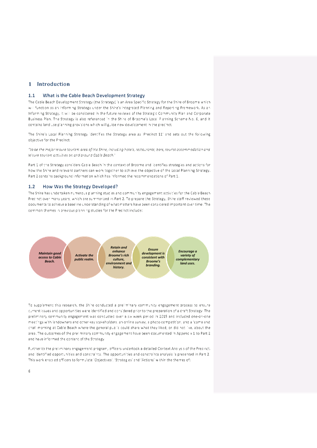

|
Item 9.2.1 - FINAL ADOPTION OF THE CABLE BEACH
DEVELOPMENT STRATEGY
|
|
Item 9.2.1 - FINAL ADOPTION OF THE CABLE BEACH
DEVELOPMENT STRATEGY
|
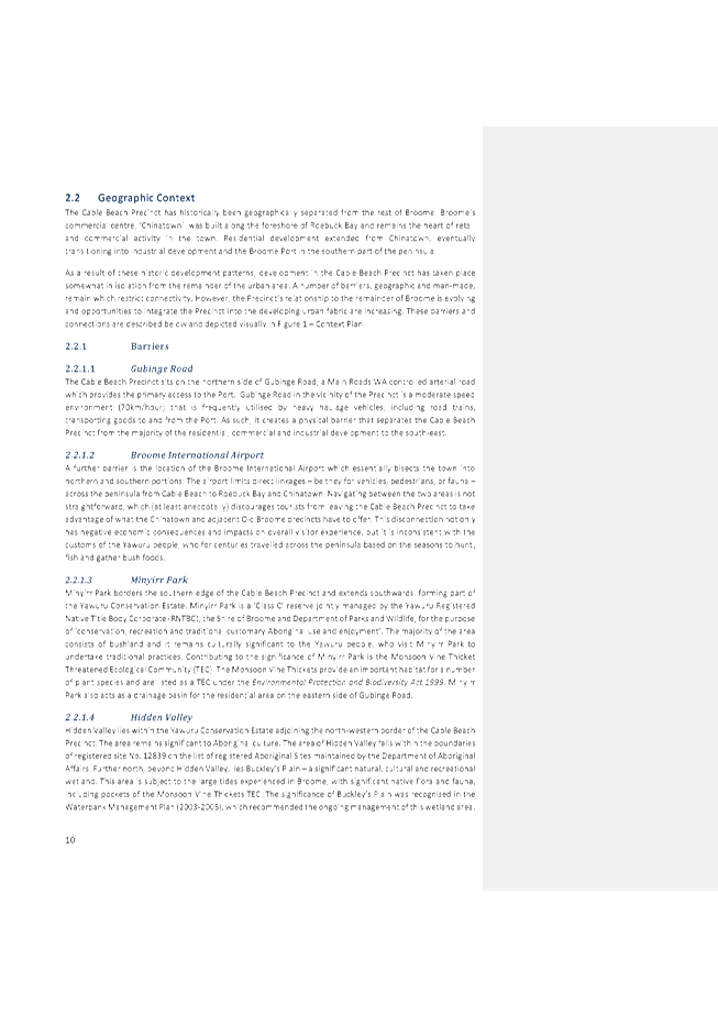
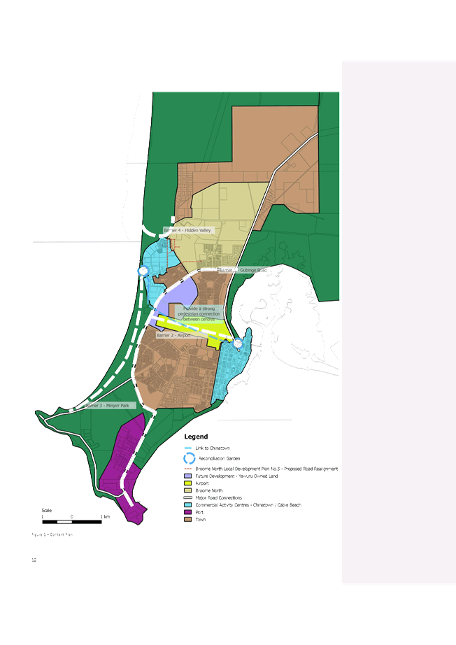
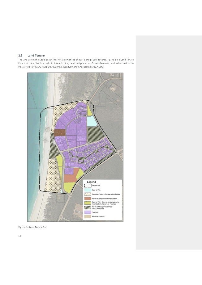
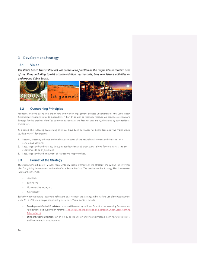
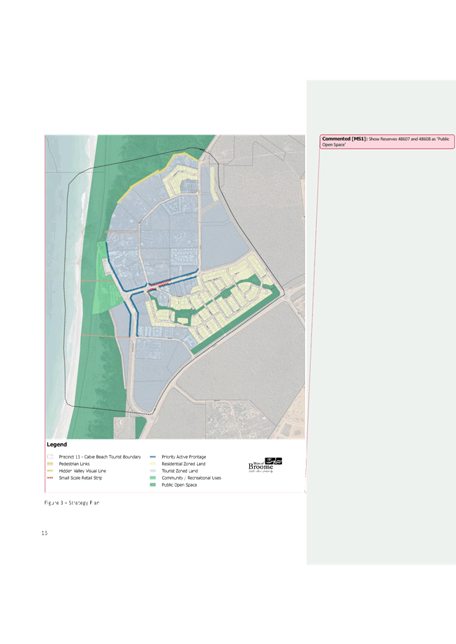
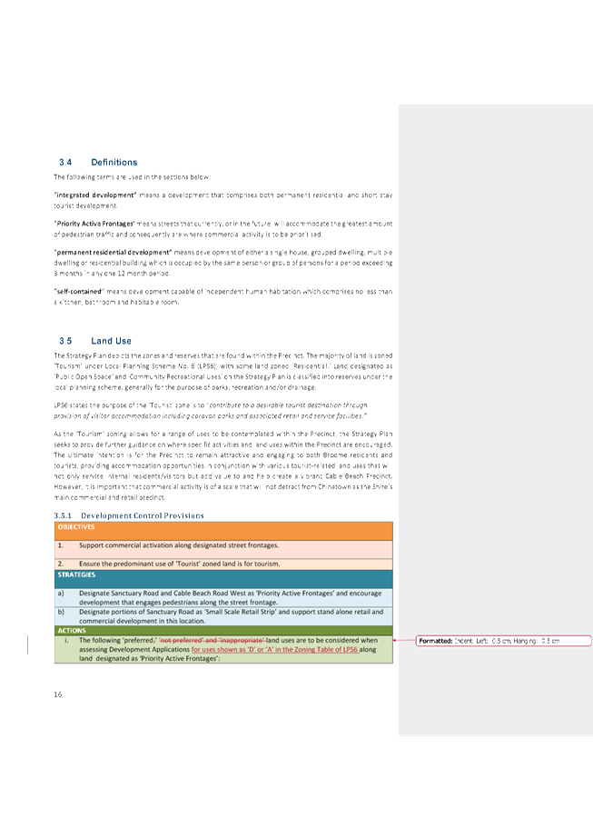
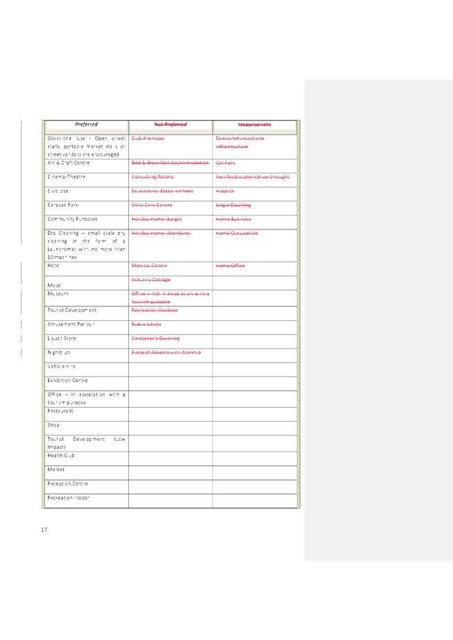
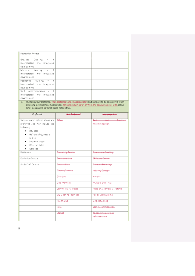
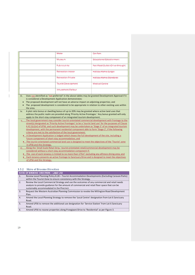
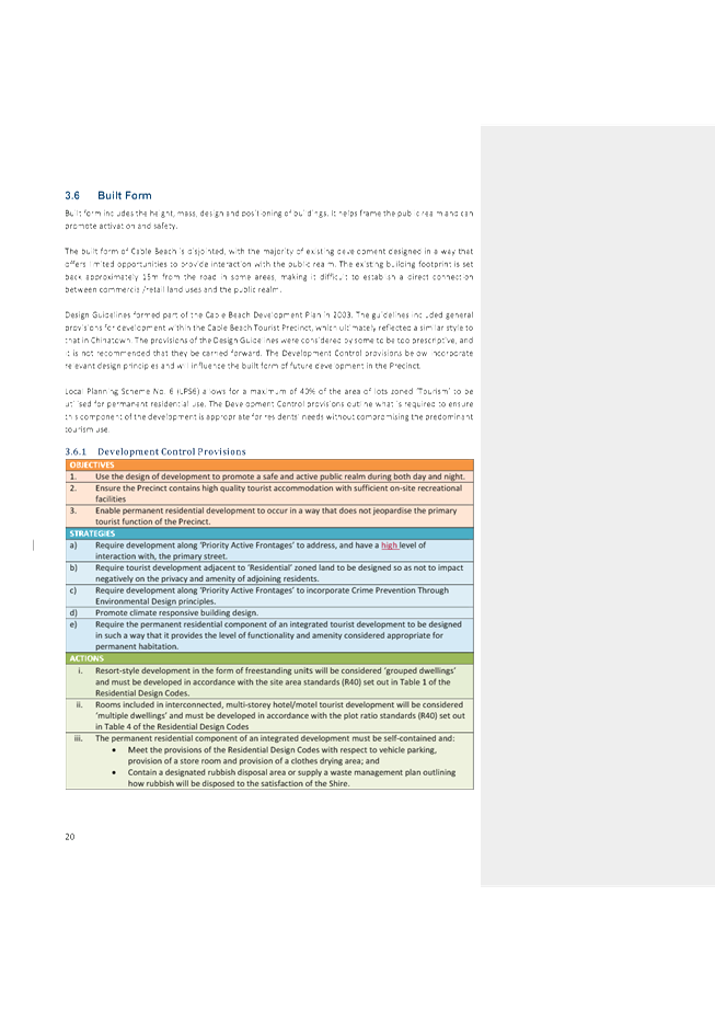
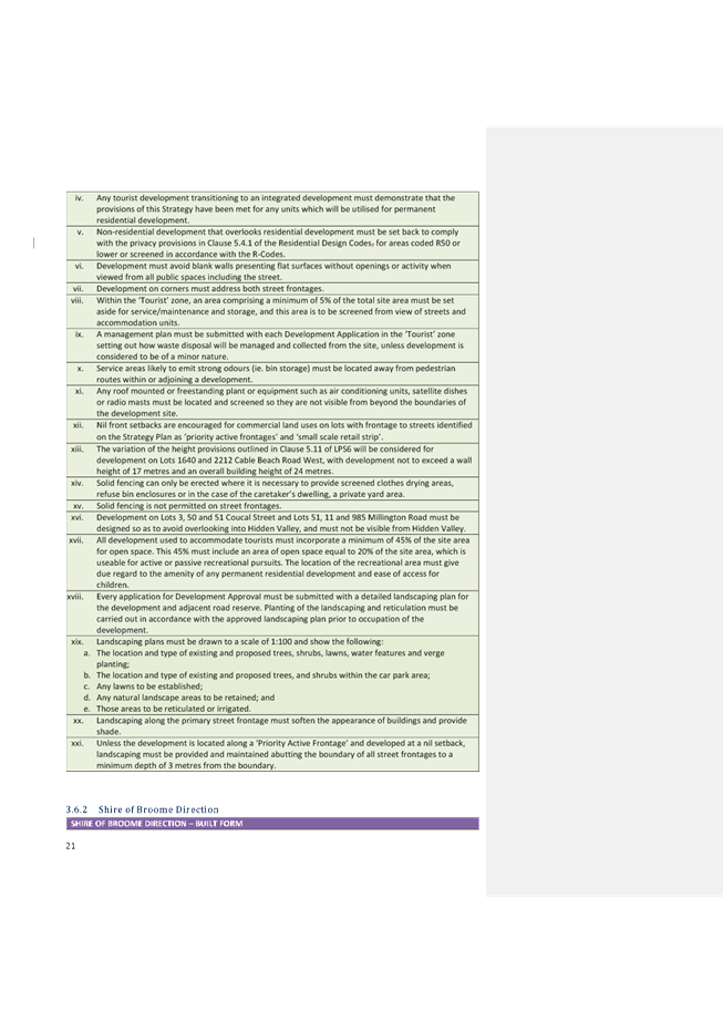


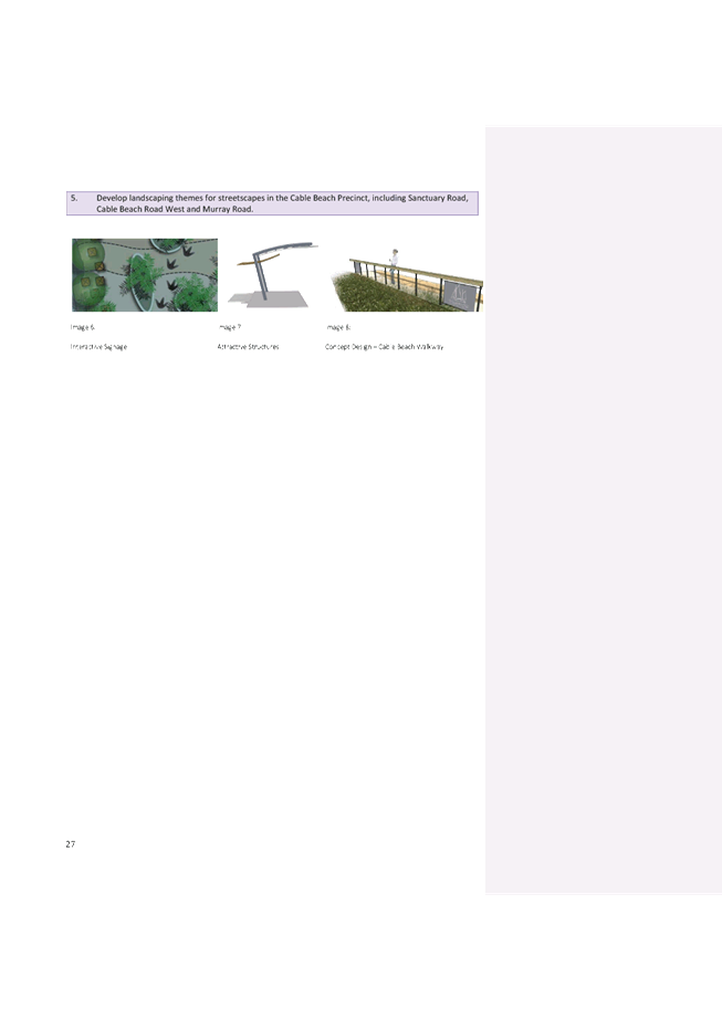

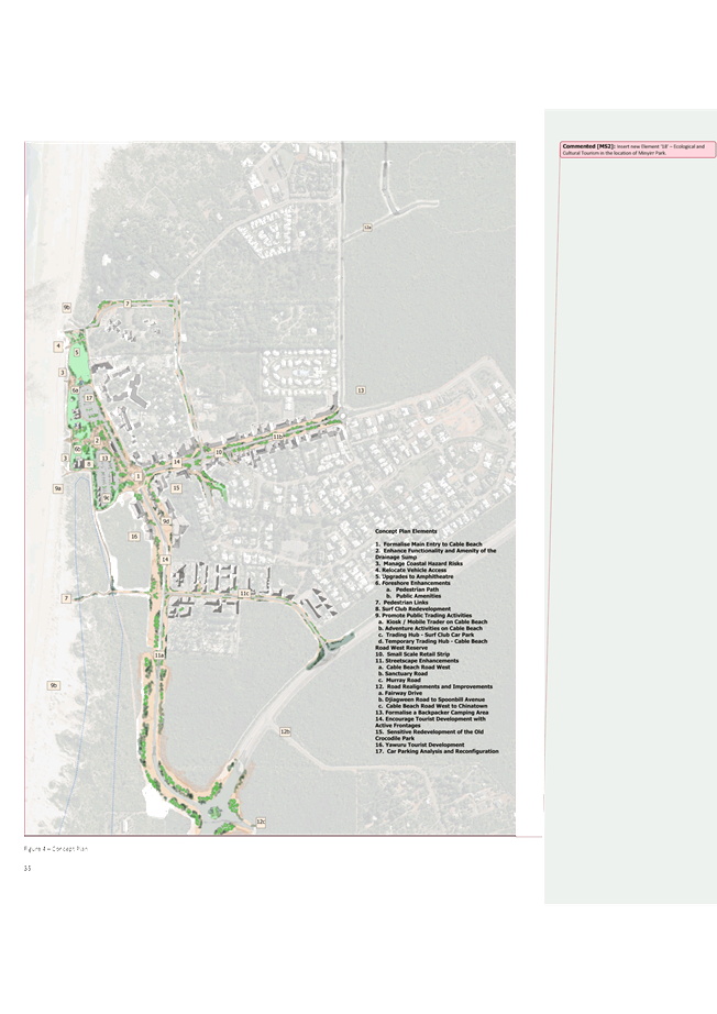


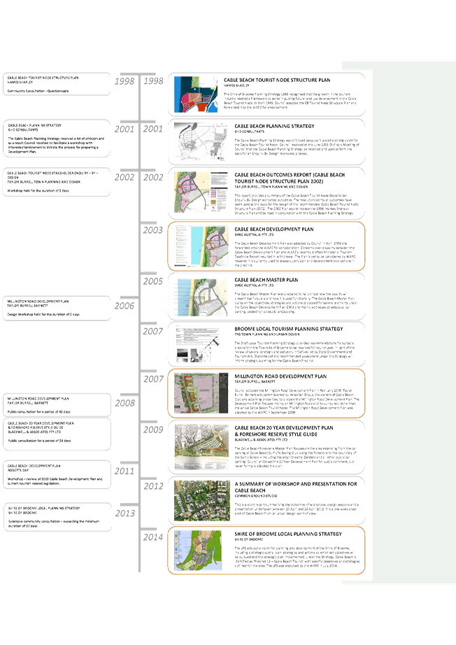


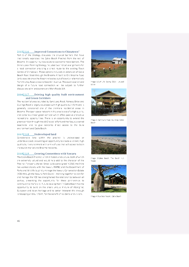
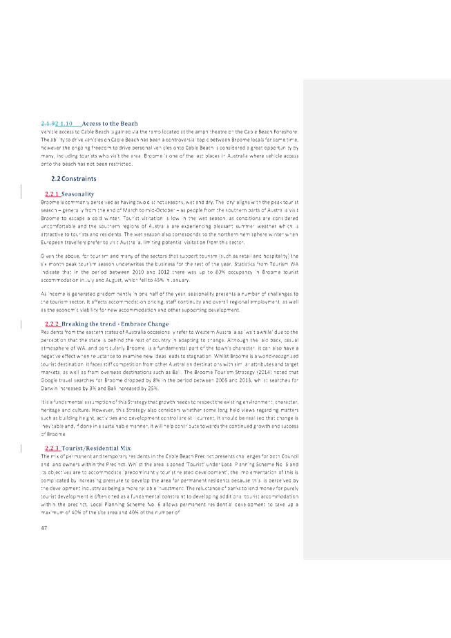
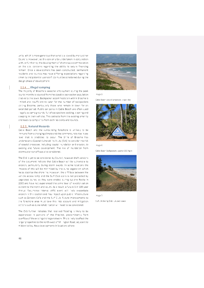

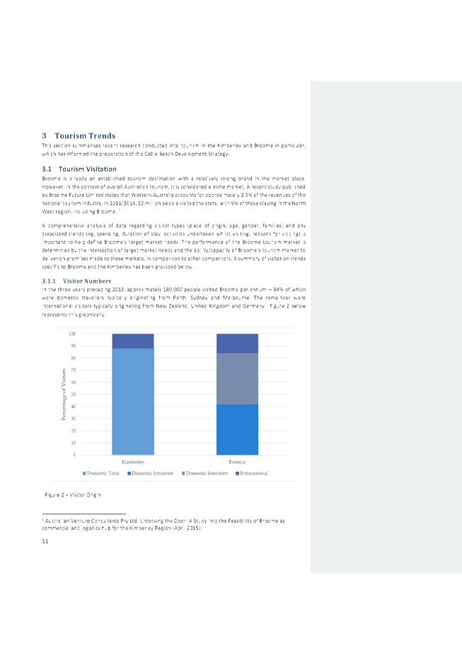
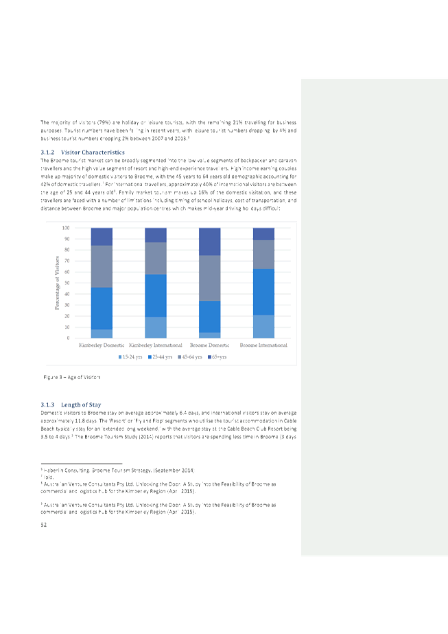
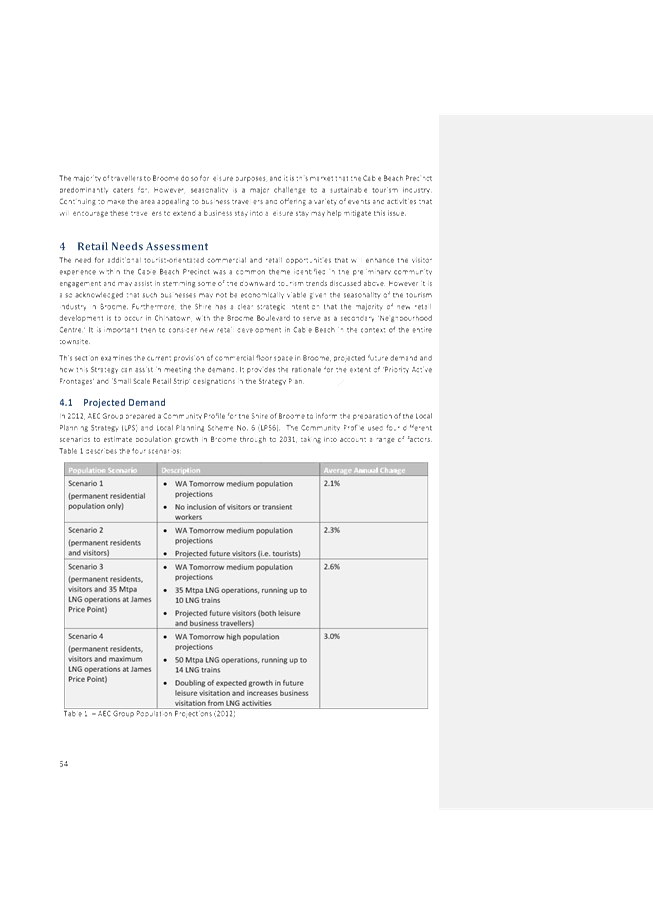


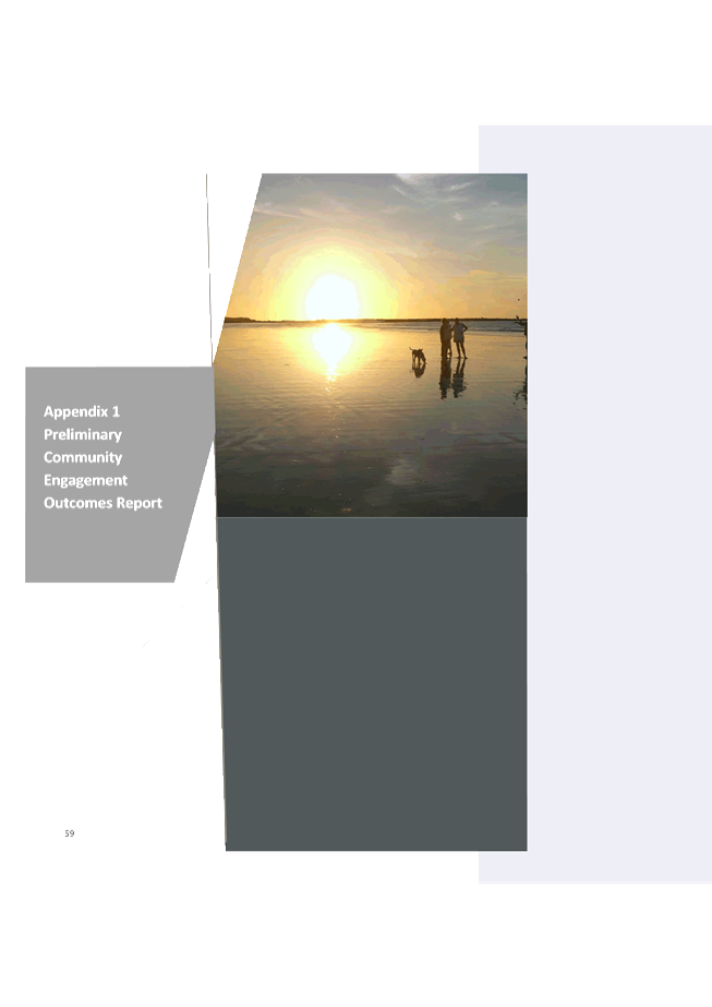


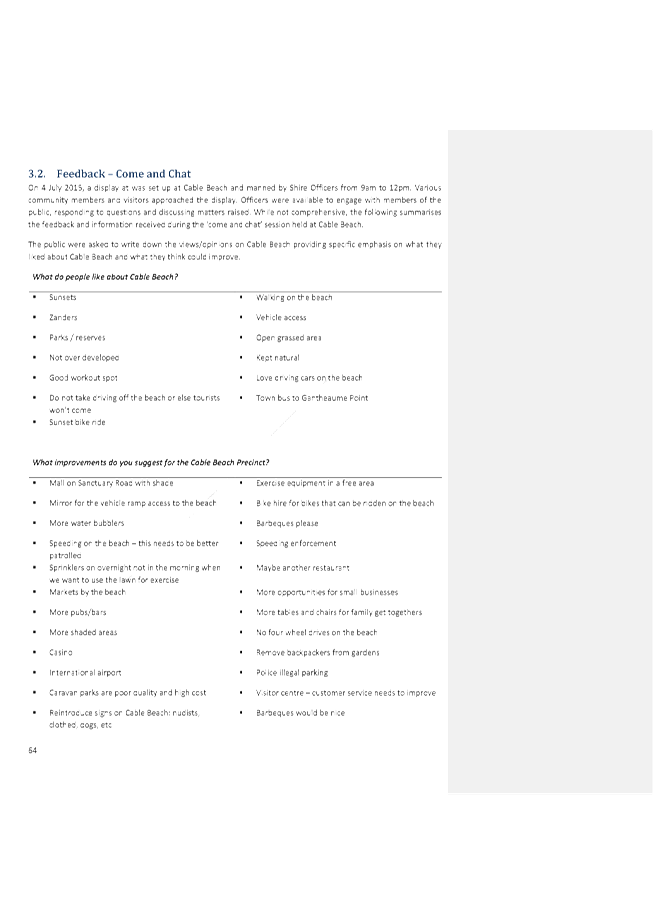

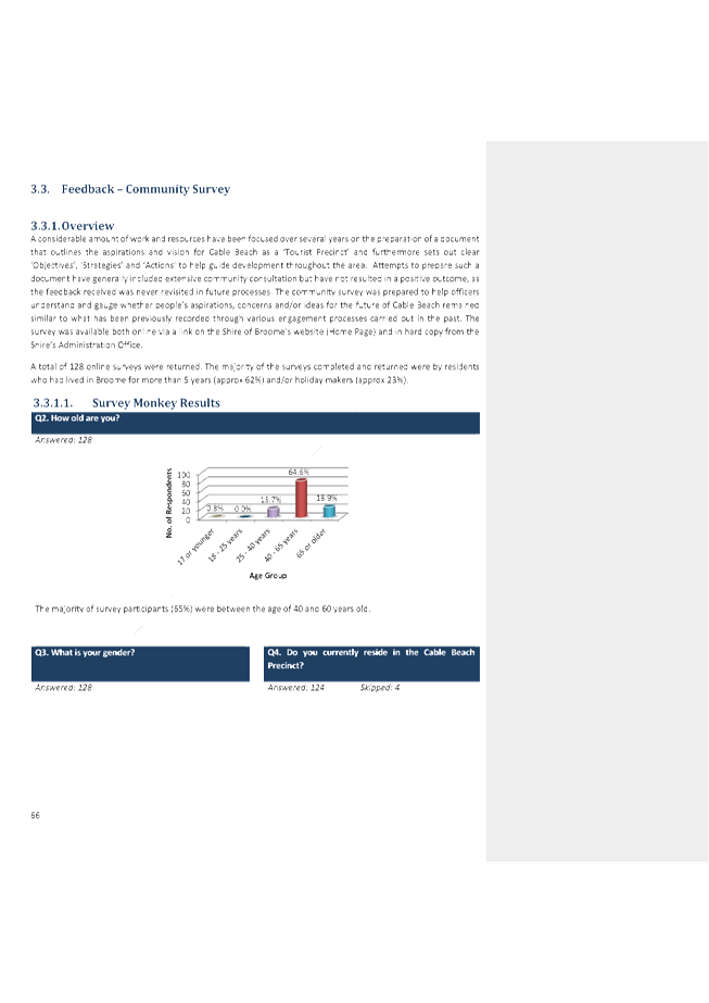
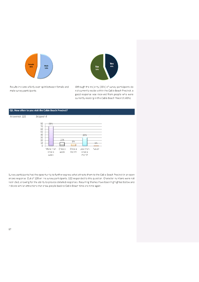
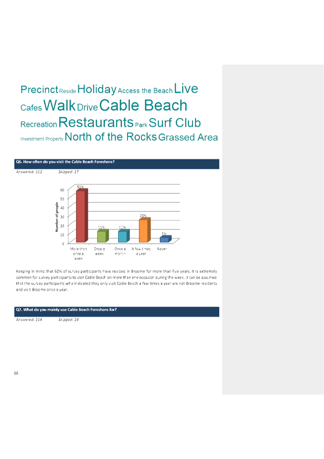


|
Item 9.2.1 - FINAL ADOPTION OF THE CABLE BEACH
DEVELOPMENT STRATEGY
|
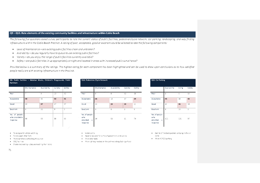

|
Item 9.2.1 - FINAL ADOPTION OF THE CABLE BEACH
DEVELOPMENT STRATEGY
|


|
Item 9.2.1 - FINAL ADOPTION OF THE CABLE BEACH
DEVELOPMENT STRATEGY
|
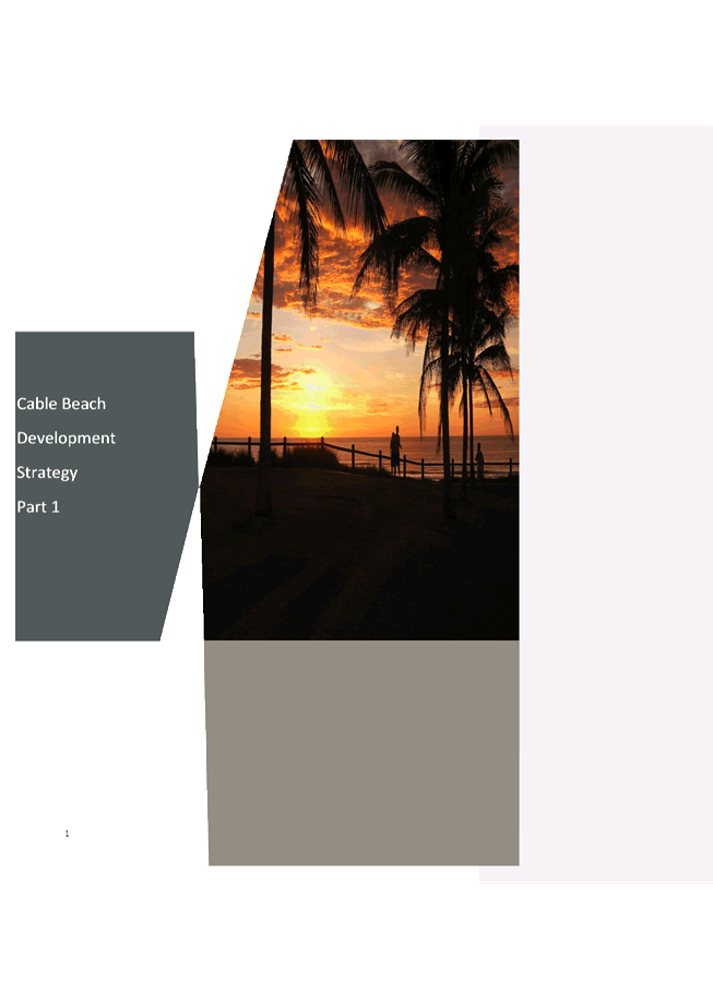


|
Item 9.2.1 - FINAL ADOPTION OF THE CABLE BEACH
DEVELOPMENT STRATEGY
|
|
Item 9.2.1 - FINAL ADOPTION OF THE CABLE BEACH DEVELOPMENT STRATEGY
|


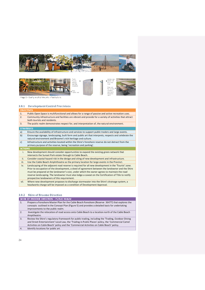
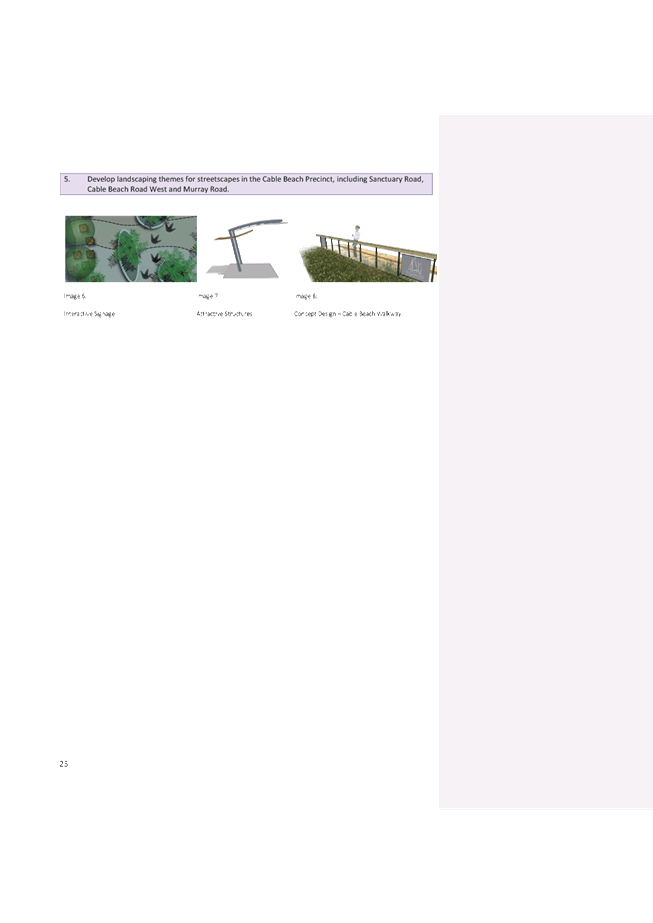


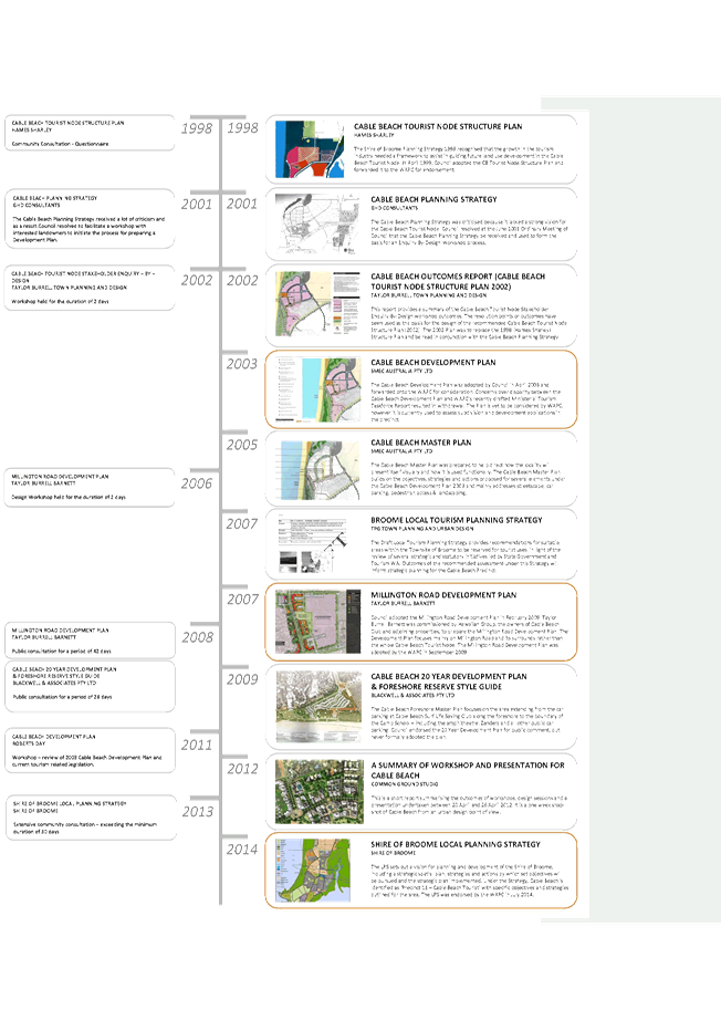


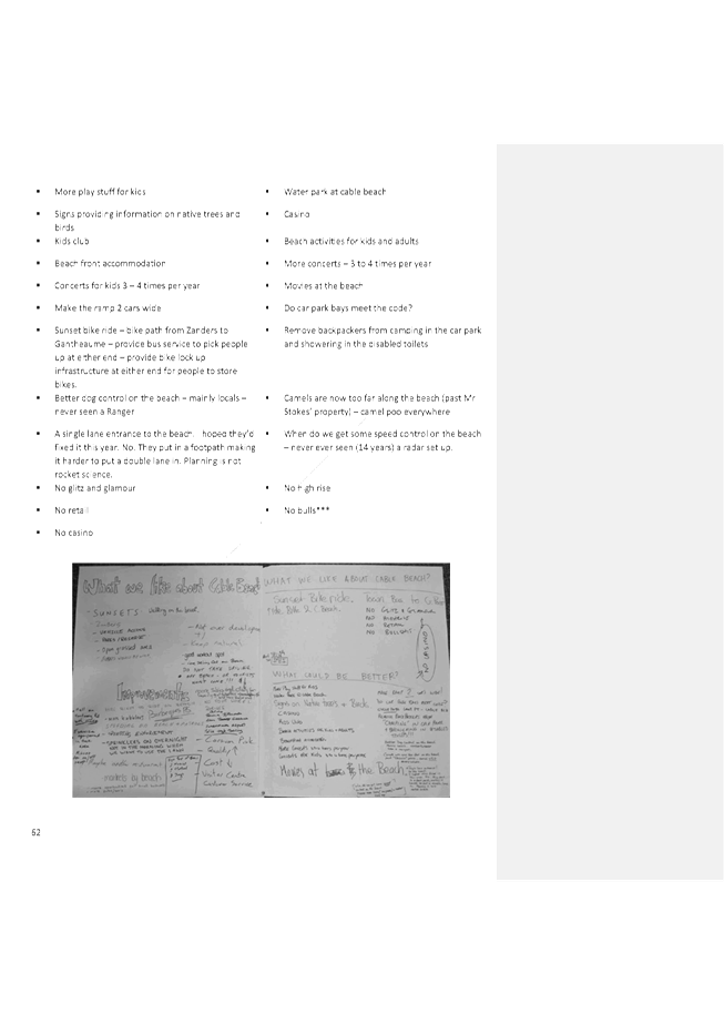
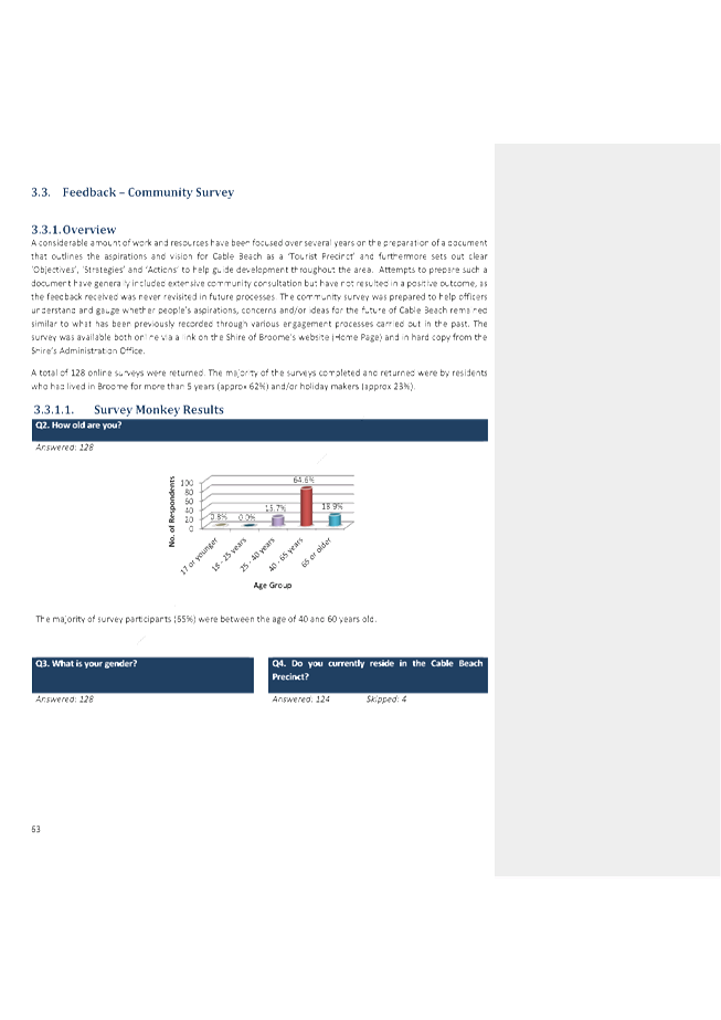


|
Item 9.2.1 - FINAL ADOPTION OF THE CABLE BEACH
DEVELOPMENT STRATEGY
|

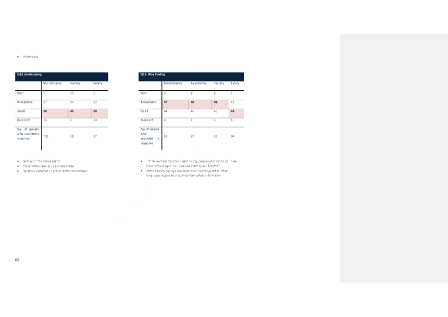
|
Item 9.2.1 - FINAL ADOPTION OF THE CABLE BEACH
DEVELOPMENT STRATEGY
|
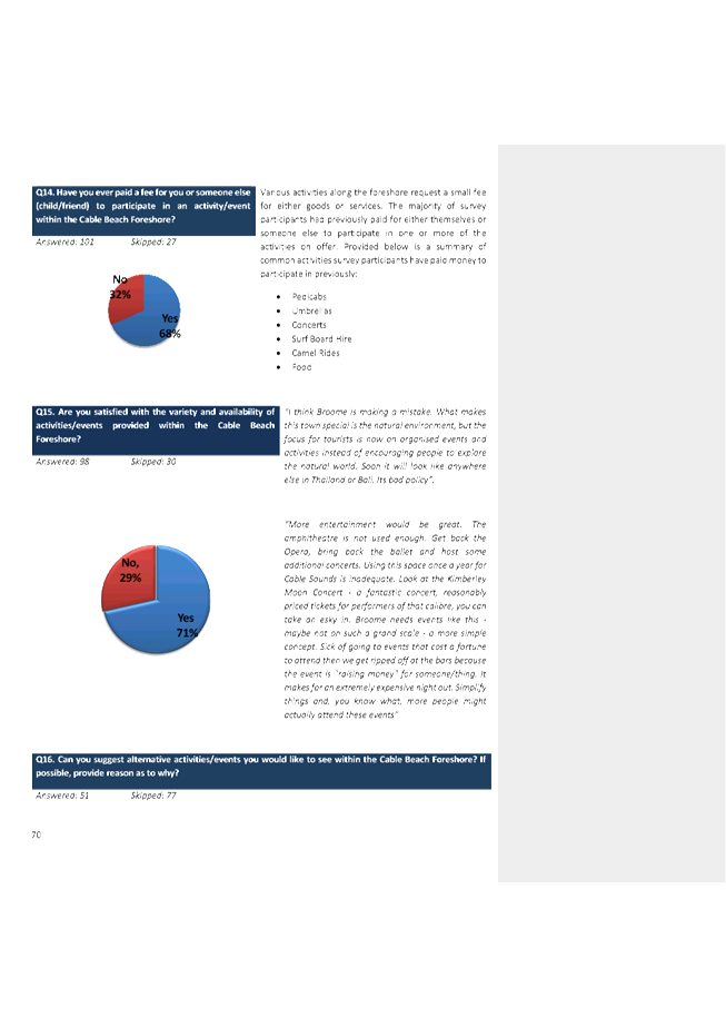


|
Item 9.2.1 - FINAL ADOPTION OF THE CABLE BEACH
DEVELOPMENT STRATEGY
|
|
9.2.2 LEASE DISPOSAL -
KIMBERLEY REGIONAL OFFICES, BUILDING 1, TENANCY 10
LOCATION/ADDRESS: Kimberley
Regional Offices, Building 1,Corner of Weld and Frederick Street, Broome
APPLICANT: Minister
for Works, Western Australian Police Force
FILE: LSS144,
RES8656
AUTHOR: Property
and Leasing Senior Officer
CONTRIBUTOR/S: Nil
RESPONSIBLE
OFFICER: Deputy
Chief Executive Officer/Director Community & Economic Development
DISCLOSURE
OF INTEREST: Nil
DATE OF REPORT: 11
May 2016
|
|
SUMMARY: The
Minister for Works – Western Australian Police Force (WAPOL) have
expressed interest in leasing tenancy 10 within the Kimberley Regional
Offices, building 1 (previously leased by Department of Corrective Services,
Youth Justice) for a term of 18 months commencing from 1 November 2016.
|
BACKGROUND
Previous
Considerations
OMC 19 February 2009 Item
9.4.10
OMC 24 July 2008 Item
9.4.2
Kimberley Regional Offices (KRO) is
on a Portion of Reserve 8656 (corner of Frederick and Weld Street, Broome) and
comprises two buildings (KRO1 and KRO2) which is vested in the Shire for the
purposes of “Office Accommodation.”
(Refer attachment 1)
The Department of Corrective Services
are the outgoing tenants of tenancy 10 and vacated on 30 June 2016. Corrective
Services have been occupying the premises since May 2009 and have relocated to
KRO 2, tenancy 4 where they have a lease through to November 2018.
There are three existing tenancies in
KRO building 1 as indicated below:
|
Tenancy
|
Occupant
|
Size (Sqm)
|
|
Tenancy 11
|
Dept of Housing
|
552.3
|
|
Tenancy 10
|
Vacant
|
438.4
|
|
Tenancy 9
|
K.I.F.S.A
|
157.7
|
On 11 May 2016, tenant representative
CB Richard Ellis (CBRE) contacted the Shire of Broome on behalf of the Minister
for Works to express interest in tenancy 10 at KRO 1. Negotiations resulted in
officers receiving a final proposal from CBRE on 3 June 2016 for
Council’s consideration/approval.
COMMENT
The terms proposed by CB Richard
Ellis on behalf of the Minister for Works are as follows:
(Refer attachment 2)
|
Lessee
|
Minister for Works
|
|
Premises
|
Tenancy 10 Kimberley Regional
Offices Complex
|
|
Net Lettable Area
|
438.36 sqm
|
|
Lease Term
|
18 months
|
|
Lease Break Option
|
The lessee will have the ability to
terminate the lease on any date no earlier than 31 October 2017 by serving
one month’s prior written notice to the lessor (“the break
notice”).
|
|
Lease Start Date
|
1 November 2016
|
|
Rent
|
As per independent valuation
$270.00 per sqm
|
|
Outgoings
|
Estimated at $195.00 per sqm
|
|
Lease Fees
|
At the expense of lessee
|
|
Lessor Works
|
Remove one non structural internal
wall as per lessee’s specifications, on or before 1 November 2016
|
|
Other terms and conditions
|
Consistent with the previous lease
between the Shire of Broome and Minister for Works as executed in September
2009.
|
Current
Market Conditions:
Over the last 12 months there has
been a significant decline in interest in office space from not-for-profit and
government agencies. It appears funding in these sectors has decreased
significantly, resulting in an increase in vacancy rates within the KRO complex
and more broadly across the community.
The following comments were also
reflected in Opteon Property Group’s recent valuation report dated 21
June 2016:
(Refer attachment 3)
“Commercial rents are
currently subdued with sitting tenants in most instances looking to
re-negotiate reductions in option periods. As for new leasing activity the
market has weakened and although no official vacancy rates are kept by leasing
agents we note discussions with one of the major commercial property agents have
revealed that there is limited enquiry/take up of commercial space within the
market place at present with landlords trying to hold onto their existing
tenants when lease terms conclude.
Recent rental evidence for
commercial tenancies within the area are generally between $275 to $425 per sqm
plus outgoings for commercial tenancies. Rents are dependent upon normal
property factors such as size, location, quality and functional utility of
their improvements. Smaller modern tenancies with high exposure to passing
traffic tend to attract rents towards the high end of the market rental range,
while commercial accommodation in secondary locations with low exposure and
older style improvements tend to attract rents towards the lower range.”
Valuation
On 21 June 2016 Opteon
Property Group carried out an independent rental valuation on tenancies 5, 6, 7
and 10 within KRO 1 and 2.
(Refer attachment 3)
The Minister for Works has made a net
rental offer in line with the valuation of $270 per square metre per annum.
Building Upgrades
The Minister of Works has requested
the removal of one non-structural wall, which is estimated to cost up to
$1000.00. There are sufficient funds budgeted in 2016/17 to undertake
these works.
It is recommended that Council enter
into a lease with the Minister for Works as per the outlined terms and
conditions.
CONSULTATION
Western Australian Police Force
CB Richard Ellis – Global
Corporate Services
Opteon Property Group
STATUTORY ENVIRONMENT
Local Government (Functions and General)
Regulations 1996
30. Dispositions
of property to which section 3.58 of Act does not apply
(1) A disposition that is described in this
regulation as an exempt disposition is excluded from the application of
section 3.58 of the Act.
(2) A disposition of land is an exempt
disposition if —
(a) the land is disposed of to an owner of adjoining land (in this
paragraph called “the transferee”) and —
(i) its market value is less than $5 000; and
(ii) the local government does not consider that ownership of the
land would be of significant benefit to anyone other than the transferee;
(b) the land is disposed of to a body, whether incorporated or
not —
(i) the objects of which are of a charitable, benevolent,
religious, cultural, educational, recreational, sporting or other like nature;
and
(ii) the members of which are not entitled or permitted to receive
any pecuniary profit from the body’s transactions;
(c) the land is disposed of to —
(i) the Crown in right of the State or the Commonwealth;
(ii) a department, agency, or instrumentality of the Crown in right
of the State or the Commonwealth; or
(iii) another local government or a regional local government;
(d) it is the leasing of land to an employee of the local government for
use as the employee’s residence;
(e) it is the leasing of land for a period of less than 2 years
during all or any of which time the lease does not give the lessee the
exclusive use of the land;
(f) it is the leasing
of land to a “medical practitioner” (as defined in section 3
of the Medical Act 1894) to be used for carrying on his or her medical
practice; or
(g) it is the leasing of
residential property to a person.
(2a) A disposition of
property is an exempt disposition if the property is disposed of within
6 months after it has been —
(a) put out to the highest
bidder at public auction, in accordance with section 3.58(2)(a) of the
Act, but either no bid is made or any bid made does not reach a reserve price
fixed by the local government;
(b) the subject of a public
tender process called by the local government, in accordance with
section 3.58(2)(b) of the Act, but either no tender is received or any
tender received is unacceptable; or
(c) the subject of Statewide
public notice under section 3.59(4), and if the business plan referred to
in that notice described the property concerned and gave details of the
proposed disposition including —
(i) the names of
all other parties concerned;
(ii) the consideration
to be received by the local government for the disposition; and
(iii) the market value of the
disposition as ascertained by a valuation carried out not more than
12 months before the proposed disposition.
(2b) Details (see
section 3.58(4) of the Act) of a disposition of property under
subregulation (2a) must be made available for public inspection for at
least 12 months from the initial auction or tender, as the case requires.
(3) A disposition of property other than land is
an exempt disposition if —
(a) its market value is less than $20 000; or
(b) it is disposed of as part of the consideration for other property
that the local government is acquiring for a consideration the total value of
which is not more, or worth more, than $50 000.
[Regulation 30
amended in Gazette 25 Feb 2000 p. 974‑5;
28 Apr 2000 p. 2041; 31 Mar 2005 p. 1055‑6.]
POLICY IMPLICATIONS
Nil
FINANCIAL IMPLICATIONS
|
Description
|
Income
|
Expenses
|
|
Net Annual Rent
|
$118,357.20 ex GST per annum
|
|
|
Outgoings
|
$85,488.00
|
$85,488.00
|
|
Lease Fees
|
$2500.00
|
$2500.00
|
|
Internal Wall Removal
|
Nil
|
$1,000.00
|
|
Net Gain over 12 months =
$117,357.20
|
There are sufficient funds within Acct 147272 KRO1 -
Building General Maintenance Expenses to fund the proposed internal wall
removal. Further, it is noted that total budgeted rental income at KRO
for 16/17 may require review and a future FACR amendment dependent on occupancy
rates within the KRO complex. The 16/17 budget was based on an estimated
conservative rental income with a built in factor for vacancies given the
current rental market conditions.
RISK
Should the tenancy not be approved,
the premises will remain vacant and the Shire will have to continue to absorb
the cost of outgoings totalling $85,488 plus forgone rental income.
STRATEGIC
IMPLICATIONS
Our People
Goal – Foster a community environment that is accessible, affordable,
inclusive, healthy and safe:
Affordable services and initiatives
to satisfy community need
Accessible and safe community spaces
Our Place
Goal – Help to protect the nature and built environment and cultural
heritage of Broome whilst recognising the unique sense of the place:
Core asset management to optimise
Shire’s infrastructure whilst minimising life cycle costs
Our
Prosperity Goal – Create the means to enable local jobs creation and
lifestyle affordability for the current and future population:
Affordable and equitable services and
infrastructure
Affordable land for residential,
industrial, commercial and community use
Our
Organisation Goal – Continually enhance the Shire’s organisational
capacity to service the needs of a growing community:
An organisational culture that
strives for service excellence
Sustainable and integrated strategic
and operational plans
Responsible resource allocation
VOTING REQUIREMENTS
Simple Majority
|
REPORT
RECOMMENDATION:
That Council:
(1) Accepts, in accordance with Local
Government (Functions and General) Regulations 1996, Section 30(2)(b)(i) the
request from the Minister for Works (Western Australian Police) to occupy
office space of approximately 438 square metres being tenancy 10 in the
Kimberley Regional Office building 1;
(2) Seeks Ministerial approval from the
Minister of Lands for the lease in accordance with Section 18 of the Land
Administration Act 1997;
(3) Authorises the Chief Executive Officer
to negotiate the final terms and conditions of the lease agreement as
follows:
a) Annual
rent at $270 per sqm plus GST - as per independent valuation;
b) 18
Month fixed term agreement with a 12 month break lease clause, exercised with
60 days written notice from the lessee;
c) Permitted
use is for ‘Office Accommodation’;
d) Lease
to be prepared by Council’s solicitor with the tenant to be responsible
for all associated
legal costs, including preparation and registration of lease documentation
e) The
landlord shall be provided with the expressed right to undertake preventative
maintenance at the cost of the tenant throughout the term. Current
preventative maintenance shall include but not limited to:
(i)
Pest inspection;
(ii)
Emergency service equipment inspection; and
(iii)
RCD and electrical inspection.
f) Utilities
service and consumption charges including telephone, electricity, gas and
water, covered by tenant through the variable outgoings;
g) Building
insurance to be effected by the landlord at the cost of the tenant, all other
insurances to be effected by the tenant, at the tenants cost.
(4) Authorises the Chief Executive Officer
and Shire President to engross the final lease documentation.
|
Attachments
|
1.
|
Tenancy 10 Site
Building Site Map
|
|
2.
|
Tenancy 10 Proposal
|
|
3.
|
KRO Valuation
(Confidential to Councillors and Directors Only)
This attachment is confidential in accordance with
Section 5.23(2) of the Local Government Act 1995 section 5.23(2)((e)(ii)) as
it contains “a matter that if disclosed, would reveal information that
has a commercial value to a person, where the information is held by, or is
about, a person other than the local government”.
|
|
Item 9.2.2 - LEASE DISPOSAL - KIMBERLEY REGIONAL OFFICES,
BUILDING 1, TENANCY 10
|
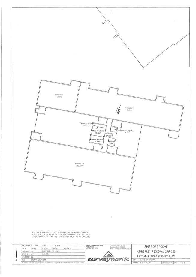
|
Item 9.2.2 - LEASE DISPOSAL - KIMBERLEY REGIONAL OFFICES, BUILDING 1, TENANCY
10
|

|
9.2.3 DESIGNATED COUNCIL
PARKING AREAS LAYOUT AND TIME RESTRICTIONS PLAN - CHINATOWN
LOCATION/ADDRESS: Chinatown
APPLICANT: Shire
of Broome
FILE: PLA57
AUTHOR: Statutory
Planning Coordinator
CONTRIBUTOR/S: Ranger
Coordinator
Development and Subdivision Engineer
Manager Building Services
Acting Manager Community Development
RESPONSIBLE
OFFICER: Director
Development Services
DISCLOSURE
OF INTEREST: Nil
DATE OF REPORT: 28
June 2016
|
|
SUMMARY: Under
the Shire of Broome Parking and Parking Facilities Local Law 2012, Council
may by resolution determine parking stalls and parking facilities. Council
adopted a Parking Plan for Chinatown in 2005. Given the number of parking
improvements that have occurred within the Chinatown area since 2005, an
updated Parking Plan is required and is presented to Council for adoption.
|
BACKGROUND
Previous
Considerations
OMC 3 November 2005 Item
9.5.2
Under the provisions of the Shire of
Broome Parking and Parking Facilities Local Law 2012 (Local Law),
Council may by resolution determine parking stalls and parking facilities and
as a part of this resolution can determine:
· The permitted time
and conditions of parking in parking stalls and parking facilities;
· Permitted classes
of vehicles which may park in the parking stalls and parking facilities; and
· Permitted classes
of persons who may park in specified parking stalls and parking facilities.
Such a resolution then enables an
‘Authorised Officer’ (the Rangers) to enforce the provisions of the
Local Law.
The last resolution of Council was
made at the Ordinary Meeting of Council (OMC) on 3 November 2005. At
this time, Council resolved to adopt Drawing No C05-001 dated 1 June 2005 (Attachment
No 1) as the overall parking plan for all public roads and reserves in the
Chinatown area. Since this time, a number of changes have occurred and has
resulted in the need for Council to adopt a new plan.
COMMENT
Since the adoption of the Designated
Council Parking Areas Layout and Time Restrictions Plan (Parking Plan)
at the November 2005 OMC a number of parking improvements have been undertaken
which have given rise to the need for Council to make a new resolution under
the Local Law. The following notable changes have occurred:
· Frederick Street
has been extended to connect to Dampier Terrace;
· The parking bays
on the eastern side of the Dampier Terrace road reserve (next to Streeters
Jetty) have been installed;
· The parking bays
around the Broome Visitors Centre have been constructed; and
· The taxi rank that
previously existed in Carnarvon Street in front of Paspaley Plaza has been
relocated to Short Street.
To reflect the above changes, an
updated Parking Plan has been prepared. Further, it is proposed that some
further changes are made to the existing parking bays. In the main, the changes
proposed relate to improvements to disabled parking bays following an audit
undertaken by the Infrastructure Directorate. The updates and changes have been
prepared in collaboration with officers from the Shire’s Infrastructure,
Development and Community Development Directorates.
The following amendments are proposed
to the Parking Plan adopted in November 2005. These changes are cross
referenced with the numbering in the table below on the plan in Attachment
No 2.
|
No.
|
Description of Modification
|
Reason
|
|
1
|
Inclusion of an additional 8
parking bays in front of 10 Frederick Street as ‘Public Parks on Road
Reserve (Maintained by Owners)’.
|
Reflect parking that has been
installed by a developer as a part of the adjacent development.
|
|
2
|
Inclusion of 10 parallel bays in
Frederick Street adjacent to the Police Station shown as unrestricted
parking.
|
Reflect parking improvements that
have been installed.
|
|
3
|
Inclusion of 6 parallel bays and 4
angled bays on Frederick Street as unrestricted parking.
|
Reflect parking installed as a part
of the Frederick Street extension.
|
|
4
|
Inclusion of 4 additional angled
parking bays on Dampier Terrace adjacent to the Frederick Street upgrade.
|
Reflect parking installed as a part
of the Frederick Street extension.
|
|
5
|
Bay previously shown as motorbike
has been amended to be an unrestricted car park.
|
Reflect the on-ground parking
arrangement.
|
|
6
|
Removal of one of the bays shown as
‘Public Parks on Road Reserve’ in front of 44 Dampier Terrace.
|
The bay was removed as a part of
the works undertaken in the Frederick Street extension.
|
|
7
|
Alter the configuration of the
disabled parking on Napier Terrace to include two disabled parking spaces and
remove one motorbike bay.
|
This is proposed to ensure that the
disabled bays meet with the updated Australian Standard.
|
|
8
|
On the opposite side of Napier
Terrace, remove one 2 hour parking bay and replace with two motorbike bays.
|
This is proposed given that the
motorbike bay on the southern side of Napier Terrace is proposed to be
removed.
|
|
9
|
Amend the parallel parking
configuration on Carnarvon Street to show a run of five unrestricted bays
(instead of six) and three motorbike bays (instead of 1).
|
To reflect the on-ground parking
configuration.
|
|
10
|
Remove the three taxi bays in front
of 23 Carnarvon Street and replace with 2 hour parking bays.
|
As taxi parking bays are available
on the western side of Carnarvon Street, this is deemed to be an unnecessary
duplication.
|
|
11
|
Inclusion of an additional
motorbike bay on Short Street in front of 1 Short Street
|
To reflect the on-ground parking configuration.
|
|
12
|
Addition of eight parking bays in
front of the Roebuck Bay Hotel as ‘Taxi/Car’ This provides for
these bays to be used as taxi pick up points from 6pm to 6am and then 2 hour
timed parking outside those hours.
|
To reflect the on-ground parking
configuration and signage.
|
|
13
|
Two parking bays in front of 31
Dampier Terrace have been removed.
|
To reflect the on-ground parking
configuration a pedestrian island has been installed.
|
|
14
|
Inclusion of an additional disabled
bay in front of 25 Dampier Terrace and an additional motorbike bay.
|
This is proposed to ensure that the
disabled bays are compliant with the updated Australian Standard.
|
|
15
|
Removal of one disabled bay and two
dual taxi/car parking bays in front of 18 Dampier Terrace and replaced with
six motorbike bays.
|
This is proposed as the disabled
bay will be relocated and to provide additional motorbike parking in this
location.
|
|
16
|
Inclusion of twenty-nine
unrestricted parking bays, three motorbike bays and two disabled bays on the
eastern side of Dampier Terrace near Streeters Jetty.
|
To reflect the on-ground parking
configuration.
|
|
17
|
Removal of two motorbike bays.
|
To reflect the on-ground parking
configuration.
|
|
18
|
Relocation of the disabled bay in
front of Australia Post so it is at the start of the run of parking bays, not
in the middle.
|
This is proposed to improve the
accessibility and functionality of this disabled bay. In the current
configuration the disabled bay is bookended by car bays. This amendment will
provide more space at the rear of the disabled bay.
|
|
19
|
Removal of three 2 hour parking
bays and replacement with nine motorbike parking bays.
|
This is proposed as currently there
is an under provision of motorbike parking bays along this portion of
Chinatown.
|
|
20
|
Inclusion of three 2 hour parking
bays in front of the Paspaley Shopping Centre entrance on Carnarvon Street,
previously were taxi bays.
|
To reflect the recent works
undertaken which relocated these taxi bays to the other entrance to the
Paspaley Shopping Centre on Short Street.
|
|
21
|
Relocation of the disabled bay on
the southern side of Short Street in front of 6 Short Street so it is
adjacent to the disabled bay on the other side of Short Street.
|
This is proposed to ensure that the
disabled bays are compliant with the updated Australian Standard.
|
|
22
|
Removal of angled parking bays on
Short Street and reinstated with two parallel taxi parking bays.
|
To reflect the on-ground parking
configuration.
|
|
23
|
Removal of four angled parking bays
and replacement with one bus stop.
|
To reflect the on-ground parking
configuration.
|
|
24
|
Amendments to the disabled parking
bays configuration so both parking bays are adjacent to each other and with a
common shared area.
|
This is proposed to ensure that the
disabled bays are compliant with the updated Australian Standard.
|
|
25
|
The bays in proximity to the Broome
Visitors Centre in the 2005 Parking Plan were shown as proposed. The updated
plan shows these bays as constructed. The allocation of the bays reflects the
current on the ground parking. The only proposed changes relate to the
configuration of the disabled bays.
|
To reflect the on-ground parking
configuration. The changes to the disabled bays is proposed so they are
compliant with the Australian Standards.
|
|
26
|
Inclusion of eight parallel
unrestricted parking bays on Hamersley Street adjacent to Male Oval.
|
To reflect the on-ground parking
configuration.
|
|
27
|
Inclusion of a nominal amount of
bays which could potentially be constructed on Reserve 34305.
|
This Reserve is vested with the
Shire of Broome for the purposes of drainage and parking. This site has the
potential to be improved in the future for additional parking.
|
In summary, the amendments result in
the following allocation of bays within the Chinatown:
· 134 - Public
parking bays on road reserves (maintained by owners);
· 312 - Unrestricted
parking bays;
· 26 - 15 minute
parking bays;
· 271 - 2 hour
parking bays;
· 4 - Taxi bays;
· 11 - Combined taxi
and car parking bays (Taxi between the hours of 6pm and 6am and 2 hour parking
otherwise);
· 5 - Bus stops;
· 5 - Loading bays;
· 21 - Disabled
bays;
· 13 - Coach parking
bays; and
· 53 - Motorbike
bays.
The plan also shows the more
substantial car parking areas that exists on private property. These bays are
not maintained or regulated by the Shire, however have been included on the
plan to give a true representation of the amount of parking bays constructed
within Chinatown. Once this plan has been adopted by Council, it is proposed
that copies be placed on the Shire’s website to increase the public
awareness about the amount and location of bays in Chinatown. There are a total
of 510 parking bays that are private car parks.
Further the plan shows possible
future parking areas, of which there is a capacity for an additional 170
parking bays. These bays currently do not form part of the Shire’s
Forward Capital Works program. However, this does show where funds
received through cash-in-lieu payments from developments proposed within
Chinatown could potentially be expended.
The Parking Plan has been discussed
at the Chinatown Working Group Meeting where the following amendments were
suggested and have been incorporated:
· The 2005 parking
plan showed a crossover existing on Carnarvon Street in front of the ANZ Bank.
This is not a crossover and the 2016 Parking Plan has been updated to show this
as a 2 hour timed parking bay.
· The disabled bay
on Short Street in front of Paspaley Pearls was shown as a 2 hour parking bay
on the version of the Parking Plan tabled at the meeting. Feedback was received
that this bay is well utilised and should be kept as a disabled bay.
· It was requested
that a nominal amount of parking bays be shown on the Shire Reserve on the
western side of Hamersley Street (in close proximity to Magabala Books). This
has been updated on the 2016 Parking Plan.
The Parking Plan was also discussed
at an Access and Inclusion Workshop attended by members of the Access and
Inclusion Committee. The amendments proposed were supported and it was recommended
that a disabled bay be included at the southern extent of the Dampier Terrace,
close to the area of the Frederick Street extension. This request was made for
the following reasons:
· This area is
currently not serviced with a disabled bay and considering the potential
improvements that may be undertaken (such as the look-out) a disabled bay would
allow for universal access.
· There is a medial
practice within proximity to this area.
· This area is at a
higher elevation that the majority of Chinatown making it difficult for
disabled access to be achieved.
This amendment is shown on the
updated 2016 Parking Plan and is supported by officers.
In summary it is considered that the
updated Parking Plan is appropriate and reflective of the parking conditions in
Chinatown. The updated Parking Plan reflects the on-the-ground changes that
have occurred since 2005 and the additional changes proposed represent an
improved layout of parking bays in Chinatown.
CONSULTATION
The updated Parking Plan was tabled
for discussion and input at a Chinatown Working Group Meeting and also a
workshop held with members of the Access and Inclusion Committee Meeting. The
Parking Plan has been updated following discussions held.
STATUTORY ENVIRONMENT
Local Government Act 1995
Shire of Broome Parking and Parking
Facilities Local Law 2012
Part 2 – Parking Stalls and Parking Facilities
2.1 Determination of parking stalls and parking facilities
(1) The
Council may by resolution constitute, determine and vary –
(a) parking
stalls;
(b) parking
facilities;
(c) permitted
time and conditions of parking in parking stalls and parking facilities which
may vary with the locality;
(d) permitted
classes of vehicles which may park in parking stalls and parking facilities;
(e) permitted
classes of persons who may park in specified parking stalls or parking
facilities; and
(f) the
manner of parking in parking stalls and parking facilities.
(2) Where
the Council makes a resolution under subclause (1) it shall erect signs to give
effect to the determination.
POLICY IMPLICATIONS
Nil.
FINANCIAL IMPLICATIONS
The line marking and signage changes
required to action the changes through the adoption of this updated Parking
Plan will be met through the current maintenance budget.
RISK
If the new Parking Plan is not
adopted, there is a risk that parking infringement notices issued by Shire
Rangers in Chinatown may be subject to legal challenge.
STRATEGIC
IMPLICATIONS
Our People
Goal – Foster a community environment that is accessible, affordable,
inclusive, healthy and safe:
Effective communication
Accessible and safe community spaces
Our Place
Goal – Help to protect the nature and built environment and cultural
heritage of Broome whilst recognising the unique sense of the place:
Retention and expansion of
Broome’s iconic tourism assets and reputation
Our
Organisation Goal – Continually enhance the Shire’s organisational
capacity to service the needs of a growing community:
Improved systems, processes and
compliance
VOTING REQUIREMENTS
Simple Majority
|
REPORT
RECOMMENDATION:
That Council:
1. Pursuant
to Clause 2.1(1) of the Shire of Broome’s Parking and Parking
Facilities Local Law 2012 adopts the Designated Council Parking Areas Layout
and Time Restrictions Plan, Revision G dated 05 July 2016.
2. Pursuant
to Clause 2.1(2) of the Shire of Broome’s Parking and Parking
Facilities Local Law 2012 requests the Chief Executive Officer to erect signs
and line markings to give effect to the Designated Council Parking Areas
Layout and Time Restrictions Plan.
|
Attachments
|
1.
|
Attachment No 1 - 2005
Car Parking Plan
|
|
2.
|
Attachment No 2 - 2016
Parking Plan Showing Amendments
|
|
3.
|
Attachment No 3 - 2016
Parking Plan
|
|
Item 9.2.3 - DESIGNATED COUNCIL PARKING AREAS LAYOUT AND
TIME RESTRICTIONS PLAN - CHINATOWN
|
|
Item 9.2.3 - DESIGNATED COUNCIL PARKING AREAS LAYOUT AND TIME RESTRICTIONS PLAN
- CHINATOWN
|
|
Item 9.2.3 - DESIGNATED COUNCIL PARKING AREAS LAYOUT AND TIME RESTRICTIONS PLAN
- CHINATOWN
|
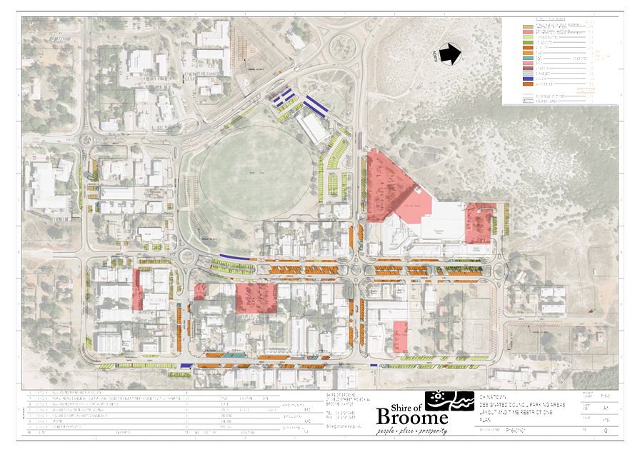
|
9.2.4 APPLICATION FOR
RETROSPECTIVE DEVELOPMENT APPROVAL - PROPOSED SHOP
LOCATION/ADDRESS: Lot
481 (No.9) Short Street
APPLICANT: West
Coast Plan on behalf of Hutch Investments Pty Ltd
FILE: SHO-1/9
AUTHOR: Planning
Officer
CONTRIBUTOR/S: Nil
RESPONSIBLE
OFFICER: Director
Development Services
DISCLOSURE
OF INTEREST: Nil.
DATE OF REPORT: 5
July 2016
|
|
SUMMARY: An
application for retrospective Development Approval has been received for a
variation to the parking requirements of Local Planning Policy 8.16
– Provision of Parking (LPP 8.16) in association with a
‘Shop’ use.
While submitted plans detail the availability of eleven
(11) car parking bays on-site, Schedule 16 – Car, Motorcycle and
Bicycle Ratios in Local Planning Scheme No. 6 requires that a minimum of
fifteen car parking bays are required to service both existing and proposed
development on-site. The applicant seeks approval for a shortfall of four
parking bays. In accordance with LPP 8.16, any application to vary
parking requirements must be determined by Council. The application is
therefore presented to Council for its consideration.
This report recommends that the application be approved,
subject to a condition requiring the payment of a cash-in-lieu contribution
for four car parking bays in accordance with the provisions of Local
Planning Policy 8.9 – Cash in Lieu of Car Parking Chinatown.
|
BACKGROUND
Previous
Considerations
OMC 1 August 2007 Item
9.3.8
OMC 18 April 2000 Item
4.6
Site and Surrounds
Located in Chinatown, the ‘Town
Centre’ zoned site is bounded by Short Street to the north and Sam Su
Lane to the east (Refer Attachment 1 - Location Plan). Adjoining
land-use comprises the ‘Broome Visitor Centre’ and parking area to
the west, while ‘Shop’ and ‘Cinema’ land-uses are
located to the north across Short Street and to the east across Sam Su Lane.
Male Oval abuts the rear boundary of the lot to the south. The 809sqm lot
enjoys vehicular access via hard-sealed cross-overs onto both Short Street and
Sam Su Lane. Existing development on-site comprises:
- Five
tenancy ‘Office’ land-use on ground-floor fronting Short Street;
- A
two-bedroom multiple dwelling positioned above the office development;
- 42sqm
two-car garage building;
- Hard-sealed
car parking area comprising eleven (11) car parking bays.
Background
On 18 April 2000 Council resolved to
grant approval for a two-storey ‘Retail Development with Residential
Component’. In intervening years, the commercial land-use on-site has
changed from retail to ‘Office’, which is a permitted use within
the Town Centre zone. The development as approved comprised five ground-floor
retail tenancies, an upstairs residential dwelling and fourteen on-site car
parking bays. As part of a subsequent application for a boundary fence, Council
on 10 July 2007 granted approval for a two-car garage to be constructed to the
rear of the lot, with approved plans showing the availability of a total of
thirteen parking spaces on-site including the garage.
The Proposal
The application seeks retrospective
approval for a variation to parking requirements in association with the use of
the existing garage building on-site for a dive ‘Shop’. Of the
thirteen bays approved for the land-uses on the lot, the ‘Shop’
will remove a further two car parking bays, leaving eleven bays available for
the entirety of use on-site (Refer Attachment 2 – Plans).
COMMENT
Land Use – Local Planning
Strategy & Chinatown Development Strategy (CDS)
Being within the ‘Town Centre’
zone, a ‘Shop’ is a permitted land-use on the lot in accordance
with the provisions of LPS 6. The proposal is consistent with the purpose of
the ‘Town Centre’ zone in that it will be complementary to the
functioning of Chinatown as the principal commercial centre for Broome, as set
out under the Local Planning Strategy and the Chinatown Development Strategy
(CDS).
Development
With the exception of car parking
provision, the development satisfies all site and development requirements of
Local Planning Scheme No. 6 (LPS 6), the CDS and the Chinatown Urban Design
Guidelines (refer Attachment 3 – Planning Assessment Summary).
Submitted plans of elevation detail
the installation of signage on the façade of the garage. While the
signage complies with the Shire’s Signs Local Planning Policy, referral
of signage to the State Heritage Office was required on the basis that the site
is located within the State Heritage Listed Chinatown Conservation Area. As set
out in the Consultation section of this report, no objections or
recommendations to the signage as proposed were received from the State
Heritage Office.
The development proposes 42sqm of
shop floor-space, which as outlined in Schedule 16 of LPS 6, requires the
provision of parking at a rate of 1 bay per 25sqm gross-floor area. With all
available land on-site already accounted for via existing development and
car-parking, there is no space available on-site to provide additional parking
bays to cater to the proposed shop. An assessment of parking follows.
Local
Planning Scheme No.6 & Local Planning Policy 8.16 – Provision of
Parking
As detailed above, parking
arrangements for the existing ‘Office’ and
‘Residential’ development on-site were previously approved by
Council. Current parking ratios under LPP 8.16 will not be retrospectively
applied to previously approved land-use on-site.
However, in assessing the proposed
‘Shop’ use it will need to be shown that the proposal is both
consistent with previous approvals and current parking ratios applicable to a
shop under LPP 8.16. The table below sets out these requirements as contained
in Schedule 16 of LPS 6.
|
Land Use
|
Floor Area (SQM)
|
Table 1 - Schedule 16: Parking
Ratios
|
Bays Required / Provided
|
|
Office
|
N/A
|
1 bay per 25sqm within ‘Town
Centre’ zone
|
13 bays required for existing
office & residential use as per approval 10 July 2007
|
|
Residential
|
N/A
|
Minimum 2 bays as per R-Codes
|
As above.
|
|
Shop
|
42sqm
|
1 bay per 25sqm
|
2
|
|
Total
|
|
|
15 bays / 11 provided
|
As shown in the table above, there is
a short-fall of four parking bays on-site.
The applicant has provided the
following rationale in support of the parking variation as proposed:
- There
are parking spaces available within proximity to the property at both the
visitor centre car park and the Paspaley Plaza car park. The rooftop parking at
Paspaley Plaza is rarely fully used.
- The
impression of a busy town centre is desirable as no one wants to go to a
deserted shopping centre or down-town area.
- The
subject site is not a prime parking location and therefore demand for parking
on-site will be less;
- The
use is compatible with its setting given its low-key nature;
- The
activation of the garage as a shop will generate new passive surveillance along
this section of Sam Su Lane, providing for a safer environment;
- The
shop will improve the amenity of the location;
- The
shop staff and customers will utilise available parking in the existing
car-park;
- The
proposal will not generate a significant increase in traffic along Sam Su Lane.
In addition to the above, the
applicant has made clear that the land-owner is willing to make a public art
contribution in the form of a mural to be painted on the external façade
of the garage fronting Sam Su Lane, in lieu of a requirement to make a
cash-in-lieu contribution towards parking.
The following Officer comment is
provided in response to the applicant’s rationale above:
- Located
within Chinatown, parking is a critical consideration in the assessment of new
development and/or land-use in what is the commercial centre of Broome;
-
The proposed ‘Shop’ use is compatible with its setting from a
land-use perspective;
- The
use of the former garage building as a shop will not generate passive
surveillance of Sam Su Lane as there are no windows or major openings on the
building facing onto the lane;
- It
has been shown that there is already inadequate parking on-site to service the
existing development. If the proposed shop is approved, it can be foreseen that
this will further exacerbate parking difficulties for both tenants and visitors
to the site. On this basis, it is not considered that the shop will contribute
positively to the amenity of the location;
- There
will not be adequate parking spaces available in the existing car-park to cater
for increased vehicular traffic to the site associated with customers to the
shop or for staff;
- While
it is noted the proposal will not generate a significant increase in volume of
vehicle traffic for the locality, the proposed shop use will nevertheless
increase the number of vehicles visiting the subject site via Sam Su Lane. It
can be reasonably foreseen that some customers will look to access the site via
Sam Su Lane to park, placing greater demand on the need for parking.
Regarding the applicant’s
request for a contribution towards public art to be accepted in lieu of a
contribution towards parking, there is no provision within LPP 8.16, LPP 8.9 or
LPS 6, for such an arrangement.
Clause 5.4 of LPS 6 allows for
consideration of a variation to scheme or policy requirements, subject to the
Shire being satisfied that:
(a) Approval
of the proposed development would be appropriate having regard to the criteria
set out in clause 67 – Matters to Be Considered; and
(b) The
non-compliance will not have any adverse effect upon the occupiers or users of
the development, the inhabitants of the locality or the likely future
development of the locality.
Further to
Clause 5.4 above, sub-clause (s)(ii) of Clause 67 - Matters to be Considered
calls for consideration of ‘adequacy of arrangements for the parking
of vehicles’. The application does not adequately demonstrate that
the shop land-use, if approved with a variation to parking provision
requirements, would not adversely affect the occupiers or users of existing and
proposed development on the site.
Local Planning Policy 8.9 –
Cash in Lieu of Car Parking – Chinatown (LPP 8.9)
LPP 8.9 provides direction to
consideration of provision of cash-in-lieu of car parking for development and
land-use in Chinatown. Clause 4 of LPP 8.9 states that those properties
identified as ‘developed’ in the Discussion Paper dated 18 August
2005 are entitled to provide cash-in-lieu of car parking on-site for subsequent
development of the site, on the proviso that a minimum of 50% of bays required
for the site are provided on-site. The subject property is identified in
the Discussion Paper of 2005, and as there are at least 50% of required parking
bays provided on-site, is eligible for consideration of a cash-in-lieu of car
parking arrangement for the current application.
Based on the above comments, it is
recommended that approval of the proposed ‘Shop’ be conditioned to
require payment of a cash-in-lieu contribution for four car parking bays.
As per the Shire’s Schedule of Fees & Charges, this will mean a
contribution amount of $6020 per car parking bay, or a total contribution of
$24,080.
CONSULTATION
The application was referred to the
State Heritage Office for comment for the reason that the application proposes
the installation of signage within the State Heritage Listed Chinatown Heritage
Conservation Area. State Heritage advice received did not raise any objections
to the signage as proposed.
STATUTORY ENVIRONMENT
Local Planning Scheme No.6 (LPS 6)
POLICY IMPLICATIONS
Local Planning Policy 8.9 –
Cash-in-Lieu of Car Parking – Chinatown (LPP 8.9)
Local Planning Policy 8.16 –
Provision of Parking (LPP 8.16)
FINANCIAL IMPLICATIONS
Nil.
RISK
Should approval be granted without a
requirement for a contribution to be made towards the provision of car parking,
this would allow for development to occur in Chinatown without adequate parking
in what is the principal commercial centre of Broome. This would in effect set
a precedent for approval of future development and land-use that would not be
based on principles of orderly and proper planning and would likely lead to a
situation where the Shire will bear the financial burden of providing adequate
parking in Chinatown at a future date.
STRATEGIC
IMPLICATIONS
Our Place
Goal – Help to protect the nature and built environment and cultural
heritage of Broome whilst recognising the unique sense of the place:
A built environment that reflects
arid tropical climate design principles and historical built form
VOTING REQUIREMENTS
Simple Majority
|
REPORT
RECOMMENDATION:
That Council approves the application for retrospective
Development Approval for a Shop at Lot 481 (No.9) Short Street, Broome submitted
by West Coast Plan, subject to the following conditions:
1. Development
must be carried out in compliance with the plans and documentation listed
below and endorsed with the Council’s stamp, except where amended by
other conditions of this approval.
Plans &
Specifications:
P1 (Site Plan,
Floor Plan, Elevations), & P2 (Elevations) as received by the Shire 12
May 2016.
2. The
land-owner must, within 90 days of the date of this approval, make payment of
a cash-in-lieu contribution for four car parking bays calculated in
accordance with the Shire of Broome’s Schedule of Fees and Charges.
|
Attachments
|
1.
|
Attachment 1 - Location
Plan
|
|
2.
|
Attachment 2 - Plans
|
|
3.
|
Attachment 3 - Planning
Assessment Summary
|
|
Item 9.2.4 - APPLICATION FOR RETROSPECTIVE DEVELOPMENT
APPROVAL - PROPOSED SHOP
|
LOCATION PLAN – NO.9
SHORT STREET, BROOME

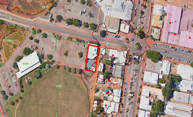
|
Item 9.2.4 - APPLICATION FOR RETROSPECTIVE DEVELOPMENT APPROVAL - PROPOSED SHOP
|
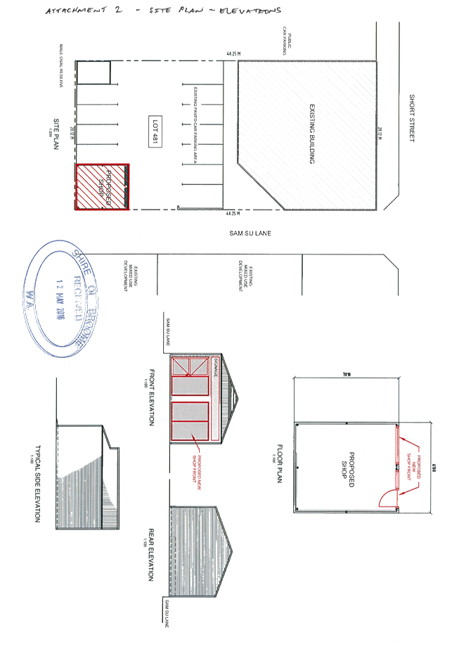
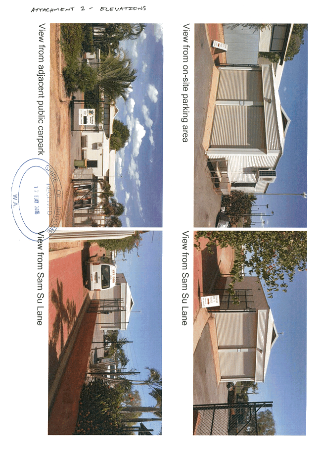
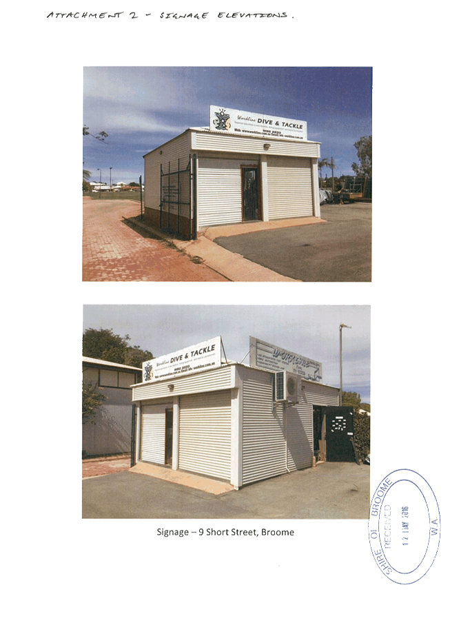
|
Item 9.2.4 - APPLICATION FOR RETROSPECTIVE DEVELOPMENT APPROVAL - PROPOSED SHOP
|
|
Consideration
|
Relevant Clause
LPS 6
|
Deemed Provisions
- Sub-Clause
|
Officer Comment
|
|
LAND USE
|
|
1
|
Scheme Aims
|
1.6
|
|
The application
satisfies the following aims of the Scheme:
1.6.3 Prosperity
(a) Assisting
employment and economic growth and providing opportunities for the
establishment of businesses;
|
|
2
|
Zoning / Reserve
Purpose & Objectives
|
4.4
|
|
The subject site is
zoned ‘Local Centre’ for which Clause 4.5 establishes the
following purpose and objectives:
4.4
Town Centre Zone
4.4.1
The purpose of the Town Centre Zone is to ensure that the area develops and
functions as the principal retail, activity and commercial centre for Broome
with retail, office, commercial, residential, social, recreational and
community facilities.
4.4.2
The objectives of the Town Centre Zone are to:
(a)
conserve and promote the heritage and aesthetic character and streetscape of
the Town Centre Zone;
(b)
encourage development in accordance with the development strategy and
relevant design guidelines.
(c)
provide for a mix of commercial activity including restaurants, bars and
residential development; and
(d)
encourage residential development within the Town Centre Zone compatible with
commercial uses to enhance the safety, vitality and diversity of the Town
Centre Zone.
The
‘Shop’ use is consistent with the above objectives for the
‘Town Centre Zone’.
|
|
3
|
Structure Plans /
LDPs / Special Control Areas
|
5.24 - 6.3
|
|
The subject site is
located within the Chinatown Development Strategy (CDS) area. The following
provisions of the CDS apply:
3.2.20
Town Centre
Chinatown
is designated as the Town Centre, reflecting the intention that it be the main
commercial centre for Broome. The Town
Centre
designation provides for retail, office, commercial, residential, social,
recreational and community facilities. The conservation and promotion of the
unique heritage, architecture, and aesthetics of the town centre is
reinforced by the Chinatown Development Strategy and Design Guidelines.
The
‘Shop’ as proposed will contribute to the commercial activation
of the town centre further to the provisions of the CDS.
|
|
4
|
Permissibility
|
4.17-4.28
|
Cl.67 (a), (b)
|
The development
proposed on site represents a ‘Shop’ land use which is a
‘P’ land use in the zoning table, meaning that the use is
permitted.
|
|
5
|
Orderly and Proper
Planning
|
LPS / Strategies
|
Cl.67 (a), (b)
|
Local Planning
Strategy
The subject site is
identified as a ‘Town Centre’ under the Local Planning Strategy.
The Strategy provides the following strategic direction for development
identified as ‘Town Centre’:
The development
provides a community facility and is consistent with the Local Planning Strategy.
|
|
DEVELOPMENT
|
|
6
|
Site and
Development Requirements
|
4.32 Schedule 15,
5.5-5.23
|
Cl.67 (a), (b)
|
Clause 4.32.1
prescribes the following site and development requirements for the Town
Centre zone:
4.32
Development in the Town Centre Zone
4.32.1
Site and Development Requirements:
(a)
All land use and development shall be consistent with the Chinatown
Development Strategy and relevant design guidelines.
The
application does not propose new development on-site and is therefore
consistent with the site and development requirements of Schedule 15 of LPS
6. Additionally, the application is consistent with the objectives and design
provisions of the CDS.
|
|
6.1
|
Setbacks
|
Schedule 15 / CDS
|
|
|
Schedule
15 – Development Standards – Town Centre
|
|
|
Scheme Requirement
|
Comment
|
|
Site Coverage (%)
|
Maximum 75%
|
The application
does not involve the addition of new built form floor-area and on this
basis the application will not alter existing site coverage. The
application complies with Site Coverage requirements.
|
|
Plot Ratio
|
Maximum 1.0
|
Complies.
|
|
Front Setback
|
Nil.
|
Complies
|
|
Secondary Street
Setback
|
Nil.
|
Complies
|
|
Rear Setback
|
* (Local
Government discretion)
|
Complies
|
|
Side Setback
|
Nil.
|
Complies
|
|
Special
Conditions/Comments
|
Landscaping along
street frontage within the road reserve is a requirement.
|
Existing
development on-site complies.
|
|
Building Height
|
10m wall height
|
Complies
|
|
14m building
height
|
Complies
|
|
Service Areas
|
Provision for
onsite storage areas, bin areas and general service areas for loading and
unloading of goods to be screened from view of the street.
|
An adequate,
screened, bin storage area has been shown on submitted plans.
|
|
Noise Control
|
Land uses which
have the potential to generate significant noise level due to machinery,
amplified music or announcements or any other ambient noise may be subject
of condition which require an acoustic report to be prepared by the
applicant and any noise attenuation controls recommended by the report to
be implemented.
|
The development
is not anticipated to have adverse impacts in terms of noise.
|
|
Broome-style
architecture
|
The building
style of all buildings within the Scheme Area are to be low scale of building
bulk and have regard for local climatic conditions and traditional
architecture features, including a pitched roof, single and hipped rook,
gables, colourbond roof, and predominant wall materials of colourbond or
timber.
Verandahs,
shutters and similar features should be included in development to reduce
solar penetration and increase access to prevailing breezes.
|
Complies. The
existing garage building to be used as a shop features materials reflective
of Broome’s architectural vernacular such as colorbond and gabled
roof design.
|
|
Access
|
Where development
is proposed that requires access to roads under the control of local
government the local government may control the location, number, size and
construction standards of local roads. Controlled access will apply to
arterial roads shown on the Scheme Maps.
|
Existing
cross-overs and vehicular access complies.
|
|
Public Art
|
In accordance
with LPP 8.20 – Provision of Public Art development is required to
contribute a monetary amount equal to one per cent (1%) of the estimated
total construction costs as indicated on the application for planning
approval, for the development of public art work to enhance the public
realm.
|
Not applicable to
current application (estimated development cost less than $2million).
|
|
Parking
|
Land within the
Scheme Area shall not be used or developed for any purposes unless car
parking bays, bicycle racks and motorcycle bays are provided on site in
accordance with Schedule 16.
Proposed /
Schedule 16
42sqm
‘Shop’ @ 1 bay per 25sqm = 2 bays
Existing
commercial floor-space previously approved to require the provision of 13
bays; meaning a minimum of 15 bays required on-site.
|
Variation. A
minimum 15 bays are required further to LPP 8.16 with 11 parking bays
proposed. As detailed in the ‘Comment’ section of the attached
report, a cash-in-lieu contribution for four (4) car parking bays is
required in accordance with LPP 8.19 – Cash-in-lieu of Car Parking
Chinatown.
|
|
Landscaping
|
When considering
an application, the local government is to determine whether any tree has
landscape significance and should be retained.
A landscaping
plan which details the retention of existing tree/s and proposed
landscaping on site and within the abutting road reserve may be required as
a condition of planning approval for developments.
|
Some existing
trees will be retained and incorporated into landscaping of the site. No
‘significant’ trees registered with respect the subject site.
Submitted landscaping plans indicate that adequate shading of parking bays
on-site and within road reserve will be achieved.
|
|
|
6.2
|
Plot Ratio
|
Schedule 15 / CDS
|
|
|
6.3
|
Site Coverage
|
Schedule 15 / CDS
|
|
|
6.6
|
Density
|
Schedule 15 / CDS
|
|
|
6.5
|
Landscaping
|
5.14/Schedule 15
|
|
|
6.5
|
Building Height
|
5.11
|
|
|
6.7
|
Car Parking
|
5.7
|
|
|
6.8
|
Service Areas
|
5.8
|
|
|
6.9
|
Noise
|
5.9
|
|
|
6.10
|
Architecture
|
5.12
|
|
|
6.11
|
Public Art
|
LPP 8.20
|
|
|
6.12
|
Access
|
5.10
|
Cl.67 (s)
|
|
Compatibility
|
|
7
|
Compatibility,
Amenity and Relationship with Adjoining Land
|
Consider Site and
Dev. requirements
|
Cl.67 (m), (n)
|
The subject site
features an existing ‘Office’ on-site. The proposed development
is consistent with a ‘Community Purpose’ and ‘Office’
land-use, both of which are ‘Permitted’ uses within the
‘Local Centre’ zone. The use as proposed is not expected to be of
an intensity incompatible with adjoining residential areas. The development
complies with all site and development requirements relating to built form,
and on this basis is not expected to generate adverse impacts upon adjoining
residential land from a ‘built form scale’ perspective.
|
|
8
|
Heritage
|
Part 7
|
Cl.67 (k)
|
The subject site is
located within the State Heritage Listed Chinatown Conservation Area and was
referred to the State Heritage Office for comment with no objections to the
proposal received.
|
|
9
|
Cultural
Significance
|
|
Cl.67 (l)
|
The subject site is
not known to have any cultural significance and standard advice notes in this
regard regarding the need to ensure compliance with the Aboriginal
Heritage Act 1972 will be included in development approval.
|
|
10
|
Social Issues and
Community Services
|
|
Cl.67 (v), (x)
|
The subject
development is not considered likely to cause adverse social issues and, as
detailed in the applicants rationale in support of the proposal; is likely to
contribute to the activation of Sam Su Lane which in turn may assist towards
deterring anti-social behaviour.
|
|
11
|
Natural Environment
& Drainage
|
|
Cl.67 (o)
|
N/A
|
|
12
|
Natural Hazards
|
|
Cl.67 (q)
|
The subject site
does not fall within an existing Flood Prone Land Special Control Area. Given
the RL level of the site, is it not likely to be affected by inundation.
|
|
13
|
Access and Traffic
|
|
Cl.67 (s)
|
Complies. Existing
vehicular access arrangements allowing vehicles to enter directly onto Short
Street, or alternatively via Sam Su Lane or via the Broome Visitor Centre
carpark.
|
|
14
|
Public Utilities
|
|
Cl.67 (u)
|
The site has
adequate access to public utilities to support this development.
|
|
Consultation
|
|
|
|
|
15
|
Submissions &
Anything Else
|
9.4
|
Cl.67 (y) (zb)
|
The application is
a ‘P’ land use. In accordance with LPP 8.23 – Public
Consultation – Planning Matters, the application does not require
public consultation.
|
|
9.2.5 Draft Recreation Trails
Masterplan and Recreation Trails marketing plan for the Shire of Broome
townsite
LOCATION/ADDRESS: Nil
APPLICANT: Nil
FILE: RFQ
16-26
AUTHOR: Club
Development Officer
CONTRIBUTOR/S: Nil
RESPONSIBLE
OFFICER: Deputy
Chief Executive Officer/Director Community & Economic Development
DISCLOSURE
OF INTEREST: Nil
DATE OF REPORT: 7
July 2016
|
|
SUMMARY: This
report presents the Draft Recreation Trails Masterplan for the Shire of
Broome town site prepared by UDLA for Council’s consideration. The
report recommends that the Masterplan and associated Marketing Plan be
endorsed by Council for advertising to seek public comment and feedback.
|
BACKGROUND
Previous
Considerations
Nil
Over the past five years there have
been a number of plans developed by the Shire of Broome that reference the need
to provide improved connectivity between destinations across the town site.
Among the documentation developed was the Shire of Broome’s Local
Planning Strategy. The Strategy was adopted by the Western Australian Planning
Commission in 2014. The Strategy considers future growth and sets out land use
planning direction for the Shire over the next 10-15 years.
Section 2.4.9 – Open Space
Strategy contains the following strategy action:
· Strategy 11:
Provide for an integrated network of walkways and trails.
· Action: Develop a
trails masterplan for the Shire.
An allocation of $15,000 was
contained in the 2015/16 budget to develop a Trails Masterplan for the Broome
townsite. In addition, $25,000 of funding was successfully sought from the
Department of Sport and Recreation’s Lotterywest Trails Grant program in
October 2015, resulting in an allocation of $40,000 for this project.
Funding was received in March 2016
and consultants were appointed in April with a focus on three key areas:
1. Outline
a long term strategy for the development of pathways, tracks and trails to
connect existing and proposed destinations including housing estates, schools,
parks, key sporting, tourism, cultural and shopping destinations.
2. Identification
of potential nodes and tracks to develop recreational activities including BMX,
mountain bike and personal training, running and triathlon circuits.
3. Recommendations
around marketing strategies to promote site/trails.
Council is now requested to consider
endorsement of the Draft Recreation Trails Masterplan and Recreation Trails
Marketing Plan for advertising for the seeking of public comment.
COMMENT
The attached documentation for
Council’s consideration includes a Recreation Trails Masterplan for
Shire-owned land within the Shire of Broome town site. This plan includes
costings, a proposed staging plan, funding options and recommends priority projects.
A recreation trails marketing plan
has also been developed. It is widely acknowledged good promotion of trails is
an essential part of ensuring maximum usage. The document attached for
Council’s consideration provides recommendations on how the Shire of
Broome could best promote any potential trail.
The marketing plan provides examples
of six key trails that have the potential to be created should relevant
recommendations in the masterplan be actioned. Cost estimates have also been
included. It is noted that three of the trails could be developed with minimal
infrastructure costs, yet would have a positive impact on the community
by improving connectivity between key recreational, commercial and cultural
centres. These include a 6.5km Cable Beach to Chinatown trail, a 15km
Neighbourhood Trail and a 5.5km Bay to Banu trail.
The strategies included in the
document could be applied to any potential trail developed in future, and
provides opportunity to include the community through the design and creation
elements.
It is intended the Draft Recreation
Trails Masterplan will be an informing strategy within the Integrated Planning
and Reporting Framework. Council is due to undertake a full review of its
Strategic Community Plan and Corporate Business Plan in 2016/17 and could
consider including some of the identified priority projects for progression,
subject to financial constraints.
CONSULTATION
Early in the process it was agreed
that the project would focus on the Shire of Broome town site, and on land
owned by the Shire of Broome. Any proposed developments on external land tenures
were considered, with a view of providing opportunities to connect with them in
future.
The first stage of the project
focussed on reviewing related documentation including:
· Draft Cable Beach
Development Strategy Part 1. (Shire of Broome 2016)
· Corporate Business
Plan 2015-2019. (Shire of Broome 2015)
· Shire of Broome
Framework for the development of sport and recreation facilities 2016-2025.
(Shire of Broome 2015)
· It starts with
you: Shire of Broome Youth Framework 2016-2018 Draft. (Shire of Broome 2015)
· Western Australian
Mountain Bike Management Guidelines. (West Australian Mountain Bike Management
Guidelines Working Group (2015)
· Broome Speedway
and Motocross Relocation Study: Business Case and Masterplan. (AECOM and Cardno
2015)
· Sport Recreation
and Leisure Plan (CCS Strategic 2014)
· Old Broome
Development Strategy and Concept Plan for Town Beach and Conti Foreshore Part 1
(Cardno 2014)
· Shire of Broome
Local Planning Strategy Part 1 and 2 (Shire of Broome endorsed by WAPC 2014)
· Long Term
Financial Plan 2015-2030 (UHY Haines Norton Chartered Accountants 2014)
· Broome Coastal
Reserves Master Plan (CCS, ASE and UDLA 2013)
· The Department of
Environment and Conservation, Yawuru Conservation Parks DRAFT Recreation
Masterplan, (DPaW for NBY 2013)
· Chinatown
Development Strategy (Hassell 2012)
· Broome North
District Development plan – Rev D (CODA 2010)
· Business Case for
Broome Jetty to Jetty Roebuck Bay Coastal Walk (Hames Sharley 2014)
During the period 20 May 2016 to 27
May 2016 five workshops were held with key stakeholders including key Shire of
Broome officers, Department of Sport and Recreation regional staff, Nyamba Buru
Yawuru, Department of Parks and Wildlife, Landcorp, the Broome Museum and
Broome Historical Society. A community workshop attracted 14 members of the
public with a further 11 people providing comment via email.
The draft report is now presented to
Council for consideration. It is proposed that should Council endorse the Plan
for advertising, the Shire will directly advise workshop participants of the
public submission period. The proposed key milestones to finalise the plan
follow:
|
Action
|
Date
|
|
Recreation Trails Master Plan and
Recreation Trails Marketing Plan presented to Council for endorsement and
documents released for public comment for a period of four weeks
|
28
July 2016
|
|
Release the draft plan for public
comment for a period of four weeks.
|
4
August 2016
|
|
Close public comment/consultation
period.
|
31
August 2016
|
|
Feedback reviewed and considered
and Consultants to present findings at Council workshop
|
20
September 2016
|
|
Recreation Trails Masterplan and
Marketing Plan presented to Council for adoption.
|
29
September 2016
|
STATUTORY ENVIRONMENT
Local Government Act 1995
Division 3 – Executive functions
of local governments
Subdivision 1 -3.18 Performing
executive functions
(3) A local
government is to satisfy itself that services and facilities that it provides
–
(a) integrate
and coordinate, so far as practicable, with any provided by the Commonwealth,
the State or any public body; and
(b) do
not duplicate, to an extent that the local government considers inappropriate,
services or facilities provided by the Commonwealth, the State or any other
body or person, whether public or private: and
(c) are
managed efficiently and effectively.
POLICY IMPLICATIONS
5.1.10 Community Engagement
FINANCIAL IMPLICATIONS
Implementation of the Recreation
Trails Masterplan is not included in the current Long Term Financial Plan
(LTFP). Should Council choose to endorse the plan it will become an informing
strategy to be considered for incorporation into the LTFP when it is next
reviewed.
The projects listed below are
prioritised in order of importance for tracks and trails within the Broome town
site however it should be noted that implementation of these projects will be
dependant on the competing priorities from other capital/renewal items and will
be subject to resource capability/allocation through the annual budget process.
Some of the projects are aligned to
existing Shire plans including the Draft Cable Beach Development Strategy and
the “Youth Precinct” concept contained within the BRAC masterplan.
The projects that are prioritised in
the Masterplan as Stage 1, High Priority (0 – 5 years) are as follows:
Item
|
Description
|
Cost
|
Type
|
|
1a
|
Construct dual use pathway on east
side of Gubinge Road
|
$240,000
|
Upgrade
|
|
2a
|
Construct dual use path on west
side of Old Broome Highway cause way
|
$170,000
|
New
|
|
5
|
Masterplan BRAC to explore options
for youth orientated facilities
|
$30,000
|
-
|
|
7
|
Masterplan Cable Beach to include
exercise equipment, bike racks and bicycle repair facilities
|
$70,000
|
-
|
|
9
|
Path upgrade – Clear and
maintain path through the ECC, south of Banu Avenue
|
$7,000
|
Upgrade
|
|
10
|
Repair damaged path and address
drainage issues at end of Reid Road and Dakas Street
|
$66,000
|
Renewal
|
|
11
|
Install lights along path between
cemetery and St Mary’s College
|
$62,000
|
Upgrade
|
|
12a
|
Install lights & trees on the
north side of paths, south side of Sanctuary Road between Cable Beach Road
West & Oryx Road
|
$164,000
|
Upgrade
|
|
12b
|
Shade trees on the north side of
paths, south side of Sanctuary Road between Oryx Rd and Fairway Drive
|
$20,000
|
Upgrade
|
|
21
|
Add bike rack in China town
|
$5,000
|
New
|
|
22
|
Add bike rack and skateboard fixing
station at BRAC skate park
|
$28,000
|
New
|
|
23
|
Add bike rack, water fountain, bike
fixing station and exercise equipment at BRAC ovals
|
$50,000
|
New
|
|
24a
|
Install exercise equipment at Surf
Club end of Cable Beach
|
$17,000
|
New
|
|
24b
|
Install bike rack, water fountain,
exercise equipment at Zanders end of Cable Beach
|
$17,000
|
New
|
|
29
|
Promote path network as per
marketing plan attached
|
-
|
-
|
|
|
Total cost
|
$946,000
|
|
The Masterplan identifies external
funding opportunities that exist and could potentially part fund a number of
these priorities. Further investigation will be required upon completion of the
masterplan to clarify these funding opportunities.
The masterplan also outlines costings
for Stage 2 Medium Priority (5-10 years) and stage 3 Low Priority (10-15
years). These can be viewed on page 26 and 27 of the masterplan.
Funding
Sources:
The Broome Recreation Trails Masterplan includes an
extensive list of potential funding options that officers can investigate for
projects seen as priorities. These can be viewed on page 31 of the Masterplan.
RISK
|
Option
|
Risk
|
Risk Rating
|
|
1
|
Council endorse the draft
Recreation Trails Masterplan
|
Community expectation will be that
there are sufficient funds available to implement the works/trails
recommended.
|
Low
|
|
2
|
Council do not endorse the draft
Recreation Trails Masterplan.
|
Shire of Broome has no planning
around developing recreation track, trails and destinations nodes.
|
High
|
|
Areas of town continue to be
vulnerable to anti-social behaviour.
|
High
|
STRATEGIC
IMPLICATIONS
Our People
Goal – Foster a community environment that is accessible, affordable,
inclusive, healthy and safe:
Affordable services and initiatives
to satisfy community need
Accessible and safe community spaces
Participation in recreational and
leisure activity
A healthy and safe environment
Our Place
Goal – Help to protect the nature and built environment and cultural
heritage of Broome whilst recognising the unique sense of the place:
Realistic and sustainable land use
strategies for the Shire within state and national frameworks and in
consultation with the community
A unique natural environment for the
benefit and enjoyment of current and future generations
A preserved, unique and significant
historical and cultural heritage of Broome
Core asset management to optimise
Shire’s infrastructure whilst minimising life cycle costs.
Our
Prosperity Goal – Create the means to enable local jobs creation and
lifestyle affordability for the current and future population:
Affordable and equitable services and
infrastructure
Our
Organisation Goal – Continually enhance the Shire’s organisational
capacity to service the needs of a growing community:
Effective community engagement
VOTING REQUIREMENTS
Simple Majority
|
REPORT
RECOMMENDATION:
That Council receives the DRAFT Broome
Recreational Trails Masterplan and DRAFT Broome Recreation Trails Marketing
plan and requests the Chief Executive Officer to advertise the documents to
seek community feedback for a period of four weeks and present any
submissions to Council for future consideration.
|
Attachments
|
1.
|
DRAFT Broome
Recreational Trails Masterplan
|
|
2.
|
DRAFT Broome
Recreational Trails Marketing Plan
|
|
Item 9.2.5 - Draft Recreation Trails Masterplan and
Recreation Trails marketing plan for the Shire of Broome townsite
|
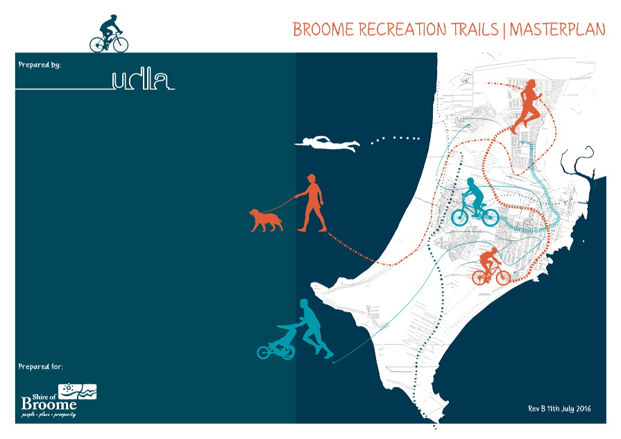
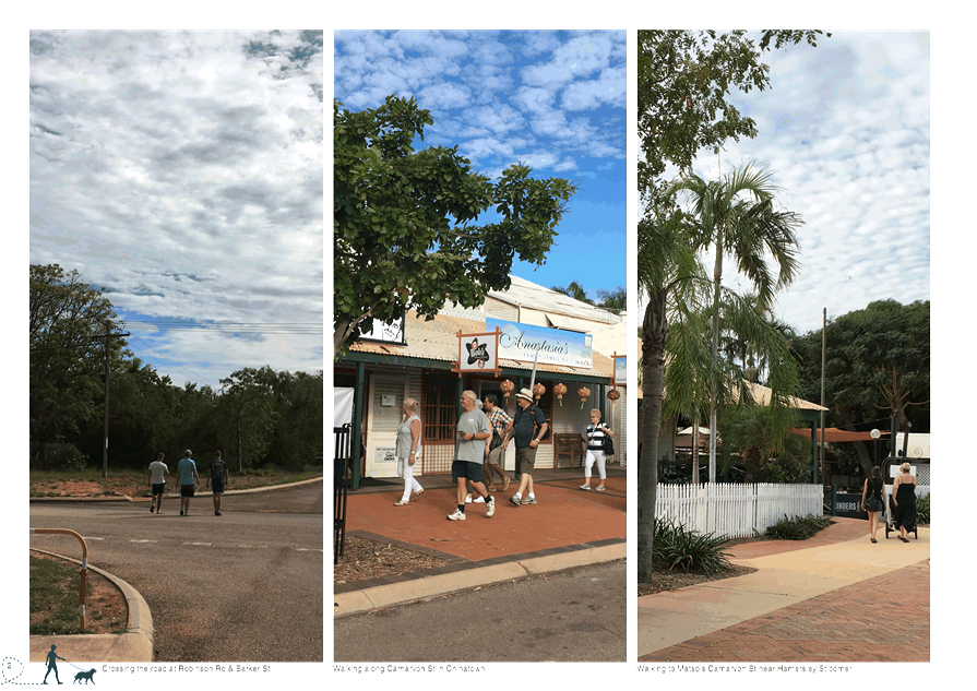
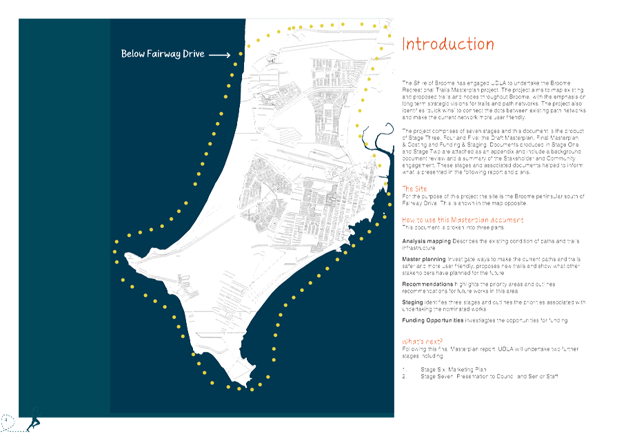
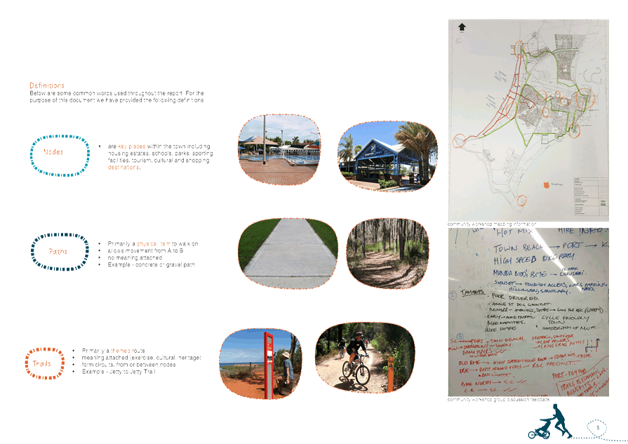
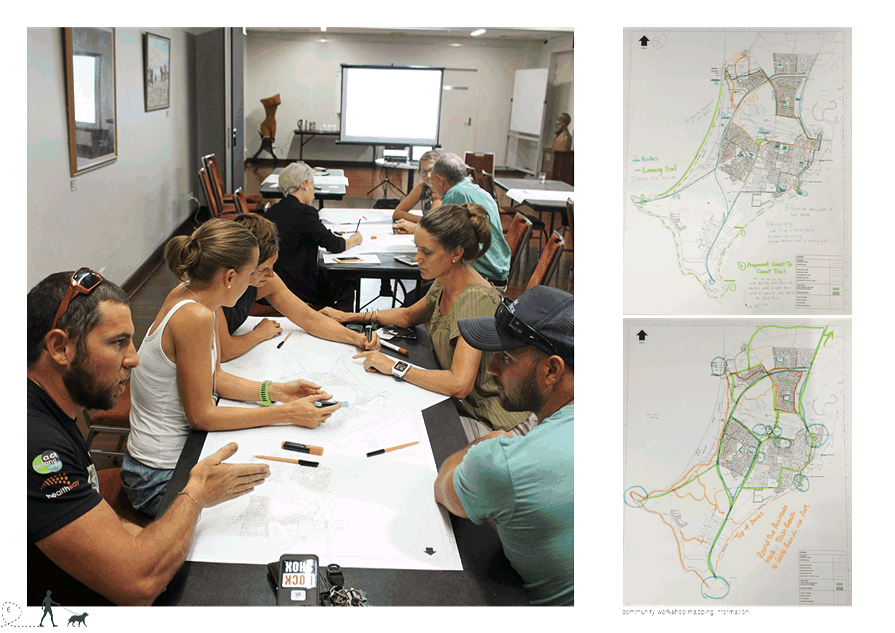
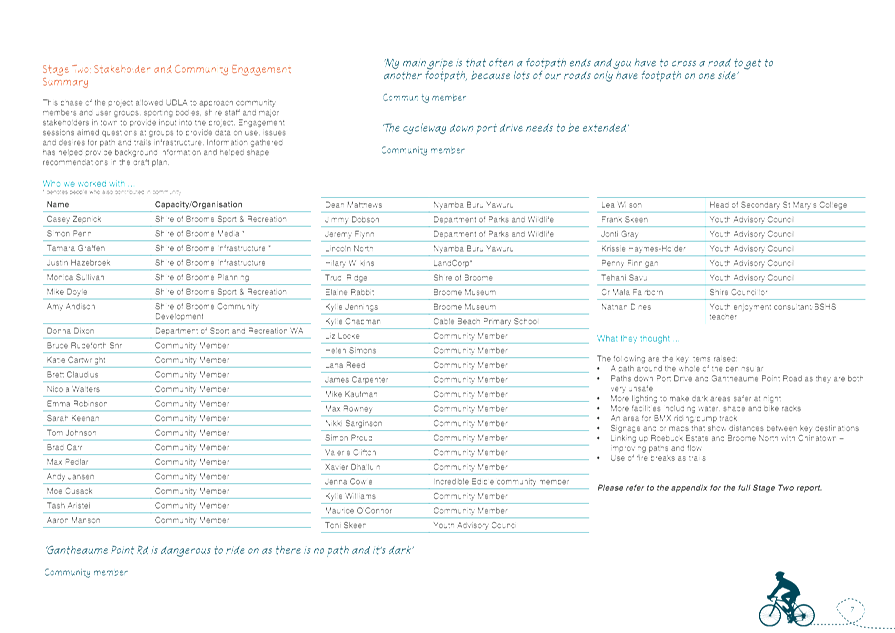
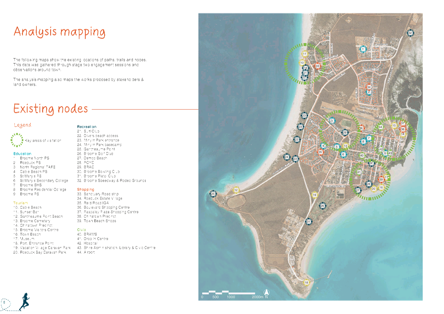
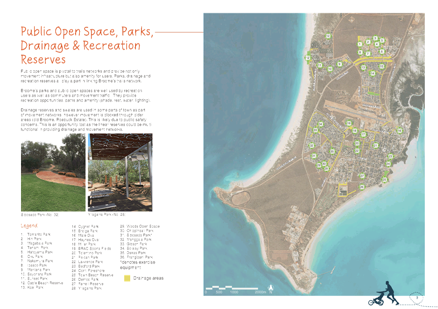
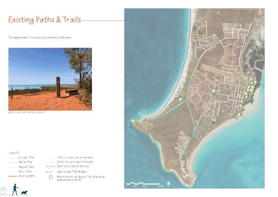
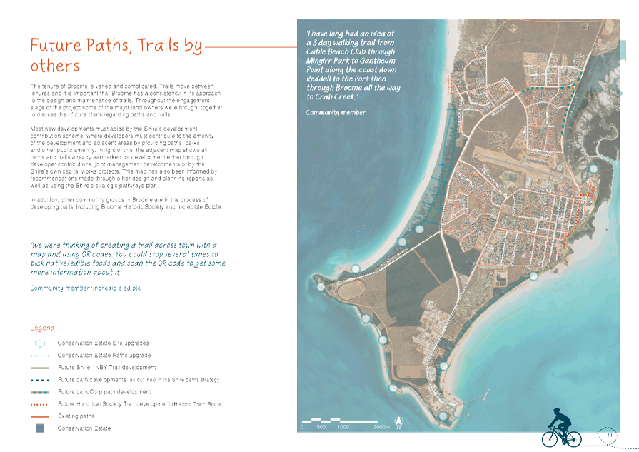
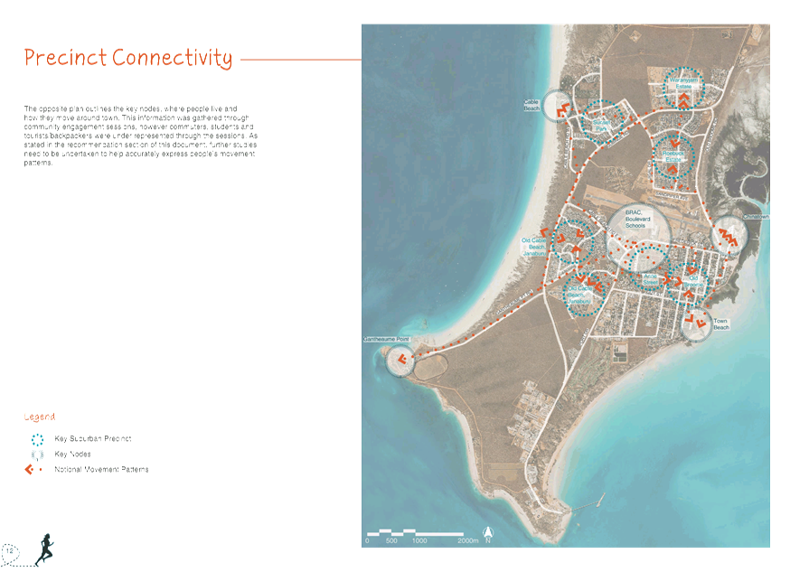
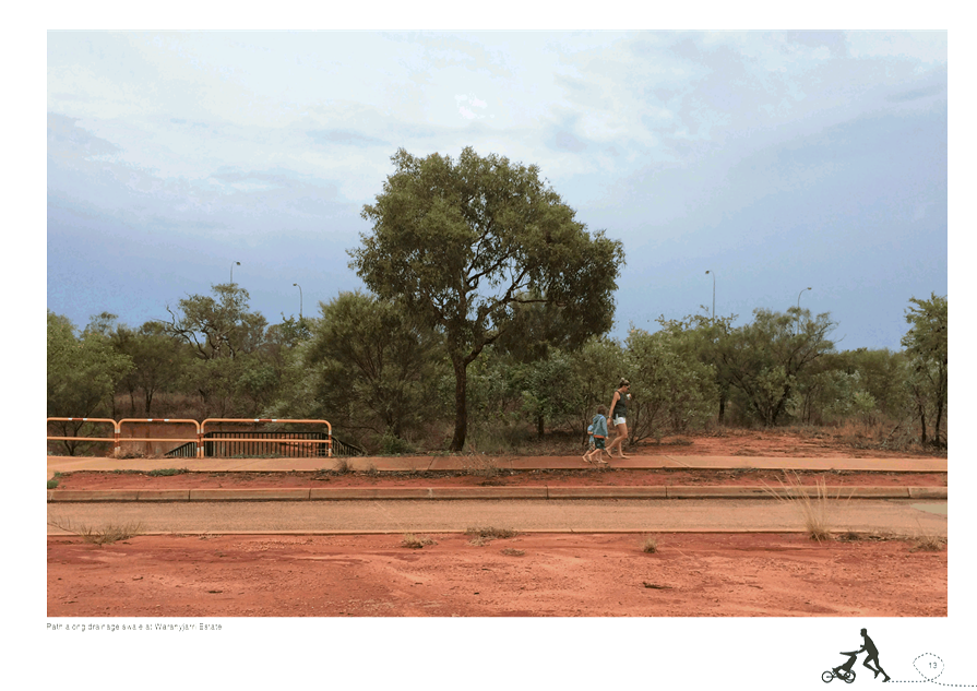
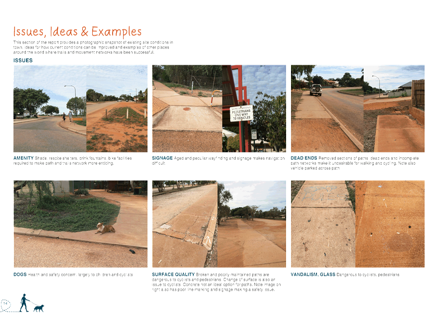
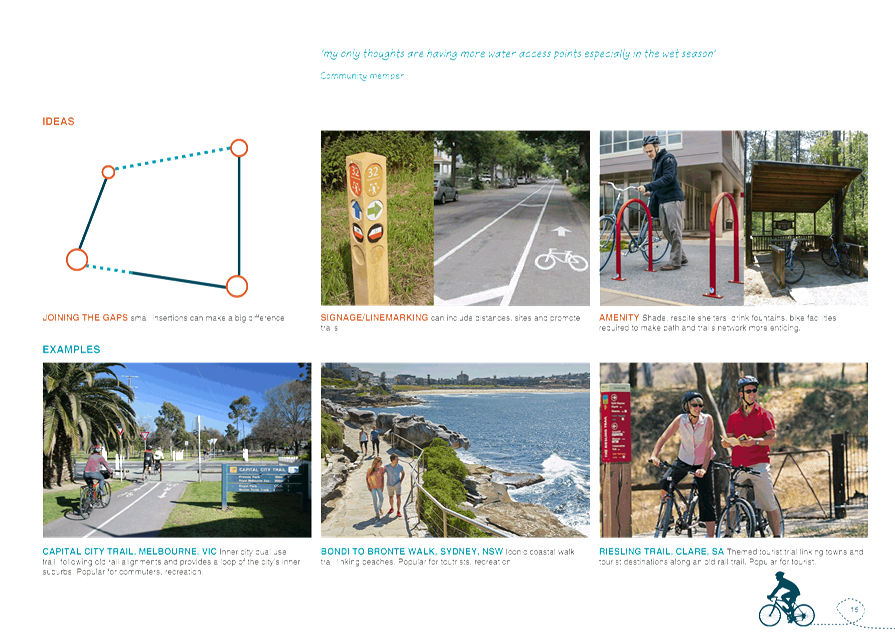
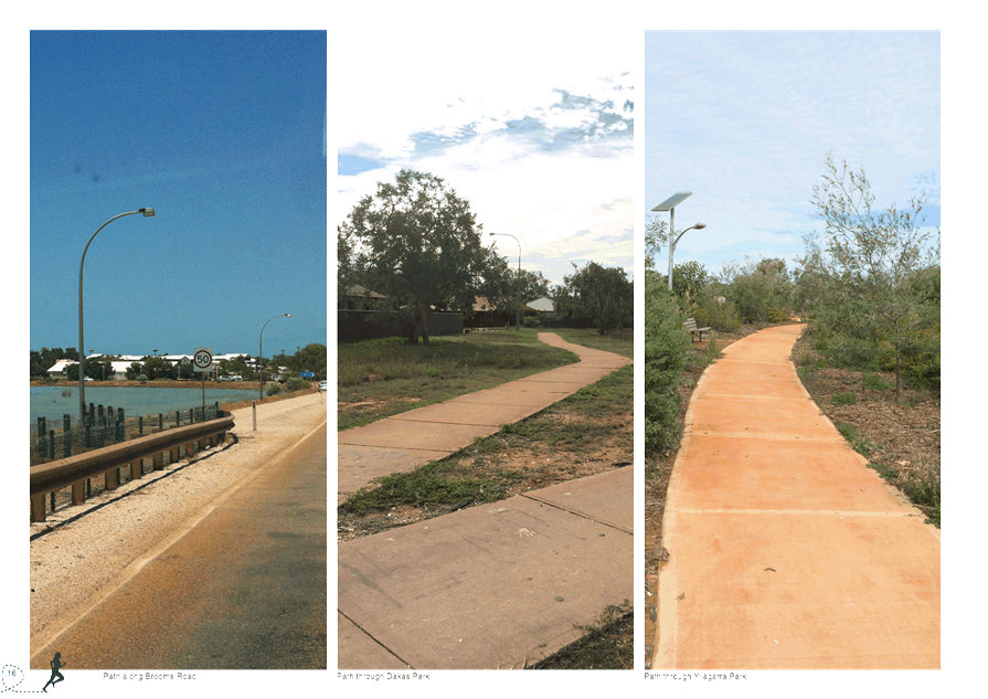
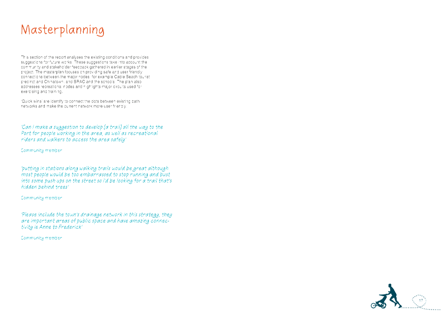
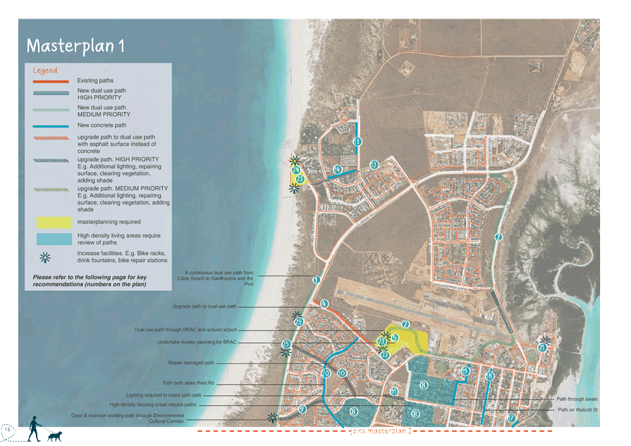
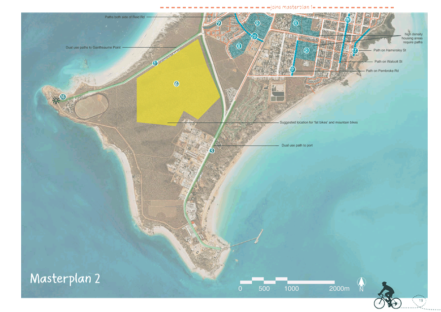
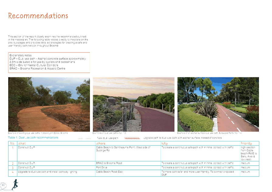

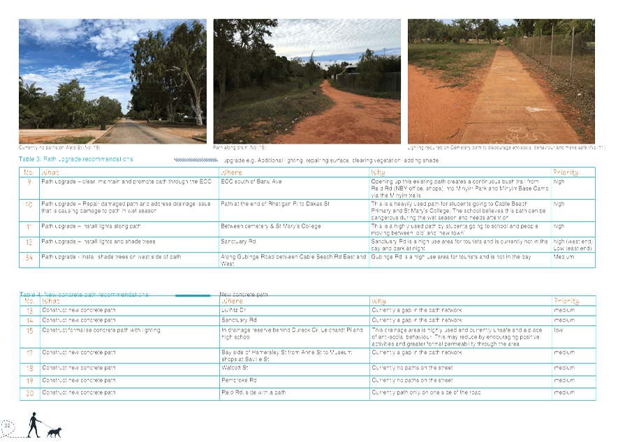
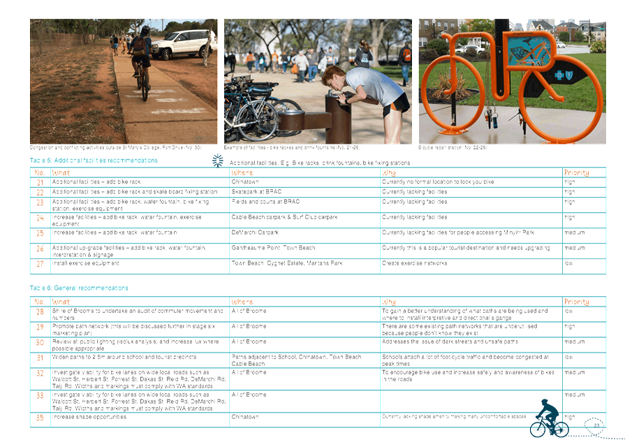
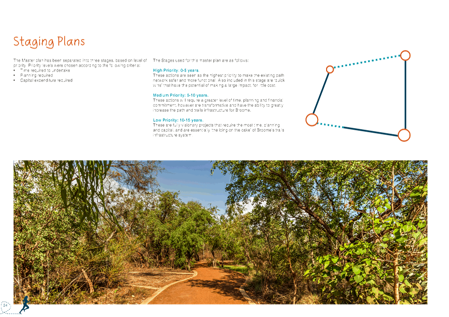
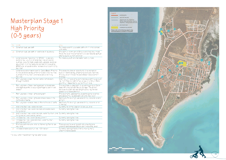
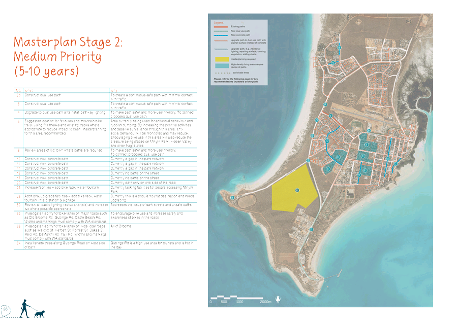
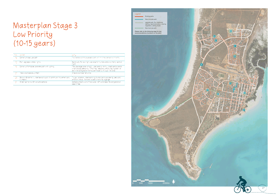
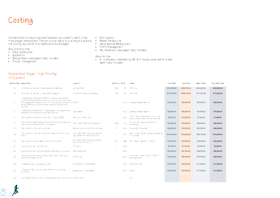
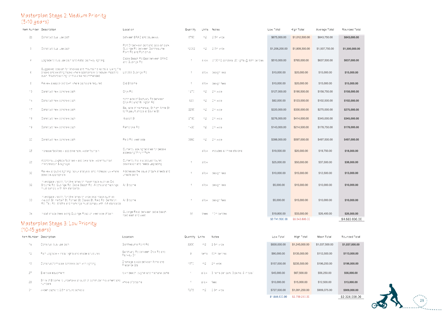
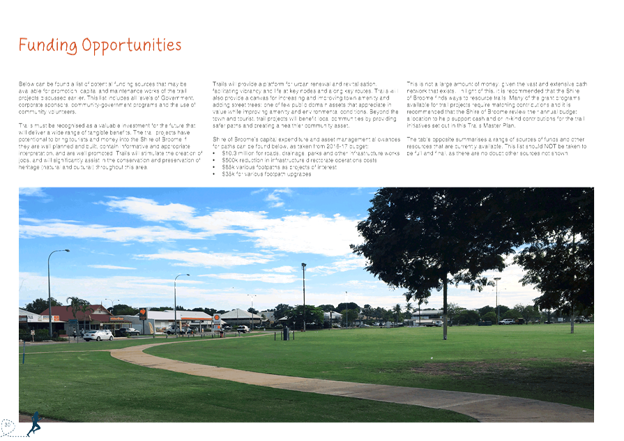
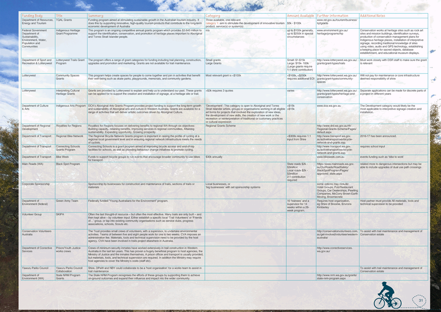
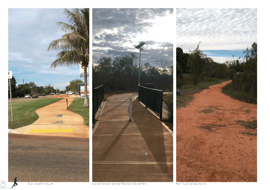


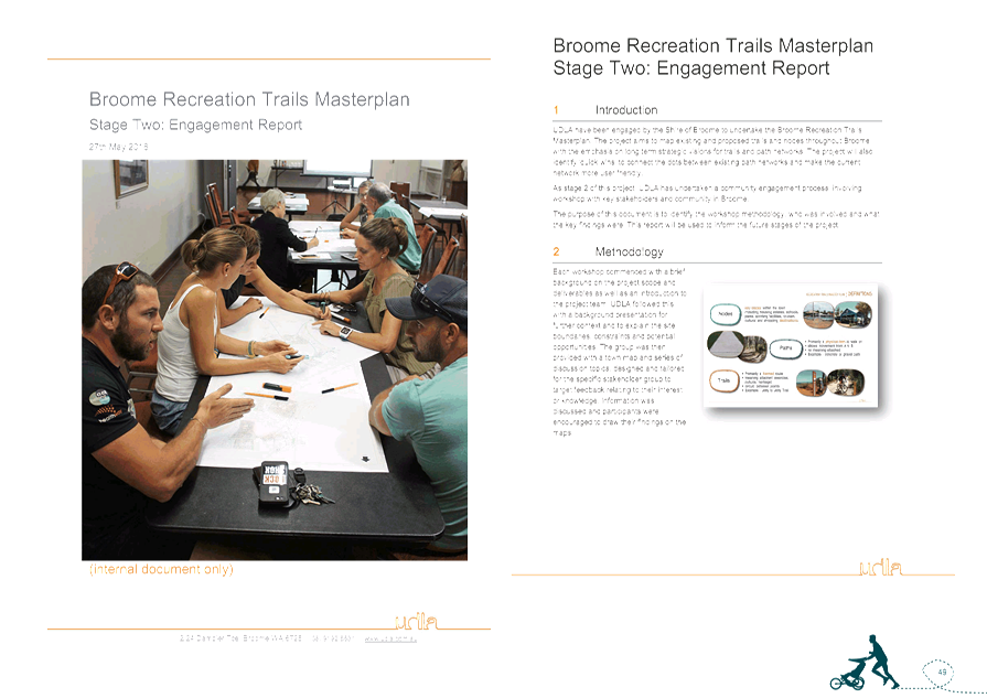
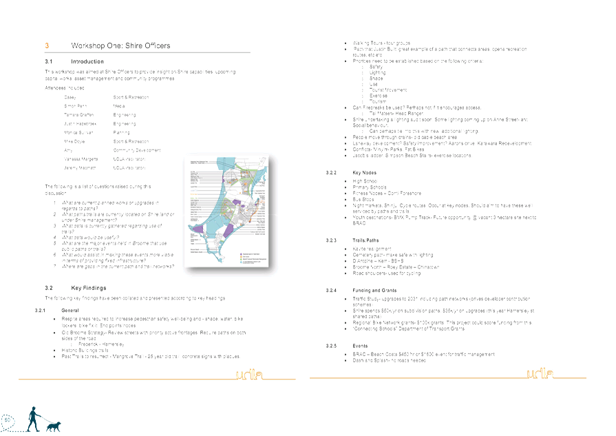
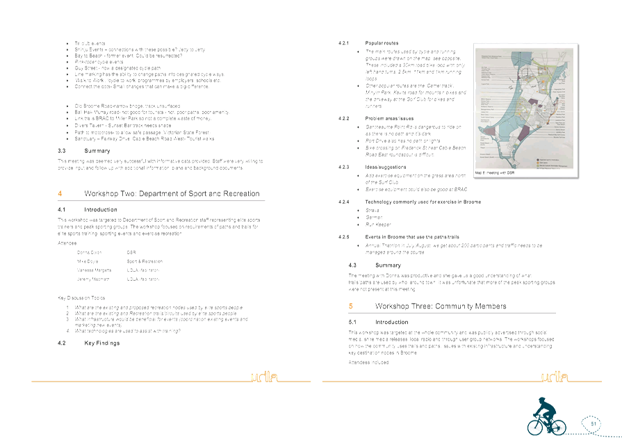
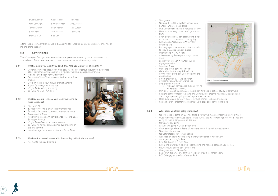
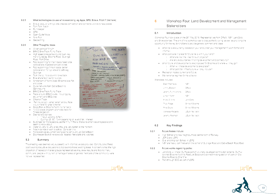

|
Item 9.2.5 - Draft Recreation Trails Masterplan and Recreation Trails marketing
plan for the Shire of Broome townsite
|
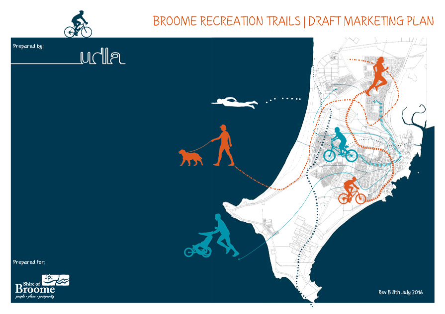
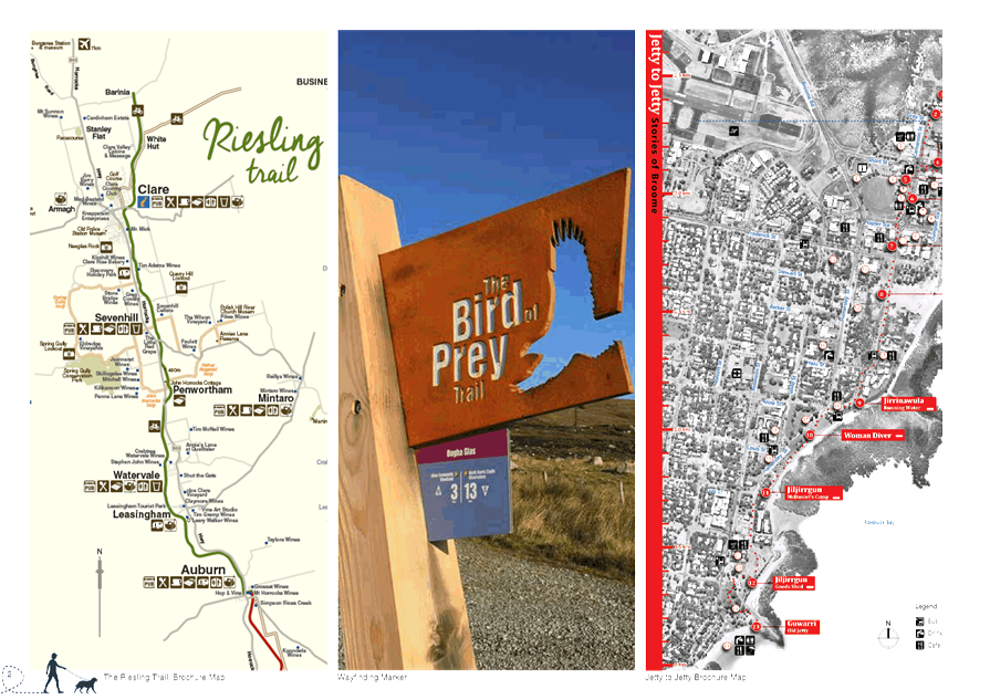

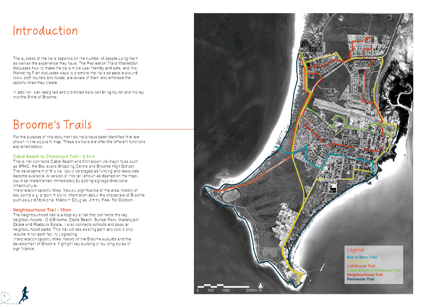
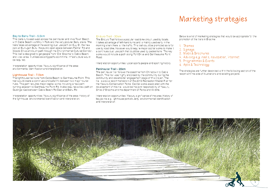
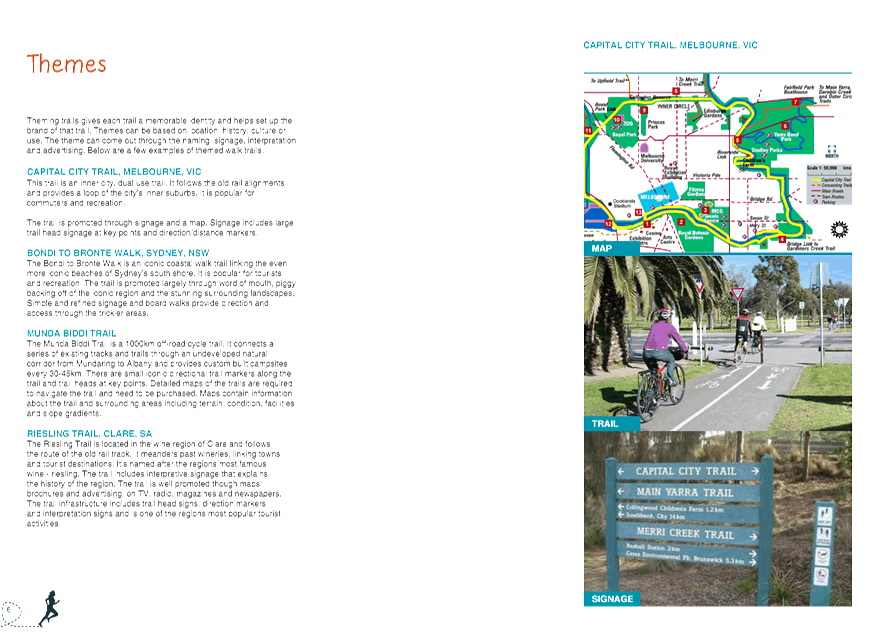
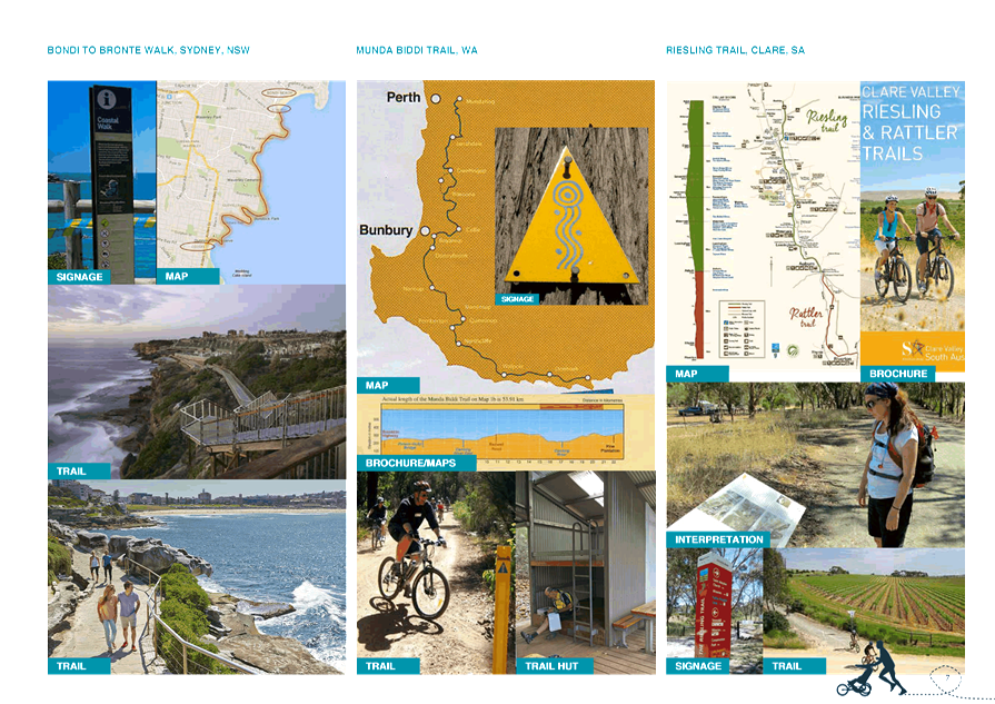
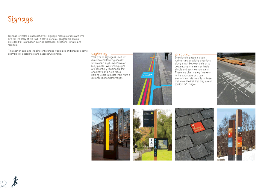
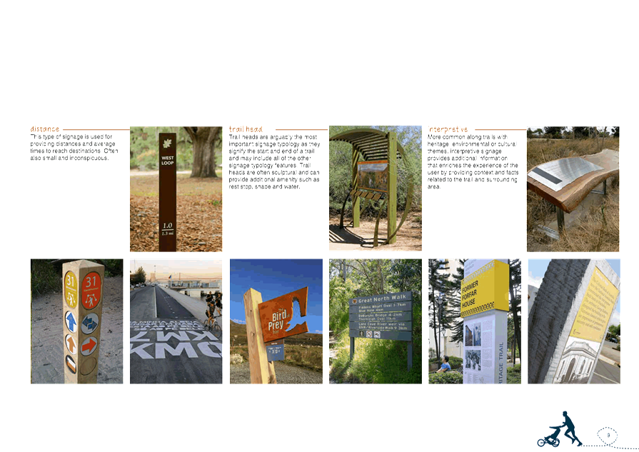
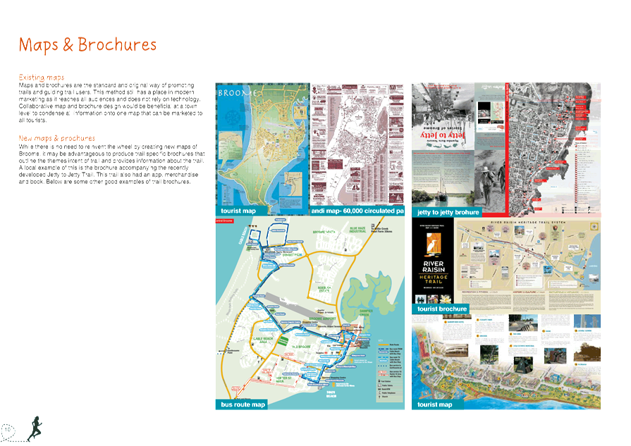
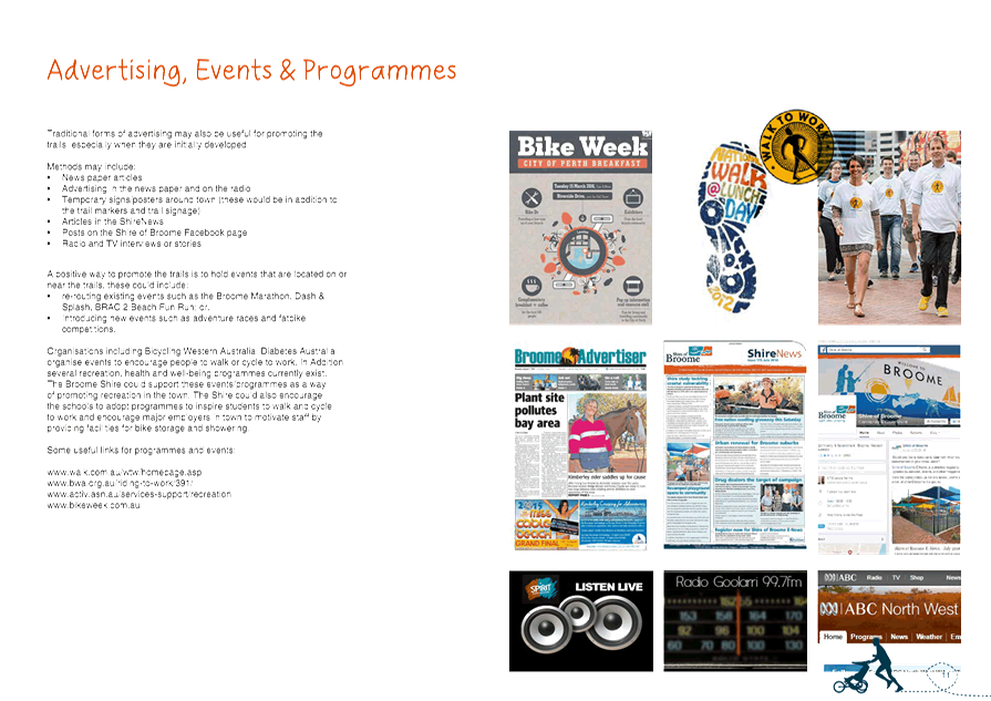
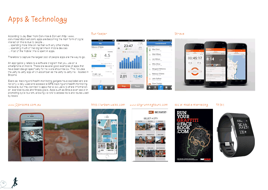
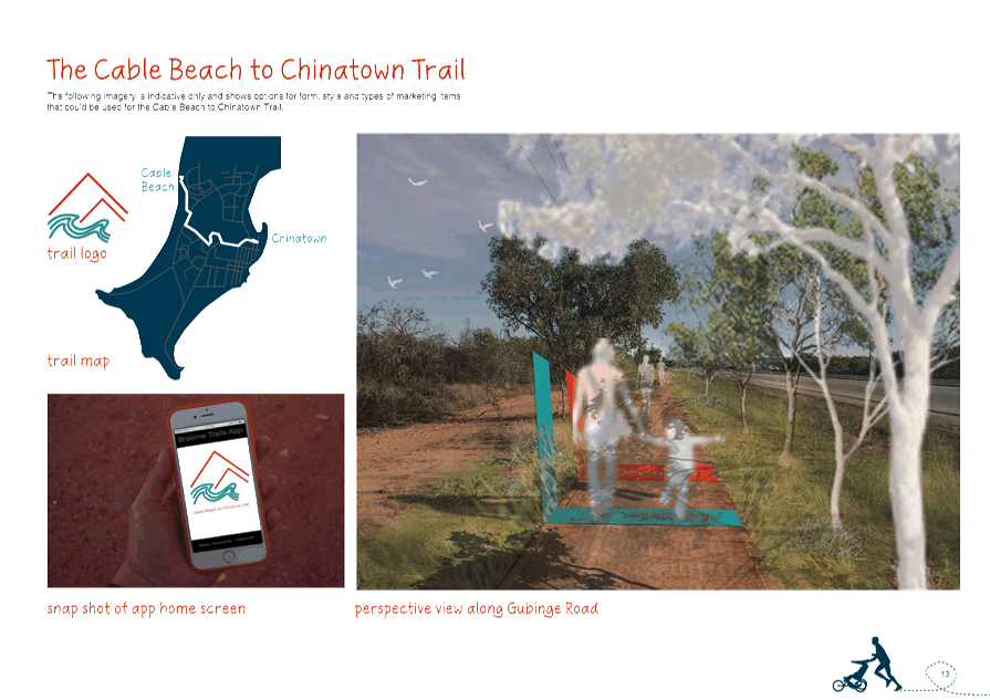
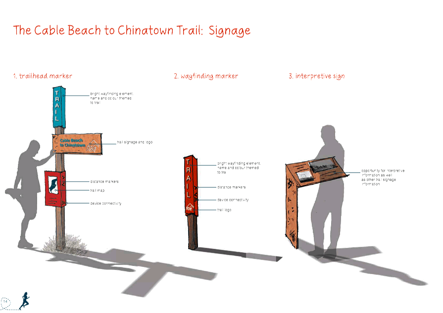
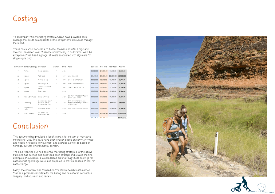

|
9.2.6 REVIEW OF LOCAL PLANNING
POLICY 8.20 - PROVISION OF PUBLIC ART
LOCATION/ADDRESS: Nil
APPLICANT: Shire
of Broome
FILE: PLA91
AUTHOR: Statutory
Planning Coordinator
CONTRIBUTOR/S: Manager
Community Development
RESPONSIBLE
OFFICER: Director
Development Services
DISCLOSURE
OF INTEREST: Nil
DATE OF REPORT: 12
July 2016
|
|
SUMMARY: This
report presents the outcome of a review of LPP 8.20 – Provision of
Public Art (LPP 8.20). Following the review of LPP 8.20, it is
recommended that Council adopt a minor amendment to the Policy which changes
the amount of the required public art contribution from 1% of the estimated
development cost to 0.5%.
|
BACKGROUND
Previous
Considerations
OMC 16 May 2013 Item
9.2.4
OMC 19 September 2013 Item
9.2.4
OMC 30 July 2015 Item
9.2.3
OMC 17 December 2015 Item
9.4.3
SMC 19 January 2016 Item
6.2.3
Background
LPP 8.20 was formally adopted by
Council at the Ordinary Meeting of Council (OMC) on the 19 September
2013. More recently, LPP 8.20 was reviewed at the July 2015 OMC (as a part of
the review of all Local Planning Policies following the gazettal of Local
Planning Scheme No. 6) and the December 2015 OMC (as a part of the review of
all Shire policies).
While some minor modifications were
undertaken to LPP 8.20 at the July 2015 OMC, the policy has essentially remained
unchanged since it was adopted in 2013. The modifications made at the July 2015
OMC were limited to:
- Amending
Policy Statement 1.1 to allow for the contribution to be satisfied as either a
monetary contribution or installation of public art work on-site or within
proximity of the site (the previous version of LPP 8.20 emphasised that it
should be a monetary contribution).
- Amending
Policy Statement 1.2 to require the contribution to be ‘made’, as
opposed to an invoice being issued.
- In
response to the preparation of the ‘Guidelines for the Provision of
Public Art’ by the Community Development Services Section, amending
Policy Statement 1.3 to include criteria that must be satisfied if public art
is proposed to be installed onsite or immediately adjacent to the site.
- Inclusion
of a provision setting out that art built in accordance with LPP 8.20 is
considered minor development and will not need development approval from the
Shire.
No amendments were made to LPP 8.20
as a part of the Shire policy review presented to Council at the December 2015
OMC.
In response to Councillor concerns
that LPP 8.20 may be onerous in the current economic climate, the policy was
listed for consideration at the Special Meeting of Council on 19 January 2016.
No amendments were made to LPP 8.20 at this meeting.
The Development Services Directorate
is undergoing a review of all of its Policies, Local Planning Policies and
Local Laws. As part of this review, workshops have been held with Council
and discussions have occurred internally between Shire staff regarding the
provisions of LPP 8.20.
This report provides an overview of
the outcome of the review of LPP 8.20.
COMMENT
LPP 8.20 was developed in recognition
of the capacity of art to connect people to place and to instil a sense of
shared community. In general, it is understood that by fostering a sense of
place and enhancing the character of an area, public art is able to play a role
in contributing towards economic development. This is particularly relevant to
Broome, where the attractiveness of place is inextricably linked to tourism
numbers and associated investment.
As set out in the background section
of LPP 8.20, the installation of public art helps achieve the following aim of
Local Planning Scheme No. 6:
1.6.1 Place
(f) Safeguarding
and enhancing the character and amenity of the built environment and urban
spaces of the Scheme area.
The review of LPP 8.20 has involved
reviewing other local government public art policies and also State
Administrative Tribunal (SAT) determinations on this subject.
With regard to how other local
governments have sought to fund public art, there are a number of different
approaches, including:
- Percentage
of rates: Some local governments levy a percentage of rates which then goes
towards the project management and commission fees for the creation and
installation of public art. Current practice has set this sort of levy in the
vicinity of 0.75% to 1.0%.
- Percent
for art contribution: Some local governments fund public art via a Percent
for Art contribution policy, which secures contributions from a local
government’s capital works towards the ongoing provision of public art in
the region.
- Percent
for art developer contributions: Such policies can be tailored to capture
contributions from certain development likely in a region; i.e. local
governments can define a threshold of development cost from where the policy
becomes valid, the types of development covered by the policy and other factors
which balance the desire to support economic growth within a region whilst
maintaining funding for contributions to the cultural infrastructure of public
art.
- Voluntary
contributions via development incentives: Voluntary contributions are
encouraged by some local governments through offering development incentives in
return for a developer providing public art within their development. These
planning incentives vary, depending on the planning requirements for a
location, but may include increases in allowable building height, plot ratios,
etc.
The table below shows the policies of
other local governments in Western Australia (please note this does not cover
all local governments which have public art policies, it is just a general
overview):
|
Local
Government
|
Policy
Position
|
|
Subiaco
|
Private
developers of commercial and mixed use developments are expected to
contribute to public art in accordance with estimated construction cost. The
method of calculating the public art contribution is based upon the
City’s Development Approval fee schedule as follows:
|
Value
of Construction
|
Value
of Contribution
|
|
$1,000,001
> $1.5 million
|
$10,000
|
|
$1,500,001
> $2 million
|
$15,000
|
|
$2,000,001
> $2,499,999
|
$20,000
|
|
$2.5
million +
|
One
percent of the construction cost
|
|
$15
million
|
Contribution
cap negotiated (no less than $250,000).
|
|
|
Belmont
|
Developments
over the value of $4.5 million are required to provide 1% of the estimated
development costs as a contribution.
|
|
Greater Geraldton
|
The City
allows for a voluntary contribution via development incentives –
additional height bonuses are allowed if a 1% public art contribution is
provided. This applies to the City Centre area only.
|
|
Albany
|
Private developments
involving commercial, non-residential or mixed residential/commercial
development over the value of $1,500,000 are required to allocate 1% of the
estimated total project costs for the development of public artwork.
|
|
Busselton
|
All
development proposals for multiple dwellings, grouped dwellings, mixed use,
commercial, civic, institutional, educational projects or public works of a
value greater than $1,000,000 are required to contribute 1% of the value as
public art contribution.
|
|
Port Hedland
|
Proposals
with a value of more than $5 million must make a contribution up to a maximum
contribution of $250,000. Any contribution in excess of $250,000 is
considered a voluntary contribution. The policy applies to development
proposed in the Town Centre, Commercial, Tourism, Mixed Business and Airport
zones.
|
As can be seen in the above table,
the thresholds that apply to the making of a contribution and the amount of
contribution vary. The type of development for which a contribution is
required also varies.
The 1% contribution required in LPP
8.20 is generally consistent with the amount required by other local
governments and is generally consistent with what the State government requires
for its own capital work projects.
The threshold for making the public
art contribution does vary across local governments, however the $2 million
threshold in LPP 8.20 is generally consistent with the State Government’s
threshold for when a project is required to contribute to public art.
The ability of a local government to
lawfully implement a public art policy and whether it is reasonable and
appropriate has been the subject of a previous review at SAT. In the case of Lavenda
Pty Ltd & Anor and Town of Vincent [2006] WASAT 374, the applicant
requested a review of a condition of development approval requiring a public
art installation or contribution. In this case, SAT determined that the condition requiring the provision of public
artwork at a minimum of 1% of the estimated cost of the development was lawful.
Further, the Tribunal found that the condition fairly and reasonably related to
the approved development because it arose from changes precipitated by the
development, namely the introduction of commercial occupants and residents to
the site. The Tribunal found that the occupants and residents will form part of
the community and identity, of which the public art condition seeks to develop
and promote. Furthermore, a public art contribution would benefit the amenity
of the occupants and residents of the approved building. The fact that the
conditions would also benefit the wider community did not make the conditions
unlawful, unreasonable or inappropriate.
The above information demonstrates
that it is reasonable, lawful and accepted practice for local governments to
have policies that require developments to contribute to public art. That being
said, there is no compulsion on a local government to have a policy requiring a
public art contributions for developments.
Overall, Officers consider the
current provisions of LPP 8.20 to be sound and of merit.
Council has expressed concern that
the provisions of LPP 8.20 are onerous given the current economic climate.
These concerns have been taken into account in the review of LPP 8.20 and
following this review, the following recommendations are made:
· LPP 8.20
should continue to apply to all development except for the existing exclusions
in the policy (development in non-urban zones, single house, less than 10
grouped or multiple dwellings, development with a gross lettable area of less
than 500m2). This is due to the need to ensure a viable amount
of contribution can be collected. Further, modern urban planning has
moved away from the presumption that industrial development and industrial
estates should be unattractive and of low amenity value. There is a move
towards improving the visual amenity of industrial development for those
entering an industrial area, workers in an industrial area and persons viewing
an industrial area while passing by. Therefore, it is considered
appropriate to require a contribution towards public art from industrial
development.
· The $2
million total construction cost threshold is considered fair and reasonable and
should remain as it is. Increasing this threshold would significantly
reduce the ability of the Shire to accumulate development contributions and
therefore fund public art.
· Contributions
under LPP 8.20 should not be capped at a certain amount, as this is considered
inequitable and benefits only proponents undertaking higher value development.
· Taking into
consideration the current economic climate in the Shire, Officers consider it
reasonable for Council to consider making a minor amendment to LPP 8.20 to
reduce the contribution required from 1% to 0.5% of the estimated total
construction cost. This will require the minor amendment of the text in
Policy Statement 1.1 of LPP 8.20, as follows:
1.1 Development
is required to contribute an amount equal in value to one per cent (1%) half
of a percent (0.5%) of the estimated total construction cost as indicated
on the form of Application for Planning Approval, for the development of public
art works to enhance the public realm. The contribution can be a monetary
amount or the installation of a public art work on the site of the development
or within a crown reserve adjoining or near to the development site.
This suggested amendment would have
the effect of halving the amount of contribution that would be required for a
development. This is considered to be reasonable and achieve a balance between
facilitating economic development and public art outcomes in Broome.
Additional minor changes to LPP 8.20
are proposed to update the policy so it is consistent with the newly introduced
Deemed Provisions in the Planning and Development (Local Planning Schemes)
Regulations 2015.
CONSULTATION
Consultation has been undertaken
internally with staff and with Council at Council workshops.
As the suggested amendments are
minor, it is not recommended that the proposed amendments be subject to public
consultation in accordance with clause 5(2) in Schedule 2 (Deemed provisions
for local planning schemes) of the Planning and Development (Local Planning
Schemes) Regulations 2015.
STATUTORY ENVIRONMENT
Planning and Development Act 2005
Planning and Development (Local
Planning Schemes) Regulations 2015
Schedule 2 – Deemed
provisions for local planning Schemes
3. Local
planning policies
(1) The local government may
prepare a local planning policy in respect of any matter related to the
planning and development of the Scheme area.
(2) A local planning
policy —
(a) may apply generally or in
respect of a particular class or classes of matters specified in the policy;
and
(b) may apply to the whole of
the Scheme area or to part or parts of the Scheme area specified in the policy.
(3) A local planning policy must
be based on sound town planning principles and may address either strategic or
operational considerations in relation to the matters to which the policy
applies.
(4) The local government may
amend or repeal a local planning policy.
(5) In making a determination
under this Scheme the local government must have regard to each relevant local
planning policy to the extent that the policy is consistent with this Scheme.
4.
Procedure for making local planning policy
(1)
If the local government resolves to prepare a local planning
policy the local government must, unless the Commission otherwise agrees,
advertise the proposed policy as follows —
(a)
publish a notice of the proposed policy in a newspaper
circulating in the Scheme area, giving details of —
(i)
the subject and nature of the proposed policy; and
(ii)
the objectives of the proposed policy; and
(iii)
where the proposed policy may be inspected; and
(iv)
to whom, in what form and during what period submissions in
relation to the proposed policy may be made;
(b)
if, in the opinion of the local government, the policy is
inconsistent with any State planning policy, give notice of the proposed policy
to the Commission;
(c)
give notice of the proposed policy in any other way and
carry out any other consultation the local government considers appropriate.
(2)
The period for making submissions in relation to a local
planning policy must not be less than a period of 21 days commencing on the day
on which the notice of the policy is published under subclause (1)(a).
(3)
After the expiry of the period within which submissions may
be made, the local government must —
(a) review the proposed policy in the
light of any submissions made; and
(b) resolve to —
(i) proceed with the policy
without modification; or
(ii) proceed with the policy with
modification; or
(iii) not to proceed with the
policy.
(4)
If the local government resolves to proceed with the policy,
the local government must publish notice of the policy in a newspaper
circulating in the Scheme area.
(5)
A policy has effect on publication of a notice under
subclause (4).
(6)
The local government —
(a)
must ensure that an up-to-date copy of each local planning
policy made under this Scheme is kept and made available for public inspection
during business hours at the offices of the local government; and
(b)
may publish a copy of each of those local planning policies
on the website of the local government.
5.
Procedure for amending local planning policy
(1)
Clause 4, with any necessary changes, applies to the
amendment to a local planning policy.
(2)
Despite subclause (1), the local government may make an
amendment to a local planning policy without advertising the amendment if, in
the opinion of the local government, the amendment is a minor amendment.
6.
Revocation of local planning policy
A
local planning policy may be revoked —
(a)
by a subsequent local planning policy that —
(i) is prepared in
accordance with this Part; and
(ii) expressly revokes the local
planning policy;
Or
(b)
by a notice of revocation —
(i) prepared by the local
government; and
(ii) published in a newspaper
circulating in the Scheme area.
POLICY IMPLICATIONS
Nil.
FINANCIAL IMPLICATIONS
A review of Development Approvals
granted since the adoption of LPP 8.20 shows that seven development
applications have been approved requiring the provision of a contribution
towards public art, which are detailed in the table below:
|
Date of Approval
|
Application Reference
|
Applicant
|
Contribution Amount
|
Paid
|
|
8 August 2013
|
2013/240
|
MI Australia
|
$125,000
|
Yes
|
|
24 April 2014
|
2014/33
|
H&M Tracey Construction
|
$29,155
|
Yes
|
|
25 June 2015
|
2010/170
|
Concept Building Designs
|
$160,000
|
No
|
|
30 July 2015
|
2015/69
|
H&M Tracey Construction
|
$26,400
|
No
|
|
4 November 2015
|
2015/110
|
Seaview WA
|
$20,000
|
No
|
|
4 March 2016
|
2015/124
|
Laird Tran Studio
|
$70,000
|
No
|
|
5 July 2016
|
2016/56
|
Shire of Broome
|
$64,000
|
No
|
To date, two of these development
approvals have resulted in the payment of a contribution, totalling $154,155.
Five of the abovementioned development have not yet
progressed to occupation and therefore the contributions for these approvals
have not been received. If these developments progress to occupation, either a
cash contribution of $340,400 will be paid to the Shire or public art of an
equivalent amount would be installed by the developers (note that application
2010/170 is unlikely to progress to construction and the Shire has recently
received advice that 2015/124 is likely to be amended resulting in a reduced
estimated development cost).
There could be
financial implications if Council supports the amendment proposed to LPP 8.20.
Essentially, the amount of future contributions likely to be received would be
halved. Further, existing approvals that have not progressed to occupation (and
therefore have not paid the contribution) may seek an amendment to the approval
so that the public art contribution amount is changed consistent with the
amended policy.
RISK
Should Council seek to amend LPP
8.20, then applicants may seek to amend their Development Approvals to reduce
the public art contribution amount.
STRATEGIC
IMPLICATIONS
Our Place Goal
– Help to protect the nature and built environment and cultural heritage
of Broome whilst recognising the unique sense of the place:
A built environment that reflects
arid tropical climate design principles and historical built form
A unique natural environment for the
benefit and enjoyment of current and future generations
A preserved, unique and significant
historical and cultural heritage of Broome
Retention and expansion of
Broome’s iconic tourism assets and reputation
VOTING REQUIREMENTS
Simple Majority
|
REPORT
RECOMMENDATION:
That Council:
1. Pursuant
to Clause 3(4) and Clause 5(2) of Schedule 2 (Deemed provisions for local
planning Schemes) in the Planning and Development (Local Planning
Schemes) Regulation 2015, amend Local Planning Policy 8.20 –
Provision of Public Art as shown in Attachment No 1;
2. Pursuant
to Clause 5(2) of Schedule 2 (Deemed provisions for local planning Schemes)
in the Planning and Development (Local Planning Schemes) Regulation 2015,
forms the opinion that the amendment to Local Planning Policy 8.20 –
Provision of Public Art as shown in Attachment No 1 is a minor amendment and
therefore does not need to be advertised; and
3. Requests
that the Chief Executive Officer publish notice of the amendment to Local
Planning Policy 8.20 – Provision of Public Art in a newspaper
circulating in the Local Planning Scheme area.
|
Attachments
|
1.
|
Attachment No 1 - LPP
8.20 Provision of Public Art
|
|
Item 9.2.6 - REVIEW OF LOCAL PLANNING POLICY 8.20 -
PROVISION OF PUBLIC ART
|
LOCAL PLANNING POLICY 8.20
|
TITLE:
|
PROVISION OF PUBLIC ART
|
|
ADOPTED:
|
OCM 19 September 2013 –
Page 51 - 55
|
|
REVIEWED:
|
OMC 30 July 2015 – Pages 28 – 40
OMC 17 December 2015 – Pages 110 – 121
SMC 19 January 2016 – Pages 12 - 16
|
|
ASSOCIATED
LEGISLATION:
|
Planning and Development Act
2005
|
|
ASSOCIATED
DOCUMENTS:
|
Chinatown Development Strategy
|
|
REVIEW RESPONSIBILITY:
|
Director Development Services
|
|
DELEGATION:
|
Delegations are exercised in accordance
with delegation granted in terms of Section 5.42 of the Local Government Act
1995 as amended or other statutes as applicable to specified officers.
|
|
APPLICATION
|
This policy applies to the
LPS6 area
|
Previous
Policy Number N/A
Background
Art can provide an important role in
connecting people to place and providing a reflection and interpretation of the
uniqueness of their culture and history. It can be a positive visual reminder
of the sense of shared community. It may also enhance the attractiveness and
cultural significant of a place and encourage further investment on the local
economy. The installation of public art helps achieve the following aim of
Local Planning Scheme No. 6:
1.6.1. Place
(f) Safeguarding and enhancing the
character and amenity of the built
environment and urban spaces of the Scheme area.
In order to
ensure that new development or redevelopment celebrates and enhances local
history and culture and promotes a sense of identity it is considered
appropriate for significant development proposals to make a contribution to
public art within Broome. This contribution is to be made based on the
following policy provisions and the Shire of Broome ‘Art Concept
Plan’ and ‘Guidelines for Contribution to Public Art’
Policy
Objectives
· To set out the
criteria for when development is to contribute a percentage of the development
cost to the provision of public art whether in a cash contribution or public
art work.
· Ensure that new development
within the Broome town site makes a fair and reasonable contribution toward
public artworks that promote and recognise Broome’s rich culture,
heritage and history.
· Enhance the sense
of place and promotion of identity by providing an interpretation and
expression of the area’s natural physical characteristics, culture and
history.
· Improve legibility
and visual amenity of streets, open spaces and buildings, and
· Improve the
functionality of the public domain through the use of public art to provide
appropriate street furniture functions.
Definitions:
‘Construction Cost’
means the construction cost of development as stated by the Applicant on the
Application for Planning Development Approval
form as the ‘approximate cost of proposed development‘
‘Development’ has
the same meaning given to the term in and for the purposes of the Planning
and Development Act 2005 and applies to any such development, that in
accordance with the Shire of Broome Local Planning Scheme No 6, requires the prior
approval of the Shire.
‘Public Art’ means
an artistic work that:
1. Is
permanent in nature and constructed of materials which may be maintained and
repaired if necessary, including metal, wood, plastic, paint or any other
durable material.
2. Is
either freestanding or integrated into the exterior of a building or other
structure.
3. Reflects
the local history, culture and /or community of the Place Area in which it is
to be located.
4. Is
created and located for public accessibility, either within the public realm or
which in view of the public realm, such as a street, park, urban plaza (area)
or public building, and
5. May
take the form of unique functional objects designed by an artist (such as seats
or gates), but may not include architectural design, advertising or directional
signage or any form of commercial branding.
Exemptions
1.0 This
policy applies to all development within LPS6 with the exception of:
a) Any development within the
‘General Agriculture’, ‘Rural Residential’,
‘Rural Small Holdings’, ‘Settlement’ and ‘Culture
and Natural Resources’ zones.
b) A development of a single
house or less than 10 grouped or multiple dwellings.
c) Any development with a gross
lettable area of less than five hundred (500) square metres.
d) Any other type of development
with an estimated total construction cost of less than two million dollars
($2,000,000).
Policy
Statement:
1.1 Development is required to contribute
an amount equal in value to one per cent (1%) half
of a percent (0.5%) of the estimated total construction cost as
indicated on the form of Application for Planning Development Approval, for the development of public
art works to enhance the public realm. The contribution can be a monetary
amount or the installation of a public art work on the site of the development
or within a crown reserve adjoining or near to the development site.
1.2 The contribution requirement shall be
imposed on applicable development as a condition on the Planning Development Approval. The condition shall specify that
the contribution must be made prior to occupation of the development.
1.3 A monetary contribution made under
clause 1.2 shall be paid into a special fund to be used by the Shire of Broome
for the purpose of providing public art within the general locality or area of
the subject site. Individual funds contributed may be accrued for more
comprehensive or detailed public art projects in the locality or area as
outlined in a plan adopted by the Council. Funds contributed may be used to
meet any cost reasonably associated with the scoping, commissioning,
fabrication, installation and identification of a public art work and the
engagement of the community in the preparation of an art work.
1.4 Where a development incorporates
public art work(s) to the same value as specified in clause 1.1 on the site of
the development or within a crown reserve adjoining or near the development
site, the public art work(s) must be:
a) Located in a position clearly visible to the
general public;
b) Developed in accordance with a Public Art
Report endorsed by the Shire incorporating all relevant information set out in
the Shire’s ‘Guidelines for the Provision of Public Art’; and
c) Installed prior to the occupation of the
development.
1.5 If the public art is to be
located on the site of the development, in addition to the above, the public
art work must remain on the site as a permanent fixture. The landowner’s
responsibility for the continuance of the public art work is to be formalised
through a notification on the Certificate of Title under section 70A of the Transfer
of Land Act in a form acceptable to the Shire.
1.6 Public art installed in accordance
with clause 1.4 is considered ‘minor development’ and is therefore
exempt from requiring a further Planning Development
Approval from the Shire.
SHIRE OF BROOME LOCAL
PLANNING SCHEME No. 6 (LPS6) – LOCAL PLANNING POLICIES
This Policy is a Local Planning
Policy adopted under the provisions of Clause 2.4 of pursuant to Part 2 clause 4 of the deemed provisions of LPS6.
LPS6 is administered by the Shire of Broome as the responsible authority under
the Scheme. LPS6 was gazetted and came into operation on the 30 January 2015.
Planning policies adopted under
LPS6 may be amended or rescinded after the procedures set out in Clause 2.4
and 2.5 Part 2 clause 5 & 6 of the deemed
provisions of LPS6 have been completed.
|
9.2.7 Recreational Boating
Facilities Funding Agreement - Town Beach Boat Ramp Flexmats Study
LOCATION/ADDRESS: Reserve
31340
APPLICANT: Nil
FILE: RES
31340
AUTHOR: Development
and Subdivision Engineer
CONTRIBUTOR/S: Nil
RESPONSIBLE
OFFICER: Chief
Executive Officer
DISCLOSURE
OF INTEREST: Nil
DATE OF REPORT: 19
July 2016
|
|
SUMMARY: The
Shire of Broome has been granted $40,000 for a Town Beach Boat Ramp Flexmats
Study in the latest round of Recreational Boating Facilities Scheme (RBFS)
grants managed by the Department of Transport.
This report recommends that the Common Seal be affixed to
the funding agreement between the Minister for Transport and the Shire of
Broome and income and expenditure accounts be created in the 2016/17 budget.
|
BACKGROUND
The Shire of Broome previously
received funding in Round 18 of the Recreational Boating Facilities Scheme
(RBFS) for upgrades to the Town Beach boat ramp, which was completed in the
2014/2015 financial year.
The project delivered a ramp that was
more resilient to local weather conditions and provided safer launching
facilities for recreational boat users to access the waters of Broome.
COMMENT
Further improvements to the Town
Beach boat ramp have been investigated, to provide recreational boat users with
a launching option protected from adverse swell conditions at a larger range of
tide levels.
Flexmats are flexible concrete block
mattresses that can be placed in adverse environmental conditions, both onshore
and offshore. Flexmats are fast to install, have long-term durability in
seawater, have a broom-finish anti-slip roughness (minimising public liability
risk in boat ramp applications) and are low maintenance.
Flexmats have been investigated to be
installed as an extension to the existing Town Beach boat ramp under a RBFS
Works grant, at an estimated cost of $322,000. An application for the
installation of flexmats was submitted for Round 20 of the Recreational Boating
Facilities Scheme.
Attachment 1: Concept Plan of
Flexmat Extension at Town Beach Boat Ramp
The Minister for Transport has
advised that the Shire has been successful for a planning grant to initially
undertake a study into the installation of flexmats at Town Beach, with a
revised project cost of $53,334 of which 75% ($40,000) will be funded through
the RBFS and 25% ($13,334) will be required to be funded by the Shire.
Whilst the scope of the project has
been changed from a works project to a planning project, undertaking a study to
support the flexmat extension will provide a strong basis to obtain works
funding in future RBFS grant rounds.
CONSULTATION
The Department of Transport have been
consulted during the grant application process, and assisted in determining
that the flexmat extension at Town Beach boat ramp would be the most likely
project to be recommended for grant funding when compared to other proposals
such as additional boat trailer parking at Town Beach or upgrade to
Catalina’s Boat Ramp (which is currently unlicensed and ineligible for
RBFS funding).
STATUTORY ENVIRONMENT
Local Government Act 1995
Section 6.8 Expenditure from
municipal fund not included in annual budget
1. A
local government is not to incur expenditure from its municipal fund for an
additional purpose except where the expenditure –
a. is
incurred in a financial year before the adoption of the annual budget by the
local government; or
b. is
authorised in advance by resolution*; or
c. is
authorised in advance by the mayor or president in an emergency
* Absolute
majority required
POLICY IMPLICATIONS
1.1.1 Application
of Common Seal
Council must resolve that the Common
Seal of the Shire of Broome is affixed in order for the funding agreement to be
engrossed.
FINANCIAL IMPLICATIONS
Funds are available in Account 143038
– Consultants Engineering Office for the required $13,334 Shire
contribution to the study.
As no physical works are proposed,
there are no ongoing maintenance impacts to consider at this stage. However, it
is noted flexmats have been used in other coastal areas and have been proven to
be relatively low maintenance. Ongoing maintenance would also be further
investigated as part of the proposed study.
Funding
Source: Town Beach Boat Ramp Flexmats Study
|
Funding Type
|
Capital or Start Up Expense
|
Life Cycle Costs (Annual)
|
Funding Details (eg RLCIP)
|
Account Number
|
|
Cost
$
|
*Cost
Type
|
|
Grant
|
$40,000
|
-
|
-
|
RBFS
|
-
|
|
Budget
|
$13,334
|
-
|
-
|
Budget
|
143038
|
|
|
|
|
|
|
|
|
TOTAL
|
$53,334
|
-
|
-
|
-
|
-
|
|
*Cost Type – Asset: New,
Upgrade, Renewal, Maintenance, Operating.
Service:
Start up and Operating
|
RISK
If the funding agreement is not
engrossed by the Shire of Broome, the funds made available by the Department of
Transport for 2016/17 will not be administered to the Shire, and there is a
high risk that it could affect further funding opportunities.
The risk of undertaking the study is
low, as no physical works will be undertaken and the scope of the study can be
well defined. By undertaking the study in advance of potential future works,
any risks associated with undertaking the installation of the flexmats can be
identified, quantified and addressed well in advance.
STRATEGIC
IMPLICATIONS
Our People
Goal – Foster a community environment that is accessible, affordable,
inclusive, healthy and safe:
Accessible and safe community spaces
Our Place
Goal – Help to protect the nature and built environment and cultural
heritage of Broome whilst recognising the unique sense of the place:
Core asset management to optimise
Shire’s infrastructure whilst minimising life cycle costs.
Our
Prosperity Goal – Create the means to enable local jobs creation and
lifestyle affordability for the current and future population:
Affordable and equitable services and
infrastructure
VOTING REQUIREMENTS
Absolute Majority
|
REPORT
RECOMMENDATION:
That Council:
1. Endorses
the proposed Town Beach Boat Ramp Flexmats Study.
2. Approves
the affixation of the Common Seal of the Shire of Broome to the Funding
Agreement between the Minister for Transport and the Shire of Broome for the
Town Beach Boat Ramp Flexmats Study and authorises the Shire President and
Chief Executive Officer to engross all documentation as required.
3. Creates
income and expenditure accounts with its 2016-17 Budget for $53,334 for the
Town Beach Flexmats Study.
(Absolute
Majority Required)
|
Attachments
|
1.
|
Concept Plan of Flexmat
Extension at Town Beach Boat Ramp
|
|
Item 9.2.7 - Recreational Boating Facilities Funding
Agreement - Town Beach Boat Ramp Flexmats Study
|
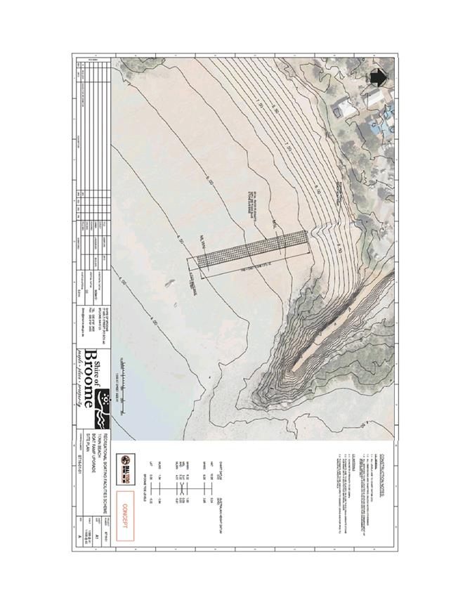
9.3
Our Prosperity
PRIORITY STATEMENT
Our
region has grown significantly over the past years in terms of population,
economy and industry – this will continue! Balancing ecological
sustainability with economic growth and retaining the ‘look and
feel’ of Broome and its environs are an ongoing challenge for the
region. Encouraging appropriate investment and business development
opportunities to ensure a strong, diverse economic base is essential for
community prosperity and the success of our future generations.
Focusing
on developing clear pathways linking education with employment for our youth
and the community at large is essential as we aim to retain our local people
and continue to build a skilled and highly motivated workforce.
Business
and Industry partnerships must be fostered to ensure sustainable economic
growth is achieved, along with the provision of affordable and equitable
services and infrastructure. Ensuring development meets community needs
and legislative requirements whilst creating close community relationships and
enhancing our understanding of local heritage and cultural issues will continue
to be a major focus. The built environment must contribute to the
economy, long term viability of the region and provide a quality lifestyle for
all.
|
9.3.1 REQUEST FOR BUDGET
AMENDMENT TO REFLECT CHINATOWN REVITALISATION INCOME AND EXPENDITURE FOR
FIRST QUARTER
LOCATION/ADDRESS: Nil
APPLICANT: Nil
FILE: PLA94
AUTHOR: Manager
Community Development
CONTRIBUTOR/S: Nil
RESPONSIBLE
OFFICER: Deputy
Chief Executive Officer/Director Community & Economic Development
DISCLOSURE
OF INTEREST: Nil
DATE OF REPORT: 8
July 2016
|
|
SUMMARY: Following
signing of the Financial Assistance Agreement for the Chinatown
Revitalisation Project, this report seeks Council’s adoption of a
budget amendment to reflect income and expenditure for this project in the
first quarter of the financial year.
|
BACKGROUND
Previous
Considerations
OMC 26 June 2014 Item
9.3.1
OMC 30 April 2015 Item
9.2.7
OMC 2 June 2015 Item
9.2.5
OMC 27 August 2015 Item
9.3.1
OMC 26 November 2015 Item
9.4.5
SMC 17 June 2016 Item
6.2.1
At the Special Council Meeting held
on 17 June 2016, Council resolved the following;
|
Council
Resolution:
(Report Recommendation)
Moved: Cr B
Rudeforth
Seconded: Cr H Tracey
That Council:
1. Thanks
the State of Western Australia for the $10 million grant funding for the
Chinatown Revitalisation Project.
2. Thanks
Tourism Western Australia for confirmation for the Tourism Demand Driver
Infrastructure Grant of $300,000 to be applied towards the Frederick
Street/Dampier Terrace Lookout Facility, which forms part of the Chinatown
Revitalisation Project.
3. Endorses
the Draft Financial Assistance Agreement with the Department of Regional
Development and authorises the Shire President and Chief Executive Officer to
engross the final documentation as required.
4. Endorses
the updated Memorandum of Understanding between the Shire of Broome, Landcorp
and Kimberley Development Commission and authorises the Shire President and
Chief Executive Officer to engross the documentation as required.
5. Endorses
the Chinatown Revitalisation Steering Group Terms of Reference and Governance
structure and appoints the Chief Executive Officer to be the Shire’s
representative on this group.
6. Requests
the Chief Executive Officer to:
(a) Allocate
$1.7 million dollars over the 2016/17 and 2017/18 financial years to the Chinatown
Revitalisation Project.
(b) Commence
procurement of the relevant consultancies together with the project
collaborative group in line with the project documentation.
(c) Ensure
incentives are included within project tender specifications to encourage
submissions from and/or involvement of local businesses where appropriate.
(d) Provide
six monthly updates on the project for Council’s information.
CARRIED UNANIMOUSLY 7/0
|
Following engrossing of the Financial
Assistance Agreement (FAA), an amount of $10 million was deposited into the
Shire’s account. These funds were then deposited to a Western Australian
Treasury Corporation Account until the amounts are expended following the
project milestone achievements set out in the agreement.
Given that confirmation of the
funding was received after the finalisation of the budget process, this project
was not included in the 2016/17 budget adopted by Council on 30 June
2016. This report seeks Council’s adoption of a budget amendment to
reflect the drawdown payments and expenditure to be incurred during the first
quarter of the 2016/17 financial year.
Further amendments will be requested
as part of the quarterly Financial and Costings Review process once detailed
plans and budgets are developed for each individual sub-project.
COMMENT
The FAA between the WA Department of
Regional Development (DRD) and the Shire of Broome provides an investment of
$10 million by the State for the delivery of the following projects.
|
Item of Expenditure
|
Budget
|
Source of Funds
|
|
Grey Street Extension
Feasibility & Technical Studies
|
$1,000,000
|
Royalties for Regions
($745,000)
Shire of Broome ($255,000)
|
|
Roebuck Bay Reconnection
and Coastal Protection Feasibility
|
$1,000,000
|
Royalties for Regions
($855,000)
Shire of Broome ($145,000)
|
|
Cultural Centre Feasibility
|
$750,000
|
Royalties for Regions
|
|
Dampier Terrace Renovation
|
$3,800,000
|
Royalties for Regions
|
|
Carnarvon Street Upgrades
|
$2,725,000
|
Royalties for Regions
|
|
Frederick Street Lookout
|
$900,000
|
Shire of Broome ($600,000)
Tourism WA ($300,000)
|
|
Tourist Rest Facilities
|
$700,000
|
Shire of Broome
|
|
Connection of Dampier
Terrace and Terrace Street
|
$600,000
|
Shire of Broome ($300,000)
Tourism WA ($300,000)
|
|
Enhanced laneways strategy
and funding program
|
$290,000
|
Royalties for Regions
|
|
Chinatown Commercial
Liaison Officer (over 2 years) and funding program
|
$600,000
|
Royalties for Regions
|
|
Administration/Audits/Reporting
|
$235,000
|
Royalties for Regions
|
|
Total Budget
|
$12,600,000
|
|
These projects have been scheduled
across two years and drawdowns of grant monies are scheduled in accordance with
agreed milestones. The first of these milestones is the signing and
return of the FAA which has triggered a milestone payment of $500,000.
The next milestone payment is due in December 2016 upon finalisation of project
plans for all ten sub-projects. This will provide the level of detail required
for a further budget amendment to recognise the income and expenditure for
these projects.
The first items of expenditure to be
incurred in 2016/17 in accordance with the adopted Business Case and the FAA
are the recruitment of a Chinatown Investment and Development Coordinator and
the engagement of a Project Director consultancy.
The recruitment of Chinatown
Investment and Development Coordinator will be undertaken by the Shire.
This role was endorsed pending grant funding as part of the organisational
structure during the adoption of the 2016/17 budget. The key
responsibilities of the role will be to;
· Develop
a two year business plan outlining a program of activities and events for the
activation of Chinatown.
· Maintain
effective and co-operative communications with traders, land owners and other
key stakeholders in Chinatown.
· Provide
a central point of communication for consultants engaged to undertake, manage
and/or facilitate sub-projects.
· Develop
strategies to encourage commercial tenant attraction and engagement, and
facilitate and realise investment in Chinatown.
· Project
manage/coordinate activation events, small capital projects and promotional
activities in Chinatown.
· Facilitate
an ongoing programme of events, place activation and branding for Chinatown.
The Project Director will be engaged by LandCorp in accordance with the
Procurement Plan for the Chinatown Revitalisation Project. LandCorp will engage one or two Project Management Consultancy firms
to lead a team of specialist consultants to deliver the feasibility studies
and/or design and construction projects detailed in the Chinatown
Revitalisation Business Case.
This
report seeks Council’s adoption of a budget amendment in order to
authorise expenditure related to these items during the first quarter of the
2016/17 financial year.
CONSULTATION
LandCorp
Kimberley Development Commission
Department of Regional Development
STATUTORY ENVIRONMENT
Local Government Act 1995
Part 6 — Financial
management
Division 4 — General
financial provisions
6.8. Expenditure
from municipal fund not included in annual budget
(1) A
local government is not to incur expenditure from its municipal fund for an
additional purpose except where the expenditure —
(a) is
incurred in a financial year before the adoption of the annual budget by the
local government; or
(b) is
authorised in advance by resolution*; or
(c) is
authorised in advance by the mayor or president in an emergency.
*
Absolute majority required.
(1a) In
subsection (1) —
additional
purpose means a purpose for which no expenditure estimate is included in
the local government’s annual budget.
POLICY IMPLICATIONS
Policy 2.1.1 Materiality
in Financial Reporting
FINANCIAL IMPLICATIONS
The table below outlines start up
costs and initial operational costs anticipated to be incurred during the first
quarter of the financial year. It also includes the first milestone
payment expected to be drawn down in accordance with the FAA.
|
Chinatown Revitalisation
|
Income
|
Expense
|
Remarks
|
Account Number
|
|
Salary
– Op Exp
|
|
$82,000
|
Chinatown
Investment & Development Coordinator
|
1367201
|
|
Other
employment costs
|
|
$2,400
|
Phone,
FBT, Workers Compensation
|
1367204
|
|
|
$7,750
|
Superannuation
|
1367202
|
|
Plant
operating costs
|
|
$4,000
|
Fuel,
servicing
|
1367215
|
|
Start-up
costs
|
|
$16,000
|
Vehicle
|
1367215
|
|
Operational
|
|
$387,850
|
Program
costs, Project Director fees etc.
|
1367211
|
|
Royalties
for Regions Grant
|
$500,000
|
|
First
milestone drawdown
|
1367301
(operating only)
|
|
TOTAL
|
$500,000
|
$500,000
|
|
|
RISK
As outlined in a
previous report to Council there are a number of risks associated with a
project of this size, particularly given the breath of obligations that have
been imposed on the Shire in respect of the grant funding. However, Officers
propose that strong community and stakeholder engagement and a robust
governance structure can be seen as effective mitigation of those risks.
This report is in
itself a risk mitigation strategy. Should officers be unable to progress
with the recruitment and engagement of the resources required, there is a risk
that the Shire will be unable to meet its obligations under the FAA.
STRATEGIC
IMPLICATIONS
Our People
Goal – Foster a community environment that is accessible, affordable,
inclusive, healthy and safe:
Effective communication
Our
Organisation Goal – Continually enhance the Shire’s organisational
capacity to service the needs of a growing community:
Sustainable and integrated strategic
and operational plans
Responsible resource allocation
Improved systems, processes and
compliance
VOTING REQUIREMENTS
Absolute Majority
|
REPORT
RECOMMENDATION:
That Council:
1. Notes
the milestone grant drawdown of $500,000 and the associated expenditure under
the Financial Assistance Agreement for the Chinatown Revitalisation Project
expected during the first quarter of the financial year.
2. Requests
the Chief Executive Officer to amend the 2016/17 Budget to reflect this
additional income and expenditure as follows:
|
Chinatown Revitalisation
|
Income
|
Expense
|
Account Number
|
|
Salary
– Op Exp
|
|
$82,000
|
1367201
|
|
Other
employment costs
|
|
$2,400
|
1367204
|
|
|
$7,750
|
1367202
|
|
Plant
operating costs
|
|
$4,000
|
1367215
|
|
Start-up
costs
|
|
$16,000
|
1367215
|
|
Operational
|
|
$387,850
|
1367211
|
|
Royalties
for Regions Grant
|
$500,000
|
|
1367301
(operating only)
|
|
TOTAL
|
$500,000
|
$500,000
|
|
3. Notes
that further budget amendments will be requested through the quarterly
Financial and Costing Review process to account for the additional income
expenditure related to this project once detailed project plans have been
developed.
(Absolute Majority Required)
|
Attachments
Nil
9.4
Our Organisation
PRIORITY STATEMENT
Council will strive to create an environment where
local governance is delivered in an open and accountable manner; where we
provide leadership to the region in such areas as planning and financial
management; where the community has the opportunity to contribute to the
Council’s decision making thereby fostering ownership of strategies and
initiatives.
In delivering open, accountable and inclusive governance,
we will be ever mindful that we operate within a highly regulated environment
that requires a high level of compliance.
Council will strive to be the conduit between the
other spheres of government and the community, translating State and Federal law,
policy and practice into customer focussed, on ground service delivery that
support’s Broome’s unique lifestyle.
The
Region is experiencing significant change with Council dedicated to sound
governance, effective leadership and innovation, and high quality
services. Building organisational capacity is a priority with a
commitment to delivering services to the community in a sustainable, effective
and accountable way.
|
9.4.1 MONTHLY PAYMENT LISTING -
JUNE 2016
LOCATION/ADDRESS: Nil
APPLICANT: Nil
FILE: FRE02
AUTHOR: Finance
Officer
CONTRIBUTOR/S: Nil
RESPONSIBLE
OFFICER: Acting
Director Corporate Services
DISCLOSURE
OF INTEREST: Nil
DATE OF REPORT: 14
July 2016
|
|
SUMMARY: This
report recommends that Council adopts the list of payments made under
delegated authority, as per the attachment to this report for the month of
June 2016.
|
BACKGROUND
Previous
Considerations
Nil
COMMENT
The Chief Executive Officer (CEO) has
delegated authority to make payments from the Municipal and Trust funds in
accordance with budget allocations.
The Shire provides payments to
suppliers by either Electronic Funds Transfer (EFT), cheque, credit card or
direct debit.
Attached is a list of all payments
processed under delegated authority during the month of June 2016.
CONSULTATION
Nil
STATUTORY ENVIRONMENT
Local Government (Financial Management) Regulations
1996
13. Lists of accounts
(1) If
the local government has delegated to the CEO the exercise of its power to make
payments from the municipal fund or the trust fund, a list of accounts paid by
the CEO is to be prepared each month showing for each account paid since the
last such list was prepared —
(a) the
payee’s name;
(b) the
amount of the payment;
(c) the
date of the payment; and
(d) sufficient
information to identify the transaction.
(3) A
list prepared under sub regulation (1) is to be —
(a) presented
to the council at the next ordinary meeting of the council after the list is
prepared; and
(b) recorded
in the minutes of that meeting.
POLICY IMPLICATIONS
Nil
FINANCIAL IMPLICATIONS
List of payments made in accordance
with budget and delegated authority.
RISK
The risk of Council not adopting this
report is extreme as this will result in non-compliance with Regulation 13 of
the Local Government (Financial Management) Regulations 1996. The likelihood of
this ever occurring is rare due to the CEO’s implementation of procedures
to ensure payment details are disclosed to Council in a timely manner, as well
as Procurement & Purchasing policies which ensure these payments are made
in accordance with budget and delegated authority and comply with Local
Government (Financial Management) Regulations 1996.
STRATEGIC
IMPLICATIONS
Our Organisation
Goal – Continually enhance the Shire’s organisational capacity to
service the needs of a growing community:
An organisational culture that
strives for service excellence
Responsible resource allocation
Effective community engagement
Improved systems, processes and
compliance
VOTING REQUIREMENTS
Simple Majority
|
REPORT
RECOMMENDATION:
That Council records the accounts as paid under
delegated authority for June 2016, totalling $5,967,073.90 as attached,
covering:
· EFT Vouchers
35861 – 36376 totalling $5,328,785.28;
· Municipal
Cheque Vouchers 57407– 57410 totalling $27,170.15;
· Trust Cheque
Vouchers 3415 totalling $12,650.34 and;
· Municipal
Direct Debits DD20369.5– DD20671.3 totalling $598,468.13.
|
Attachments
|
1.
|
Payment listing June
2016
|
|
Item 9.4.1 - MONTHLY PAYMENT LISTING - JUNE 2016
|
|
Part 5. Division 4. Section 5.42
Delegation of some powers to CEO. Sub Section Finance Management Regulation
12.
|
|
|
Each payment must show on a list the
payees name, the amount of the payment, the date of the payment and
sufficient
|
|
information to identify the
transaction
|
|
|
|
|
|
|
|
|
|
|
This report incorporates the
Delegation of Authority (Administration Regulation 19)
|
|
|
|
|
|
|
|
|
|
PAYMENTS BY EFT & CHEQUE AND
FROM TRUST - JUNE 2016
|
|
|
|
|
|
|
|
|
MUNICIPAL ELECTRONIC TRANSFER -
JUNE 2016
|
|
|
EFT
|
Date
|
Name
|
Description
|
Amount
|
Del Auth
|
|
EFT35861
|
02/06/2016
|
WESTERN AUSTRALIAN
TREASURY CORPORATION
|
Loan No. 194 Fixed
Component - BRAC Oval Pavilion
|
$63,442.38
|
MFS
|
|
EFT35862
|
02/06/2016
|
AVERY AIRCONDITIONING
PTY LTD
|
Air conditioning
maintenance- Various Shire sites
|
$15,288.91
|
MFS
|
|
EFT35863
|
02/06/2016
|
BARRELLS SURF N FITNESS
|
General operating
expenses - Swim Areas & Beach Lifeguard
|
$912.85
|
MFS
|
|
EFT35864
|
02/06/2016
|
BK SIGNS (HALLIDAY
ENTERPRISES PTY LTD)
|
Program annual events-
BRAC
|
$66.00
|
MFS
|
|
EFT35865
|
02/06/2016
|
BOC LIMITED
|
Dry ice pellet- Health
|
$6.38
|
MFS
|
|
EFT35866
|
02/06/2016
|
BP BROOME CENTRAL &
TYREPLUS BROOME
|
Fuel for small plant-
Depot
|
$314.27
|
MFS
|
|
EFT35867
|
02/06/2016
|
BROOME BETTA HOME LIVING
|
Building maintenance-
Shire Office Haas St
|
$149.00
|
MFS
|
|
EFT35868
|
02/06/2016
|
BROOME BOLT SUPPLIES WA
PTY LTD
|
Footpath maintenance-
Infrastructure
|
$1,628.00
|
MFS
|
|
EFT35869
|
02/06/2016
|
BROOME FREIGHTLINES (
CTI ONTRAQ )
|
Freight charges- Waste
Management Facility
|
$1,085.88
|
MFS
|
|
EFT35870
|
02/06/2016
|
BROOME SCOOTERS PTY LTD (KIMBERLEY
MOWERS & SPARES)
|
Town Beach water park
maintenance- P&G
|
$1,990.00
|
MFS
|
|
EFT35871
|
02/06/2016
|
BROOME TOYOTA
|
Vehicle service &
repair- CEO
|
$287.41
|
MFS
|
|
EFT35872
|
02/06/2016
|
BROOME TREE & PALM
SERVICE
|
Mulching (RFQ 16-15)-
Waste Management Facility
|
$43,076.00
|
MFS
|
|
EFT35873
|
02/06/2016
|
BROOME VISITOR CENTRE
|
Annual subsidy- Broome
Visitor Centre
|
$60,500.00
|
MFS
|
|
EFT35874
|
02/06/2016
|
CABLE BEACH ELECTRICAL
SERVICE
|
Electrical works-
Visitors Centre, Hammersley St & Shinju Fringe Festival
|
$407.00
|
MFS
|
|
EFT35875
|
02/06/2016
|
CABLE BEACH TYRE SERVICE
PTY LTD T/AS BRIDGESTONE BROOME
|
Various Vehicle
repair-Workshop
|
$1,574.94
|
MFS
|
|
EFT35876
|
02/06/2016
|
CARPET PAINT & TILE
CENTRE
|
Road formation-
Frederick Street & Dampier St Connection
|
$77.22
|
MFS
|
|
EFT35877
|
02/06/2016
|
CCI Learning Solutions
APPRENTICESHIPS AUSTRALIA
|
Organisational training-
HR
|
$4,958.57
|
MFS
|
|
EFT35878
|
02/06/2016
|
CLEVERPATCH
|
Assorted craft material-
Library
|
$369.93
|
MFS
|
|
EFT35879
|
02/06/2016
|
COASTAL DISTRIBUTING
& PROVEDORING ( CDP )
|
Stock for kiosk- BRAC
|
$392.48
|
MFS
|
|
EFT35880
|
02/06/2016
|
COATES HIRE OPERATIONS
PTY LTD
|
Equipment hire- P&G
|
$1,118.88
|
MFS
|
|
EFT35881
|
02/06/2016
|
CRUNCH CONSULTING PTY
LTD
|
Consultant fees- parking
and meals 04.04.16
|
$108.90
|
MFS
|
|
EFT35882
|
02/06/2016
|
DAVID JOHN DALY ROWBURY
|
Rates refund for
overpayment of rates assessment A120185
|
$1,288.93
|
MFS
|
|
EFT35883
|
02/06/2016
|
DEPARTMENT OF
AGRICULTURE & FOOD
|
Inspection of plant-
Nursery
|
$61.00
|
MFS
|
|
EFT35884
|
02/06/2016
|
DEPARTMENT OF FIRE &
EMERGENCY SERVICES (DFES)
|
2015/2016 ESL Contribution-
4th quarter
|
$86,780.28
|
MFS
|
|
EFT35885
|
02/06/2016
|
DORMA AUTOMATICS
PTY LTD
|
Building maintenance-
BRAC
|
$352.00
|
MFS
|
|
EFT35886
|
02/06/2016
|
EIGHTY MILE BEACH
CARAVAN PARK
|
Accommodation &
meals- Eighty Mile Beach Road
|
$2,376.00
|
MFS
|
|
EFT35887
|
02/06/2016
|
ENVIRONMENTAL HEALTH
AUSTRALIA INC
|
Subscription- Health
|
$550.00
|
MFS
|
|
EFT35888
|
02/06/2016
|
FITEVENTS (GLENN TAYLOR)
|
Promotions- Broome
Marathon
|
$11,000.00
|
MFS
|
|
EFT35889
|
02/06/2016
|
FOR EARTH PTY LTD
|
Liquid Waste- Waste
Management Facility
|
$9,042.00
|
MFS
|
|
EFT35890
|
02/06/2016
|
GISSA INTERNATIONAL PTY
LTD
|
License maintenance
& support- IT
|
$2,614.05
|
MFS
|
|
EFT35891
|
02/06/2016
|
GITTCRETE
|
Public utilities- Town
Beach Launching Ramp
|
$8,800.00
|
MFS
|
|
EFT35892
|
02/06/2016
|
GREENWAY ENTERPRISES
|
Consumables- Nursery
|
$1,997.17
|
MFS
|
|
EFT35893
|
02/06/2016
|
H & M TRACEY
CONSTRUCTION PTY LTD
|
Crossover Subsidy
-502/19 Hin Way
|
$515.00
|
MFS
|
|
EFT35894
|
02/06/2016
|
HAYS SPECIALIST
RECRUITMENT (AUSTRALIA) PTY LTD
|
Labour hire- Manager
Infrastructure Operations W/E 22.05.16
|
$3,916.55
|
MFS
|
|
EFT35895
|
02/06/2016
|
HIRE A HUBBY BROOME
|
Building & facility
maintenance- BRAC
|
$88.00
|
MFS
|
|
EFT35896
|
02/06/2016
|
HOLDFAST FLUID POWER NW
PTY LTD
|
Vehicle maintenance-
Workshop
|
$188.54
|
MFS
|
|
EFT35897
|
02/06/2016
|
HORIZON POWER
(ELECTRICITY USAGE)
|
Electricity charges-
Various Shire sites
|
$460.08
|
MFS
|
|
EFT35898
|
02/06/2016
|
HORIZON POWER (SERVICE
WORKS)
|
LED Streetlight upgrade-
Anne Street
|
$99,317.57
|
MFS
|
|
EFT35899
|
02/06/2016
|
HOTEL GRAND CHANCELLOR
ADELAIDE
|
Accommodation risk
management training- HR
|
$420.00
|
MFS
|
|
EFT35900
|
02/06/2016
|
HUTCHINSON REAL ESTATE
|
Staff rent
|
$1,740.00
|
MFS
|
|
EFT35901
|
02/06/2016
|
JASON SIGNMAKERS
|
Signage Maintenance-
Sector 6 Broome North / Blue Haze
|
$1,709.40
|
MFS
|
|
EFT35902
|
02/06/2016
|
JETRIDGE HOLDINGS PTY
LTD
|
Plumbing works- Roebuck
Bay Caravan Park
|
$1,430.00
|
MFS
|
|
EFT35903
|
02/06/2016
|
JULIE THOMAS
|
Rubbish bag collection-
P&G
|
$50.00
|
MFS
|
|
EFT35904
|
02/06/2016
|
KIMBERLEY BROOME PEST
CONTROL
|
Pest control- BRAC
|
$132.00
|
MFS
|
|
EFT35905
|
02/06/2016
|
KIMBERLEY FUEL & OIL
SERVICES
|
Oils & lubricants-
Workshop & Depot
|
$1,274.40
|
MFS
|
|
EFT35906
|
02/06/2016
|
KIMBERLEY GOLD PURE
DRINKING WATER
|
Drinking water- Waste
|
$152.00
|
MFS
|
|
EFT35907
|
02/06/2016
|
KIMBERLEY KERBS
|
Construction Contractor
(RFQ 15-39)- Frederick Street & Dampier St Connection
|
$17,825.78
|
MFS
|
|
EFT35908
|
02/06/2016
|
KIMBERLEY PLASTIC CUSTOM
FABRICATION
|
Tank repair- Haynes Oval
|
$533.50
|
MFS
|
|
EFT35909
|
02/06/2016
|
KIMBERLEY TRUSS
(NORTRUSS (NT) PTY LTD)
|
Tool replacement- Depot
|
$519.99
|
MFS
|
|
EFT35910
|
02/06/2016
|
KOMATSU AUSTRALIA PTY
LTD
|
Vehicle equipment-
Workshop
|
$113.12
|
MFS
|
|
EFT35911
|
02/06/2016
|
KOTT GUNNING LAWYERS
|
Legal fees- Polo on
Cable Beach
|
$1,002.21
|
MFS
|
|
EFT35912
|
02/06/2016
|
MAJOR MOTORS PTY LTD
|
Vehicle repairs-
Workshop
|
$921.84
|
MFS
|
|
EFT35913
|
02/06/2016
|
MARKETFORCE
|
Advertising & promotions-
Various Shire Departments
|
$2,545.28
|
MFS
|
|
EFT35914
|
02/06/2016
|
MCMULLEN NOLAN GROUP PTY
LTD (MNG)
|
Survey- Cable Beach
ramp, carpark Port Drive & Town Beach
|
$2,149.40
|
MFS
|
|
EFT35915
|
02/06/2016
|
METER OFFICE PRODUCTS
|
Program annual events-
BRAC
|
$103.40
|
MFS
|
|
EFT35916
|
02/06/2016
|
NATURAL PARENT MAGAZINE
|
Subscriptions magazine-
Library
|
$80.00
|
MFS
|
|
EFT35917
|
02/06/2016
|
NORTH WEST COAST
SECURITY
|
Security & other
operational expenses- Various Shire sites
|
$7,672.50
|
MFS
|
|
EFT35918
|
02/06/2016
|
NORTH WEST LOCKSMITHS
|
Security maintenance-
P&G
|
$4,050.00
|
MFS
|
|
EFT35919
|
02/06/2016
|
NORTHWEST HYDRO
SOLUTIONS (PATRICK ANNESLEY)
|
Maintenance- Waste
Management Facility
|
$88.00
|
MFS
|
|
EFT35920
|
02/06/2016
|
PERRY PAUNICH
MAINTENANCE CONTRACTORS ( PPMC )
|
Plumbing works- Male Oval
toilet
|
$165.00
|
MFS
|
|
EFT35921
|
02/06/2016
|
PERTH STITCHINGS
|
Staff uniform- Beach
Lifeguard
|
$838.20
|
MFS
|
|
EFT35922
|
02/06/2016
|
PINDAN LABOUR SOLUTIONS
PTY LTD (A DIVISION OF DFP RECRUITMENT)
|
Labour hire- Various
Shire positions
|
$3,988.34
|
MFS
|
|
EFT35923
|
02/06/2016
|
PRINTING IDEAS
|
Plant operation expenses
& staff printing- Workshop & HR
|
$2,461.80
|
MFS
|
|
EFT35924
|
02/06/2016
|
PRITCHARD FRANCIS PTY
LTD
|
Consultancy brief-
Hamersley Haas Roundabout
|
$357.50
|
MFS
|
|
EFT35925
|
02/06/2016
|
QUEST WEST PERTH
|
Accommodation organisational
training- Governance
|
$1,026.00
|
MFS
|
|
EFT35926
|
02/06/2016
|
ROEBUCK BAY HOTEL
|
Bar stock Melbourne
Comedy Festival- Civic Centre
|
$1,279.22
|
MFS
|
|
EFT35927
|
02/06/2016
|
ROEBUCK BAY WORKING
GROUP
|
Community sponsorship-
Community services
|
$1,100.00
|
MFS
|
|
EFT35928
|
02/06/2016
|
ROEBUCK TREE SERVICE
|
Arboriculture expenses-
Sector 3 Old Broome
|
$680.00
|
MFS
|
|
EFT35929
|
02/06/2016
|
ROEBUCK WELDING SERVICES
|
Vehicle maintenance-
Workshop
|
$1,155.00
|
MFS
|
|
EFT35930
|
02/06/2016
|
SARAH DOBSON
|
Reimbursement expenses -
Civic Centre
|
$233.09
|
MFS
|
|
EFT35931
|
02/06/2016
|
SEAMLESS CMS PTY LTD
|
License maintenance
& support - IT
|
$998.80
|
MFS
|
|
EFT35932
|
02/06/2016
|
SECUREX SECURITY PTY LTD
|
Security & other
operational expenses- Shire Office Haas St
|
$60.00
|
MFS
|
|
EFT35933
|
02/06/2016
|
TAMARA GRAFFEN
|
Reimbursement of
expenses- LGMA Challenge
|
$72.93
|
MFS
|
|
EFT35934
|
02/06/2016
|
TECHWEST SOLUTIONS
|
Sporting equipment- BRAC
|
$66.11
|
MFS
|
|
EFT35935
|
02/06/2016
|
TELSTRA
|
Phone charges- Various
Shire phones
|
$9,997.03
|
MFS
|
|
EFT35936
|
02/06/2016
|
TERRITORY RURAL BROOME
|
Maintenance- P&G
|
$2,220.37
|
MFS
|
|
EFT35937
|
02/06/2016
|
THE MANGROVE RESORT
HOTEL (GARRETT HOSPITALITY PTY LTD)
|
Accommodation training
consultants - HR
|
$666.00
|
MFS
|
|
EFT35938
|
02/06/2016
|
THE WORKWEAR GROUP
(NNT)
|
Staff uniform
|
$501.68
|
MFS
|
|
EFT35939
|
02/06/2016
|
TOLL IPEC PTY LTD
|
Freight charges- P&G
|
$149.60
|
MFS
|
|
EFT35940
|
02/06/2016
|
TOTAL EDEN PTY LTD
|
Reticulation parts,
materials & consumables- P&G
|
$4,516.84
|
MFS
|
|
EFT35941
|
02/06/2016
|
TOTALLY WORKWEAR
|
Promotional programmes
& materials- Library
|
$14.00
|
MFS
|
|
EFT35942
|
02/06/2016
|
WESTERN AUSTRALIAN LOCAL
GOVERNMENT ASSOCIATION (WALGA)
|
Procurement services
& organisational training - Cable Beach Lifeguard Services & HR
|
$12,856.53
|
MFS
|
|
EFT35943
|
02/06/2016
|
WILD MANGO CAFE
|
Catering for OMC 26 May
& Minister for Indigenous Affairs dinner- Governance
|
$735.50
|
MFS
|
|
EFT35944
|
02/06/2016
|
ANDRE STEFANUS
SCHONFELDT
|
Bond refund - Staff
Housing
|
$1,880.68
|
MFS
|
|
EFT35945
|
02/06/2016
|
IP & ST ELSON PTY
LTD
|
Trust refund for
planning application fee- Planning Services
|
$39.50
|
MFS
|
|
EFT35946
|
02/06/2016
|
STELLA JACKAMARRA
|
Bond refund- Events
|
$1,000.00
|
MFS
|
|
EFT35947
|
02/06/2016
|
WILD WEST ENTERTAINMENT
|
Bond refund- Events
|
$1,000.00
|
MFS
|
|
EFT35948
|
08/06/2016
|
IGA - SEAVIEW (BROOME
INVESTMENT GROUP PTY LTD T/AS)
|
Daily & weekly
newspapers- Library
|
$107.60
|
MFS
|
|
EFT35949
|
09/06/2016
|
VIVA ENERGY AUSTRALIA
|
Fuel card purchases-
Various Shire vehicles
|
$177.78
|
MFS
|
|
EFT35950
|
09/06/2016
|
SALARY & WAGES
|
Payroll S & W
|
$650.00
|
MFS
|
|
EFT35951
|
09/06/2016
|
SALARY & WAGES
|
Payroll S & W
|
$488.45
|
MFS
|
|
EFT35952
|
09/06/2016
|
AUSTRALIAN TAXATION
OFFICE
|
PAYG
|
$108,276.77
|
MFS
|
|
EFT35953
|
09/06/2016
|
SALARY & WAGES
|
Payroll S & W
|
$750.00
|
MFS
|
|
EFT35954
|
09/06/2016
|
SALARY & WAGES
|
Payroll S & W
|
$630.34
|
MFS
|
|
EFT35955
|
09/06/2016
|
SALARY & WAGES
|
Payroll S & W
|
$600.00
|
MFS
|
|
EFT35956
|
09/06/2016
|
SALARY & WAGES
|
Payroll S & W
|
$420.00
|
MFS
|
|
EFT35957
|
09/06/2016
|
SALARY & WAGES
|
Payroll S & W
|
$552.16
|
MFS
|
|
EFT35958
|
09/06/2016
|
SALARY & WAGES
|
Payroll S & W
|
$410.00
|
MFS
|
|
EFT35959
|
09/06/2016
|
SALARY & WAGES
|
Payroll S & W
|
$450.00
|
MFS
|
|
EFT35960
|
09/06/2016
|
SALARY & WAGES
|
Payroll S & W
|
$330.00
|
MFS
|
|
EFT35961
|
09/06/2016
|
SALARY & WAGES
|
Payroll S & W
|
$1,608.61
|
MFS
|
|
EFT35962
|
09/06/2016
|
SALARY & WAGES
|
Payroll S & W
|
$430.11
|
MFS
|
|
EFT35963
|
09/06/2016
|
SALARY & WAGES
|
Payroll S & W
|
$340.00
|
MFS
|
|
EFT35964
|
09/06/2016
|
SALARY & WAGES
|
Payroll S & W
|
$1,515.11
|
MFS
|
|
EFT35965
|
09/06/2016
|
SALARY & WAGES
|
Payroll S & W
|
$201.10
|
MFS
|
|
EFT35966
|
09/06/2016
|
SALARY & WAGES
|
Payroll S & W
|
$88.17
|
MFS
|
|
EFT35967
|
09/06/2016
|
SALARY & WAGES
|
Payroll S & W
|
$300.00
|
MFS
|
|
EFT35968
|
09/06/2016
|
SALARY & WAGES
|
Payroll S & W
|
$457.57
|
MFS
|
|
EFT35969
|
09/06/2016
|
SALARY & WAGES
|
Payroll S & W
|
$353.22
|
MFS
|
|
EFT35970
|
09/06/2016
|
SALARY & WAGES
|
Payroll S & W
|
$1,028.09
|
MFS
|
|
EFT35971
|
09/06/2016
|
SALARY & WAGES
|
Payroll S & W
|
$614.52
|
MFS
|
|
EFT35972
|
09/06/2016
|
AUSTRALIAN SERVICES
UNION - WA BRANCH
|
Payroll deductions
|
$1,106.20
|
MFS
|
|
EFT35973
|
09/06/2016
|
BROOME SHIRE INSIDE
STAFF SOCIAL CLUB
|
Payroll deductions
|
$780.00
|
MFS
|
|
EFT35974
|
09/06/2016
|
BROOME SHIRE OUTDOOR
STAFF SOCIAL CLUB
|
Payroll deductions
|
$740.00
|
MFS
|
|
EFT35975
|
09/06/2016
|
CHILD SUPPORT AGENCY
|
Payroll deductions
|
$1,122.98
|
MFS
|
|
EFT35976
|
09/06/2016
|
LGRCEU
|
Payroll deductions
|
$19.40
|
MFS
|
|
EFT35977
|
09/06/2016
|
BROOME COMMONWEALTH
TRADING BANK
|
Salary and wages pay
period ending: 07/06/16
|
$311,580.38
|
MFS
|
|
EFT35978
|
10/06/2016
|
PEARL COAST PROPERTIES
PTY LTD
|
Contribution 50% of
stage 1B costs- Frederick Street Main Drain Project Agreed
|
$789,016.60
|
MFS
|
|
EFT35979
|
13/06/2016
|
BROOME CHAMBER OF
COMMERCE
|
Small Business Awards
2016- Sponsorship
|
$7,700.00
|
MFS
|
|
EFT35980
|
13/06/2016
|
DINOSAUR COAST
MANAGEMENT GROUP
|
Community sponsorship
program- Community Services
|
$3,000.00
|
MFS
|
|
EFT35981
|
13/06/2016
|
MEN'S SHED BROOME
|
Community sponsorship
program- Community Services
|
$2,400.00
|
MFS
|
|
EFT35982
|
13/06/2016
|
REGIONAL DEVELOPMENT
AUSTRALIA KIMBERLEY
|
Community sponsorship
program- Community Services
|
$10,000.00
|
MFS
|
|
EFT35983
|
13/06/2016
|
SALTWATER COUNTRY Inc.
|
Community sponsorship
program- Community Services
|
$5,000.00
|
MFS
|
|
EFT35984
|
13/06/2016
|
TIMOTHY JOSEPH GRAFFEN
|
Reimbursement expenses-
LGMA challenge
|
$39.00
|
MFS
|
|
EFT35985
|
13/06/2016
|
UNIVERSITY OF NOTRE DAME
AUSTRALIA
|
Community sponsorship
program- Community Services
|
$4,620.00
|
MFS
|
|
EFT35986
|
13/06/2016
|
YANGET NOMINEES PTY LTD
|
Rates refund for
overpayment assessment A304911
|
$445.06
|
MFS
|
|
EFT35987
|
13/06/2016
|
AD ENGINEERING
INTERNATIONAL PTY LTD
|
Utility charges- Cape
Leveque Road
|
$132.00
|
MFS
|
|
EFT35988
|
13/06/2016
|
AECOM- URS AUSTRALIA PTY
LTD
|
Consultant fees- Site
investigation of Broome golf course
|
$4,449.50
|
MFS
|
|
EFT35989
|
13/06/2016
|
AMO CONTRACTING
|
Footpath maintenance-
Sector 5 Roebuck Estate
|
$3,500.20
|
MFS
|
|
EFT35990
|
13/06/2016
|
AMPAC DEBT RECOVERY
|
Debt recovery costs-
Rates
|
$1.44
|
MFS
|
|
EFT35991
|
13/06/2016
|
AVERY AIRCONDITIONING
PTY LTD
|
Air conditioning works-
Various Shire sites
|
$2,532.48
|
MFS
|
|
EFT35992
|
13/06/2016
|
BAIRD AUSTRALIA PTY LTD
|
Community engagement
strategy consultant fee (RFQ15-30)- Broome CHRMAP
|
$9,570.00
|
MFS
|
|
EFT35993
|
13/06/2016
|
BITUMEN SEALING SERVICES
PTY LTD (BSS)
|
Road maintenance (RFT
15-07)- Roebuck Bay caravan park
|
$51,070.78
|
MFS
|
|
EFT35994
|
13/06/2016
|
BP AUSTRALIA PTY LTD -
FUEL
|
Diesel for Shire fleet-
Depot
|
$15,595.70
|
MFS
|
|
EFT35995
|
13/06/2016
|
BRIDGESTONE AUSTRALIA
LTD
|
Vehicle repair- Workshop
|
$1,118.64
|
MFS
|
|
EFT35996
|
13/06/2016
|
BROOME BETTA HOME LIVING
|
Property maintenance- Key worker housing
|
$30.00
|
MFS
|
|
EFT35997
|
13/06/2016
|
BROOME BOLT SUPPLIES WA
PTY LTD
|
Consumables &
material- Various Shire Departments
|
$283.25
|
MFS
|
|
EFT35998
|
13/06/2016
|
BROOME DIESEL & HYDRAULIC
SERVICE
|
Repairs to machinery-
Workshop
|
$7,423.30
|
MFS
|
|
EFT35999
|
13/06/2016
|
BROOME ENGRAVING &
MULTI SERVICES
|
Engraving for Broome
Diocese civic reception gift- Governance
|
$35.00
|
MFS
|
|
EFT36000
|
13/06/2016
|
BROOME MOTORS
|
Vehicle repairs & maintenance-
Workshop
|
$2,098.05
|
MFS
|
|
EFT36001
|
13/06/2016
|
BROOME PLUMBING &
GAS
|
Plumbing works- Various
Shire sites
|
$2,641.00
|
MFS
|
|
EFT36002
|
13/06/2016
|
BROOME PROGRESSIVE
SUPPLIES
|
Stock kiosk & other
materials- Various Shire Departments
|
$1,367.21
|
MFS
|
|
EFT36003
|
13/06/2016
|
BROOME RETRAVISION
|
Sundry equipment &
minor asset purchase- BRAC & Depot
|
$466.00
|
MFS
|
|
EFT36004
|
13/06/2016
|
BROOME SMALL MAINTENANCE
SERVICES
|
Building general
maintenance- Civic Centre & BRAC
|
$529.00
|
MFS
|
|
EFT36005
|
13/06/2016
|
BROOMECRETE
|
Concrete & other
materials- Various reserves & parks
|
$3,031.60
|
MFS
|
|
EFT36006
|
13/06/2016
|
BT EQUIPMENT PTY LTD
|
Vehicle parts- Workshop
|
$802.63
|
MFS
|
|
EFT36007
|
13/06/2016
|
J BLACKWOOD & SON
T/AS BLACKWOODS
|
Tool replacement &
Consumables- Depot & Civic Centre
|
$2,847.68
|
MFS
|
|
EFT36008
|
13/06/2016
|
KADAR PEARSON PARTNERS
PTY LTD
|
Consultant expenses-
Short Term Itinerant Camping Facility
|
$20,160.00
|
MFS
|
|
EFT36009
|
13/06/2016
|
KIMBERLEY CAMPING &
OUTBACK SUPPLIES
|
Staff uniform
|
$891.81
|
MFS
|
|
EFT36010
|
13/06/2016
|
KIMBERLEY FUEL & OIL
SERVICES
|
Plant fuel & oil-
Workshop
|
$5,977.54
|
MFS
|
|
EFT36011
|
13/06/2016
|
KIMBERLEY GOLD PURE
DRINKING WATER
|
Drinking water-
Infrastructure & Administration Building
|
$247.00
|
MFS
|
|
EFT36012
|
13/06/2016
|
KIMBERLEY WINDOWS
DESIGNER BLINDS
|
Replacement blinds- BRAC
|
$403.70
|
MFS
|
|
EFT36013
|
13/06/2016
|
KOTT GUNNING LAWYERS
|
Legal expenses- Building
order & Native Title Act
|
$5,186.42
|
MFS
|
|
EFT36014
|
13/06/2016
|
WESTERN AUSTRALIAN LOCAL
GOVERNMENT ASSOCIATION (WALGA)
|
Tender process
management- Shire directory production expenses
|
$7,462.13
|
MFS
|
|
EFT36015
|
13/06/2016
|
WILD MANGO CAFE
|
Catering for Broome
Diocese Golden Jubilee Civic Reception & training- Governance & HR
|
$706.00
|
MFS
|
|
EFT36017
|
14/06/2016
|
WA HINO
|
Replacement plant (RFQ
15-38)- Depot
|
$116,775.61
|
MFS
|
|
EFT36018
|
15/06/2016
|
ACROMAT
|
Tools & equipment-
BRAC
|
$125.40
|
MFS
|
|
EFT36019
|
15/06/2016
|
BRIDGESTONE AUSTRALIA
LTD
|
Tyre repair- Waste
Management Facility Team
|
$265.96
|
MFS
|
|
EFT36020
|
15/06/2016
|
BROOM TIME CLEANING
|
Cleaning services-
Various Shire sites
|
$50,550.66
|
MFS
|
|
EFT36021
|
15/06/2016
|
BROOME BUILDERS PTY LTD
|
Construction expenses-
Key Worker Housing & Roebuck Bay Caravan Park building renewal as per
lease
|
$136,492.00
|
MFS
|
|
EFT36022
|
15/06/2016
|
BROOME CLARK RUBBER
|
Aquatic chemical-Various
Shire sites
|
$4,015.69
|
MFS
|
|
EFT36023
|
15/06/2016
|
BROOME DIESEL &
HYDRAULIC SERVICE
|
Vehicle repairs-
Workshop
|
$112.50
|
MFS
|
|
EFT36024
|
15/06/2016
|
BROOME MOTORS
|
Vehicle repairs-
Workshop
|
$381.70
|
MFS
|
|
EFT36025
|
15/06/2016
|
BROOME PLUMBING &
GAS
|
Plumbing works- Various
Shire sites
|
$1,674.00
|
MFS
|
|
EFT36026
|
15/06/2016
|
BROOME SMALL MAINTENANCE
SERVICES
|
Building maintenance- HR
|
$187.00
|
MFS
|
|
EFT36027
|
15/06/2016
|
CABLE BEACH ELECTRICAL
SERVICE
|
Oval lighting- Male Oval
|
$3,245.00
|
MFS
|
|
EFT36028
|
15/06/2016
|
CABLE BEACH TYRE SERVICE
PTY LTD T/AS BRIDGESTONE BROOME
|
Vehicle repairs-
Workshop
|
$1,435.00
|
MFS
|
|
EFT36029
|
15/06/2016
|
CARDNO (WA) PTY LTD
|
District stormwater
management strategy (RFQ16-16)- Stormwater Drainage
|
$4,651.57
|
MFS
|
|
EFT36030
|
15/06/2016
|
CARPET PAINT & TILE
CENTRE
|
Material purchase- KRO2
& Town Beach Water Park
|
$11,281.38
|
MFS
|
|
EFT36031
|
15/06/2016
|
CENTURION TRANSPORT
|
Freight charges- Library
|
$118.65
|
MFS
|
|
EFT36032
|
15/06/2016
|
COATES HIRE OPERATIONS
PTY LTD
|
Hire of equipment- Male
Oval & Frederick Street & Dampier Street connection
|
$618.84
|
MFS
|
|
EFT36033
|
15/06/2016
|
J BLACKWOOD & SON
T/AS BLACKWOODS
|
Maintenance supplies-
BRAC
|
$81.95
|
MFS
|
|
EFT36034
|
15/06/2016
|
BROOME TOYOTA
|
Reversing camera repair-
CEO vehicle
|
$8.86
|
MFS
|
|
EFT36035
|
15/06/2016
|
DATACOM
|
Equipment supplies- IT
|
$543.40
|
MFS
|
|
EFT36036
|
15/06/2016
|
DAVID GRAY & CO PTY
LTD
|
Bin security locks-
P&G
|
$1,958.00
|
MFS
|
|
EFT36037
|
15/06/2016
|
DEANO'S CANVAS WORKS
|
Shade sails repair-
Various shire sites
|
$3,382.50
|
MFS
|
|
EFT36038
|
15/06/2016
|
DIRECTCOMMS PTY LTD
|
SMS service for overdue
& reserved books- Library
|
$144.84
|
MFS
|
|
EFT36039
|
15/06/2016
|
DONOVAN PAYNE ARCHITECTS
PTY LTD
|
Architectural services
& concept design (RFQ 15-50)- KRO2
|
$70,455.00
|
MFS
|
|
EFT36040
|
15/06/2016
|
EDUCATIONAL EXPERIENCE
|
Multifunction craft
trolley- BRAC
|
$383.79
|
MFS
|
|
EFT36041
|
15/06/2016
|
FIELD AIR CONDITIONING
& AUTO ELECTRICAL PTY LTD
|
Vehicle repair- Workshop
|
$6,448.20
|
MFS
|
|
EFT36042
|
15/06/2016
|
FIRE & SAFETY
SERVICES
|
Building maintenance-
Civic Centre
|
$838.56
|
MFS
|
|
EFT36043
|
15/06/2016
|
FIRE PROTECTION
ASSOCIATION AUSTRALIA
|
Training building &
planning in bushfire prone areas - HR
|
$190.00
|
MFS
|
|
EFT36044
|
15/06/2016
|
GINA NICOLE HAILES
|
Group fitness program-
BRAC
|
$1,800.00
|
MFS
|
|
EFT36045
|
15/06/2016
|
MARKETFORCE
|
Recruitment & tender
advertising- Various Shire departments
|
$805.47
|
MFS
|
|
EFT36046
|
15/06/2016
|
MCKENO BLOCKS &
PAVERS
|
Road formation-
Frederick St & Dampier St connection
|
$770.81
|
MFS
|
|
EFT36047
|
15/06/2016
|
MELBOURNE INTERNATIONAL
COMEDY FESTIVAL
|
Performance production
expenses Melbourne Comedy Festival- Civic Centre
|
$2,683.70
|
MFS
|
|
EFT36048
|
15/06/2016
|
MERCURE HOTEL PERTH
|
Accommodation for CEO to
attend WARCA meeting & Building Technical Officer to attend
training in Perth
|
$1,065.00
|
MFS
|
|
EFT36049
|
15/06/2016
|
MIDALIA STEEL PTY LTD
|
Drainage material &
footpath maintenance- Maritana Park & Works
|
$913.83
|
MFS
|
|
EFT36050
|
15/06/2016
|
NDY MANAGEMENT PTY LTD
|
Plant & equipment
renewal (RFQ 15-55)- BRAC Aquatic Upgrade
|
$7,330.40
|
MFS
|
|
EFT36051
|
15/06/2016
|
NORTH WEST COAST
SECURITY
|
Security & other
operational expenses- Civic Centre & various Shire Sites
|
$10,030.46
|
MFS
|
|
EFT36052
|
15/06/2016
|
NS PROJECTS PTY LTD
|
Design & development
phase- BRAC Aquatic Upgrade & KRO3
|
$13,428.90
|
MFS
|
|
EFT36053
|
15/06/2016
|
SECUREPAY PTY LTD
|
Web payments & Seat Advisor
pricing transaction fee for ticketing- Civic Centre
|
$54.12
|
MFS
|
|
EFT36054
|
15/06/2016
|
SPORTS STAR TROPHIES
|
Trophies BRAC 2 Beach
Fun run- BRAC
|
$1,015.20
|
MFS
|
|
EFT36055
|
15/06/2016
|
ST JOHN AMBULANCE
AUSTRALIA - BROOME
|
First Aid Kit- BRAC
|
$200.00
|
MFS
|
|
EFT36056
|
15/06/2016
|
T - QUIP
|
Vehicle repairs-
Workshop & Depot
|
$1,580.40
|
MFS
|
|
EFT36057
|
15/06/2016
|
TALIS CONSULTANTS
|
Consultant fees-
Infrastructure
|
$1,870.00
|
MFS
|
|
EFT36058
|
15/06/2016
|
TELSTRA
|
Phone charges- Various
Shire phones
|
$283.98
|
MFS
|
|
EFT36059
|
15/06/2016
|
THE MANGROVE RESORT
HOTEL (GARRETT HOSPITALITY PTY LTD)
|
Bar tab to be recouped
from Shire of East Pilbara- Health
|
$460.00
|
MFS
|
|
EFT36060
|
15/06/2016
|
THEATRE KIMBERLEY INC
|
Performance production
expenses- Civic Centre
|
$3,740.00
|
MFS
|
|
EFT36061
|
15/06/2016
|
TNT AUSTRALIA PTY LTD
T/AS TNT EXPRESS
|
Freight charges- Health
& Depot
|
$199.52
|
MFS
|
|
EFT36062
|
15/06/2016
|
TOTAL EDEN PTY LTD
|
Reticulation parts,
materials & consumables- P&G
|
$378.77
|
MFS
|
|
EFT36063
|
15/06/2016
|
TOTALLY WORKWEAR
|
Staff uniform
|
$242.80
|
MFS
|
|
EFT36064
|
15/06/2016
|
TOXFREE
|
Waste services- Various
Shire sites
|
$5,608.64
|
MFS
|
|
EFT36065
|
21/06/2016
|
WATER CORPORATION
|
Water charges- Various
Shire sites
|
$49,317.08
|
MFS
|
|
EFT36066
|
21/06/2016
|
KIMBERLEY ABORIGINAL
MEDICAL SERVICES LTD
|
Rates refund for
assessment A107860 as per Council resolution SMC 10 June 2016
|
$110,377.80
|
MFS
|
|
EFT36067
|
22/06/2016
|
AUSTRALIA POST
|
Postage Charges.
Period ending 31.05.16
|
$2,414.90
|
MFS
|
|
EFT36068
|
22/06/2016
|
BEST KIMBERLEY COMPUTING
|
Purchase of new colour photocopier
(RFQ16-08)- IT
|
$19,385.30
|
MFS
|
|
EFT36069
|
22/06/2016
|
BROOM TIME CLEANING
|
Cleaning services (RFQ
12-09)- Administration Offices & Library
|
$9,360.00
|
MFS
|
|
EFT36070
|
22/06/2016
|
BROOME PHARMACY
|
Safety equipment &
first aid supplies- BRAC & Depot
|
$208.30
|
MFS
|
|
EFT36071
|
22/06/2016
|
BROOME VETERINARY
HOSPITAL
|
Pound, euthanasia &
boarding fees May- Rangers
|
$4,565.38
|
MFS
|
|
EFT36072
|
22/06/2016
|
COLES SUPERMARKETS -
CHINATOWN, S324
|
Food & beverages-
Monthly fee Various meetings & Training
|
$434.22
|
MFS
|
|
EFT36073
|
22/06/2016
|
COLIN WILKINSON
DEVELOPMENTS PTY LTD
|
Crossover Subsidy- Lot
705/25 Orr Street
|
$515.00
|
MFS
|
|
EFT36074
|
22/06/2016
|
DEPARTMENT OF TRANSPORT
(VEHICLE SEARCH FEES)
|
Fines enforcement
registry expenses- Rangers
|
$93.80
|
MFS
|
|
EFT36075
|
22/06/2016
|
FLEET LOGISTICS PTY LTD
(EZY2C)
|
GPS tracking (RFQ
16-28)- IT
|
$19,030.66
|
MFS
|
|
EFT36076
|
22/06/2016
|
H & M TRACEY
CONSTRUCTION PTY LTD
|
Crossover Subsidy- Lot
222/ 52 Robinson St
|
$515.00
|
MFS
|
|
EFT36077
|
22/06/2016
|
HAYS SPECIALIST
RECRUITMENT (AUSTRALIA) PTY LTD
|
Labour hire Manager
Infrastructure Operations- Infrastructure
|
$3,916.55
|
MFS
|
|
EFT36078
|
22/06/2016
|
HILTI AUST PTY LTD
|
Material purchase-
Japanese Cemetery
|
$2,236.39
|
MFS
|
|
EFT36079
|
22/06/2016
|
HORIZON POWER
(ELECTRICITY USAGE)
|
Electricity charges-
Various Shire sites
|
$102,526.95
|
MFS
|
|
EFT36080
|
22/06/2016
|
INVARION RAPIDPLAN PTY
LTD
|
License maintenance
& support- IT
|
$1,650.00
|
MFS
|
|
EFT36081
|
22/06/2016
|
JULIE THOMAS
|
Town rubbish bag
collection- P&G
|
$20.00
|
MFS
|
|
EFT36082
|
22/06/2016
|
KIMBERLEY QUARRY PTY LTD
|
Road base material (RFQ
13-07)- Hamersley & Haas St
|
$19,495.69
|
MFS
|
|
EFT36083
|
22/06/2016
|
LOCAL DRUG ACTION GROUPS
INC
|
Alcohol signage &
toolkit- Economic Services
|
$7,000.00
|
MFS
|
|
EFT36084
|
22/06/2016
|
RAY WHITE BROOME
|
Staff Rent
|
$8,445.52
|
MFS
|
|
EFT36085
|
22/06/2016
|
ROADLINE CIVIL
CONTRACTORS
|
Construction contractor-
Various Shire sites
|
$348,147.63
|
MFS
|
|
EFT36086
|
22/06/2016
|
ROEBUCK WELDING SERVICES
|
Stainless poles- Town
Beach
|
$1,548.80
|
MFS
|
|
EFT36087
|
22/06/2016
|
TELSTRA
|
Phone charges- Various
Shire phones
|
$726.82
|
MFS
|
|
EFT36088
|
22/06/2016
|
TOTAL EDEN PTY LTD
|
Reticulation parts,
materials & consumable- P&G
|
$1,761.67
|
MFS
|
|
EFT36089
|
22/06/2016
|
TOXFREE
|
Waste services- Various
Shire sites
|
$97,590.94
|
MFS
|
|
EFT36090
|
22/06/2016
|
ULTRAHAWKE PTY LTD
|
Tip improvements- Waste
Management Facility
|
$44,614.35
|
MFS
|
|
EFT36091
|
23/06/2016
|
BROOME FIRST NATIONAL
REAL ESTATE
|
Staff Rent
|
$10,352.37
|
MFS
|
|
EFT36092
|
23/06/2016
|
CHARTER PROPERTY GROUP
PTY LTD
|
staff rent
|
$2,607.14
|
MFS
|
|
EFT36093
|
23/06/2016
|
HUTCHINSON REAL ESTATE
|
Staff Rent
|
$3,845.52
|
MFS
|
|
EFT36094
|
23/06/2016
|
MAX BERNARD GRAFFEN
|
Staff Rent
|
$2,166.67
|
MFS
|
|
EFT36095
|
23/06/2016
|
PRD NATIONWIDE
|
Community Storage rent
|
$2,475.00
|
MFS
|
|
EFT36096
|
23/06/2016
|
RAY WHITE BROOME
|
Staff Rent
|
$12,866.42
|
MFS
|
|
EFT36097
|
23/06/2016
|
SALARY & WAGES
|
Payroll S & W
|
$650.00
|
MFS
|
|
EFT36098
|
23/06/2016
|
SALARY & WAGES
|
Payroll S & W
|
$488.45
|
MFS
|
|
EFT36099
|
23/06/2016
|
AUSTRALIAN TAXATION
OFFICE
|
PAYG
|
$113,622.74
|
MFS
|
|
EFT36100
|
23/06/2016
|
SALARY & WAGES
|
Payroll S & W
|
$750.00
|
MFS
|
|
EFT36101
|
23/06/2016
|
SALARY & WAGES
|
Payroll S & W
|
$630.27
|
MFS
|
|
EFT36102
|
23/06/2016
|
SALARY & WAGES
|
Payroll S & W
|
$600.00
|
MFS
|
|
EFT36103
|
23/06/2016
|
SALARY & WAGES
|
Payroll S & W
|
$0.03
|
MFS
|
|
EFT36104
|
23/06/2016
|
SALARY & WAGES
|
Payroll S & W
|
$420.00
|
MFS
|
|
EFT36105
|
23/06/2016
|
SALARY & WAGES
|
Payroll S & W
|
$552.16
|
MFS
|
|
EFT36106
|
23/06/2016
|
SALARY & WAGES
|
Payroll S & W
|
$410.00
|
MFS
|
|
EFT36107
|
23/06/2016
|
SALARY & WAGES
|
Payroll S & W
|
$450.00
|
MFS
|
|
EFT36108
|
23/06/2016
|
SALARY & WAGES
|
Payroll S & W
|
$330.00
|
MFS
|
|
EFT36109
|
23/06/2016
|
SALARY & WAGES
|
Payroll S & W
|
$1,608.61
|
MFS
|
|
EFT36110
|
23/06/2016
|
SALARY & WAGES
|
Payroll S & W
|
$250.00
|
MFS
|
|
EFT36111
|
23/06/2016
|
SALARY & WAGES
|
Payroll S & W
|
$430.11
|
MFS
|
|
EFT36112
|
23/06/2016
|
SALARY & WAGES
|
Payroll S & W
|
$340.00
|
MFS
|
|
EFT36113
|
23/06/2016
|
SALARY & WAGES
|
Payroll S & W
|
$800.00
|
MFS
|
|
EFT36114
|
23/06/2016
|
SALARY & WAGES
|
Payroll S & W
|
$520.27
|
MFS
|
|
EFT36115
|
23/06/2016
|
SALARY & WAGES
|
Payroll S & W
|
$201.10
|
MFS
|
|
EFT36116
|
23/06/2016
|
SALARY & WAGES
|
Payroll S & W
|
$88.17
|
MFS
|
|
EFT36117
|
23/06/2016
|
SALARY & WAGES
|
Payroll S & W
|
$300.00
|
MFS
|
|
EFT36118
|
23/06/2016
|
SALARY & WAGES
|
Payroll S & W
|
$457.57
|
MFS
|
|
EFT36119
|
23/06/2016
|
SALARY & WAGES
|
Payroll S & W
|
$353.22
|
MFS
|
|
EFT36120
|
23/06/2016
|
SALARY & WAGES
|
Payroll S & W
|
$1,028.09
|
MFS
|
|
EFT36121
|
23/06/2016
|
AUSTRALIAN SERVICES
UNION - WA BRANCH
|
Payroll deductions
|
$1,132.00
|
MFS
|
|
EFT36122
|
23/06/2016
|
BROOME SHIRE INSIDE
STAFF SOCIAL CLUB
|
Payroll deductions
|
$860.00
|
MFS
|
|
EFT36123
|
23/06/2016
|
BROOME SHIRE OUTDOOR
STAFF SOCIAL CLUB
|
Payroll deductions
|
$680.00
|
MFS
|
|
EFT36124
|
23/06/2016
|
CHILD SUPPORT AGENCY
|
Payroll deductions
|
$1,122.98
|
MFS
|
|
EFT36125
|
23/06/2016
|
LGRCEU
|
Payroll deductions
|
$19.40
|
MFS
|
|
EFT36126
|
23/06/2016
|
EXPRESS SALARY PACKAGING
|
Salary Packaging
|
$741.24
|
MFS
|
|
EFT36127
|
23/06/2016
|
BROOME COMMONWEALTH
TRADING BANK
|
Salary and wages pay
period ending: 21/06/16
|
$316,997.00
|
MFS
|
|
EFT36128
|
24/06/2016
|
ALETTA JOYCE NUGENT
|
Reimbursement of
expenses - Development Services
|
$2,605.49
|
MFS
|
|
EFT36129
|
24/06/2016
|
AMPAC DEBT RECOVERY
|
Debt recovery commission-
Rates
|
$107.80
|
MFS
|
|
EFT36130
|
24/06/2016
|
AVERY AIRCONDITIONING
PTY LTD
|
Air conditioning &
ventilation works- KRO1
|
$275.00
|
MFS
|
|
EFT36131
|
24/06/2016
|
BEST KIMBERLEY COMPUTING
|
Purchase of copier- IT
|
$6,627.50
|
MFS
|
|
EFT36132
|
24/06/2016
|
BP BROOME CENTRAL &
TYREPLUS BROOME
|
Fuel for small plants-
Depot
|
$300.00
|
MFS
|
|
EFT36133
|
24/06/2016
|
BROOM TIME CLEANING
|
Cleaning expenses- Shire
Office Barker
|
$1,664.00
|
MFS
|
|
EFT36134
|
24/06/2016
|
BROOME AUTO EXCELLENCE
|
Vehicle repair- Workshop
|
$1,522.95
|
MFS
|
|
EFT36135
|
24/06/2016
|
BROOME DIESEL &
HYDRAULIC SERVICE
|
Vehicle repair- Workshop
|
$520.55
|
MFS
|
|
EFT36136
|
24/06/2016
|
BROOME DOCTORS PRACTICE
PTY LTD
|
Medical expenses-
P&G
|
$105.00
|
MFS
|
|
EFT36137
|
24/06/2016
|
BROOME PLUMBING &
GAS
|
Repair irrigation
reticulation- Sunset Park & Shire Office Haas St
|
$435.00
|
MFS
|
|
EFT36138
|
24/06/2016
|
BROOME PRIMARY SCHOOL P
& C ASSOC
|
Community sponsorship
program- Community Services
|
$10,000.00
|
MFS
|
|
EFT36139
|
24/06/2016
|
BROOME SCOOTERS PTY LTD
(KIMBERLEY MOWERS & SPARES)
|
Equipment repairs-
P&G
|
$68.00
|
MFS
|
|
EFT36140
|
24/06/2016
|
BUCHER MUNICIPAL
(MACDONALD JOHNSTON PTY LTD)
|
Vehicle parts- Workshop
|
$1,598.22
|
MFS
|
|
EFT36141
|
24/06/2016
|
BUNNINGS BROOME
|
Monthly invoices for
miscellaneous consumables, tools & various items
|
$2,309.13
|
MFS
|
|
EFT36142
|
24/06/2016
|
CABLE BEACH ELECTRICAL
SERVICE
|
Electrical works-
Male Oval
|
$2,101.00
|
MFS
|
|
EFT36143
|
24/06/2016
|
CITY OF SWAN
|
Annual GIS consulting
services- IT
|
$17,343.20
|
MFS
|
|
EFT36144
|
24/06/2016
|
CLARITY COMMUNICATIONS
|
Email management- Media
|
$93.72
|
MFS
|
|
EFT36145
|
24/06/2016
|
DANS QUALITY PAINTING
& DECORATING PTY LTD
|
Building maintenance-
KR02
|
$9,702.00
|
MFS
|
|
EFT36146
|
24/06/2016
|
DIGITAL MAPPING
SOLUTIONS (DMS)
|
Consulting services for
migration of server- IT
|
$2,145.00
|
MFS
|
|
EFT36147
|
24/06/2016
|
DOMINO'S PIZZA
|
Catering Melbourne
Comedy Festival- Civic Centre
|
$518.00
|
MFS
|
|
EFT36148
|
24/06/2016
|
DORMA AUTOMATICS
PTY LTD
|
Building maintenance-
Broome Visitors Centre
|
$561.00
|
MFS
|
|
EFT36149
|
24/06/2016
|
DYMOCKS HAY ST
|
Copies of books- Library
|
$52.95
|
MFS
|
|
EFT36150
|
24/06/2016
|
FLEET LOGISTICS PTY LTD
(EZY2C)
|
GPS Fleet Management
(RFQ 16-28)- IT
|
$6,273.08
|
MFS
|
|
EFT36151
|
24/06/2016
|
FORPARK AUSTRALIA
|
Operation expenses-
Various parks & reserves
|
$2,886.40
|
MFS
|
|
EFT36152
|
24/06/2016
|
GALVINS PLUMBING PLUS
|
Maintenance & repairs-
P&G
|
$580.58
|
MFS
|
|
EFT36153
|
24/06/2016
|
GITTCRETE
|
Drainage works
(RFQ16-40)- Maritana Park
|
$14,520.00
|
MFS
|
|
EFT36154
|
24/06/2016
|
GREENLINE AG PTY LTD
|
Vehicle repair- Workshop
|
$2,396.00
|
MFS
|
|
EFT36155
|
24/06/2016
|
GREENWAY ENTERPRISES
|
Minor tools & equipment-
P&G
|
$1,922.25
|
MFS
|
|
EFT36156
|
24/06/2016
|
HEAD OFFICE LANDGATE
|
Aerial photography
services Broome Town site & valuation expenses- IT & Rates
|
$15,430.34
|
MFS
|
|
EFT36157
|
24/06/2016
|
HERBERT SMITH FREEHILLS
|
Legal fees- Dampier
Peninsula Cluster Claims
|
$77,000.00
|
MFS
|
|
EFT36158
|
24/06/2016
|
HIRE A HUBBY BROOME
|
Building maintenance-
BRAC
|
$93.50
|
MFS
|
|
EFT36159
|
24/06/2016
|
HITACHI CONSTRUCTION
MACHINERY (AUSTRALIA)
|
Plant repairs- Workshop
|
$266.11
|
MFS
|
|
EFT36160
|
24/06/2016
|
HOLDFAST FLUID POWER NW
PTY LTD
|
Made up hose- Town Beach
Water Park
|
$53.34
|
MFS
|
|
EFT36161
|
24/06/2016
|
HORIZON POWER
(ELECTRICITY USAGE)
|
Electricity charges-
Various Shire sites
|
$522.28
|
MFS
|
|
EFT36162
|
24/06/2016
|
INCREDIBLE EDIBLE BROOME
|
Community sponsorship
program- Community Services
|
$3,664.00
|
MFS
|
|
EFT36163
|
24/06/2016
|
INLAND STUDIO
|
Scanning WALGA banners-
Governance
|
$110.00
|
MFS
|
|
EFT36164
|
24/06/2016
|
J BLACKWOOD & SON
T/AS BLACKWOODS
|
Tool replacement- Depot
|
$568.00
|
MFS
|
|
EFT36165
|
24/06/2016
|
JAMES BENNETT PTY
LIMITED
|
Selected stock plus end-processing
of materials- Library
|
$298.68
|
MFS
|
|
EFT36166
|
24/06/2016
|
KENNETH RAYMOND DONOHOE
|
Reimbursement travel
& meal expenses- CEO
|
$315.88
|
MFS
|
|
EFT36167
|
24/06/2016
|
KIMBERLEY CAMPING &
OUTBACK SUPPLIES
|
Staff uniform
|
$803.35
|
MFS
|
|
EFT36168
|
24/06/2016
|
KIMBERLEY FUEL & OIL
SERVICES
|
Oils & lubricants-
Workshop
|
$423.77
|
MFS
|
|
EFT36169
|
24/06/2016
|
KIMBERLEY GROUP TRAINING
(KGT)
|
Apprentice wages-
Depot
|
$1,709.55
|
MFS
|
|
EFT36170
|
24/06/2016
|
KIMBERLEY PLASTIC CUSTOM
FABRICATION
|
Maintenance &
repairs- P&G
|
$1,067.00
|
MFS
|
|
EFT36171
|
24/06/2016
|
KIMBERLEY SIGNS &
DESIGNS
|
Consumables expenses-
Depot
|
$701.80
|
MFS
|
|
EFT36172
|
24/06/2016
|
KIMBERLEY WASHROOM
SERVICES
|
Sanitary waste removal-
Various Shire sites
|
$700.00
|
MFS
|
|
EFT36173
|
24/06/2016
|
KIMBERLEY WINDOWS
DESIGNER BLINDS
|
Building maintenance-
Civic Centre
|
$225.00
|
MFS
|
|
EFT36174
|
24/06/2016
|
KOMATSU AUSTRALIA PTY
LTD
|
Vehicle service &
repairs- Workshop
|
$4,685.64
|
MFS
|
|
EFT36175
|
24/06/2016
|
LANDMARK OPERATIONS LTD
|
Agribusiness products-
P&G
|
$1,059.30
|
MFS
|
|
EFT36176
|
24/06/2016
|
LEADING EDGE COMPUTERS
|
9 iPad Air-
Infrastructure & IT
|
$8,320.60
|
MFS
|
|
EFT36177
|
24/06/2016
|
LG ASSIST AUSTRALIA
|
Annual recruitment
advertising package- HR
|
$4,400.00
|
MFS
|
|
EFT36178
|
24/06/2016
|
LIGHT APPLICATION PTY
LTD
|
Repairs &
maintenance- Civic Centre
|
$742.50
|
MFS
|
|
EFT36179
|
24/06/2016
|
iSUBSCRIBE
|
Subscriptions expenses-
Library
|
$873.90
|
MFS
|
|
EFT36180
|
24/06/2016
|
MAGIQ SOFTWARE PTY LTD
|
Budget management system
software- IT
|
$2,478.08
|
MFS
|
|
EFT36181
|
24/06/2016
|
MARKETFORCE
|
Advertisement roads
amendments & Cable Beach Development Strategy- Infrastructure & Town
Planning
|
$914.77
|
MFS
|
|
EFT36182
|
24/06/2016
|
MARRIOTT TREE EQUIPMENT
PTY LTD
|
Seal kit control valve-
Workshop
|
$102.33
|
MFS
|
|
EFT36183
|
24/06/2016
|
MCCORRY BROWN
EARTHMOVING PTY LTD
|
Construction contractor
fees- Various Shire sites
|
$174,782.47
|
MFS
|
|
EFT36184
|
24/06/2016
|
MCINTOSH & SON
|
Vehicle parts- Workshop
|
$392.34
|
MFS
|
|
EFT36185
|
24/06/2016
|
MCKENO BLOCKS &
PAVERS
|
Footpath maintenance-
Infrastructure
|
$3,177.87
|
MFS
|
|
EFT36186
|
24/06/2016
|
MCLEODS BARRISTERS &
SOLICITORS
|
Legal fees- Long
Service Leave Provisions
|
$1,161.38
|
MFS
|
|
EFT36187
|
24/06/2016
|
MCMULLEN NOLAN GROUP PTY
LTD (MNG)
|
Survey fees &
footpath maintenance- Various Shire sites
|
$9,619.50
|
MFS
|
|
EFT36188
|
24/06/2016
|
MIEKE WEVERS
|
Reimbursement of
expenses- Governance
|
$200.51
|
MFS
|
|
EFT36189
|
24/06/2016
|
NEVERFAIL SPRINGWATER
LIMITED
|
Drinking water- Depot
|
$347.81
|
MFS
|
|
EFT36190
|
24/06/2016
|
NORTHWEST HYDRO
SOLUTIONS (PATRICK ANNESLEY)
|
Reticulation parts,
consumables & materials- P&G
|
$3,352.66
|
MFS
|
|
EFT36191
|
24/06/2016
|
OFFICE NATIONAL BROOME
|
Copier charges &
stationary- Various Shire sites
|
$2,758.71
|
MFS
|
|
EFT36192
|
24/06/2016
|
OFFICEMAX AUSTRALIA LTD
|
Stationery-
Administration office
|
$1,466.23
|
MFS
|
|
EFT36193
|
24/06/2016
|
COAST & COUNTRY ELECTRICS
|
Electrical works-
Various Shire facilities
|
$8,342.50
|
MFS
|
|
EFT36194
|
24/06/2016
|
PARKER BLACK &
FORREST PTY LTD
|
Security expenses-
Library
|
$85.50
|
MFS
|
|
EFT36195
|
24/06/2016
|
PERRY PAUNICH
MAINTENANCE CONTRACTORS ( PPMC )
|
Replacement damaged
ceiling panels- Barker St
|
$1,386.00
|
MFS
|
|
EFT36196
|
24/06/2016
|
PIPPA JANE CHRYSTAL
|
Reimbursement of holiday
program expenses - BRAC
|
$220.00
|
MFS
|
|
EFT36197
|
24/06/2016
|
PRINTING IDEAS
|
Material purchase for
the Northwest expo- Nursery
|
$805.77
|
MFS
|
|
EFT36198
|
24/06/2016
|
PRITCHARD FRANCIS PTY
LTD
|
Consultancy services-
Archer St reconstruction/widening
|
$7,425.00
|
MFS
|
|
EFT36199
|
24/06/2016
|
RAECO
|
Book covering materials-
Library
|
$383.31
|
MFS
|
|
EFT36200
|
24/06/2016
|
RAMONA IFTIMIE SMITH
|
Reimbursement of
expenses- LGMA Challenge
|
$110.00
|
MFS
|
|
EFT36201
|
24/06/2016
|
REGAL TRANSPORT
|
Freight- Workshop
|
$545.04
|
MFS
|
|
EFT36202
|
24/06/2016
|
REPCO (EXEGO PTY LTD)
|
Safety equipment-
Rangers
|
$803.63
|
MFS
|
|
EFT36203
|
24/06/2016
|
ROADLINE CIVIL
CONTRACTORS
|
Supply Traffic
Management (RFQ 14-16)- Hamersley Haas Roundabout
|
$23,493.25
|
MFS
|
|
EFT36204
|
24/06/2016
|
SALLY EATON
|
Reimbursement of travel
& licence renewal expenses- Library
|
$349.68
|
MFS
|
|
EFT36205
|
24/06/2016
|
SEAMLESS CMS PTY LTD
|
Pro-rata support agreement-
IT
|
$2,287.08
|
MFS
|
|
EFT36206
|
24/06/2016
|
SHARLEEN JORDAN
|
Reimbursement travel
expenses- HR
|
$308.98
|
MFS
|
|
EFT36207
|
24/06/2016
|
SUNNY SIGN COMPANY PTY
LTD
|
Signage maintenance-
Various sites
|
$6,400.72
|
MFS
|
|
EFT36208
|
24/06/2016
|
SURFMET PTY LTD T/A KIMBERLEY
SOILS LABORATORY
|
Supply materials-
Hamersley Haas Roundabout Project
|
$2,183.50
|
MFS
|
|
EFT36209
|
24/06/2016
|
T - QUIP
|
Equipment replacement,
stump grinder- P&G
|
$6,264.50
|
MFS
|
|
EFT36210
|
24/06/2016
|
TALIS CONSULTANTS
|
Upgrade to asset
management plan- Infrastructure
|
$5,500.00
|
MFS
|
|
EFT36211
|
24/06/2016
|
TERRITORY RURAL BROOME
|
Weed control equipment-
P&G
|
$1,894.81
|
MFS
|
|
EFT36212
|
24/06/2016
|
TOXFREE
|
Waste services- Nursery
|
$109.21
|
MFS
|
|
EFT36213
|
24/06/2016
|
TRADELINK PLUMBING
SUPPLIES
|
Maintenance equipment- Depot
|
$492.88
|
MFS
|
|
EFT36214
|
24/06/2016
|
UDLA
|
Consultants fee (RFQ
16-26) - Broome Recreation Trails Masterplan
|
$9,185.00
|
MFS
|
|
EFT36215
|
24/06/2016
|
UNBOUND SOUND
|
Production expenses
& equipment- Civic centre
|
$5,310.00
|
MFS
|
|
EFT36216
|
24/06/2016
|
WEST AUSTRALIAN NEWSPAPERS
|
Advertising &
promotions- Various Shire Departments
|
$3,795.68
|
MFS
|
|
EFT36217
|
24/06/2016
|
WEST COAST ON HOLD
|
Council newsletter &
community information- Media
|
$69.00
|
MFS
|
|
EFT36218
|
24/06/2016
|
WILD MANGO CAFE
|
Catering workshop-
Development Services
|
$172.50
|
MFS
|
|
EFT36219
|
24/06/2016
|
WIRTGEN AUSTRALIA PTY
LTD
|
Roller parts- Works
|
$1,461.00
|
MFS
|
|
EFT36220
|
27/06/2016
|
AARLI BAR
|
Catering- LGMA
Challenge
|
$1,198.50
|
MFS
|
|
EFT36221
|
27/06/2016
|
ANNETTE DAHL GREGORY
|
Town rubbish bag
collection- P&G
|
$27.50
|
MFS
|
|
EFT36222
|
27/06/2016
|
ATI-MIRAGE
|
Training fees- HR
|
$5,555.00
|
MFS
|
|
EFT36223
|
27/06/2016
|
BITUMEN SEALING SERVICES
PTY LTD (BSS)
|
Contractor sealing
works- Hamersley and Haas street & Blackman St
|
$16,826.48
|
MFS
|
|
EFT36224
|
27/06/2016
|
BOC LIMITED
|
Gas cylinders- Workshop
& Depot
|
$101.49
|
MFS
|
|
EFT36225
|
27/06/2016
|
BP AUSTRALIA PTY LTD -
FUEL
|
Diesel Shire fleets-
Depot
|
$16,128.34
|
MFS
|
|
EFT36226
|
27/06/2016
|
BRIDGESTONE AUSTRALIA
LTD
|
Vehicle repairs-
Workshop
|
$1,278.20
|
MFS
|
|
EFT36227
|
27/06/2016
|
BROOME AUTO EXCELLENCE
|
Vehicle service-
Workshop
|
$578.40
|
MFS
|
|
EFT36228
|
27/06/2016
|
BROOME BOLT SUPPLIES WA
PTY LTD
|
Tools & equipment-
Various Shire sites
|
$858.77
|
MFS
|
|
EFT36229
|
27/06/2016
|
BROOME CLARK RUBBER
|
Aquatic chemicals- BRAC
|
$862.56
|
MFS
|
|
EFT36230
|
27/06/2016
|
BROOME DIESEL &
HYDRAULIC SERVICE
|
Vehicle repair- Workshop
|
$2,383.35
|
MFS
|
|
EFT36231
|
27/06/2016
|
BROOME MOTORS
|
Vehicle repair- Workshop
|
$388.60
|
MFS
|
|
EFT36232
|
27/06/2016
|
BROOME PLUMBING &
GAS
|
Plumbing work- Various
Shire sites
|
$2,254.00
|
MFS
|
|
EFT36233
|
27/06/2016
|
BROOME PROGRESSIVE
SUPPLIES
|
Stock kiosk & other
materials- BRAC & Depot
|
$2,658.74
|
MFS
|
|
EFT36234
|
27/06/2016
|
BROOME SCOOTERS PTY LTD
(KIMBERLEY MOWERS & SPARES)
|
Equipment replacement-
P&G
|
$11,270.10
|
MFS
|
|
EFT36235
|
27/06/2016
|
BROOME TRAVEL CENTRE
|
Shire staff flights-
Building Department
|
$849.71
|
MFS
|
|
EFT36236
|
27/06/2016
|
CABLE BEACH TYRE SERVICE
PTY LTD T/AS BRIDGESTONE BROOME
|
Tyre repair- Workshop
|
$4,237.50
|
MFS
|
|
EFT36237
|
27/06/2016
|
COATES HIRE OPERATIONS
PTY LTD
|
Safety barriers- Works
|
$719.14
|
MFS
|
|
EFT36238
|
27/06/2016
|
COCA COLA AMATIL
|
Stock & consumables-
BRAC
|
$3,482.31
|
MFS
|
|
EFT36239
|
27/06/2016
|
DAVID GRAY & CO PTY
LTD
|
Litter control- Depot
|
$840.46
|
MFS
|
|
EFT36240
|
27/06/2016
|
DEANO'S CANVAS WORKS
|
Shade sail repairs-
Various Shire sites
|
$952.60
|
MFS
|
|
EFT36241
|
27/06/2016
|
DORMA AUTOMATICS
PTY LTD
|
Property maintenance-
BRAC
|
$220.00
|
MFS
|
|
EFT36242
|
27/06/2016
|
EARTHWORKS TRAINING
& ASSESSMENT
|
Training traffic
management- Infrastructure
|
$3,390.00
|
MFS
|
|
EFT36243
|
27/06/2016
|
EXELNETWORK PTY LTD
|
Safety testing- Depot
|
$570.90
|
MFS
|
|
EFT36244
|
27/06/2016
|
FENCEMAKERS
|
General Building &
facility maintenance- BRAC
|
$690.00
|
MFS
|
|
EFT36245
|
27/06/2016
|
FIELD AIR CONDITIONING
& AUTO ELECTRICAL PTY LTD
|
Vehicle repairs-
Workshop & Depot
|
$1,105.45
|
MFS
|
|
EFT36246
|
27/06/2016
|
GALVINS PLUMBING PLUS
|
Purchase of material-
Depot & Events
|
$112.79
|
MFS
|
|
EFT36247
|
27/06/2016
|
GITTCRETE
|
Drainage works
(RFQ16-40)- Maritana Park
|
$1,078.00
|
MFS
|
|
EFT36248
|
27/06/2016
|
GREENWAY ENTERPRISES
|
Landscaping & minor
tools- Hamersley & Haas Street roundabout & P&G
|
$1,814.60
|
MFS
|
|
EFT36249
|
27/06/2016
|
HOLDFAST FLUID POWER NW
PTY LTD
|
Vehicle repairs-
Workshop
|
$39.89
|
MFS
|
|
EFT36250
|
27/06/2016
|
JETRIDGE HOLDINGS PTY
LTD
|
Pump Maintenance &
repairs- Roebuck Bay caravan park & BRAC
|
$1,490.00
|
MFS
|
|
EFT36251
|
27/06/2016
|
KIMBERLEY CAMPING & OUTBACK
SUPPLIES
|
Staff uniform
|
$1,076.50
|
MFS
|
|
EFT36252
|
27/06/2016
|
KIMBERLEY FUEL & OIL
SERVICES
|
Oils & lubricants-
Workshop
|
$1,115.01
|
MFS
|
|
EFT36253
|
27/06/2016
|
KIMBERLEY GOLD PURE
DRINKING WATER
|
Drinking water-
Administration building
|
$133.00
|
MFS
|
|
EFT36254
|
27/06/2016
|
KIMBERLEY KERBS
|
Kerb construction-
Maritana Park, Dickson Drive & Hamersley Street
|
$7,882.05
|
MFS
|
|
EFT36255
|
27/06/2016
|
LITTLE WING PRODUCTIONS
|
Performance production
expenses- Civic Centre
|
$2,500.00
|
MFS
|
|
EFT36256
|
27/06/2016
|
MCCORRY BROWN
EARTHMOVING PTY LTD
|
Road formation- Various
Shire sites
|
$24,260.50
|
MFS
|
|
EFT36257
|
27/06/2016
|
MCKENO BLOCKS &
PAVERS
|
Road formation-
Frederick Street & Dampier Street connection & Hamersley and Haas
Street
|
$3,935.25
|
MFS
|
|
EFT36258
|
27/06/2016
|
MJB INDUSTRIES
|
Drainage maintenance-
Works
|
$745.80
|
MFS
|
|
EFT36259
|
27/06/2016
|
NORTH WEST LOCKSMITHS
|
Maintenance supplies-
Frederick St & Dampier St connection
|
$1,995.00
|
MFS
|
|
EFT36260
|
27/06/2016
|
OFFICEMAX AUSTRALIA LTD
|
Occupation health &
safety equipment- HR
|
$774.35
|
MFS
|
|
EFT36261
|
27/06/2016
|
ROEBUCK WELDING SERVICES
|
Fencing & vehicle
repair- Town Beach waterpark & Workshop
|
$412.50
|
MFS
|
|
EFT36262
|
27/06/2016
|
ROSMECH SALES &
SERVICE PTY LTD
|
Vehicle plant renewal
(RFQ 15-53)- Depot
|
$298,903.00
|
MFS
|
|
EFT36263
|
27/06/2016
|
SECUREX SECURITY PTY LTD
|
Security expenses- Shire
Office Haas St
|
$120.00
|
MFS
|
|
EFT36264
|
27/06/2016
|
SPORTS MEDICINE
AUSTRALIA
|
Sports Medicine
Australia workshops- Club Development Program
|
$1,010.00
|
MFS
|
|
EFT36265
|
27/06/2016
|
TNT AUSTRALIA PTY LTD T/AS
TNT EXPRESS
|
Freight- Health
|
$104.92
|
MFS
|
|
EFT36266
|
27/06/2016
|
VERB ADVERTISING
|
Advertising &
promotion- Civic Centre
|
$990.00
|
MFS
|
|
EFT36267
|
27/06/2016
|
WEST COAST PLAN - ANDREW
PAWLUK
|
Planning consultancy
fees- KRO
|
$1,936.00
|
MFS
|
|
EFT36268
|
27/06/2016
|
WESTERN IRRIGATION PTY
LTD
|
Maintenance &
repairs- P&G
|
$8,206.00
|
MFS
|
|
EFT36269
|
27/06/2016
|
WILD MANGO CAFE
|
Catering Developing
Business Plan- HR
|
$170.00
|
MFS
|
|
EFT36270
|
27/06/2016
|
WOOLWORTHS LIMITED
(96000235)
|
Consumables & food
items- Depot & Infrastructure
|
$314.98
|
MFS
|
|
EFT36271
|
27/06/2016
|
WURTH AUSTRALIA PTY LTD
|
Consumables- Workshop
|
$1,520.84
|
MFS
|
|
EFT36272
|
28/06/2016
|
ADINA VIBE DARWIN
WATERFRONT (MEDINA PROPERTY SERVICES T/AS)
|
Accommodation for Shire
President- Developing Northern Aust Conference
|
$1,795.00
|
MFS
|
|
EFT36273
|
28/06/2016
|
AVERY AIRCONDITIONING
PTY LTD
|
Air conditioning &
ventilation works- Various Shire sites
|
$14,074.94
|
MFS
|
|
EFT36274
|
28/06/2016
|
BENJAMIN MICHAEL LITTLE
|
Refund planning
application- Planning Services
|
$73.50
|
MFS
|
|
EFT36275
|
28/06/2016
|
BROOME ACCIDENT REPAIR
CENTRE
|
Excess insurance-
Workshop
|
$500.00
|
MFS
|
|
EFT36276
|
28/06/2016
|
BROOME CLARK RUBBER
|
Aquatic chemicals-
Various Shire sites
|
$1,211.64
|
MFS
|
|
EFT36277
|
28/06/2016
|
BROOME NETBALL
ASSOCIATION
|
Grant Department of
Sport and Recreation Kid Sport- Community Services
|
$5,060.00
|
MFS
|
|
EFT36278
|
28/06/2016
|
BROOME PLUMBING &
GAS
|
Plumbing work- Town
Beach
|
$100.00
|
MFS
|
|
EFT36279
|
28/06/2016
|
BROOME PROGRESSIVE
SUPPLIES
|
Store & kiosk stock-
Depot & BRAC
|
$1,249.14
|
MFS
|
|
EFT36280
|
28/06/2016
|
BROOME SMALL MAINTENANCE
SERVICES
|
Building maintenance
& repairs- Various Shire sites
|
$1,175.50
|
MFS
|
|
EFT36281
|
28/06/2016
|
BROOME TOWING &
SALVAGE
|
Impounding of vehicles
expenses- Rangers
|
$176.00
|
MFS
|
|
EFT36282
|
28/06/2016
|
CASTROL AUSTRALIA PTY
LTD
|
Oils & lubricants-
Workshop
|
$355.97
|
MFS
|
|
EFT36283
|
28/06/2016
|
COASTAL DISTRIBUTING
& PROVEDORING ( CDP )
|
Stock kiosk- BRAC
|
$486.79
|
MFS
|
|
EFT36284
|
28/06/2016
|
COATES HIRE OPERATIONS
PTY LTD
|
Hire safety barriers-
Sector 3 Old Broome
|
$179.78
|
MFS
|
|
EFT36285
|
28/06/2016
|
COCA COLA AMATIL
|
Stock kiosk- BRAC
|
$2,070.73
|
MFS
|
|
EFT36286
|
28/06/2016
|
DANS QUALITY PAINTING
& DECORATING PTY LTD
|
Painting services- KRO2
|
$2,783.00
|
MFS
|
|
EFT36287
|
28/06/2016
|
DATA#3 LIMITED
|
Maintenance &
supplies- IT
|
$8,113.95
|
MFS
|
|
EFT36288
|
28/06/2016
|
DOMINO'S PIZZA
|
Catering- Youth Advisory
Council
|
$99.60
|
MFS
|
|
EFT36289
|
28/06/2016
|
ELITE POOL COVERS PTY
LTD
|
Replacement equipment-
BRAC
|
$86.00
|
MFS
|
|
EFT36290
|
28/06/2016
|
FIELD AIR CONDITIONING
& AUTO ELECTRICAL PTY LTD
|
Vehicle repairs-
Workshop
|
$406.70
|
MFS
|
|
EFT36291
|
28/06/2016
|
HERBERT SMITH FREEHILLS
|
Legal expenses-
Foundation & BOSCCA Care lease agreements
|
$2,994.56
|
MFS
|
|
EFT36292
|
28/06/2016
|
J BLACKWOOD & SON
T/AS BLACKWOODS
|
Consumables & safety
equipment- Depot & Workshop
|
$677.96
|
MFS
|
|
EFT36293
|
28/06/2016
|
KIMBERLEY DISTRIBUTORS
|
Stock kiosk- BRAC
|
$1,070.00
|
MFS
|
|
EFT36294
|
28/06/2016
|
KIMBERLEY FUEL & OIL
SERVICES
|
Engine, hydraulic oil
& other materials- Waste Management Facility
|
$1,558.58
|
MFS
|
|
EFT36295
|
28/06/2016
|
KIMBERLEY GOLD PURE
DRINKING WATER
|
Drinking water- Waste
Management Facility
|
$152.00
|
MFS
|
|
EFT36296
|
28/06/2016
|
KIMBERLEY LINEMARKING
|
Works & footpath
maintenance- Various Shire sites
|
$7,381.00
|
MFS
|
|
EFT36297
|
28/06/2016
|
KIMBERLEY STRUCTURAL
CONSULTING ENGINEERS
|
Leased expenses-
Gantheaume Rotunda
|
$1,045.00
|
MFS
|
|
EFT36298
|
28/06/2016
|
LEADING EDGE COMPUTERS
|
Equipment maintenance
& supplies - IT
|
$39.95
|
MFS
|
|
EFT36299
|
28/06/2016
|
MARKETFORCE
|
Recruitment expenses- HR
|
$198.00
|
MFS
|
|
EFT36300
|
28/06/2016
|
MATSO'S BROOME BREWERY
|
Organisational training-
Community Services
|
$286.00
|
MFS
|
|
EFT36301
|
28/06/2016
|
MERCURE INN BROOME
|
Accommodation trainer-
HR
|
$338.00
|
MFS
|
|
EFT36302
|
28/06/2016
|
MICHAEL JAMES DOYLE
|
Reimbursement expenses
food allowance- Infrastructure
|
$58.50
|
MFS
|
|
EFT36303
|
28/06/2016
|
NORTH WEST STRATA
SERVICES (NWSS)
|
Levies staff housing-
Key workers housing
|
$3,486.80
|
MFS
|
|
EFT36304
|
28/06/2016
|
OFFICE NATIONAL BROOME
|
Stationary expenses-
Various Shire Departments
|
$802.30
|
MFS
|
|
EFT36305
|
28/06/2016
|
ONE DEGREE ADVISORY PTY
LTD
|
HR consultant travel
costs- HR
|
$351.29
|
MFS
|
|
EFT36306
|
28/06/2016
|
COAST & COUNTRY
ELECTRICS
|
Electrical work- BRAC
|
$801.43
|
MFS
|
|
EFT36307
|
28/06/2016
|
PERRY PAUNICH
MAINTENANCE CONTRACTORS ( PPMC )
|
Building maintenance-
Broome Visitor Centre & KRO2
|
$2,076.36
|
MFS
|
|
EFT36308
|
28/06/2016
|
PMK WELDING & METAL
FABRICATION
|
Diesel tank repairs-
Workshop
|
$203.50
|
MFS
|
|
EFT36309
|
28/06/2016
|
REDWAVE MEDIA PTY LTD
|
Subscription fees- Media
|
$2,420.00
|
MFS
|
|
EFT36310
|
28/06/2016
|
REEN AUTO ELECTRICS
|
Vehicle repair- Workshop
|
$330.00
|
MFS
|
|
EFT36311
|
28/06/2016
|
REGAL TRANSPORT
|
Freight- P&G,
Workshop
|
$282.57
|
MFS
|
|
EFT36312
|
28/06/2016
|
REPCO (EXEGO PTY LTD)
|
Consumables- Depot
|
$167.17
|
MFS
|
|
EFT36313
|
28/06/2016
|
ROBERT JOHN RAMPAL
|
Reimbursement training
expenses- Building Department
|
$79.89
|
MFS
|
|
EFT36314
|
28/06/2016
|
SEAMLESS CMS PTY LTD
|
Seamless hosting fees-
HR
|
$998.80
|
MFS
|
|
EFT36315
|
28/06/2016
|
SEAT ADVISOR PTY LTD
|
Ticket sale fees- Civic
Centre
|
$458.65
|
MFS
|
|
EFT36316
|
28/06/2016
|
SECUREX SECURITY PTY LTD
|
Security & other
operational expenses- Shire Office Barker St
|
$197.00
|
MFS
|
|
EFT36317
|
28/06/2016
|
SPORTSPOWER BROOME
|
Divisional prizes for
BRAC 2 Beach fun run- BRAC
|
$800.00
|
MFS
|
|
EFT36318
|
28/06/2016
|
STOTT & HOARE
BUSINESS COMPUTERS
|
Equipment & minor
assets (RFQ 16-36)- IT
|
$54,245.40
|
MFS
|
|
EFT36319
|
28/06/2016
|
THE WORKWEAR GROUP
(NNT)
|
Staff uniform
|
$544.50
|
MFS
|
|
EFT36320
|
28/06/2016
|
TNT AUSTRALIA PTY LTD
T/AS TNT EXPRESS
|
Freight- Workshop &
Depot
|
$248.50
|
MFS
|
|
EFT36321
|
28/06/2016
|
TOLL IPEC PTY LTD
|
Freight- BRAC
|
$41.07
|
MFS
|
|
EFT36322
|
28/06/2016
|
TOXFREE
|
Waste services- BRAC
|
$857.00
|
MFS
|
|
EFT36323
|
28/06/2016
|
UNBOUND SOUND
|
Audio & visual
equipment- Civic Centre
|
$1,720.00
|
MFS
|
|
EFT36324
|
28/06/2016
|
UNIVERSITY OF SOUTH
AUSTRALIA
|
Annual subscription for
benchmarking and performance indicators- BRAC
|
$530.00
|
MFS
|
|
EFT36325
|
28/06/2016
|
VANDERFIELD PTY LTD
|
Vehicle & plant
renewal (RFQ 16-02)- Depot
|
$11,407.00
|
MFS
|
|
EFT36326
|
28/06/2016
|
VIVA ENERGY AUSTRALIA
|
Fuel card purchases-
Various Shire vehicles
|
$106.79
|
MFS
|
|
EFT36327
|
28/06/2016
|
WESTERN AUSTRALIAN LOCAL
GOVERNMENT ASSOCIATION (WALGA)
|
Recruitment fees of the
Shire DCEO- HR
|
$10,516.00
|
MFS
|
|
EFT36328
|
28/06/2016
|
XCY PTY LTD
|
Equipment &
maintenance supplies- IT
|
$1,857.68
|
MFS
|
|
EFT36329
|
29/06/2016
|
IGA - SEAVIEW (BROOME
INVESTMENT GROUP PTY LTD T/AS)
|
Daily & weekly
newspapers- Library
|
$233.60
|
MFS
|
|
EFT36330
|
29/06/2016
|
12 MILE SHADE &
CANVAS
|
Install shade sail-
Janiburu park
|
$1,496.00
|
MFS
|
|
EFT36331
|
29/06/2016
|
AAA ASPHALT
|
Seal- Various Shire
sites
|
$196,853.40
|
MFS
|
|
EFT36332
|
29/06/2016
|
ABLE ELECTRICAL (WA) PTY
LTD
|
Street lighting
maintenance- Cable Beach & Surf Club
|
$5,192.00
|
MFS
|
|
EFT36333
|
29/06/2016
|
AIR LIQUIDE
|
Rental cylinders- Depot
& BRAC
|
$102.03
|
MFS
|
|
EFT36334
|
29/06/2016
|
AMO CONTRACTING
|
Footpath contractor (RFQ
13-08)- Frederick Street and Dampier St Connection
|
$73,998.10
|
MFS
|
|
EFT36335
|
29/06/2016
|
ASTRO SYNTHETIC SURFACES
|
Playground softfall
works (RFQ 16-22)- Town Beach
|
$59,004.00
|
MFS
|
|
EFT36336
|
29/06/2016
|
BRIDGESTONE AUSTRALIA
LTD
|
Tyre repairs- Workshop
|
$1,137.02
|
MFS
|
|
EFT36337
|
29/06/2016
|
BROOME FREIGHTLINES (
CTI ONTRAQ )
|
Freight- P&G
|
$467.62
|
MFS
|
|
EFT36338
|
29/06/2016
|
BROOME SCOOTERS PTY LTD
(KIMBERLEY MOWERS & SPARES)
|
Chainsaw servicing-
P&G
|
$1,651.00
|
MFS
|
|
EFT36339
|
29/06/2016
|
CABLE BEACH ELECTRICAL
SERVICE
|
Electrical work- Town
Beach waterpark & Male Oval
|
$2,640.00
|
MFS
|
|
EFT36340
|
29/06/2016
|
COCA COLA AMATIL
|
Stock kiosk- BRAC
|
$1,923.75
|
MFS
|
|
EFT36341
|
29/06/2016
|
DEANO'S CANVAS WORKS
|
Protector cover for
Fertilizer Spreader- P&G
|
$1,940.40
|
MFS
|
|
EFT36342
|
29/06/2016
|
FIONA RAHMAN
|
Rates refund for
assessment overpayment of A100360
|
$1,000.00
|
MFS
|
|
EFT36343
|
29/06/2016
|
FIRE & SAFETY
SERVICES
|
Building maintenance-
Civic Centre
|
$106.70
|
MFS
|
|
EFT36344
|
29/06/2016
|
FORPARK AUSTRALIA
|
Material purchase (RFQ
16-04)- Town Beach Playground
|
$36,543.10
|
MFS
|
|
EFT36345
|
29/06/2016
|
GITTCRETE
|
Footpath maintenance
(RFQ 16-44)- Hamersley and Haas Streets
|
$33,651.20
|
MFS
|
|
EFT36346
|
29/06/2016
|
GREENHILLS TURF FARM
|
Insect spraying- P&G
|
$1,124.50
|
MFS
|
|
EFT36347
|
29/06/2016
|
IAN CHESTER
|
Reimbursement of sundry equipment-
BRAC
|
$24.85
|
MFS
|
|
EFT36348
|
29/06/2016
|
KIMBERLEY CAMPING &
OUTBACK SUPPLIES
|
Staff uniform
|
$312.55
|
MFS
|
|
EFT36349
|
29/06/2016
|
KIMBERLEY DISTRIBUTORS
|
Consumables kiosk- BRAC
|
$846.78
|
MFS
|
|
EFT36350
|
29/06/2016
|
KIMBERLEY GOLD PURE
DRINKING WATER
|
Drinking water-
Infrastructure
|
$76.00
|
MFS
|
|
EFT36351
|
29/06/2016
|
KIMBERLEY GROUP TRAINING
(KGT)
|
Adhoc Community
sponsorship. Excellence Award- Community Services
|
$500.00
|
MFS
|
|
EFT36352
|
29/06/2016
|
KIMBERLEY KERBS
|
Roundabout kerbing (RFQ
15-39)- Haas St & Hamersley St
|
$15,421.45
|
MFS
|
|
EFT36353
|
29/06/2016
|
KYLE ANDREWS FOUNDATION
INC
|
Community sponsorship-
Community Services
|
$2,000.00
|
MFS
|
|
EFT36354
|
29/06/2016
|
MARKETFORCE
|
Advertising expenses-
Governance
|
$402.19
|
MFS
|
|
EFT36355
|
29/06/2016
|
MG TYRES
|
Material purchase-
Workshop
|
$100.00
|
MFS
|
|
EFT36356
|
29/06/2016
|
MOORE STEPHENS (WA) PTY
LTD
|
Audit fees (RFT 15-06)-
Governance
|
$7,320.25
|
MFS
|
|
EFT36357
|
29/06/2016
|
NORTH WEST COAST
SECURITY
|
Security expenses- Civic
Centre
|
$885.50
|
MFS
|
|
EFT36358
|
29/06/2016
|
NORTHWEST HYDRO
SOLUTIONS (PATRICK ANNESLEY)
|
Reticulation parts,
materials & consumables- P&G
|
$227.22
|
MFS
|
|
EFT36359
|
29/06/2016
|
OFFICE NATIONAL BROOME
|
Stationary expenses-
BRAC
|
$101.40
|
MFS
|
|
EFT36360
|
29/06/2016
|
OHURA CONSULTING
|
EBA employer
representative- HR
|
$8,046.61
|
MFS
|
|
EFT36361
|
29/06/2016
|
COAST & COUNTRY
ELECTRICS
|
Electrical work-
Mulberry Tree Childcare
|
$213.68
|
MFS
|
|
EFT36362
|
29/06/2016
|
PINDAN LABOUR SOLUTIONS
PTY LTD (A DIVISION OF DFP RECRUITMENT)
|
Labour hire- Various
Shire positions
|
$14,568.53
|
MFS
|
|
EFT36363
|
29/06/2016
|
PRD NATIONWIDE
|
Strata & water
levies- Community Storage shed
|
$792.19
|
MFS
|
|
EFT36364
|
29/06/2016
|
ROEBUCK WELDING SERVICES
|
Repair tanks pump- BRAC
& Town Beach Water Park
|
$7,810.00
|
MFS
|
|
EFT36365
|
29/06/2016
|
SIGNET PTY LTD
|
Security signage- Shire
offices
|
$39.91
|
MFS
|
|
EFT36366
|
29/06/2016
|
SILVERFERN IT
|
Equipment maintenance
& supplies- IT
|
$56.38
|
MFS
|
|
EFT36367
|
29/06/2016
|
SLATER & GARTRELL
SPORTS
|
Sports equipment- BRAC
|
$267.30
|
MFS
|
|
EFT36368
|
29/06/2016
|
TECHNIWORKS ACTION
LEARNING PTY LTD
|
Organisational training-
HR
|
$6,930.00
|
MFS
|
|
EFT36369
|
29/06/2016
|
TELSTRA
|
Phone charges- Various
Shire phones
|
$571.68
|
MFS
|
|
EFT36370
|
29/06/2016
|
THE MANGROVE RESORT
HOTEL (GARRETT HOSPITALITY PTY LTD)
|
Team building-
Development Services
|
$369.50
|
MFS
|
|
EFT36371
|
29/06/2016
|
TOTAL EDEN PTY LTD
|
Reticulation parts,
materials & consumables- P&G
|
$4,528.78
|
MFS
|
|
EFT36372
|
29/06/2016
|
TOTALLY WORKWEAR
|
Staff uniform
|
$1,015.60
|
MFS
|
|
EFT36373
|
29/06/2016
|
TUDOR HOUSE
|
Printing WALGA banner-
Governance
|
$363.55
|
MFS
|
|
EFT36374
|
29/06/2016
|
WILD MANGO CAFE
|
Catering workshop
meeting June 16- Governance
|
$152.50
|
MFS
|
|
EFT36375
|
29/06/2016
|
H & M TRACEY
CONSTRUCTION PTY LTD
|
Crossover Subsidy - Lot
1013/39 Songlark Loop
|
$500.00
|
MFS
|
|
EFT36376
|
30/06/2016
|
H & M TRACEY
CONSTRUCTION PTY LTD
|
Crossover Subsidy - Lot
1013/39 Songlark Loop
|
$15.00
|
MFS
|
|
MUNICIPAL ELECTRONIC FUNDS TRANSFER
TOTAL:
|
$5,328,785.28
|
|
|
|
|
|
|
|
|
|
|
|
|
|
|
MUNICIPAL CHEQUES - JUNE 2016
|
|
Cheque
|
Date
|
Name
|
Description
|
Amount
|
Del Auth
|
|
57407
|
02/06/2016
|
BROOME SHIRE COUNCIL
|
Petty Cash- Library
|
$158.65
|
MFS
|
|
57408
|
02/06/2016
|
BROOME TRAVEL CENTRE
|
Flights- Various Shire
staff
|
$1,394.00
|
MFS
|
|
57409
|
12/06/2016
|
DEPARTMENT OF TRANSPORT
(REGISTRATION)
|
Vehicle & plant
registration for Shire fleet as per schedule B9240 to 30/06/17- Workshop
|
$25,217.50
|
MFS
|
|
57410
|
27/06/2016
|
BROOME SHIRE COUNCIL
|
Additional float for
Kimberley Cup- BRAC
|
$400.00
|
MFS
|
|
MUNICIPAL CHEQUES TOTAL:
|
$27,170.15
|
|
|
|
|
|
|
|
|
|
|
|
|
|
|
|
|
|
|
|
|
|
|
|
TRUST CHEQUES - JUNE 2016
|
|
Cheque
|
Date
|
Name
|
Description
|
Amount
|
Del Auth
|
|
3415
|
13/05/2016
|
BUILDING & CONSTRUCTION
INDUSTRY TRAINING FUND
|
BCITF LEVY MARCH+APRIL
2016
|
$12,650.34
|
MFS
|
|
TRUST CHEQUES TOTAL:
|
$12,650.34
|
|
|
|
|
|
|
|
|
|
|
|
|
|
|
|
|
|
|
|
|
|
|
|
MUNICIPAL DIRECT DEBIT/CREDIT CARD
PAYMENTS - JUNE 2016
|
|
DD#
|
Date
|
Name
|
Description
|
Amount
|
Del Auth
|
|
DD20630.2
|
01/06/2016
|
AIRNORTH
|
Flights- Various Shire
staff
|
$1,874.58
|
MFS
|
|
DD20630.3
|
01/06/2016
|
QANTAS AIRWAYS
|
Flights- Various Shire
staff
|
$2,637.00
|
MFS
|
|
DD20630.4
|
01/06/2016
|
VIRGIN AUSTRALIA
|
Flights- Various Shire
staff
|
$678.40
|
MFS
|
|
DD20630.5
|
01/06/2016
|
WESTERN ANGLER MAGAZINE
|
12 month subscription
2016/2017- Library
|
$45.00
|
MFS
|
|
DD20630.6
|
01/06/2016
|
BUDGET CAR & TRUCK
RENTAL
|
Car hire- Various Shire
staff
|
$1,594.66
|
MFS
|
|
DD20630.7
|
01/06/2016
|
ADINA VIBE DARWIN
WATERFRONT (MEDINA PROPERTY SERVICES T/AS)
|
Accommodation for Deputy
Shire President & Shire President for conference
|
$89.47
|
MFS
|
|
DD20630.8
|
01/06/2016
|
FACEBOOK
|
Online Facebook
promotion- Broome Civic Centre
|
$129.29
|
MFS
|
|
DD20408.1
|
07/06/2016
|
SUPERANNUATION
|
Superannuation
contributions
|
$63,204.26
|
MFS
|
|
DD20408.2
|
07/06/2016
|
SUPERANNUATION
|
Superannuation
contributions
|
$269.95
|
MFS
|
|
DD20408.3
|
07/06/2016
|
SUPERANNUATION
|
Superannuation
contributions
|
$267.95
|
MFS
|
|
DD20408.4
|
07/06/2016
|
SUPERANNUATION
|
Superannuation
contributions
|
$403.30
|
MFS
|
|
DD20408.5
|
07/06/2016
|
SUPERANNUATION
|
Superannuation
contributions
|
$814.64
|
MFS
|
|
DD20408.6
|
07/06/2016
|
SUPERANNUATION
|
Superannuation
contributions
|
$1,679.29
|
MFS
|
|
DD20408.7
|
07/06/2016
|
SUPERANNUATION
|
Superannuation
contributions
|
$583.54
|
MFS
|
|
DD20408.8
|
07/06/2016
|
SUPERANNUATION
|
Superannuation
contributions
|
$66.62
|
MFS
|
|
DD20408.9
|
07/06/2016
|
SUPERANNUATION
|
Superannuation
contributions
|
$280.70
|
MFS
|
|
DD20408.10
|
07/06/2016
|
SUPERANNUATION
|
Superannuation
contributions
|
$346.73
|
MFS
|
|
DD20408.11
|
07/06/2016
|
SUPERANNUATION
|
Superannuation
contributions
|
$273.10
|
MFS
|
|
DD20408.12
|
07/06/2016
|
SUPERANNUATION
|
Superannuation
contributions
|
$407.50
|
MFS
|
|
DD20408.13
|
07/06/2016
|
SUPERANNUATION
|
Superannuation
contributions
|
$559.29
|
MFS
|
|
DD20408.14
|
07/06/2016
|
SUPERANNUATION
|
Superannuation contributions
|
$278.37
|
MFS
|
|
DD20408.15
|
07/06/2016
|
SUPERANNUATION
|
Superannuation
contributions
|
$247.25
|
MFS
|
|
DD20408.16
|
07/06/2016
|
SUPERANNUATION
|
Superannuation
contributions
|
$273.10
|
MFS
|
|
DD20408.17
|
07/06/2016
|
SUPERANNUATION
|
Superannuation
contributions
|
$1,399.96
|
MFS
|
|
DD20408.18
|
07/06/2016
|
SUPERANNUATION
|
Superannuation
contributions
|
$486.27
|
MFS
|
|
DD20408.19
|
07/06/2016
|
SUPERANNUATION
|
Superannuation
contributions
|
$1,207.21
|
MFS
|
|
DD20408.20
|
07/06/2016
|
SUPERANNUATION
|
Superannuation
contributions
|
$529.12
|
MFS
|
|
DD20408.21
|
07/06/2016
|
SUPERANNUATION
|
Superannuation
contributions
|
$288.11
|
MFS
|
|
DD20408.22
|
07/06/2016
|
SUPERANNUATION
|
Superannuation
contributions
|
$906.89
|
MFS
|
|
DD20484.1
|
21/06/2016
|
SUPERANNUATION
|
Superannuation
contributions
|
$64,881.82
|
MFS
|
|
DD20484.2
|
21/06/2016
|
SUPERANNUATION
|
Superannuation
contributions
|
$269.95
|
MFS
|
|
DD20484.3
|
21/06/2016
|
SUPERANNUATION
|
Superannuation
contributions
|
$183.65
|
MFS
|
|
DD20484.4
|
21/06/2016
|
SUPERANNUATION
|
Superannuation
contributions
|
$596.82
|
MFS
|
|
DD20484.5
|
21/06/2016
|
SUPERANNUATION
|
Superannuation
contributions
|
$470.94
|
MFS
|
|
DD20484.6
|
21/06/2016
|
SUPERANNUATION
|
Superannuation
contributions
|
$810.60
|
MFS
|
|
DD20484.7
|
21/06/2016
|
SUPERANNUATION
|
Superannuation
contributions
|
$1,385.63
|
MFS
|
|
DD20484.8
|
21/06/2016
|
SUPERANNUATION
|
Superannuation
contributions
|
$583.54
|
MFS
|
|
DD20484.9
|
21/06/2016
|
SUPERANNUATION
|
Superannuation
contributions
|
$27.49
|
MFS
|
|
DD20527.1
|
21/06/2016
|
BROOME COMMONWEALTH
TRADING BANK
|
Loan No. 171 Interest
payment - BRAC building Loan
|
$56,715.65
|
MFS
|
|
DD20484.10
|
21/06/2016
|
SUPERANNUATION
|
Superannuation
contributions
|
$280.70
|
MFS
|
|
DD20484.11
|
21/06/2016
|
SUPERANNUATION
|
Superannuation
contributions
|
$346.73
|
MFS
|
|
DD20484.12
|
21/06/2016
|
SUPERANNUATION
|
Superannuation
contributions
|
$434.66
|
MFS
|
|
DD20484.13
|
21/06/2016
|
SUPERANNUATION
|
Superannuation
contributions
|
$245.79
|
MFS
|
|
DD20484.14
|
21/06/2016
|
SUPERANNUATION
|
Superannuation
contributions
|
$559.29
|
MFS
|
|
DD20484.15
|
21/06/2016
|
SUPERANNUATION
|
Superannuation
contributions
|
$278.37
|
MFS
|
|
DD20484.16
|
21/06/2016
|
SUPERANNUATION
|
Superannuation
contributions
|
$226.35
|
MFS
|
|
DD20484.17
|
21/06/2016
|
SUPERANNUATION
|
Superannuation
contributions
|
$279.21
|
MFS
|
|
DD20484.18
|
21/06/2016
|
SUPERANNUATION
|
Superannuation
contributions
|
$1,266.72
|
MFS
|
|
DD20484.19
|
21/06/2016
|
SUPERANNUATION
|
Superannuation contributions
|
$1,220.69
|
MFS
|
|
DD20484.20
|
21/06/2016
|
SUPERANNUATION
|
Superannuation
contributions
|
$486.27
|
MFS
|
|
DD20484.21
|
21/06/2016
|
SUPERANNUATION
|
Superannuation
contributions
|
$382.41
|
MFS
|
|
DD20484.22
|
21/06/2016
|
SUPERANNUATION
|
Superannuation
contributions
|
$288.11
|
MFS
|
|
DD20484.23
|
21/06/2016
|
SUPERANNUATION
|
Superannuation
contributions
|
$927.89
|
MFS
|
|
DD20630.1
|
22/06/2016
|
WOTIF.COM PTY LTD
|
Accommodation for HR
Manager training- HR
|
$200.00
|
MFS
|
|
DD20660.1
|
23/06/2016
|
AIRNORTH
|
Flights (Changing fees)-
Shire staff
|
$266.90
|
MFS
|
|
DD20660.2
|
23/06/2016
|
OFFICEWORKS SUPERSTORES
|
Refund of lifeproof Ipad
Air case- Health
|
-$336.00
|
MFS
|
|
DD20660.3
|
23/06/2016
|
VIRGIN AUSTRALIA
|
Flights- Various Shire
staff
|
$1,518.10
|
MFS
|
|
DD20660.4
|
23/06/2016
|
ADINA VIBE DARWIN
WATERFRONT (MEDINA PROPERTY SERVICES T/AS)
|
Event charges for Shire
President & Deputy Shire President to attend the '2016 Developing
Northern Australia Conference' and KRG Planning session in Darwin- Executive
travel
|
$2,030.00
|
MFS
|
|
DD20660.5
|
23/06/2016
|
AST MANAGEMENT
|
Conference fee for CEO
& Deputy Shire President to attend the '2016 Developing Northern
Australia Conference' June in Darwin- Executive Travel
|
$100.00
|
MFS
|
|
DD20660.6
|
23/06/2016
|
BROOME COMMONWEALTH
TRADING BANK
|
Credit card annual fee-
Bank charges
|
$40.00
|
MFS
|
|
DD20671.1
|
26/06/2016
|
AIRNORTH
|
Flights (Changing fees)- Shire staff
|
$266.90
|
MFS
|
|
DD20671.2
|
26/06/2016
|
QANTAS AIRWAYS
|
Flights- Shire staff
|
$997.00
|
MFS
|
|
DD20671.3
|
26/06/2016
|
QANTAS AIRWAYS
|
Flights- Shire staff
|
$202.01
|
MFS
|
|
DD20527.2
|
27/06/2016
|
WESTERN AUSTRALIAN
TREASURY CORPORATION
|
Loan No. 193 &
Loan.191 fixed component - Civic Centre redevelopment loan & BRAC Stage
2B BRAC Ovals
|
$292,848.36
|
MFS
|
|
DD20562.1
|
29/06/2016
|
WESTERN AUSTRALIAN
TREASURY CORPORATION
|
Loan No. 182 & Loan
No. 182 fixed component - Broome Visitor Centre & Millington Road
drainage upgrade
|
$85,088.73
|
MFS
|
|
DD20369.5
|
30/06/2016
|
CIRCUITWEST inc.
|
Showcase
registration- Civic Centre
|
$330.30
|
MFS
|
|
DD20369.9
|
30/06/2016
|
WESTERN AUSTRALIAN LOCAL
GOVERNMENT ASSOCIATION (WALGA)
|
Refund CEO Roundtable
lunch- Governance
|
-$55.00
|
MFS
|
|
MUNICIPAL DIRECT DEBIT TOTAL:
|
$598,468.13
|
|
|
|
|
|
|
|
|
MUNICIPAL ELECTRONIC TRANSFER TOTAL
|
$5,328,785.28
|
|
|
|
|
|
|
|
|
MUNICIPAL CHEQUES TOTAL
|
$27,170.15
|
|
|
|
|
|
|
|
|
TRUST CHEQUE TOTAL
|
$12,650.34
|
|
|
|
|
|
|
|
|
MUNICIPAL DIRECT DEBIT/ CREDIT CARD
TOTAL
|
$598,468.13
|
|
|
|
|
|
|
|
|
TOTAL PAYMENTS - JUNE 2016
|
$5,967,073.90
|
|
|
|
|
|
|
|
|
Key for Delegation of Authority:
|
|
|
|
|
CEO
|
Chief Executive Officer
|
|
|
|
|
MFS
|
Manager Financial Services
|
|
|
|
|
AMFS
|
Acting Manager Financial Services
|
|
|
|
|
DCS
|
Director Corporate Services
|
|
|
|
|
9.4.2 MONTHLY STATEMENT OF
FINANCIAL ACTIVITY REPORT JUNE 2016
LOCATION/ADDRESS: Nil
APPLICANT: Nil
FILE: FRE02
AUTHOR: Senior
Finance Officer
CONTRIBUTOR/S: Manager
Financial Services
RESPONSIBLE
OFFICER: Acting
Director Corporate Services
DISCLOSURE
OF INTEREST: Nil
DATE OF REPORT: 11
July 2016
|
|
SUMMARY:
Council is required by legislation to consider and adopt the Monthly
Statement of Financial Activity Report for the period ended 30 June 2016, as
required by Regulation 34(1) of the Local Government (Financial Management)
Regulations 1996 (FMR).
Council is further provided with a General Fund Summary of
Financial Activity (Schedules 2 to 14) which provides comprehensive
information on Council’s Operations by Function and Activity.
|
BACKGROUND
Previous
Considerations
Council is
provided with the Monthly Financial Activity Report which has been developed in
line with statutory reporting standards and provides Council with a holistic
overview of the operations of the Shire of Broome.
Supplementary
information bas been provided in the form of Notes to the Monthly Report
and a General Fund Summary of Financial Activity, which discloses
Council’s Revenue and Expenditure in summary form, by Programme (Function
and Activity).
Disclosure
and supply of appropriate explanations for variances presented in the Statement
of Financial Activity, is mandatory under FMR 34(2)(b) as stated in Policy
2.1.1 Materiality in Financial Reporting.
FMR 34(5)
requires a local government to adopt a percentage or value, calculated in
accordance with the Australian Accounting Standards (AAS) and Council’s
adopted risk management matrix thresholds, to be used in statements of
financial activity for reporting material variances.
COMMENT
The 2015/2016 Annual Budget was
adopted at the Special Meeting of Council on 13 August 2015.
The
following are key indicators supporting the year to-date budget position with
respect to the Annual Forecast Budget:
Budget Year elapsed 100%
Total Rates Raised Revenue 100%
(of which 96.3% has been paid)
Total Other Operating Revenue 98%
Total Operating Expenditure 108%
Total Capital Revenue 29%
Total Capital Expenditure 29%
Total Sale of Assets Revenue 95%
More detailed explanations of variances are contained in
Note 2 of the monthly statement of financial activity. The commentary
identifies significant variations between the expected year-to-date budget position
and the position at the reporting date.
Based on the 2015/2016 Annual Budget
presented at the Special Meeting of Council on 13 August 2015, Council adopted
an end of year deficit position of $58,452 at 30 June 2016. Budget amendments
that have occurred since the adoption of the budget, including the first,
second and third Finance and Costing Reviews have resulted in a balanced budget
forecast to 30 June 2016.
It should be noted that as the end of
year processes are underway, the final end of year position will be presented
to Council as part of the Annual Financial Statements. With this in mind this
monthly report is presented as a snapshot at this point in time, and may be
different to the final presented report to 30 June 2016.
CONSULTATION
Nil
STATUTORY ENVIRONMENT
Local
Government (Financial Management) Regulations 1996
34.
Financial activity statement report — s. 6.4
1A) In this regulation
—
“committed assets” means revenue unspent but
set aside under the annual budget for a specific purpose.
1) A
local government is to prepare each month a statement of financial activity
reporting on the sources and applications of funds, as set out in the annual
budget under regulation 22(1)(d), for that month in the following detail
—
a)
annual budget estimates, taking into account any expenditure incurred for an
additional purpose under section 6.8(1)(b) or (c);
b)
budget estimates to the end of the month to which the statement relates;
c)
actual amounts of expenditure, revenue and income to the end of the month to
which the statement relates;
d)
material variances between the comparable amounts referred to in paragraphs (b)
and (c); and
e)
the net current assets at the end of the month to which the statement relates
2)
Each statement of financial activity is to be accompanied by documents
containing —
a) an
explanation of the composition of the net current assets of the month to which
the statement relates, less committed assets and restricted assets;
b) an
explanation of each of the material variances referred to in subregulation
(1)(d); and
c)
such other supporting information as is considered relevant by the local
government.
3)
The information in a statement of financial activity may be shown —
a)
according to nature and type classification;
b) by
program; or
c) by
business unit.
4) A
statement of financial activity, and the accompanying documents referred to in
subregulation (2), are to be —
a)
presented at an ordinary meeting of the council within 2 months after the end
of the month to which the statement relates; and
b)
recorded in the minutes of the meeting at which it is presented.
5) Each
financial year, a local government is to adopt a percentage or value,
calculated in accordance with the AAS, to be used in statements of financial
activity for reporting material variances.
Local
Government Act 1995
6.8.
Expenditure from municipal fund not included in annual budget
1) A
local government is not to incur expenditure from its municipal fund for an
additional purpose except where the expenditure —
a) is
incurred in a financial year before the adoption of the annual budget by the
local government;
b) is
authorised in advance by resolution*; or
c) is
authorised in advance by the mayor or president in an emergency.
(1a In subsection
(1) —
“additional purpose” means a purpose for which
no expenditure estimate is included in the local government’s annual
budget.
2)
Where expenditure has been incurred by a local government —
c)
pursuant to subsection (1)(a), it is to be included in the annual budget for
that financial year; and
d)
pursuant to subsection (1)(c), it is to be reported to the next ordinary
meeting of the council.
*
Absolute majority required.
POLICY IMPLICATIONS
2.1.1
Materiality in Financial Reporting
FINANCIAL IMPLICATIONS
The
adoption of the Monthly Financial Report is retrospective. Accordingly,
the financial implications associated with adopting the Monthly Report are Nil.
RISK
The Financial Activity report is
presented monthly and provides a retrospective picture of the activities at the
Shire. Contained within the report is information pertaining to the financial
cost and delivery of strategic initiatives and key projects.
In order to mitigate the risk of
budget over-runs or non-delivery of projects, the Chief Executive Officer has
implemented internal control measures such as regular Council and management
reporting and the Quarterly Finance and Costing Review to monitor financial
performance against budget estimates. Materiality reporting thresholds have
been established at half the adopted Council levels, which equate to $5,000 for
operating budget line items and $10,000 for capital items, to alert management
prior to there being irreversible impacts.
It should also be noted that there is
an inherent level of risk of misrepresentation of the financials through either
human error or potential fraud. The establishment of control measures through a
series of efficient systems, policies and procedures, which fall under the
responsibility of the CEO as laid out in the Local Government Financial
Management Regulation 1996 regulation 5, seek to mitigate the possibility
of this occurring. These controls are set in place to provide daily, weekly and
monthly checks to ensure that the integrity of the data provided is reasonably
assured.
STRATEGIC
IMPLICATIONS
Our
Prosperity Goal – Create the means to enable local jobs creation and
lifestyle affordability for the current and future population:
Affordable and equitable services and
infrastructure
Affordable land for residential,
industrial, commercial and community use
Key economic development strategies
for the Shire which are aligned to regional outcomes working through recognised
planning and development groups/committees
Our
Organisation Goal – Continually enhance the Shire’s organisational
capacity to service the needs of a growing community:
An organisational culture that
strives for service excellence
Sustainable and integrated strategic
and operational plans
Responsible resource allocation
Effective community engagement
Improved systems, processes and
compliance
VOTING REQUIREMENTS
Simple Majority
|
REPORT
RECOMMENDATION:
That Council:
1. Adopts
the Monthly Financial Activity Report for the period ended 30 June 2016 and;
2. Receives
the General Fund Summary of Financial Activity (Schedules 2-14) for the
period ended 30 June 2016; and
3. Note
that end-of-year processes are ongoing and that a final position will be
presented as part of the Annual Financial Statements once all processes are
completed.
|
Attachments
|
1.
|
June 2015-16 - Monthly
Financial Activity Statements
|
|
2.
|
Appendix A -
Supplementary Notes to the Monthly Report June 2016
|
|
3.
|
Summary Schedule
General Ledger
|
|
4.
|
Schedule 3 - 14 General
Ledger
|
|
Item 9.4.2 - MONTHLY STATEMENT OF FINANCIAL ACTIVITY
REPORT JUNE 2016
|
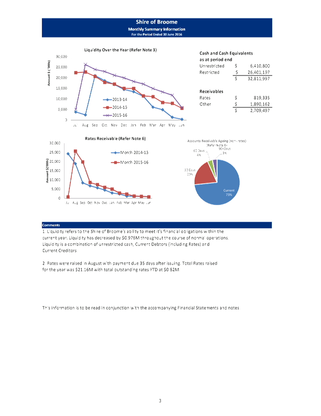
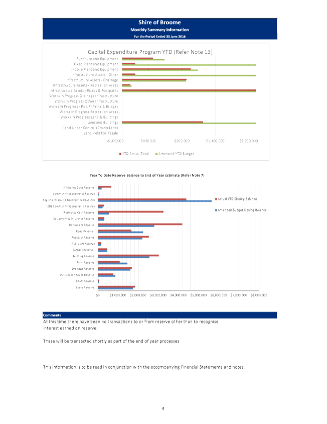
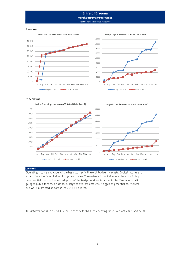
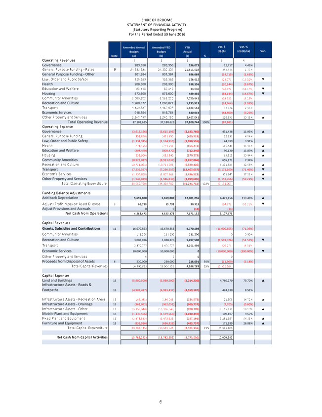
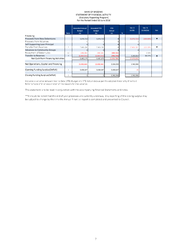
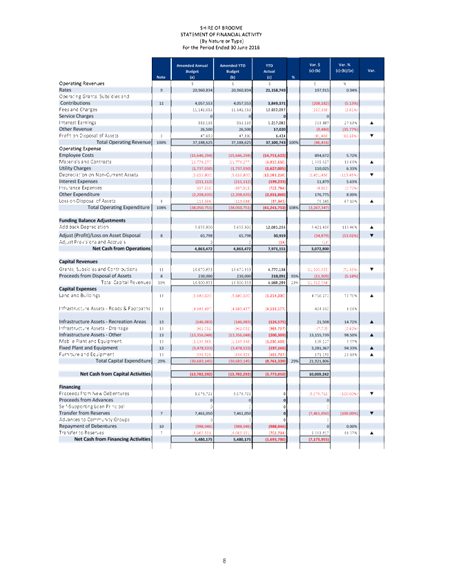

|
Item 9.4.2 - MONTHLY STATEMENT OF FINANCIAL ACTIVITY
REPORT JUNE 2016
|
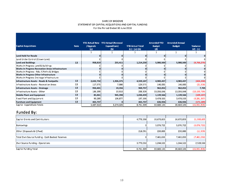
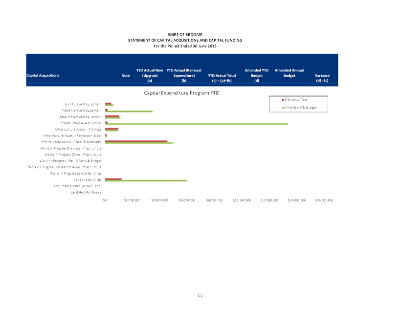
|
Item 9.4.2 - MONTHLY STATEMENT OF FINANCIAL ACTIVITY
REPORT JUNE 2016
|
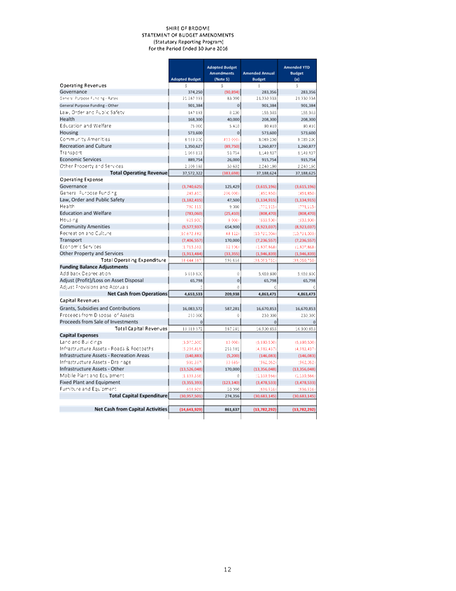
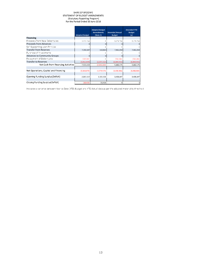
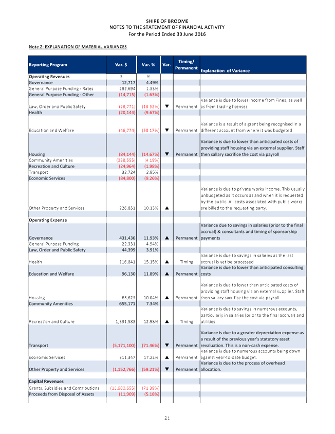
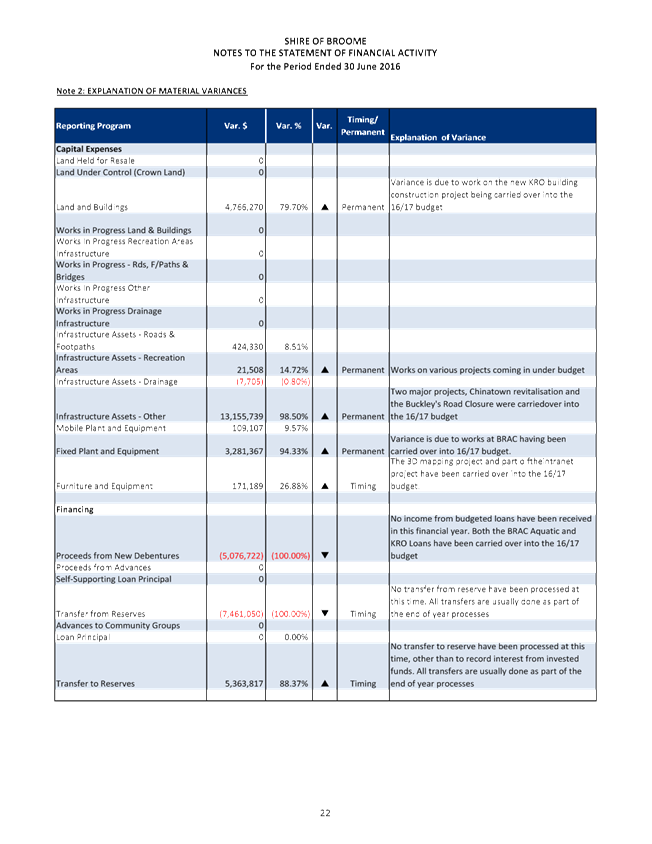
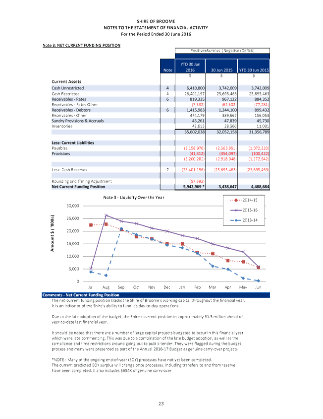
|
Item 9.4.2 - MONTHLY STATEMENT OF FINANCIAL ACTIVITY REPORT
JUNE 2016
|
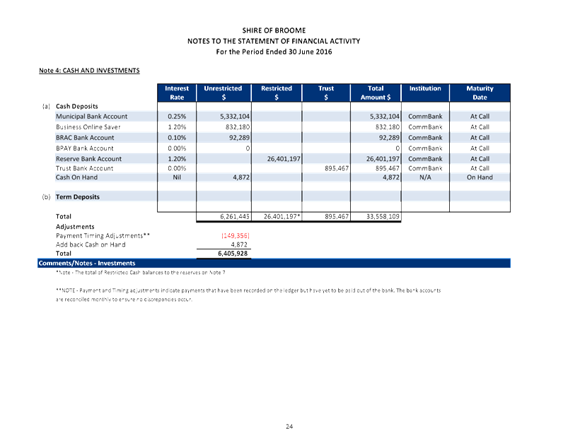
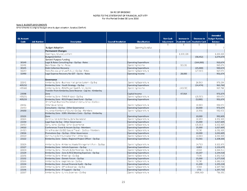
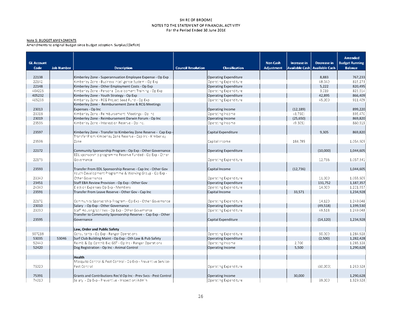
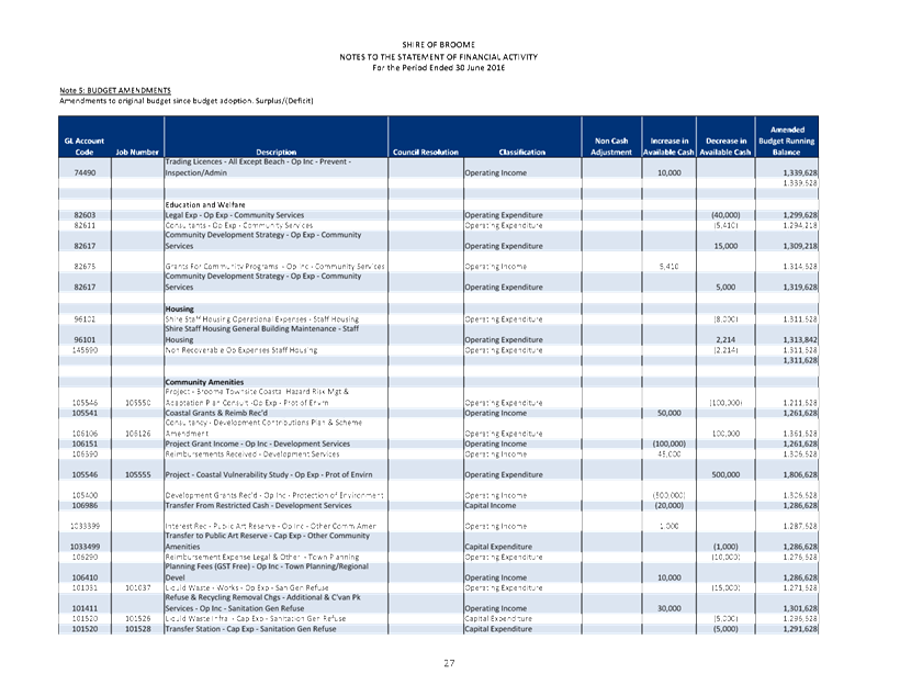
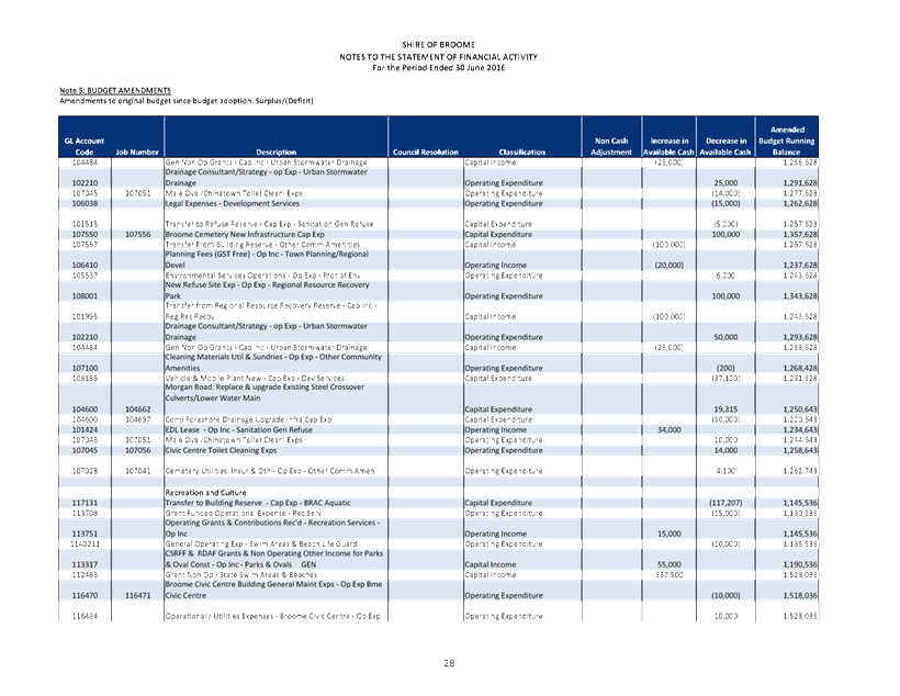
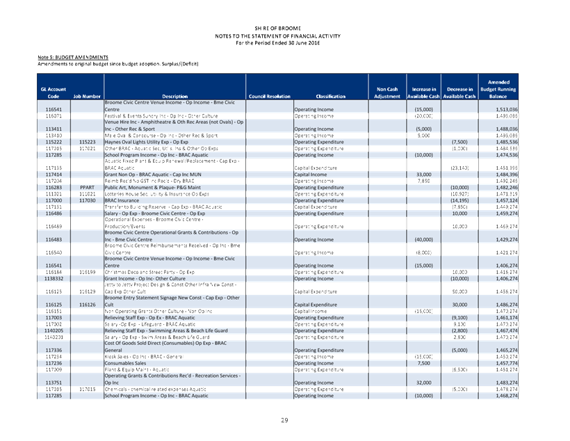
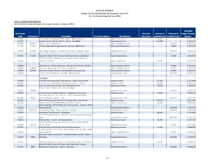
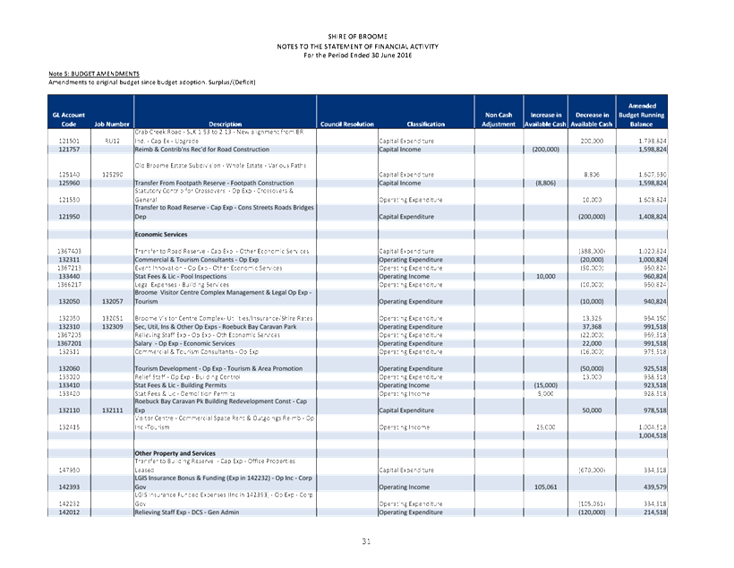
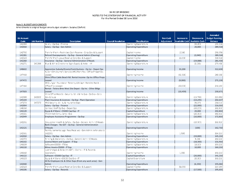
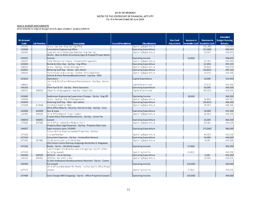
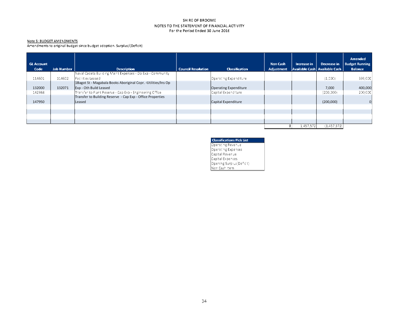
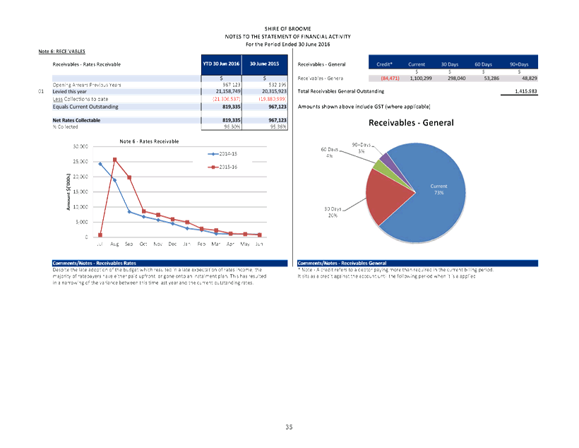
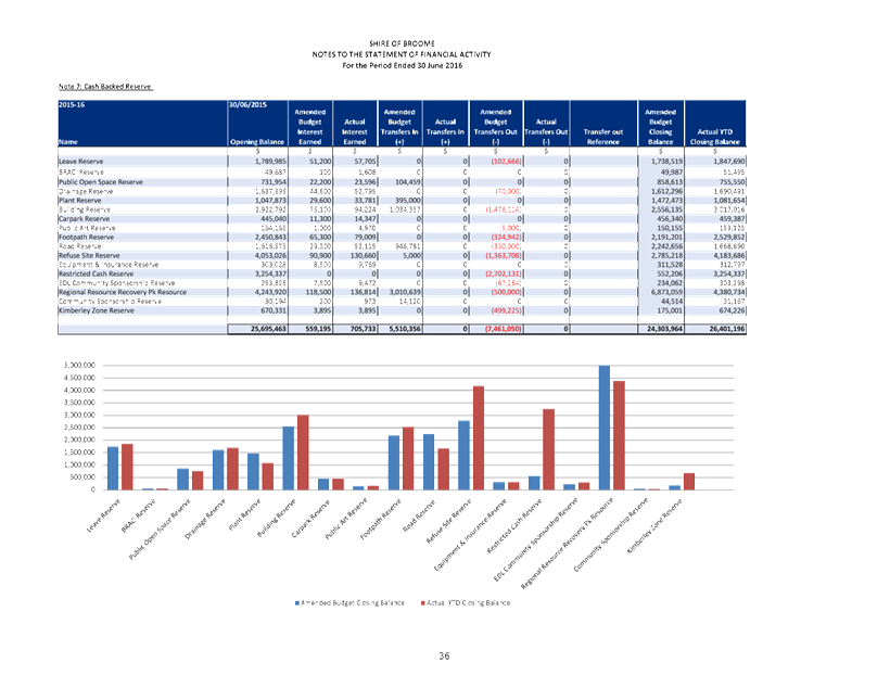
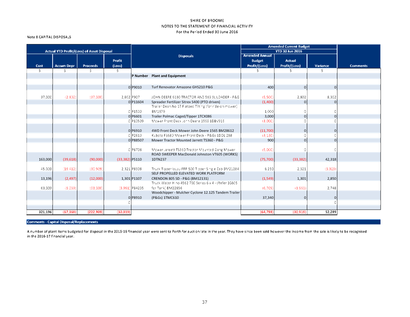
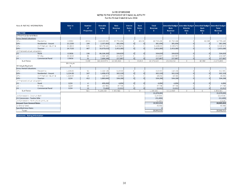
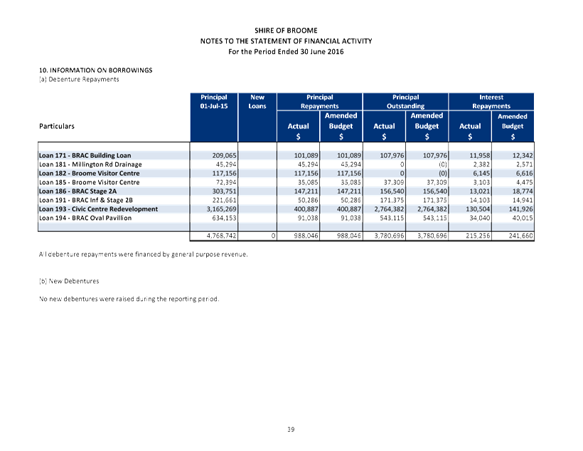
|
Item 9.4.2 - MONTHLY STATEMENT OF FINANCIAL ACTIVITY
REPORT JUNE 2016
|
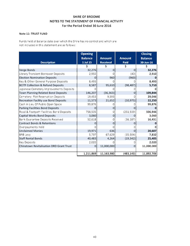
|
Item 9.4.2 - MONTHLY STATEMENT OF FINANCIAL ACTIVITY
REPORT JUNE 2016
|
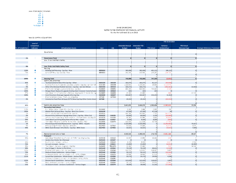
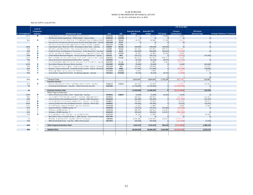
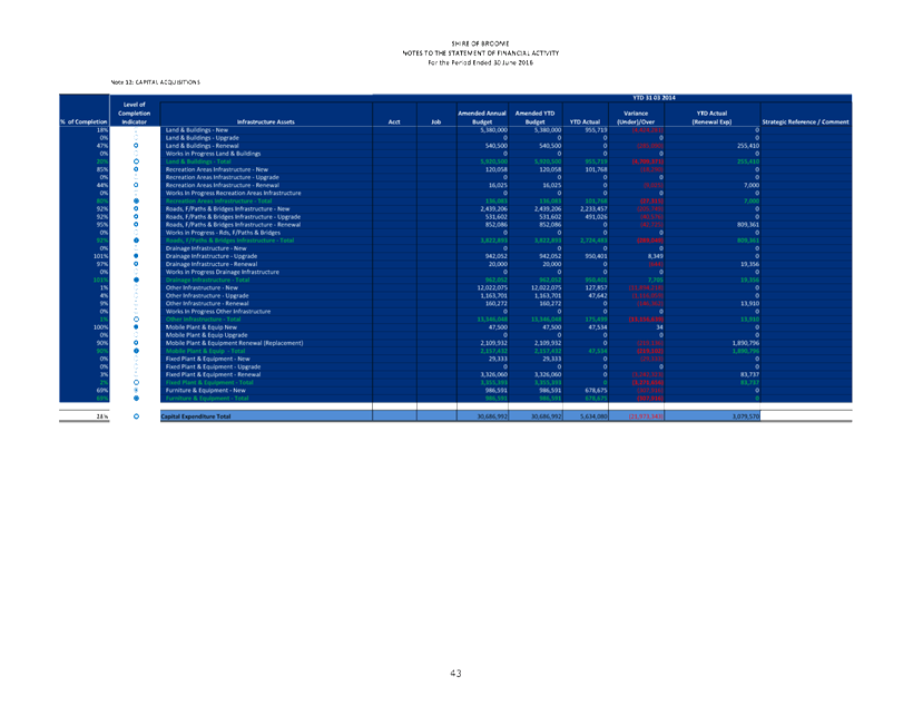
|
Item 9.4.2 - MONTHLY STATEMENT OF FINANCIAL ACTIVITY
REPORT JUNE 2016
|
SHIRE OF BROOME
Monthly
Statement of Financial Activity
For The Period Ending 30 June 2016
Appendix A: SUPPLEMENTARY NOTES TO
THE MONTHLY REPORT
NOTES TO THIS MONTH’S REPORT
OVERVIEW
For the period ended 30 June 2016,
the following are key indicators supporting the year to-date budget position
with respect to the Annual Forecast Budget:
Budget Year elapsed 100%
Total Rates Raised Revenue 100%
(of which 96.3% were paid)
Total Other Operating Revenue 98%
Total Operating Expenditure 108%
Total Capital Revenue
29%
Total Capital Expenditure 29%
Total Sale of Assets Revenue 95%
The budget was adopted at the Special
Meeting of Council on 13 August 2015. Council adopted a predicted end-of-year
deficit of $58,452 as part of the annual budget, which included approximately
$2.3 million of carry over surplus allocated to carry over projects and
quarantined 15/16 prepaid general purpose Financial Assistance Grants Scheme
funding.
The Annual Financial Report was
presented to Council at the October Ordinary Meeting of Council. The final
predicted end-of-year position was presented to Council indicating a further
$1.1 million of additional surplus. Recommendations were presented alongside
the Annual report proposing a transfer of the funds to reserve to help offset
the borrowing costs of drawing down the proposed loans to fund significant
projects. After the proposed amendments were adopted and applied to the budget,
the final impact increased the forecast end-of-year deficit to $150,533.
Further amendments as a result of the
first quarter Finance and Costing Review (FACR) were reviewed by the Audit
Committee on 15 December 2015 and adopted at the Ordinary Meeting of Council on
17 December 2015. The FACR process identified $552,500 of organisational
savings, but a further $449,533 in additional expenditure was identified
requiring offset by these savings. The adoption of first quarter FACR
amendments resulted in a predicted end-of-year position is a surplus of
$102,967.
The second quarter FACR commenced at
the end of the January, with the amendments review by the Audit Committee on 15
February 2016. The recommendations of the Audit Committee were put to Council
and adopted on 25 February 2016. The second quarter FACR identified $133,295 in
additional expenditure plus an additional $7,850 in organisational savings that
were recommended to transfer to reserve.
The third quarter FACR commenced in
April with the amendments reviewed by the Audit Committee on 10 May 2016. The
recommendations of the Audit Committee were put to Council and adopted on 26
May 2016. The second quarter FACR identified $797,613 in organisational
savings. It was recommended $704,459 be transferred to reserve with the balance
to be offset against the predicted deficit, resulting in a balanced budget.
A detailed list of all amendments
year-to-date can be found in Note 5 of the attached report.
It should be noted that the end of
financial year (EOFY) processes are currently in progress and this report
represents a snapshot at this time of where the budget is currently at. Due to
the ongoing processes, some figure reported may change. The Annual Financial
Report will be presented to Council once all processes have been completed and
report compiled.
ADJUSTMENTS TO DETERMINE THE CASH
POSITION
Budget Allocations
A budget amendment was made to reduce
the salary and superannuation accounts for Engineering staff in the third
quarter FACR due to savings from an unfilled vacant position. A budget
amendment was made to reduce plant fuel operating costs in the third quarter
FACR due to lower than expected increases in fuel prices.
CURRENT POSITION
The 2014/2015 Annual Financial
Statements have been finalised and were presented to Council through the Audit
Committee at the October Ordinary Meeting of Council. The final end-of-year
position for the 2014/2015 financial year, as reported in the Annual Financial
Statements, stands at approximately $3.4million which includes $1.5M of prepaid
annual Western Australia Local Government Grants Commission Financial
Assistance Grants Scheme funding and untied Road Grants funding, as well as the
net carried forward surplus for 2014/2015 projects of approximately $777K as
adopted in the 2015/2016 annual budget.
The remaining unallocated portion of
the surplus was presented to Council with the recommendation to transfer the
funds to reserve to assist in offsetting some of the expenditure from some of
the Shire’s major projects. These recommendations were adopted and the
amendments applied in October. The budget, along with the application of the
end-of-year surplus, was adopted with $58,453 deficit.
Year-to-date, after all amendments
adopted by Council, including the first, second and third quarter Finance and
Costing Review (FACR), the predicted end-of-year position is a balanced budget.
Currently, at the end of June, the
current position stands at $5.9M, however EOFY processes will likely change
this final current position.
Cash
Total Cash Assets are now $32.81M
having decreased by $4.38M from the previous month.
The major
revenue items this month include receipt of:
· $84K from the ATO
for the refund of GST;
· $83K from the
Department of Planning for grants related to 2 projects;
· $83K from
Significant Ratepayers;
· $60K from Broome
Visitor Centre for outstanding rent and outgoings.
The major
expenditure items this month include payments of:
· $789K
to Pearl Coast Properties for work done on the Frederick St Drain Project;
· $348K
to Roadline for works done on the Archer St Project;
· $293K
in to Rosmech for the purchase of a new road sweeper;
· $293K
to Western Australian Treasury Corporation for the final 15/16 instalment on
the Shire’s loans;
· $202K
to Horizon Power for utility and street lighting charges;
· $197K
to AAA Asphalt for works done on the Hamerlsey and Hass St project;
· $175K
to McCorry Brown Earthmoving for the provision of plant on the Hamerslay and
Haas St Project;
· $136k
to Broome Builders for work done on numerous projects;
· $117K
to WA Hino for the provision of a new piece of plant;
· $96K
to Toxfree for the provision of recycling services.
Receivables
Sundry debtors including GST
refundable stand at $1.89M, having increased by $945K from the previous month.
Rates and rubbish debtors stands at
$812K; having decreased by approximately $265K against the previous month as
outstanding ratepayers continued to pay their rates.
Other Assets
These stand at $87.9K, having
decreased by $363 from the previous month.
Cash Liabilities
These have been reduce to nil by 30
June, as we paid our final loan instalment for the financial year.
Creditors and Payables
Sundry Creditors are $2.83M, as
invoices were processed and/or are paid. This represents an increase of $1.72M
from the previous month.
Other Payables comprising Tax
Payable, FESA Levy Collected, Accrued Loan Interest, Prepayments Received and
accruals stand at $333K, having increased by $107K from the previous month.
Employee Provisions and Accruals
In the normal course of events, these
figures are adjusted in June and July each year by end of year accounting
adjustments.
Currently leave provisions are
$1,889K. Accruals to reflect the year end position have been completed for the
2014-2015 year.
|
Item 9.4.2 - MONTHLY STATEMENT OF FINANCIAL ACTIVITY REPORT JUNE 2016
|
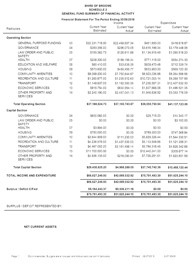
|
Item 9.4.2 - MONTHLY STATEMENT OF FINANCIAL ACTIVITY REPORT JUNE 2016
|
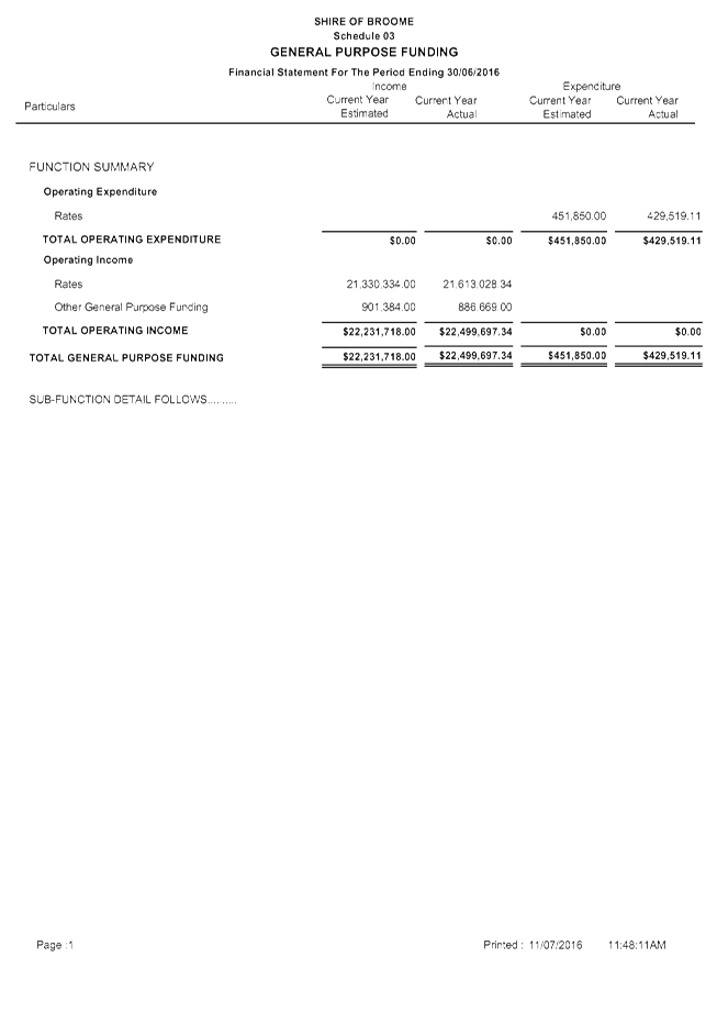
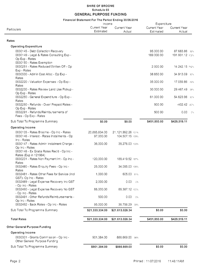

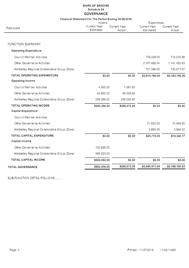
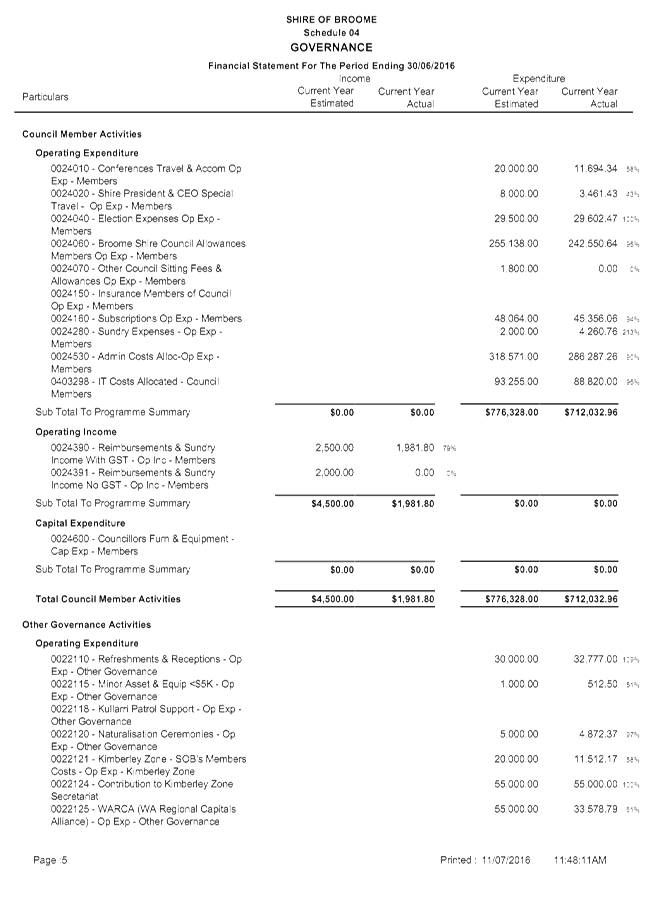

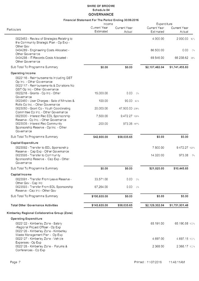

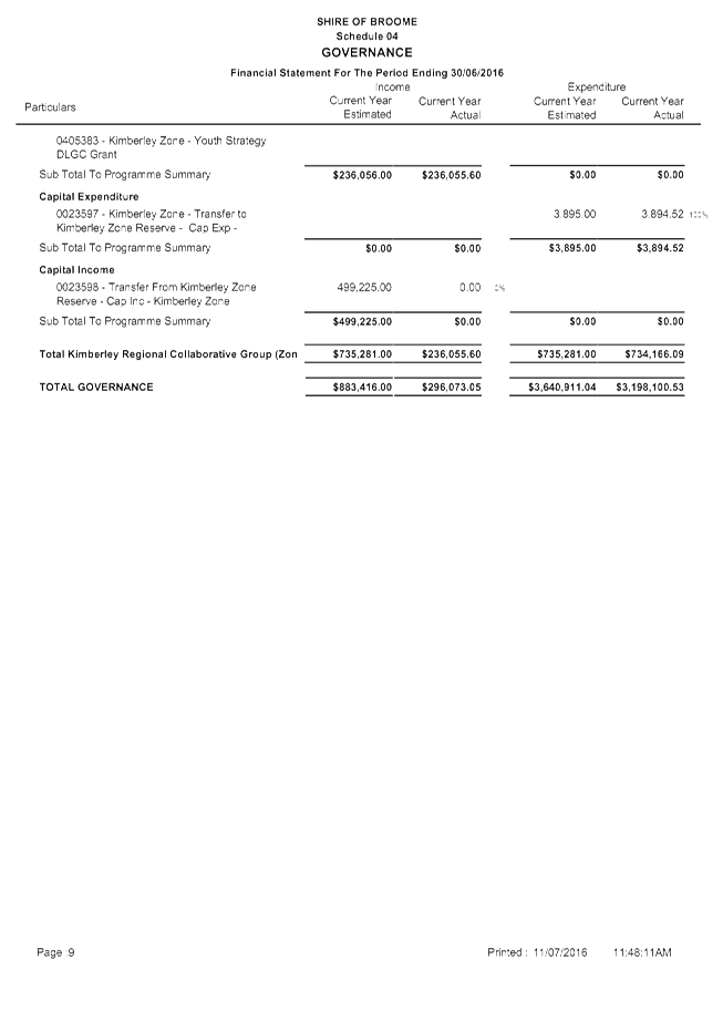
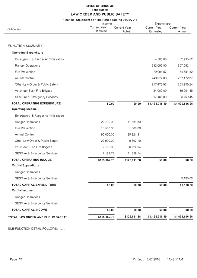
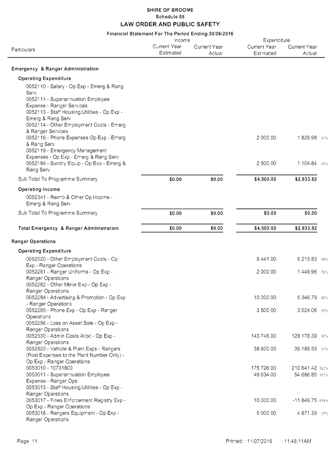
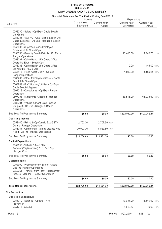
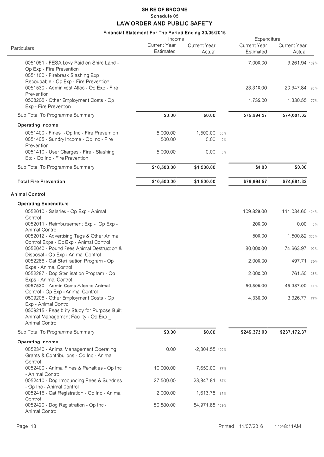
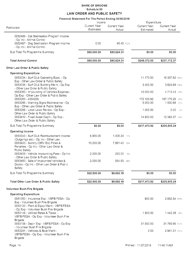
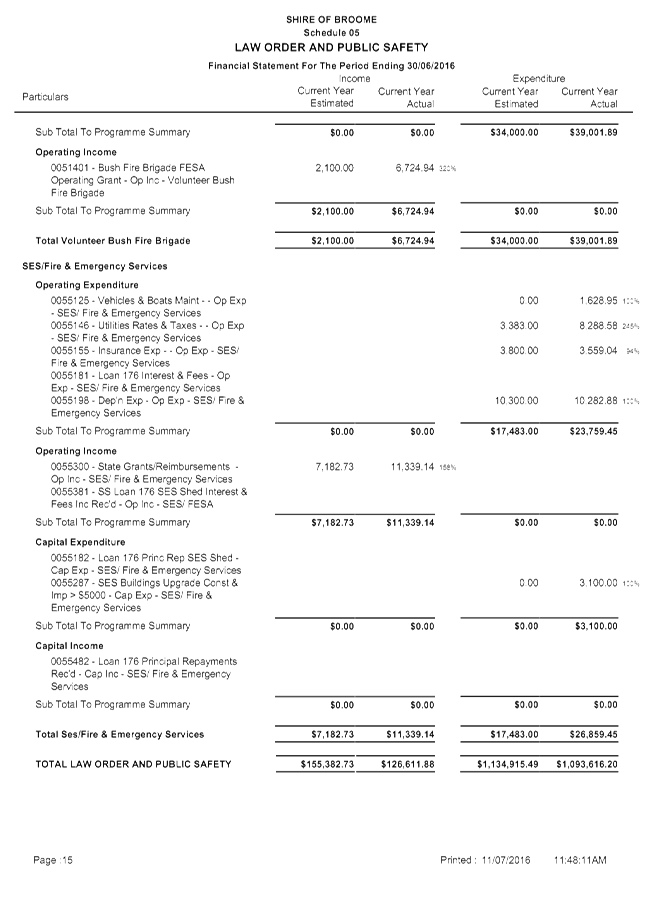
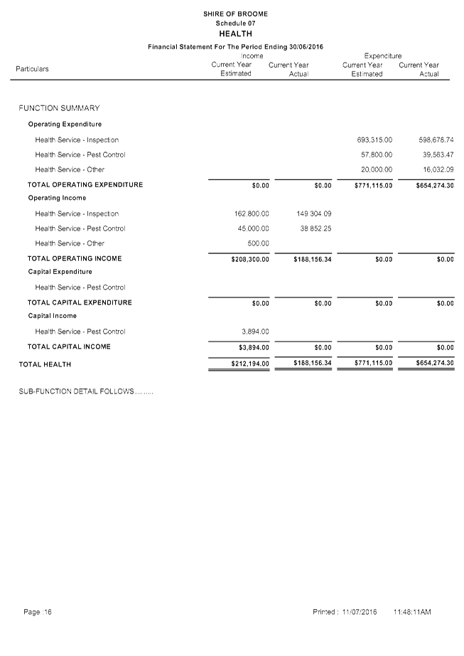
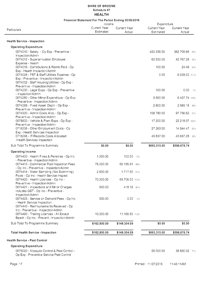
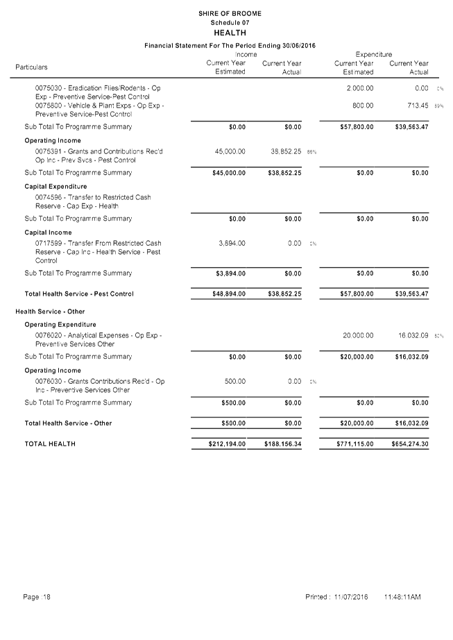
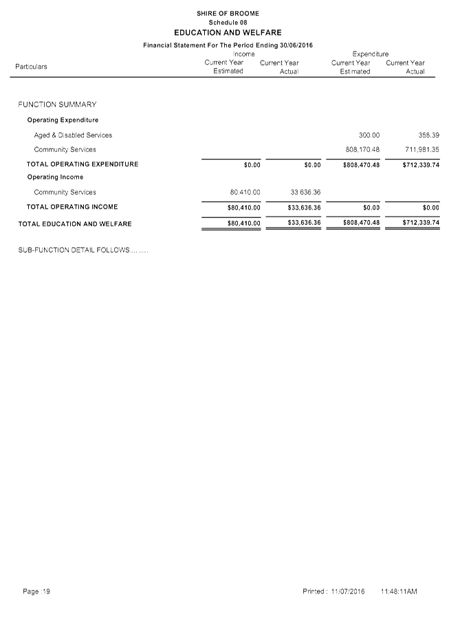
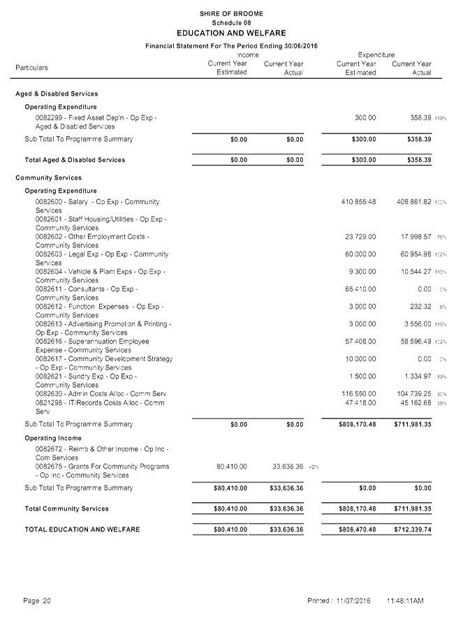
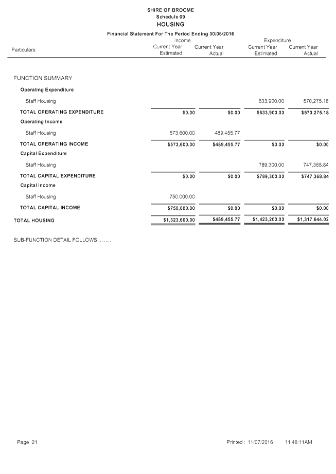


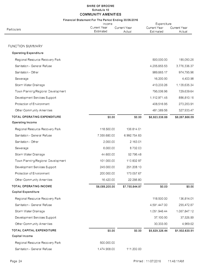


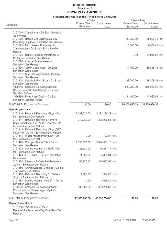

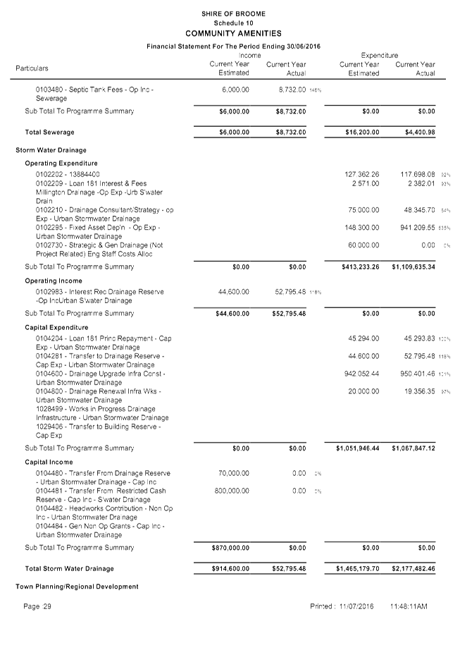
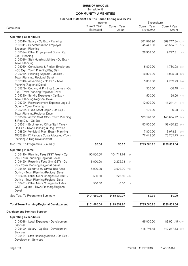
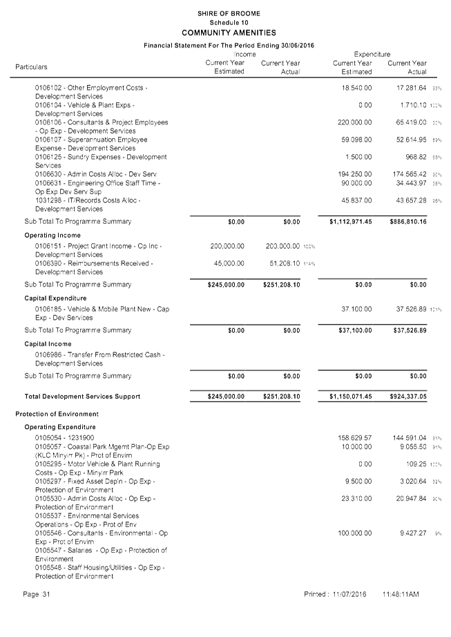
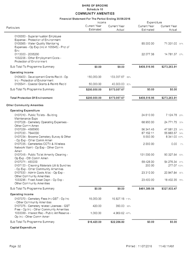
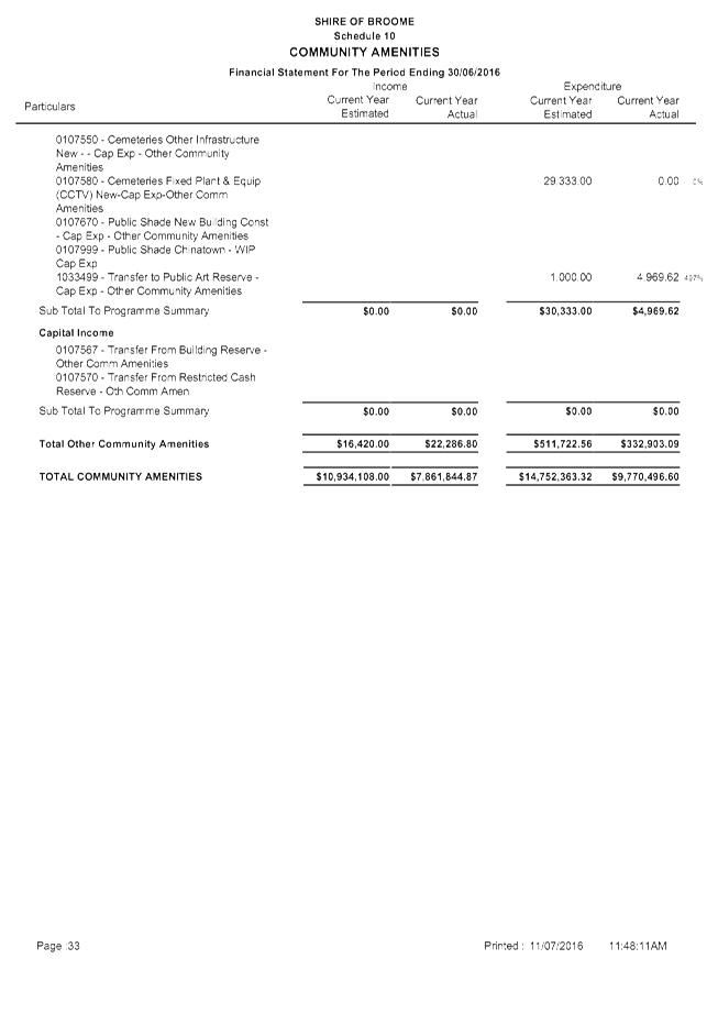
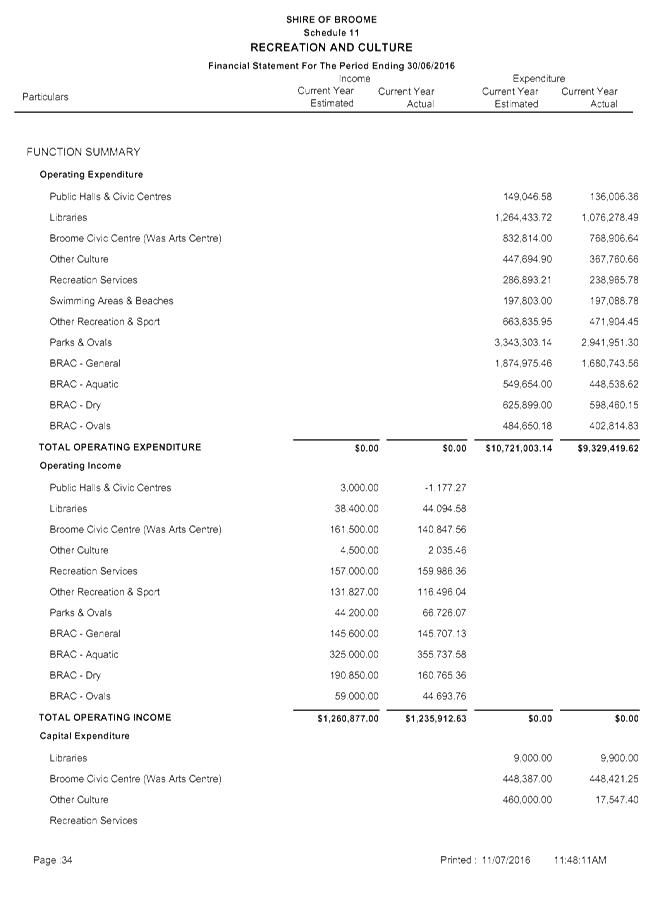
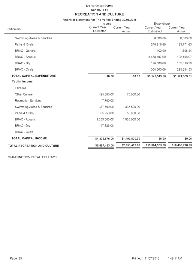
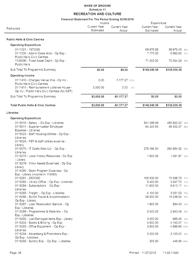
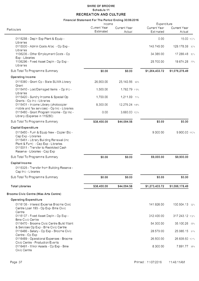


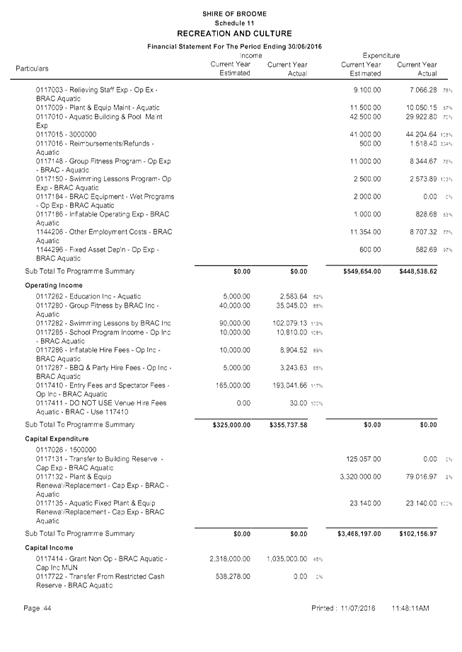


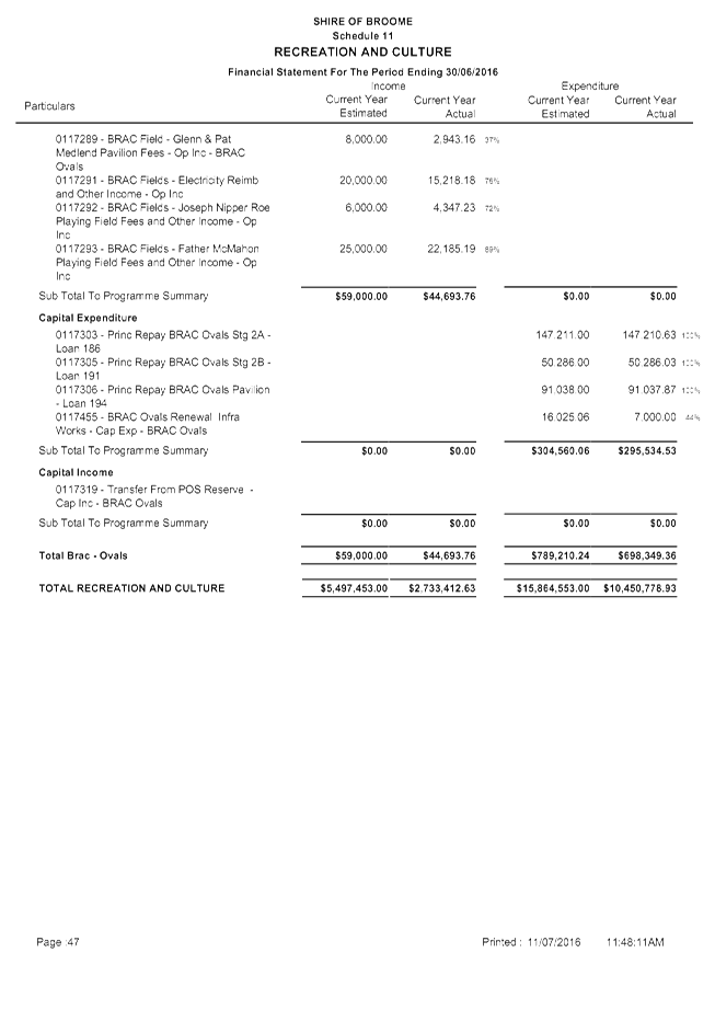
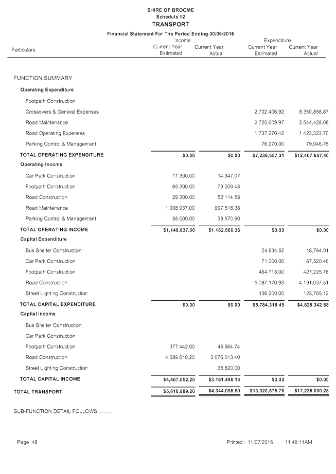
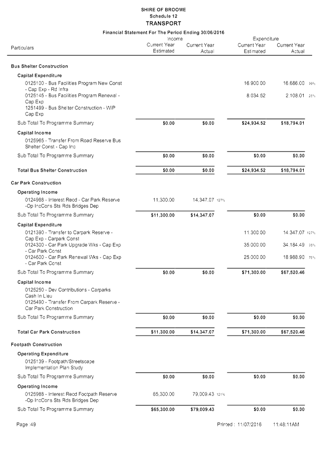
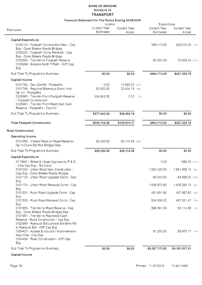

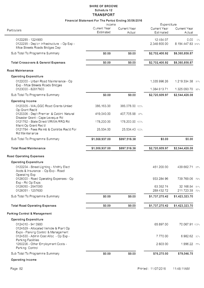

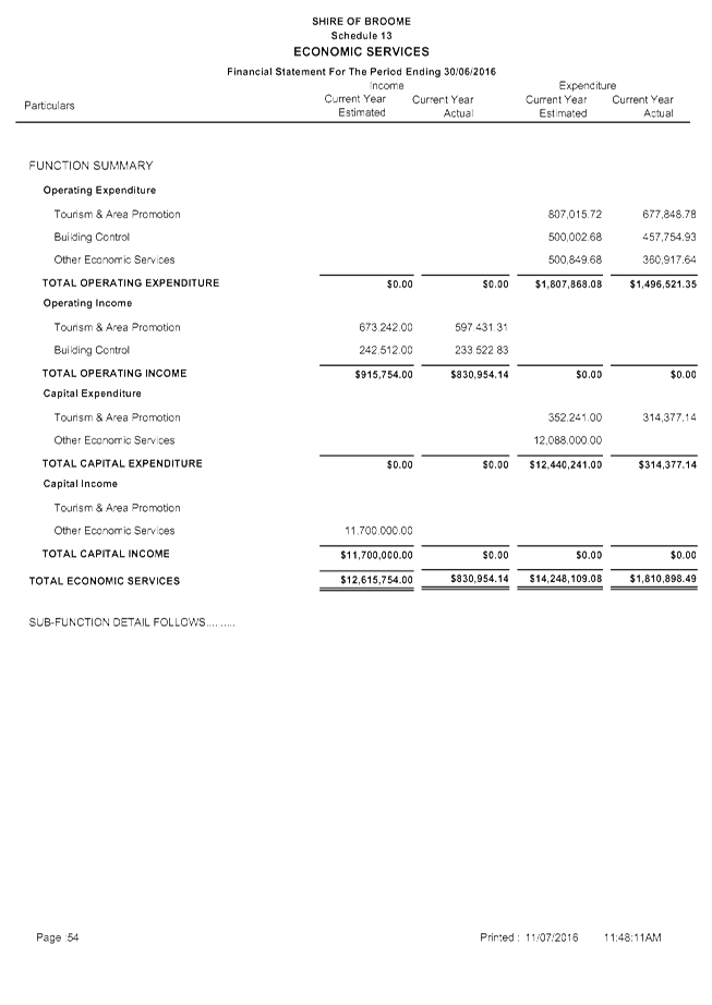
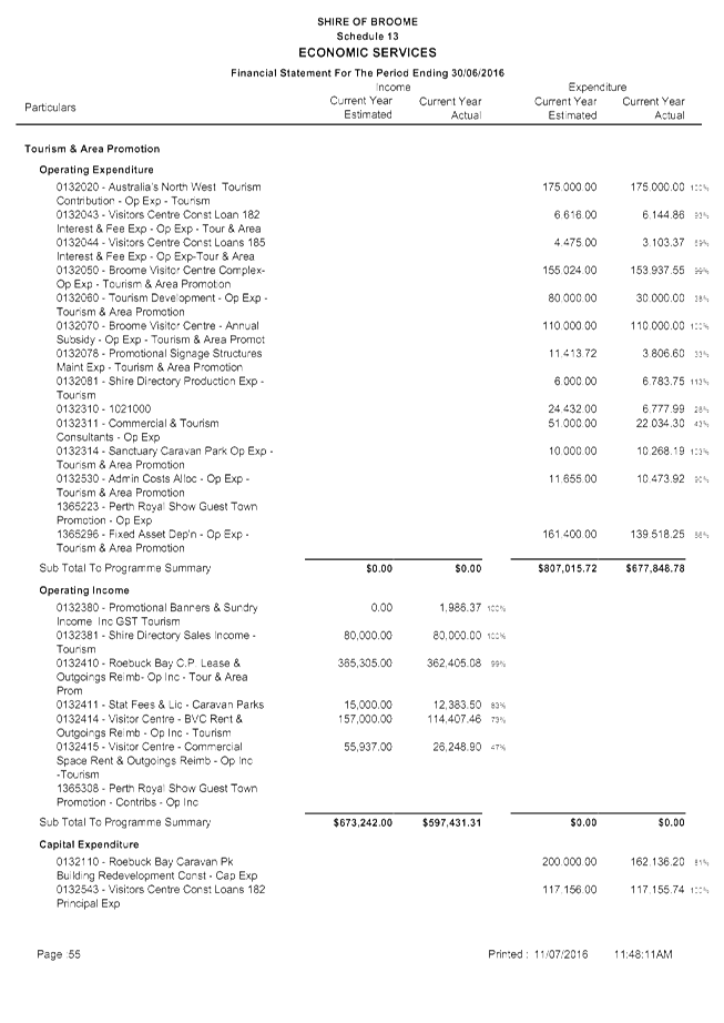
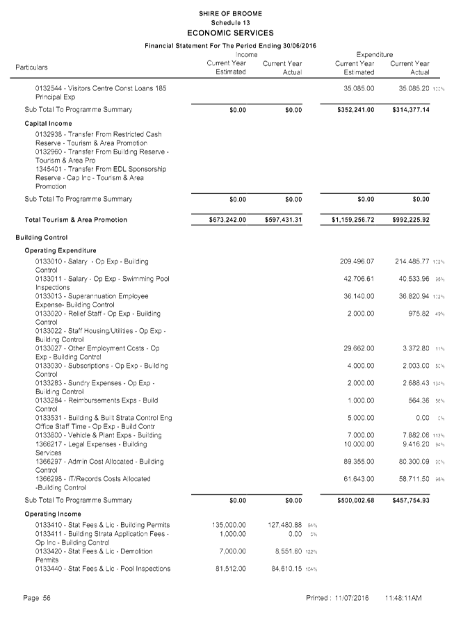
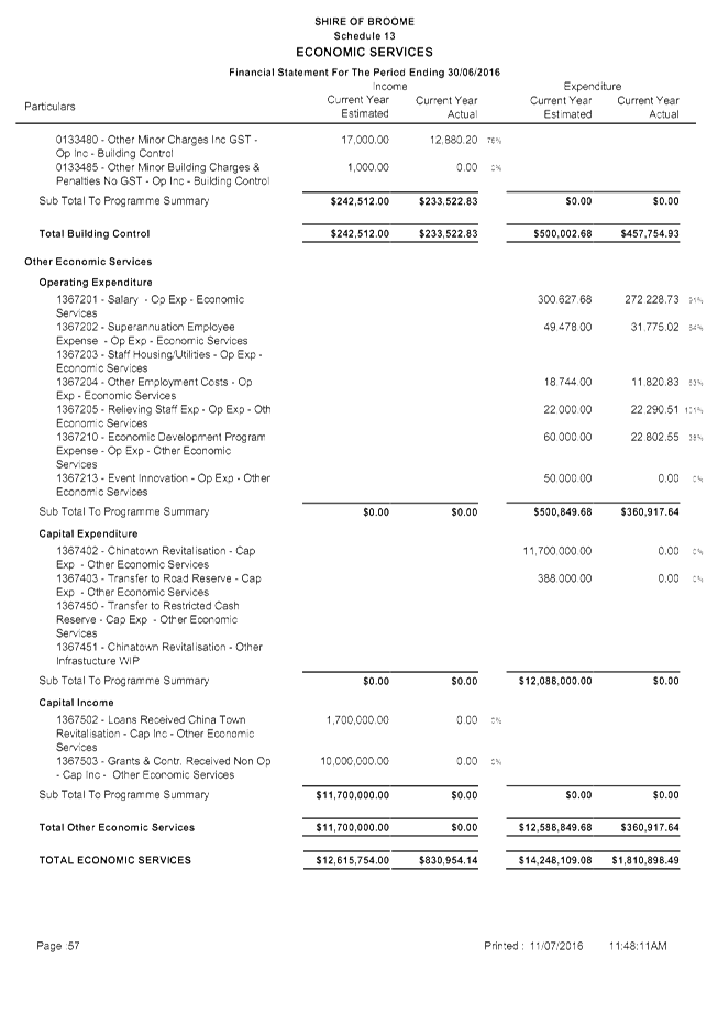
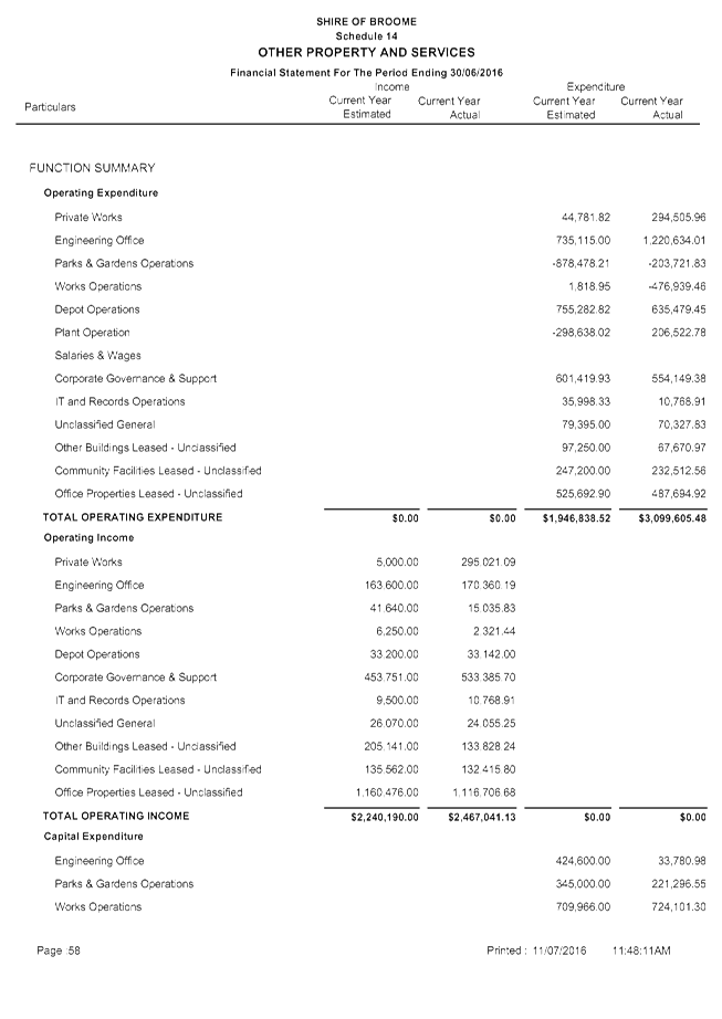
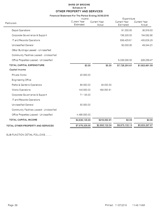
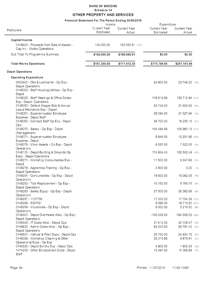
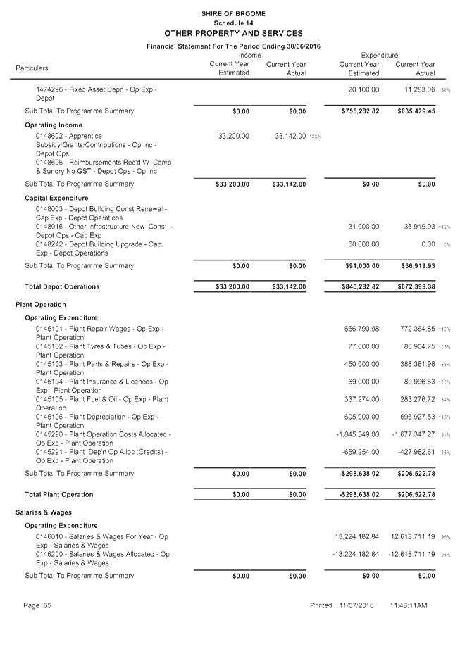
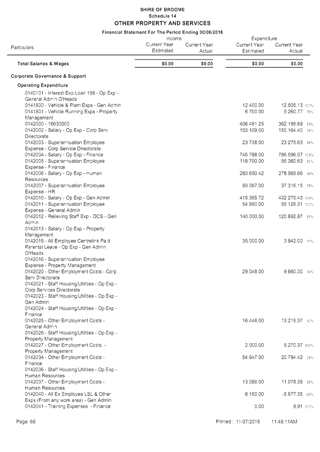

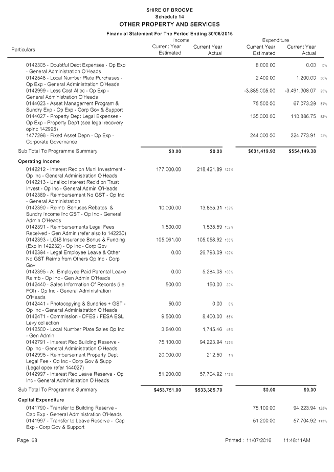
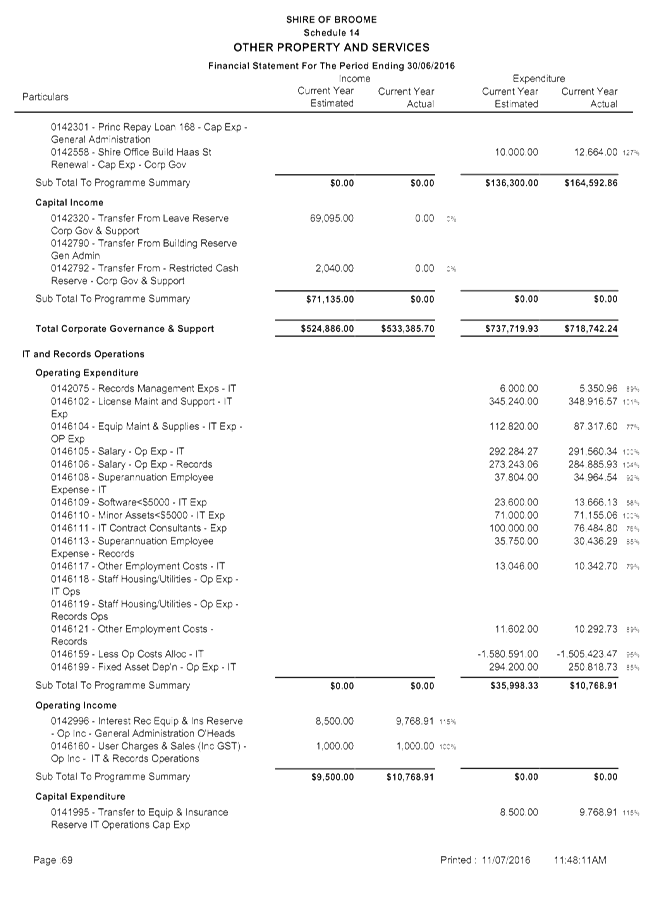
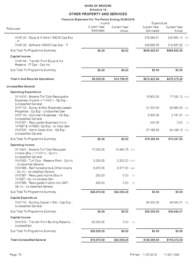
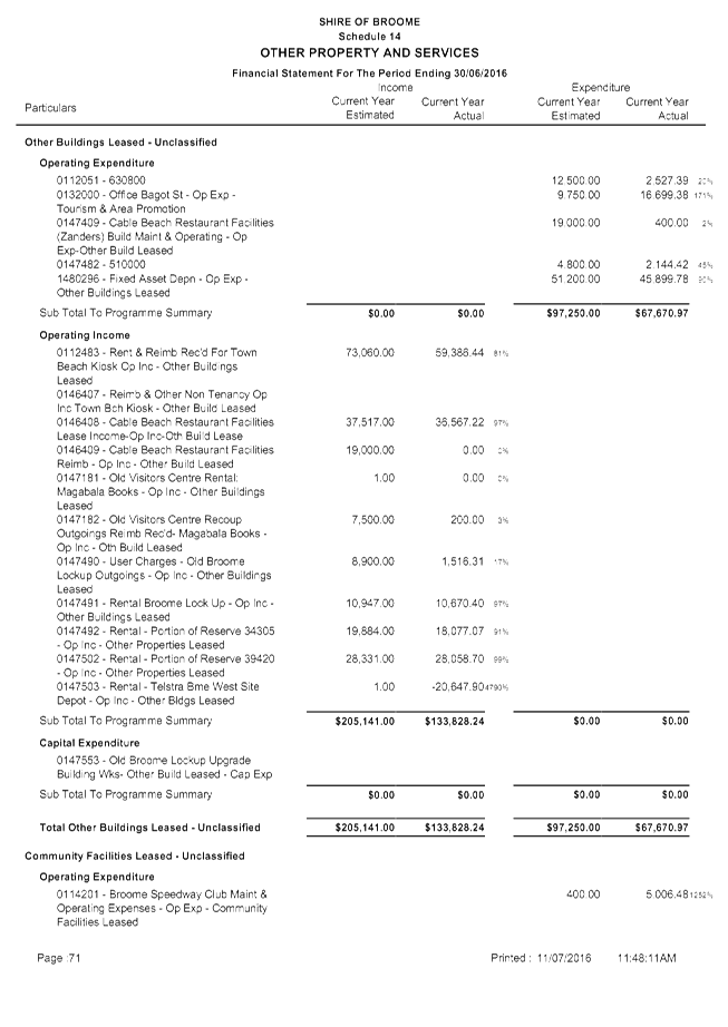
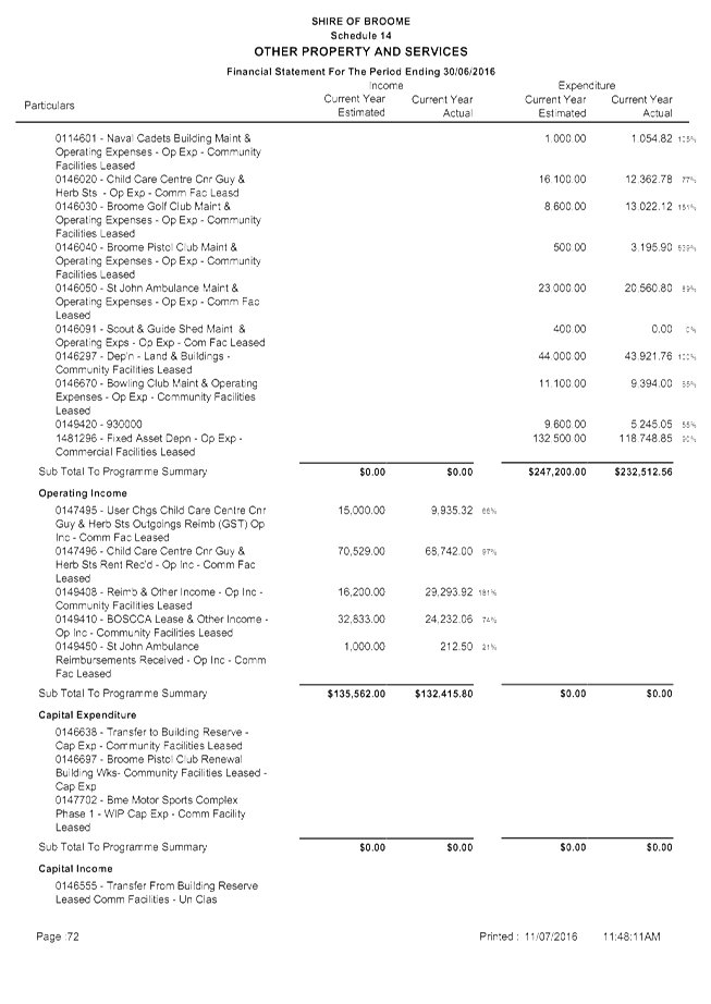
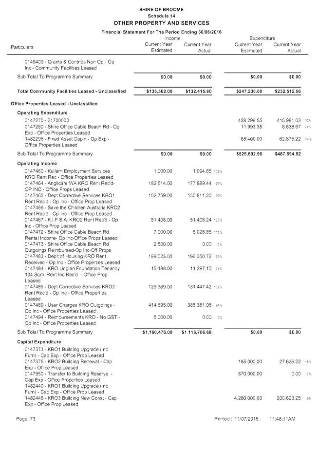
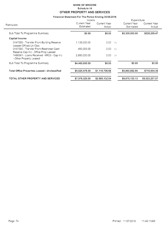
|
9.4.3 PROPOSED POLICY RATE
EXEMPTION - CHARITABLE USE
LOCATION/ADDRESS: NIL
APPLICANT: NIL
FILE: ARA11
AUTHOR: Manager
Financial Services
CONTRIBUTOR/S: Nil
RESPONSIBLE
OFFICER: Acting
Director Corporate Services
DISCLOSURE
OF INTEREST: NIL
DATE OF REPORT: 11
July 2016
|
|
SUMMARY: Council
requested the Chief Executive Officer (CEO) to develop a policy to provide
guidance on the assessment of future applications for rate exemptions for
charitable use (Charitable Use Exemptions). After extensive industry research
and legal advice, officers have developed a draft policy for Council
adoption.
|
BACKGROUND
Previous
Considerations
OMC 24 May 2005 Item
9.4.3
OMC 26 February 2015 Item
9.1.4
A number of applications for
charitable use rate exemptions have been presented to Council on a case by case
basis recently. Currently there is no rating policy to guide the assessment of
applications for Charitable Use Exemptions. An extract of the resolution of the
OMC held 26 February 2015 Council is as follows:
2. Requests
the Chief Executive Officer to lobby the State and Federal governments on the
matter of the increasingly onerous financial burden caused by charitable use
rate exemptions.
3. Requests
the Chief Executive Officer to develop a policy to provide guidance on the
assessment of future charitable rate exemption applications.
The scale and extent of applications
recently presented to Council, combined with the broad and liberal application by
judicial authorities of Common Law definitions of ‘charitable
purpose’ in case law precedents on this subject matter, has prompted the
need to develop an assessment framework to provide guidance. Officers have
drafted the attached proposed policy ‘Rate Exemption – Charitable
Use’ in response to point 3 of the resolution. The report to Council made
comment on the lack of local government industry guidelines or assessment
framework to assist officers and Council in the decision-making process in
regards to Charitable Use Exemption applications. The following summarises what
has been previously reported to Council and the issues faced by local
governments.
Council previously resolved a
position in regards to the assessment of applications for Charitable Use
Exemptions. In the report to Council at the OMC held on 24 May 2005, Council
was advised that:
“At present there is no
comprehensive administrative assessment process that covers the wide variety of
exemption queries that the Shire is receiving and enquiries regarding rates
exemption are increasing. Ordinarily this would be an administrative matter,
however, the lack of clarity and potential ramifications of the interpretation
warrants the issue being brought to Council’s attention and endorsement.”
At the OMC held 24 May 2005, Council
was presented a draft policy position on the rating of charitable organisations
and State Government owned entities. The policy was prepared by the Western
Australian Local Government Association (WALGA) as a result of an inquiry
conducted by the Local Government Advisory Board. Advice received stated that
Local Governments in WA forgo approximately $6.5 million annually for land used
for charitable purposes. The Council report identified that the draft
guidelines contained some deficiencies relevant to its intended purpose which
was to clarify the criteria for the assessment of “land used for an
exclusive charitable purpose”.
The report’s author deemed that
the draft tended to focus more on the manner in which Local Government should
assess the status of an organisation (i.e. whether or not the applicant was
considered charitable), rather than whether the land was used for a charitable
purpose. This was considered to be in contrast to the requirements of the
Local Government Act 1995 (LGA) which specifically references the use
of the land as opposed to the ownership thereof.
The following resolution was passed
at the OMC held 24 May 2005:
1. That
Council notes the WALGA draft Criteria and Guidelines for Assessing Exemptions
from the payment of rates.
2. That
Council will continue to assess rates exemption applications according to land
use on a case by case basis.
In 2015, WALGA published the ‘Rates
and Charitable Land Use Exemption Applications Best Practice Guideline’
which officers have reviewed. The document has improved on the 2005 draft by
emphasising ‘land use’ and providing a summary of key State
Administrative Tribunal (SAT) decisions. These decisions provide context for
the treatment of the land uses that have set legal precedents.
Despite these improvements officers
maintain support for the assessment of rate exemption applications on a case by
case basis. This ensures a fair and equitable approach to objectively reviewing
land use subject to claims of being a ‘charitable purpose’. To
support this individual case assessment basis, officers have developed a policy
and supporting business operating procedure. Consideration and adoption of the
draft policy has also been included in this agenda and its objective is to
assist Council and officers in the administration and assessment of rate
exemption applications.
In researching the background to
previous assessments of Charitable Use Exemptions and in the development of the
policy, it is evident that there is no clear definition of
“charitable” or “charitable purpose” within the
LGA. This is an ongoing issue for Local Governments in general and does
provide challenges when assessing such applications. The absence of a
definition of ‘charitable purpose’ in the LGA leads Officers to
rely on the preamble to the Charitable Uses Act 1601. Lord Macnaghten
classified four principal “trusts” (divisions/categories) deemed to
be “charitable purpose” as set out in Pemsel’s rule (1891)
which included:
· Advancement of
Education;
· Advancement of
Religion;
· Relief of Poverty;
and
· Other purposes
beneficial to the community not falling under any of the preceding categories.
Although this Imperial legislation is
very dated, legal advice and advice from the Department of Local Government and
Communities (DLGC) confirms that it is still referenced in court and within
State Administrative Tribunal (SAT) proceedings to this day. The above
charitable principles still do not identify specifically what activities are
charitable. In the absence of definitive descriptions of specific charitable
activities, legal advice has instructed officers to rely on previous
determinations and benchmarks set in case law precedents. This presents
difficulty and ambiguity to officers assessing Charitable Use Exemptions as the
interpretation of case law decisions is open to subjective bias and often
requires specialised legal advice. Additionally, local government officers do
not have access to the case law resources available to members of the legal profession.
In acknowledgement of the above
challenges, these benchmarks and tests for land use activities which have been
determined through case law precedents, provide the assessment framework for
officers and Council. These various judicial decisions have expanded on the Charitable
Uses Act 1601 and also determined that a charitable purpose must
satisfy a public benefit test. In a common law context, the public benefit test
has been determined as meaning, “a sufficient section of the community
must benefit from the charitable purpose, not just a small group”. This
is supported by the findings in Williams' Trustees V Inland Revenue
Commissioners 1947 AC 447 where a charitable gift to a select group of
individuals, did not fit the definition of ‘charity’ as the benefit
was received by only a small section of the public. Further complexity lies in
the varying activities conducted on land by charitable bodies including revenue
raising and administrative functions. Each Charitable Use Exemption application
can vary considerably depending on the individual facts of the case. Officers
and Council then rely heavily on interpreting and applying determinations and
tests set by case law precedents creating a number of risks discussed in
further depth below.
Section 6.26(1) of the LGA states
that all land within a district is rateable land, unless an exemption applies.
The draft policy relates specifically to Section 6.26(2)(g), which in summary
states:
(2) The
following land is not rateable land –
(g) land used
exclusively for charitable purposes.
As a reflection of the Shire’s
current Charitable Use Exemption application procedures, the draft policy and
associated operating procedure requests the applicant demonstrate how and why
they consider their land to be used exclusively for charitable purposes in
accordance with Section 6.26(2)(g).
Officers have examined this provision
in the LGA, including research of current industry literature, and sought legal
advice on the interpretation of the provision and its application in several
situations. The lack of definition of the terms ‘use’,
‘charitable purpose’ and ‘exclusively’ in the LGA is
cited as a source of ambiguity across the local government industry, and raises
concerns of a lack of uniform treatment of rate exemption applications for
charitable purposes. This increases the potential risk of unnecessarily lost
rate revenue to local governments and inconsistent determinations by separate
local governments for applicants with properties of similar land use.
The risk of revenue loss due to
inconsistency in exemption determinations has far reaching impacts on a local
government’s ability to maximise rate revenue. Rates are a service charge
and within the Shire of Broome are based on differential rating. The objective
of rates is to make up the shortfall between budgeted income from other sources
(e.g. fees and charges, licences, government grants etc.) and proposed
expenditure. The increase in charitable rate exemptions results in a wider
shortfall to be made up from other sources of revenue where local governments
have limited ability to generate income other than rates.
Additionally, the annual budget
deficit to be funded by rates remains the same regardless of the change in
rateable status of properties on the database. It is all other owners in the
district that bear the impact should properties become non rateable. This is
the underlining principle of a taxation system of fairness and equity where all
properties are rateable and should contribute a fair amount to the annual
budget deficit based on a taxation system that is also transparent, objective,
consistent and administratively efficient. The annual budget deficit represents
the costs to deliver goods and services, minus any other revenue, to all members
of the district in delivering the function of local government, being good
governance for the benefit of all residents and visitors to the district. Rates
are not a fee for service, measurable against what individual properties
receive or do not receive from the Shire.
This policy and its associated
administrative procedure are suggested so as to improve the assessment
framework for the consideration and administration of Charitable Use Exemption
applications by officers and the Council. It is also clear from reviewing the
rating database, that there has been a lack of understanding in the past in
relation to recording relevant details of the Charitable Use Exemption on the
property record. It is an outcome of this framework to improve the standard of
accuracy and data integrity in the Shire’s property database.
Additionally, by implementing a system of regularly reviewing Council’s
Charitable Use Exempt properties, this ensures the maximisation of rate revenue
to lessen the burden on the Shire’s existing ratepayers.
COMMENT
Establishing this policy is the first
step in providing Council with a strong framework around rating exemptions.
While most of the sections within the legislation are relatively easy to
interpret in relation to whether land may be non-rateable and therefore exempt
from paying rates, the lack of supporting definitions of section 6.26(2)(g)
creates a level of difficulty. The draft policy provides an important framework
for officers and the Council to ensure that an accurate interpretation is made,
decisions are accurate, and Charitable Use Exemptions are determined on the
basis of fairness, equity, consistency, objectivity and administrative
efficiency.
The challenge to officers still
remains however, in terms of the lack of discretion in setting rules on what
constitutes a charitable purpose. The assessment framework cannot supersede
legislative determinations in the LGA or case law precedents. In assessing
applications for Charitable Use Exemptions, the onus is on the assessor to research
and interpret tests, determinations, and benchmarks set in case law precedents.
The challenge presented here is that the law is an ever evolving beast. This
means, a previous determination can be overruled in the future by other cases
decided on at law. This results in exorbitant legal costs for the local
government industry to seek legal advice every time it receives an application
for a Charitable Use Exemption.
In addressing these challenges, the
Shire of Broome is collaborating with the member Councils of the Western
Australia Regional Capitals Alliance (WARCA) and the WALGA Regional
Collaborative Zone of the Kimberley (KZRCG), are in the process of lobbying the
State and WALGA to change the LGA to include charitable purpose definitions as
per point 2 of Council’s resolution in the OMC held 26 February 2015. So
far, the Shire of Broome has collated data from the member Councils and
presented this in a report to the June 2016 WARCA meeting. At the July 2016
KZRCG meeting, the members resolved to create a working group to progress the
lobbying process.
Officers have undertaken a broad
process of canvassing and researching the available rate exemption policies
from other Councils. The initial draft then underwent an extensive external
consultation process. The draft was reviewed and comments were provided from
senior officers at the DLGC and WALGA. Herbert Smith Freehills were contracted
to undertake a legal review of the draft policy. On review of the legal advice
on the draft policy, officers sought to separate the document into a policy and
administrative business operating procedure. The final documents provide
Council and officers with a guidance framework for assessing applications for
Charitable Use Exemptions.
It is recommended that Council adopt
the draft Policy – Rate Exemptions – Charitable Use.
CONSULTATION
Herbert Smith Freehills
Department of Local Government and
Communities
Western Australia Local Government
Association
STATUTORY ENVIRONMENT
Local Government Act, 1995
Division 6 — Rates and
service charges
Subdivision 1 —
Introduction and basis of rating
6.26. Rateable
land
(1) Except
as provided in this section all land within a district is rateable land.
(2) The
following land is not rateable land —
(a) land
which is the property of the Crown and —
(i) is
being used or held for a public purpose; or
(ii) is
unoccupied, except —
(I) where
any person is, under paragraph (e) of the definition of owner in
section 1.4, the owner of the land other than by reason of that person
being the holder of a prospecting licence held under the Mining Act 1978
in respect of land the area of which does not exceed 10 ha or a miscellaneous
licence held under that Act; or
(II) where
and to the extent and manner in which a person mentioned in paragraph (f)
of the definition of owner in section 1.4 occupies or makes use of the
land;
and
(b) land
in the district of a local government while it is owned by the local government
and is used for the purposes of that local government other than for purposes of
a trading undertaking (as that term is defined in and for the purpose of
section 3.59) of the local government; and
(c) land
in a district while it is owned by a regional local government and is used for
the purposes of that regional local government other than for the purposes of a
trading undertaking (as that term is defined in and for the purpose of
section 3.59) of the regional local government; and
(d) land
used or held exclusively by a religious body as a place of public worship or in
relation to that worship, a place of residence of a minister of religion, a
convent, nunnery or monastery, or occupied exclusively by a religious
brotherhood or sisterhood; and
(e) land
used exclusively by a religious body as a school for the religious instruction
of children; and
(f) land
used exclusively as a non‑government school within the meaning of the
School Education Act 1999; and
(g) land
used exclusively for charitable purposes; and
(h) land
vested in trustees for agricultural or horticultural show purposes; and
(i) land
owned by Co‑operative Bulk Handling Limited or leased from the Crown or a
statutory authority (within the meaning of that term in the Financial
Management Act 2006) by that co-operative and used solely for the storage
of grain where that co-operative has agreed in writing to make a contribution
to the local government; and
(j) land
which is exempt from rates under any other written law; and
`
(3) If
Co‑operative Bulk Handling Limited and the relevant local government
cannot reach an agreement under subsection (2)(i) either that co-operative
or the local government may refer the matter to the Minister for determination
of the terms of the agreement and the decision of the Minister is final.
(4) The
Minister may from time to time, under subsection (2)(k), declare that any
land or part of any land is exempt from rates and by subsequent declaration
cancel or vary the declaration.
(5) Notice
of any declaration made under subsection (4) is to be published in the
Gazette.
(6) Land
does not cease to be used exclusively for a purpose mentioned in
subsection (2) merely because it is used occasionally for another purpose
which is of a charitable, benevolent, religious or public nature.
Subdivision 3 — Imposition
of rates and service charges
6.39. Rate
record
(1) As
soon as practicable after a local government has resolved to impose rates in a
financial year it is to ensure that a record is compiled, at the time and in
the form and manner prescribed, for that financial year of —
(a) all
rateable land in its district; and
(b) all
land in its district on which a service charge is imposed.
(2) A
local government —
(a) is
required, from time to time, to amend a rate record for the current financial
year to ensure that the information contained in the record is current and
correct and that the record is in accordance with this Act; and
(b) may
amend the rate record for the 5 years preceding the current financial
year.
6.40. Effect
of amendment of rate record
(1) Where
the rate record in relation to any land is amended under section 6.39(2)
as a result of a change in —
(a) the
rateable value of; or
(b) the
rateability of; or
(c) the
rate imposed on,
that
land, the local government is to reassess the rates payable on the land and to
give notice to the owner of the land of any change in the amount of rates
payable on the land.
(2) Where
the rate record in relation to any land is amended under section 6.39(2)
as a result of a change in a service charge imposed on that land, the local
government is to reassess that service charge and to give notice to the owner
or occupier of the land, as the case requires, of any change in the amount of
the service charge payable on the land.
(3) If,
as a result of a reassessment of rates under subsection (1), a rate on any
land is —
(a) reduced,
and that rate has already been paid to a local government, the local
government —
(i) may,
and if so requested by the current owner of the land is required to, make a
refund to that owner of the amount overpaid; or
(ii) is
required to allow a credit of the amount overpaid in relation to the land
against future liabilities for rates or service charges in respect of that
land;
or
(b) increased,
that increased rate is the rate to which section 6.44 applies.
(4) If,
as a result of a reassessment of a service charge under subsection (2), a
service charge on any land is —
(a) reduced,
and that service charge has already been paid to a local
government —
(i) by
the owner, the local government —
(I) may,
and if so requested by the current owner of the land is required to, make a
refund to that owner of the amount overpaid; or
(II) is
required to allow a credit of the amount overpaid in relation to the land
against future liabilities for rates or service charges in respect of that
land;
or
(ii) by
the occupier, the local government is required to make a refund to the person
who paid the service charge;
or
(b) increased,
and that service charge was imposed on —
(i) the
owner, that increased service charge is the service charge to which section 6.44
applies; or
(ii) the
occupier, that increased service charge is a debt due to the local government
by the person on whom the service charge was imposed.
6.76. Grounds
of objection
(1) A
person may, in accordance with this section, object to the rate record of a
local government on the ground —
(a) that
there is an error in the rate record —
(i) with
respect to the identity of the owner or occupier of any land; or
(ii) on
the basis that the land or part of the land is not rateable land;
or
(b) if
the local government imposes a differential general rate, that the
characteristics of the land recorded in the rate record as the basis for
imposing that rate should be deleted and other characteristics substituted.
(2) An
objection under subsection (1) is to —
(a) be
made to the local government in writing within 42 days of the service of a
rate notice under section 6.41; and
(b) identify
the relevant land; and
(c) set
out fully and in detail the grounds of objection.
(3) An
objection under subsection (1) may be made by the person named in the rate
record as the owner of land or by the agent or attorney of that person.
(4) The
local government may, on application by a person proposing to make an
objection, extend the time for making the objection for such period as it
thinks fit.
(5) The
local government is to promptly consider any objection and may either disallow
it or allow it, wholly or in part.
(6) After making a decision on the objection
the local government is to promptly serve upon the person by whom the objection
was made written notice of its decision on the objection and a statement of its
reason for that decision.
POLICY IMPLICATIONS
Adoption of the draft policy will
create a new policy for Council for inclusion in the policy manual.
FINANCIAL IMPLICATIONS
The financial implications of future
applications for Charitable Use Exemptions is unquantifiable at present.
Currently, the Shire of Broome has 7 properties that are exempt under Section
6.26(2)(g) – Land used exclusively for a charitable purpose. However,
officers are in the process of progressing a full review of all 753 of
Council’s non-rated properties for which exemptions have been allowed
under differing provisions of Section 6.26(2). The full financial implications
are unknown as many of the properties do not have a valuation from the
Valuer-General and none is required once properties are classified as exempt
from rates unless the Emergency Services Levy is applicable.
RISK
Adoption and implementation of the
policy is required to reduce future potential risks of:
1) Unnecessary
loss of rate revenue.
2) Inconsistent
and lack of objectivity in assessment of Charitable Use Exemption applications.
3) Applicants
submitting objections to Council’s decision to SAT.
The above risks are categorised by a
risk rating of ‘high’. The objective of the policy and associated
operating procedure is to reduce and mitigate the risks from occurring by
providing a well researched assessment framework based on current legal advice
and case law precedents.
STRATEGIC
IMPLICATIONS
Our People
Goal – Foster a community environment that is accessible, affordable,
inclusive, healthy and safe:
Effective communication
Affordable services and initiatives
to satisfy community need
Our
Organisation Goal – Continually enhance the Shire’s organisational
capacity to service the needs of a growing community:
An organisational culture that
strives for service excellence
Responsible resource allocation
Effective community engagement
Improved systems, processes and
compliance
VOTING REQUIREMENTS
Simple Majority
|
REPORT
RECOMMENDATION:
That Council adopts the proposed policy on Rate
Exemption - Charitable Use.
|
Attachments
|
1.
|
Policy Rate Exemption -
Charitable Use
|
|
Item 9.4.3 - PROPOSED POLICY RATE EXEMPTION - CHARITABLE
USE
|

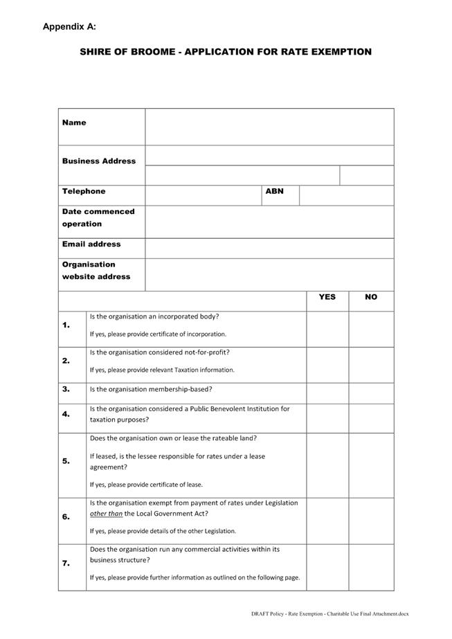
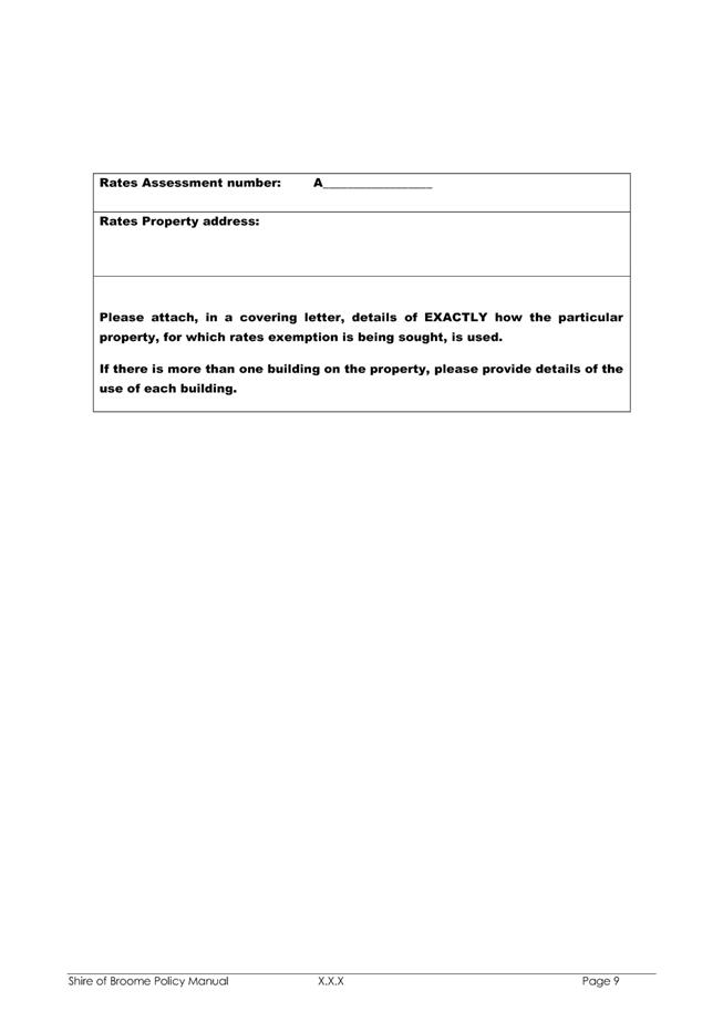
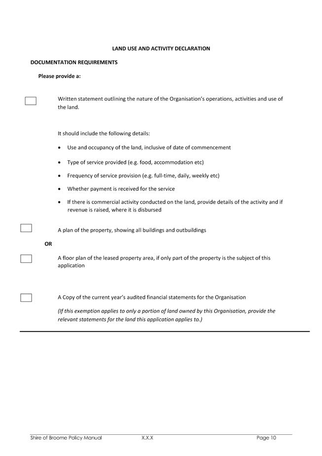
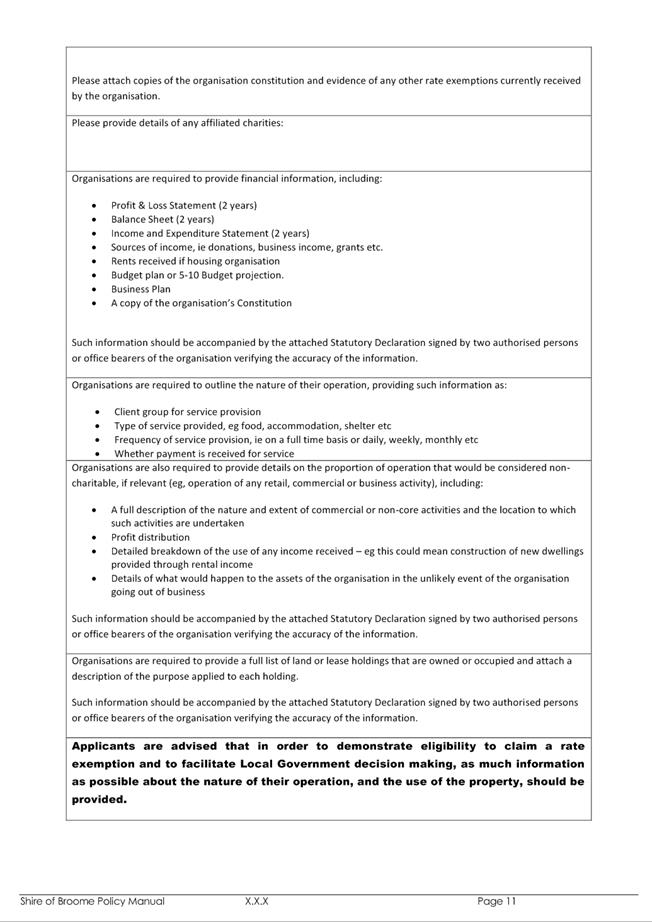
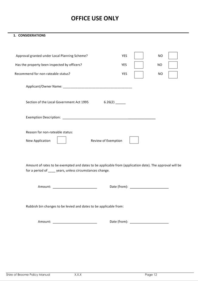
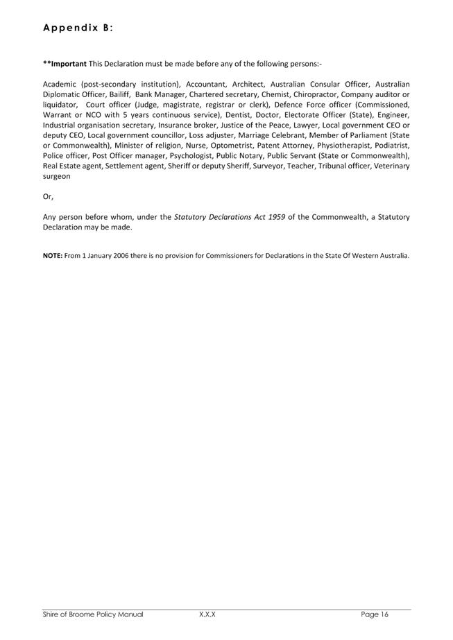
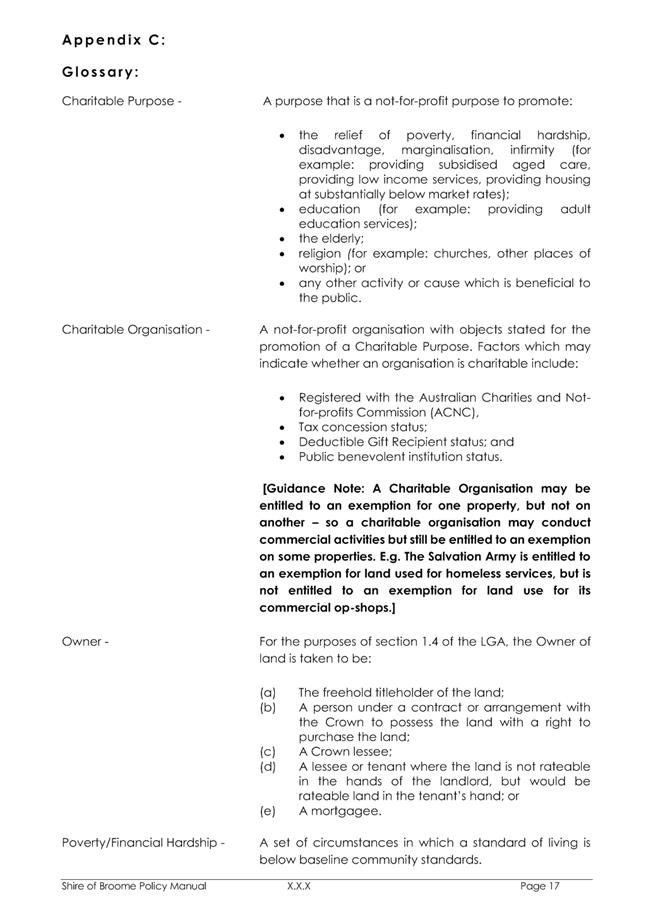
|
9.4.4 Ward and Representation
Review - Shire of Broome
LOCATION/ADDRESS: Shire
of Broome
APPLICANT: Nil
FILE: GOB03
AUTHOR: Manager
Governance
CONTRIBUTOR/S: Nil
RESPONSIBLE
OFFICER: Acting
Director Corporate Services
DISCLOSURE
OF INTEREST: Nil
DATE OF REPORT: 30
June 2016
|
|
SUMMARY:
To seek Council endorsement to undertake a Ward and Representation Review
pursuant to Schedule 2.2 of the Local Government Act 1995.
|
BACKGROUND
Previous
Considerations
OMC 19 October 1999 Item
7.3
OMC 18 July 2000 Item
7.2
OMC 24 July 2008 Item
9.1.3
OMC 20 November 2008 Item
9.1.1
Schedule 2.2 of the Local
Government Act 1995 (the Act) requires Local Governments with a Ward system
to carry out a review of the ward boundaries and the number of offices of
Councillor for each ward at least every eight years. Where a Local
Government fails to carry out a review, the Local Government Advisory Board can
recommend to the Minister that a review take place.
At the Ordinary Meeting of Council
held on 24 July 2008 Council resolved to authorise a Ward and Representation
Review prior to the October 2009 Local Government elections, and delegated the
review to the Chief Executive Officer to allow the project to proceed.
A discussion paper was made available
for public comment and it is noted that only one submission was received.
The outcome of the public consultation period for the Ward and Representation
review was presented to the Ordinary Meeting of Council held 20 November 2008,
where Council resolved to recommend to the Local Government Advisory Board that
it wished to maintain the existing ward structure with no change.
COMMENT
As the last review of ward boundaries
and representation was undertaken in 2008, in accordance with Schedule 2.2 of
the Act the Shire of Broome is now due to commence a review of its ward
boundaries and the number of offices of Councillor for each ward. Currently
the Shire of Broome has two wards, being the Broome and Dampier Wards and nine
elected members. The Broome Ward is represented by seven Councillors and
the Dampier Ward is represented by two Councillors.
The review process involves a number
of steps:
• The
Council resolves to undertake the review;
• Public
submission period opens;
• Information
provided to the community for discussion;
• Public
submission period closes;
• The
Council considers all submissions and relevant factors and makes a decision;
• The
Council submits a report to the Local Government Advisory Board (the Board) for
its consideration; and
• If
a change is proposed, the Board submits a recommendation to the Minister for Local
Government (the Minister).
Any changes approved by the Minister
will be in place for the next ordinary election where possible.
When considering changes to wards and
representation, Schedule 2.2 of the Act specifies factors that must be taken
into account by a Local Government as part of the review process:
· Community of
interest;
· Physical and
topographic features;
· Demographic
trends;
· Economic factors;
and
· Ratio of
Councillors to Electors in the various wards.
The Board offers the following
interpretation of these factors:
Community of interest
The term community of interest has a
number of elements. These include a sense of community identity and
belonging, similarities in the characteristics of the residents of a community
and similarities in the economic activities. It can also include
dependence on the shared facilities in an area as reflected in catchment areas
of local schools and sporting teams, or the circulation areas of local
newspapers.
Neighbourhoods, suburbs and towns are
important units in the physical, historical and social infrastructure and often
generate a feeling of community and belonging.
Physical and topographic features
These may be natural or man-made
features that will vary from area to area. Water features such as rivers and
catchment boundaries may be relevant considerations. Coastal plain and
foothills regions, parks and reserves may be relevant as may other man made
features such as railway lines and freeways.
Demographic trends
Several measurements of the
characteristics of human populations, such as population size, and its
distribution by age, sex, occupation and location provide important demographic
information. Current and projected population characteristics will be relevant
as well as similarities and differences between areas within the local government.
Economic factors
Economic factors can be broadly
interpreted to include any factor that reflects the character of economic
activities and resources in the area. This may include the industries
that occur in a Local Government area (or the release of land for these) and
the distribution of community assets and infrastructure such as road networks.
Ratio of Councillors to Electors
in the various wards
It is expected that each Local
Government will have similar ratios of Electors to Councillors across the wards
of its district.
Officers have prepared a draft
discussion paper titled “Shire of Broome Review of Wards and
Representation” (Attachment 1), which is based on the template provided
by the Local Government Advisory Board. The discussion paper
outlines 3 models for Council’s consideration, and recognises that
alternative recommendations may be put forward by the public.
Council is requested to approve the
release of the discussion paper and give local public notice of its intention
to carry out a review process and seek public submissions over a minimum 6 week
period.
On conclusion of the public
consultation period, and following consideration of any submissions received,
Council will then be asked to select one option to be put forward in a report
to the Local Government Advisory Board.
CONSULTATION
Officers have confirmed with the
Local Government Advisory Board that there were no proposed changes to the
publication “A Guide for Local Governments – How to conduct a
review of wards and representation for local governments with and without a
ward system” dated December 2014.
An advertisement will be placed in
the Broome Advertiser inviting members of the community of the availability of
the Shire of Broome Review of Wards and Representation discussion paper and
inviting written submissions for a minimum period of six weeks. In
accordance with Section 1.7 of the Act, notices will also be placed on the
Administration and Library Notice Boards. In addition information will be
available on the Shire of Broome website.
STATUTORY ENVIRONMENT
Local Government Act 1995
Schedule 2.2 — Provisions
about names, wards and representation
6. Local
government with wards to review periodically
(1) A
local government the district of which is divided into wards is to carry out reviews
of —
(a) its
ward boundaries; and
(b) the
number of offices of councillor for each ward,
from
time to time so that not more than 8 years elapse between successive
reviews.
(2) A
local government the district of which is not divided into wards may carry out reviews
as to —
(a) whether
or not the district should be divided into wards; and
(b) if
so —
(i) what
the ward boundaries should be; and
(ii) the
number of offices of councillor there should be for each ward,
from
time to time so that not more than 8 years elapse between successive
reviews.
(3) A
local government is to carry out a review described in subclause (1) or
(2) at any time if the Advisory Board requires the local government in
writing to do so.
[Clause 6
amended by No. 49 of 2004 s. 68(5) and (6).]
7. Reviews
(1) Before
carrying out a review a local government has to give local public notice advising —
(a) that
the review is to be carried out; and
(b) that
submissions may be made to the local government before a day fixed by the
notice, being a day that is not less than 6 weeks after the notice is first given.
(2) In
carrying out the review the local government is to consider submissions made to
it before the day fixed
by the notice.
8. Matters
to be considered in respect of wards
Before
a local government proposes that an order be made —
(a) to
do any of the matters in section 2.2(1), other than discontinuing a ward system;
or
(b) to
specify or change the number of offices of councillor for a ward,
or
proposes under clause 4(2) that a submission be rejected, its council is
to have regard, where applicable,
to —
(c) community
of interests; and
(d) physical
and topographic features; and
(e) demographic
trends; and
(f) economic
factors; and
(g) the
ratio of councillors to electors in the various wards.
[Clause 8
amended by No. 49 of 2004 s. 68(7).]
9. Proposal
by local government
On
completing a review, the local government is to make a report in writing to the
Advisory Board and may propose* to the Board the making of any order
under section 2.2(1), 2.3(3)
or 2.18(3) it thinks fit.
*
Absolute majority required.
POLICY IMPLICATIONS
Nil.
FINANCIAL IMPLICATIONS
The Review of Wards and
Representation Discussion Paper has been prepared in-house and is based on the
template provide by the Local Government Advisory Board.
The estimated cost for advertising in
the Broome Advertiser is $350.
Further financial implications may be
presented to Council when public submissions are presented following the
community consultation period. These will primarily relate to Elected
Members fees and allowances if there is a change in the number of Councillors,
and if Landgate are required to undertake any boundary changes.
RISK
The Local Government Act 1995 (the
Act) requires that each Local Government with a Ward system carry out
a review of the ward boundaries and the number of offices of Councillor for
each ward at least every eight years.
The risk is Extreme if this review is
not undertaken as it results in non-compliance with the legislative
requirements of the Act, and the Local Government Advisory Board can recommend
to the Minister that a review take place.
STRATEGIC
IMPLICATIONS
Our People
Goal – Foster a community environment that is accessible, affordable,
inclusive, healthy and safe:
Effective communication
Our
Organisation Goal – Continually enhance the Shire’s organisational
capacity to service the needs of a growing community:
An organisational culture that
strives for service excellence
Effective community engagement
Improved systems, processes and compliance
VOTING REQUIREMENTS
Simple Majority
|
REPORT
RECOMMENDATION:
That Council:
1. Endorse the
‘Shire of Broome Review of Wards and Representation Discussion
Paper’ as attached; and
2. Provide local
public notice in accordance with Clause 7(1) of Schedule 2.2 of the Local
Government Act 1995 of the intention to carry out the review and invite
submissions from the public for a period not less than 6 weeks after the
notice is first given.
|
Attachments
|
1.
|
Draft Shire of Broome
Review of Wards and Representation Discussion Paper
|
|
2.
|
Option 1 - Broome Ward
Map
|
|
3.
|
Option 1 - Dampier Ward
Map
|
|
4.
|
Option 2 - Broome Ward
Map
|
|
5.
|
Option 2 - Dampier Ward
Map
|
|
Item 9.4.4 - Ward and Representation Review - Shire of
Broome
|
Shire of
Broome Review of Wards and Representation
Discussion
Paper
1.
Background
The Shire of Broome has resolved to undertake a review of its ward system to comply with the requirements of the Local Government Act 1995 (the Act).
Schedule 2.2 of the Act requires local governments with wards to carry out reviews of the ward boundaries and the number of Councillors for each ward from time to time so that no more than eight years elapse between successive reviews.
The last review of wards in the Shire of Broome was undertaken in 2008 and it is now appropriate to carry out another review.
2.
Current situation
Currently the Shire of Broome has nine (9) Councillors elected from two (2) wards as follows:
Table: Shire of Broome elector to Councillor
ratios - current situation
|
Ward
|
Number of
Electors
|
Number of
Councillors
|
Councillor: Elector Ratio
|
% Ratio
Deviation
|
|
Broome
|
7060
|
7
|
1:1009
|
-7.80%
|
|
Dampier
|
1365
|
2
|
1:683
|
27.03%
|
|
Total
|
8426
|
9
|
1:936
|
Not
Applicable
|
(Based on
WAEC Report provided 6 April 2016 and Shire of Broome Owner/Occupier Figures at
6 April 2016)
The % ratio deviation gives a clear indication of the % difference between the average Councillor/Elector ratio for the whole local government and the Councillor/Elector ratio for each ward.
It can be seen that there is a significant imbalance in representation across the Shire with the Dampier Ward being over represented and the Broome Ward being under represented. A balanced representation would be reflected in the % ratio deviation being within plus or minus 10%.
Maps showing the ward boundaries are attached.
3.
Review process
The review process involves a number of steps:
• The council resolves to undertake the review;
• Public submission period opens;
• Information provided to the community for discussion;
• Public submission period closes;
• The Council considers all submissions and relevant factors and makes a decision;
• The Council submits a report to the Local Government Advisory
Board (the Board) for its consideration; and
• If a change is
proposed, the Board submits a recommendation to the Minister for Local
Government (the Minister).
Any changes approved by the Minister will be in place for the next ordinary election where possible.
4.
Factors to be considered
When considering changes to wards and representation, Schedule 2.2 of the Act specifies factors that must be taken into account by a local government as part of the review process:
1. Community of
interest;
2. Physical and topographic
features;
3. Demographic trends;
4. Economic factors; and
Ratio of Councillors
to Electors in the various wards.
The Board offers the following
interpretation of these factors:
1. Community of interest
The term community of interest has a number of elements. These include a sense of community identity and belonging, similarities in the characteristics of the residents of a community and similarities in the economic activities. It can also include dependence on the shared facilities in an area as reflected in catchment areas of local schools and sporting teams, or the circulation areas of local newspapers.
Neighbourhoods, suburbs and towns are important units in the physical, historical and social infrastructure and often generate a feeling of community and belonging.
2. Physical and topographic
features
These may be natural or man-made features that will vary from area to area. Water features such as rivers and catchment boundaries may be relevant considerations. Coastal plain and foothills regions, parks and reserves may be relevant as may other man-made features such as railway lines and freeways.
3. Demographic trends
Several measurements of the characteristics of human populations, such as population size, and its distribution by age, sex, occupation and location provide important demographic information. Current and projected population characteristics will be relevant as well as similarities and differences between areas within the local government.
4. Economic factors
Economic factors can be broadly interpreted to include any factor that reflects the character of economic activities and resources in the area. This may include the industries that occur in a local government area (or the release of land for these) and the distribution of community assets and infrastructure such as road networks.
5. Ratio of Councillors to Electors in the various wards
It is expected that each local government will have similar ratios of Electors to Councillors across the wards of its district. It is the
Board’s preference for the ratio between wards to fall between the plus
or minus 10% range.
5.
Options to consider
The Council will consider the following options and members of the community may suggest others:
Option 1 - Reflects the current
Ward system, which does not meet the recommended
10% variance in representation as preferred by the Local Government
Advisory Board. It is
understood that the Board recognises
that in some locations it is not always possible to achieve ratios
within plus or minus 10%.
|
Ward
|
Number of
Electors
|
Number of
Councillors
|
Councillor:
Elector Ratio
|
% Ratio
Deviation
|
|
Broome
|
7060
|
7
|
1:1009
|
-7.80%
|
|
Dampier
|
1366
|
2
|
1:683
|
27.03%
|
|
Total
|
8426
|
9
|
1:936
|
Not
Applicable
|
*************************************************
Option 2 - Involves amending the Broome Ward boundary to include
Coconut Well, 12 Mile, Skuthorpe and those electors in the Roebuck locality
that fall within the amended Broome Ward Boundary, and reducing the Dampier
Ward Councillor representation to 1. This results in a reduction in the
total number of Councillors to 8.
This achieves the recommended
10% variance in representation as preferred by the Local Government Advisory
Board.
|
Ward
|
Number of
Electors
|
Number of
Councillors
|
Councillor:
Elector Ratio
|
% Ratio
Deviation
|
|
Broome
|
7325
|
7
|
1:1046
|
.66
|
|
Dampier
|
1101
|
1
|
1:1101
|
-4.56
|
|
Total
|
8426
|
8
|
1:1053
|
Not
Applicable
|
*************************************************
Option 3 - No wards. This option
involves the dissolution of all existing ward boundaries.
With the existing nine positions of Councillor, this would provide
a ratio of 1 Councillor to 936 electors.
*************************************************
As previously indicated members of the public may suggest
other options for consideration.
To assist, the following Locality elector numbers are
provided.
|
Current Ward
|
Locality
|
# of Electors
|
|
Broome
|
Bilingurr
|
414
|
|
Broome
|
Broome
|
2213
|
|
Broome
|
Cable Beach
|
2810
|
|
Dampier
|
Dampier Peninsula
|
654
|
|
Broome
|
Djugun
|
1482
|
|
Dampier
|
Eighty Mile Beach
|
32
|
|
Dampier
|
Gingerah
|
5
|
|
Dampier
|
Lagrange
|
389
|
|
Broome
|
Minyirr
|
98
|
|
Broome
|
Roebuck (Broome Ward)
|
43
|
|
Dampier
|
Roebuck (Dampier Ward)
|
206
|
|
Dampier
|
Waterbank
|
80
|
|
|
TOTAL
|
8426
|
The attached maps indicate the current Wards and
localities within each Ward.
As provided in the
options, also under consideration will be the number of Councillors for each ward and the district. For example, it may be that fewer Councillors will provide good representation and may result in financial savings and more effective and efficient decision making.
6.
Public submissions
Members of the community are invited to make a written submission about any aspect of ward boundaries and representation.
A submission form is
provided at the end of this document for your convenience. You do not
have to use this form for your written public submission.
Your written
submission should be addressed to the Chief Executive Officer and clearly
marked “Ward and Representation Review” and can be lodged by any of the following
methods:
Hand deliver to: Shire of Broome
Cnr Weld and Haas Streets
BROOME WA 6725
Post to: Shire
of Broome
PO Box
44
BROOME WA 6725
Fax
to: 08
9191 3455
Email to: shire@broome.wa.gov.au
All submissions must be received by 4pm on [Insert date]
Thank you for your interest and involvement in this review. Council welcomes your comments on any matters that may assist it to make informed and responsible decisions for the benefit of the people of the Shire of Broome.
Cr R J Johnston KR
Donohoe
Shire President Chief
Executive Officer
|
Item 9.4.4 - Ward and Representation Review - Shire of
Broome
|
PUBLIC
SUBMISSION PRO FORMA
SHIRE OF BROOME
REVIEW OF CURRENT WARD BOUNDARIES AND THE NUMBER OF
OFFICES OF COUNCILLOR 2016
Note:
This form is provided for your convenience. Written public
submissions do not have to be made on this form.
To: Chief Executive Officer
Shire
of Broome
PO
Box 44
BROOME
WA 6725
Email:
shire@broome.wa.gov.au
Fax: (08)
9191 3455
I
support the following Ward Boundary/ number of Offices of Councillor:
Option
1: Retain
existing 2 Ward System – 9 Councillors (7 Broome Ward – 2 Dampier
Ward)
Yes No
Or
Option
2: Amend the Broome Ward boundary to
include Coconut Well, 12 Mile, 16 Mile and those electors in the Roebuck
locality that fall within the proposed amended Broome Ward Boundary. In
addition reduce the Dampier Ward Councillor representation to 1, resulting in a
total of 8 Councillors. (7 Broome Ward – 1 Dampier Ward)
Yes No
Or
Option 3: Introduce a no-ward system – 9
Elected Members
Yes No
Or
I propose
the following Ward boundary/Councillor structure:
The Shire of
Broome should have …………….. Wards and
…………………. Councillors.
The
Shire’s Wards should have the following names and number of Councillors:
Name No
of Councillors
Ward 1
……………………………………………
……………………………………………………………………………
Ward 2
……………………………………………
……………………………………………………………………………
Ward 3
……………………………………………
……………………………………………………………………………
Ward 4
……………………………………………
……………………………………………………………………………
Ward 5
……………………………………………
……………………………………………………………………………
The
Shire’s Wards should contain the following suburbs/localities and/or
physical/topographic features:
Ward 1
……………………………………………………………………………………………………………………………………………
Ward 2
……………………………………………………………………………………………………………………………………………
Ward 3
……………………………………………………………………………………………………………………………………………
Ward 4
……………………………………………………………………………………………………………………………………………
Ward 5
……………………………………………………………………………………………………………………………………………
_______________________________________________________________
Comments
in support of my preferred option:
…………………………………………………………………………………………………………………………………………………….
…………………………………………………………………………………………………………………………………………………….
…………………………………………………………………………………………………………………………………………………….
…………………………………………………………………………………………………………………………………………………….
…………………………………………………………………………………………………………………………………………………….
…………………………………………………………………………………………………………………………………………………….
…………………………………………………………………………………………………………………………………………………….
…………………………………………………………………………………………………………………………………………………….
Submitted
by:
Name: ……………………………………………………………………….
Address:
……………………………………………………………………….
Contact
details: ……………………………………………………………………….
The Shire of Broome
thanks you for your submission.
|
Item 9.4.4 - Ward and Representation Review - Shire of
Broome
|
|
Item 9.4.4 - Ward and Representation Review - Shire of Broome
|
|
Item 9.4.4 - Ward and Representation Review - Shire of Broome
|
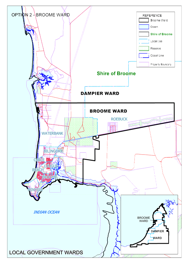
|
Item 9.4.4 - Ward and Representation Review - Shire of Broome
|

|
9.4.5 BROOME REGIONAL RESOURCE
RECOVERY PARK - LICENCE TO OCCUPY CROWN LAND
LOCATION/ADDRESS: UCL
LOT 259 ON DEPOSITED PLAN 220696
APPLICANT: N/A
FILE: RRP01
AUTHOR: Waste
Coordinator
CONTRIBUTOR/S: Nil
RESPONSIBLE
OFFICER: Deputy
Chief Executive Officer/Director Community & Economic Development
DISCLOSURE
OF INTEREST: NIL
DATE OF REPORT: 13
July 2016
|
|
SUMMARY:
The Department of Lands will grant the Shire of Broome a licence to
occupy Site A1 situated on UCL Lot 259 on Deposited Plan 220696 for the
purpose of environmental assessments associated with the Regional Resource
Recovery Park. This report recommends that the Shire President and
Chief Executive Officer are authorised to engross the Licence document.
|
BACKGROUND
Previous
Considerations
OMC 10 July 2010 Item
9.3.14
OMC 7 July 2011 Item
9.3.2
OMC 15 March 2012 Item
9.2.9
OMC 29 November 2012 Item
9.3.2
OMC 21 February 2013 Item
9.3.1
OMC 17 October 2013 Item
9.3.1
OMC 25 September 2014 Item
9.3.1
OMC 30 July 2015 Item
9.2.5
SMC 10 September 2015 Item
6.2.2
SMC 19 January 2016 Item
6.1.3
OMC 31 March 2016 Item
9.1.1
At the Ordinary Meeting of Council
held 31 March 2016 Council authorised the Chief Executive Officer to apply to
the Department of Lands (DoL) for a Licence to undertake the required site
investigations on Site A1 situated on UCL Lot 259 on Deposited Plan 220696 (see
attachment).
COMMENT
To ensure that Site A1 is suitable
for the development of the Regional Resource Recovery Park (RRRP) detailed site
investigations must be carried out. The detailed site investigations seek
to confirm the groundwater, flora and fauna characteristics of Site A1. The
detailed site investigations will require the installation of up to four
kilometres of access tracks off the Broome Cape Leveque Road and the
installation of five groundwater monitoring bores.
Site A1 is unallocated crown land and
is the subject of two Native Title applications (Jabirr Jabirr and
Goolarabooloo). It is noted that the State is considering these
applications as part of a wider process involving Native Title across the
Dampier Peninsula. DoL received advice from the Department of Premier and
Cabinet that the status of the Native Title considerations is ongoing and will
not be determined until early 2017.
Considering this advice, the licence
to occupy crown land is provided up to 6 February 2017. At this point,
the Shire may need to negotiate further access with the determined Native Title
holder.
It is envisaged that the detailed
site investigations on Site A1 will begin in August 2016 with the pre wet
season assessments for groundwater, flora and fauna. Further groundwater
and vegetation assessments are required following the wet season which fall
outside the proposed licence period. Access to the land for these
investigations will need to be negotiated with DoL or the determined Native
Title holder dependant on the status of the Native Title considerations on the
licence expiry date.
Following the detailed site
investigations a report will be provided back to Council on the results of the
investigations. At this point officers may also seek endorsement of a
preferred site to carry forward to the required approvals stage.
CONSULTATION
The Licence application to the DoL
was made on 8 April 2016.
On 4 May 2016 following the DoL
review of the Shire application a ‘preliminary’ 30 day referral
period was commenced in accordance with s91 Land Administration Act 1997 and
s24LA Native Title Act 1993 (Commonwealth). Immediately following the
preliminary referral period DoL commenced the ‘legislated’ 30 day
referral period. This two stage approach is undertaken to provide
traditional owners sufficient time to provide their comments.
On 7 July 2016 DoL advised they will
grant the licence in favour of the Shire of Broome.
STATUTORY ENVIRONMENT
Land Administration Act 1997
Part 6 Sales,
leases, licences, etc. of Crown land
Division 4 Provisions not
restricted to either sale or leasing of Crown land
91. Licences
and profits à prendre over Crown land, grant of
(1) The
Minister may grant a licence or profit à prendre in respect of Crown
land for any purpose.
(2) The
Minister may —
(a) fix
or extend the duration of; or
(b) determine
fees and conditions in respect of; or
(c) review;
or
(d) with
the consent of its holder, amend the provisions of, any licence or profit
à prendre granted under subsection (1).
(3) The
Minister may on the breach of any condition to which a licence granted under
subsection (1) is subject, terminate that licence.
(4) The
Minister may accept the surrender of a profit à prendre granted under
subsection (1) from its holder in respect of the whole or any part of the
area to which that profit à prendre applies.
(5) Nothing
in this Act prevents the simultaneous existence on the same area of Crown land
of —
(a) a
licence or profit à prendre granted under subsection (1); and
(b) a
mining, petroleum or geothermal energy right,
if the Minister to
whom the administration of the relevant Act referred to in the definition of
mining, petroleum or geothermal energy right in section 3(1) is for the
time being committed by the Governor, or a public service officer of the
department that is principally assisting in the administration of the relevant
Act, who is authorised in writing by that Minister to do so, approves of that
area being used both for the purposes of that licence or profit à
prendre and the purposes of the mining, petroleum or geothermal energy right.
(6) If
a licence granted under subsection (1) is transferable by the licensee, in
accordance with the Personal Property Securities Act 2009 (Commonwealth)
section 10 the definition of licence paragraph (d), the licence is
declared not to be personal property for the purposes of that Act.
Native Title Act 1993
(Commonwealth)
Part 2 Native
Title
Division 2 Future
acts etc. and native title
Subdivision L Low
impact future acts
24LA Low impact future acts
(1) This
Subdivision applies to a future act in relation to particular land or waters
if:
(a) the
act takes place before, and does not continue after, an approved determination
of native title is made in relation to the land or waters, if the determination
is that native title exists; and
(b) the
act does not consist of, authorise or otherwise involve:
(i) the
grant of a freehold estate in any of the land or waters; or
(ii) the
grant of a lease over any of the land or waters; or
(iii) the
conferral of a right of exclusive possession over any of the land or waters; or
(iv) the
excavation or clearing of any of the land or waters; or
(v) mining
(other than fossicking by using hand‑held implements); or
(vi) the
construction or placing on the land, or in the waters, of any building,
structure, or other thing (other than fencing or a gate), that is a fixture; or
(vii) the
disposal or storing, on the land or in the waters, of any garbage or any
poisonous, toxic or hazardous substance.
Exclusion for public health or
safety etc.
(2) Subparagraph (1)(b)(iv)
does not apply to:
(a) excavation
or clearing that is reasonably necessary for the protection of public health or
public safety; or
(b) tree
lopping, clearing of noxious or introduced animal or plant species, foreshore
reclamation, regeneration or environmental assessment or protection activities.
Validation of act
(3) If this
Subdivision applies to a future act, the act is valid.
Non‑extinguishment
(4) The non‑extinguishment
principle applies to the act.
POLICY IMPLICATIONS
Nil
FINANCIAL IMPLICATIONS
The licence and documentation
preparation fee payable to DoL is $685.00 including GST. This fee and the
operational expenditure required to undertake detailed site investigations is
approved for in the 2016/17 budget account 101080010 New Refuse Site Exp - Op
Exp - Regional Resource Recovery Park MUN.
RISK
Site A1 is currently subject to
Native Title considerations. Should Native Title be determined to exist
with any of the current claimants the Licence would become invalid.
Advice from the Department of Premier and Cabinet is that the status of the
Native Title considerations is ongoing and will not be determined until early
2017. The proposed licence expires on 6 February 2017.
The expiry date will allow the Shire
to complete the pre wet season groundwater, flora and fauna assessments but
prevents the completion of the post wet season groundwater and vegetation
surveys. Post wet season bore sampling and vegetation surveys are seen as
a minimum requirement for the completion of the detailed site investigations.
The potential impact of Native Title
being determined for Site A1 prior to detailed site investigations being
completed is “Major”. The likelihood of this occurring is
determined as ‘possible’, which still results in an overall risk
rating of ‘extreme’.
If Native Title was determined prior
to site investigations being complete, the Shire would be required to negotiate
access to Site A1 with the determined Native Title holder. The
negotiations for access would be similar in nature to the negotiations
currently underway with Yawuru for access to Site G1. These negotiations
would see agreements entered into which allow access to the land for detailed
site investigations and then following successful outcomes from the detailed
site investigations, potentially an Indigenous Land Use Agreement for use of
the site as a RRRP.
If Native Title was not determined by
6 February 2017 the Shire could apply to DoL for a new Licence to occupy the
crown land. Depending on the delay to the Native Title considerations this may
allow for the post wet season site investigations to occur.
The outcomes of the Native Title
determination are an unknown factor and can be seen as a risk for the Shire.
The Shire is unaware who it may be dealing with and whether a RRRP on Site A1
is supported. The Native Title holders approach to negotiations and their
overall willingness to work within the Shire’s tight timeframes to
achieve delivery on the RRRP is currently unknown. Early liaison with the
claimants may reduce the risk of delays if Native Title is determined.
Any delay in development of the RRRP
poses a significant risk as the Buckleys Road Waste Management Facility is
rapidly approaching the end of its operational life. If the facility
reaches capacity and the RRRP is not yet operational, then waste will need to
be transported to the nearest suitable landfill (Port Hedland). Based on
2014 waste tonnages, it is estimated that annual cost to transport waste to
Port Hedland is approximately $7M. This equates to an increase in tipping
fees of approximately 400% and kerbside collection fees of approximately 210%.
The financial consequence of the RRRP
not being operational before all the airspace is consumed at the Buckleys Rd
Facility is determined to be ‘catastrophic’. The likelihood
of the RRRP not being operational is determined as ‘unlikely’,
which still results in an overall risk rating of ‘extreme’.
The progressing of site investigations will reduce this risk to the
Shire.
STRATEGIC
IMPLICATIONS
Our People
Goal – Foster a community environment that is accessible, affordable,
inclusive, healthy and safe:
Effective communication
Affordable services and initiatives
to satisfy community need
A healthy and safe environment
Our Place
Goal – Help to protect the nature and built environment and cultural
heritage of Broome whilst recognising the unique sense of the place:
A unique natural environment for the
benefit and enjoyment of current and future generations
Core asset management to optimise
Shire’s infrastructure whilst minimising life cycle costs.
Our
Prosperity Goal – Create the means to enable local jobs creation and
lifestyle affordability for the current and future population:
Affordable and equitable services and
infrastructure
Our
Organisation Goal – Continually enhance the Shire’s organisational
capacity to service the needs of a growing community:
Effective community engagement
Improved systems, processes and
compliance
VOTING REQUIREMENTS
Simple Majority
|
REPORT
RECOMMENDATION:
That Council:
1. Authorises
the Shire President and Chief Executive Officer to engross the Licence to
Occupy Crown Land 00303/2016_A5726334;
2. Requests
the Chief Executive Officer to initiate discussions with the current
claimants over Site A1 to inform them of the Shire’s approach and
aspirations for the project; and
3. Authorises
the Shire President and Chief Executive Officer to engross a new Licence to
occupy crown land if the Native Title considerations are not determined by 6
February 2017.
|
Attachments
|
1.
|
Licence to Occupy Crown
Land 00303/2016_A5726334
|
|
Item 9.4.5 - BROOME REGIONAL RESOURCE RECOVERY PARK -
LICENCE TO OCCUPY CROWN LAND
|


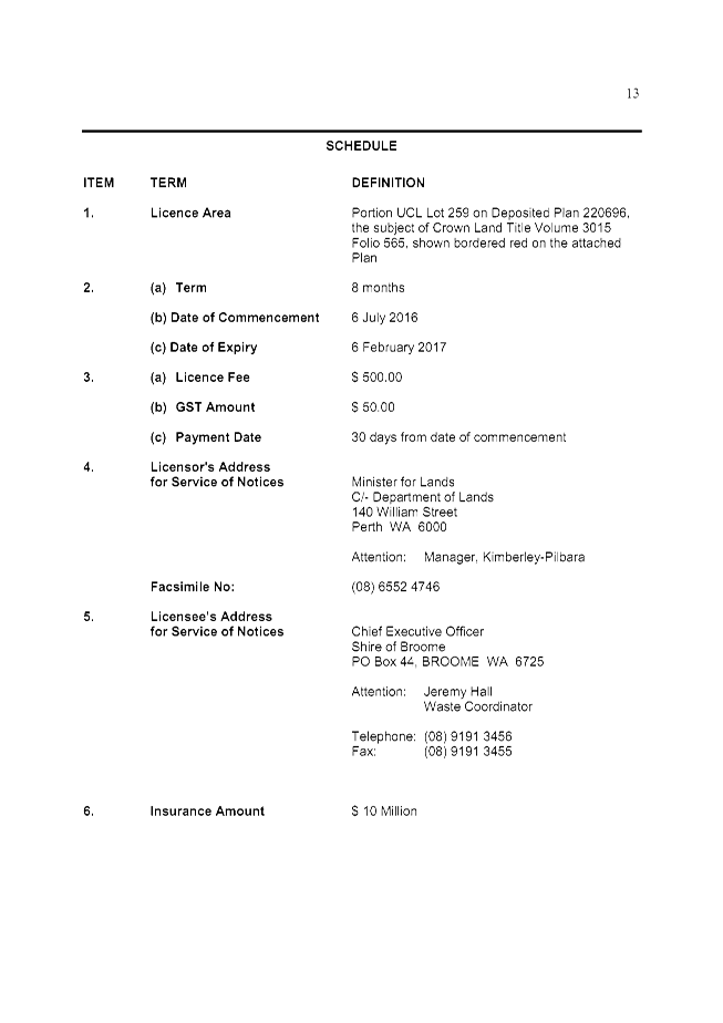

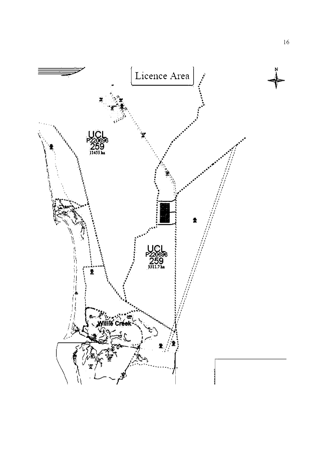
Agenda – Ordinary Meeting of
Council 28 July 2016 Page
829 of 830
This
item and any attachments are confidential in accordance with Section 5.23(2) of
the Local Government Act 1995 section 5.23(2)((e)(iii)) as it contains “a
matter that if disclosed, would reveal information about the business,
professional, commercial or financial affairs of a person, where the
information is held by, or is about, a person other than the local
government”, and section 5.23(2)(d) as it contains “legal advice
obtained, or which may be obtained, by the local government and which relates
to a matter to be discussed at the meeting”.
|
SUMMARY: Kimberley
Land Council Aboriginal Corporation (ICN 21) (KLC) has submitted an objection
to the rate record under Section 6.76(1)(a)(ii) of the Local Government
Act (LGA) in relation to land nominated as Assessment A108560 (the
Property) for the 2015/2016 financial year on the basis that the land is not
rateable under Section 6.26(2)(g) of the LGA, which applies where the
land is used exclusively for charitable purposes (Charitable Use Exemption).
This report recommends that Council allows the objection.
|
Attachments
|
1.
|
ATTACHMENT 1
KLC’s Application for Rate Exemption received by the Shire 16 July 2015
(Confidential to Councillors and Directors Only)
This attachment is confidential in accordance with
Section 5.23(2) of the Local Government Act 1995 section 5.23(2)((e)(iii)) as
it contains “a matter that if disclosed, would reveal information
about the business, professional, commercial or financial affairs of a
person, where the information is held by, or is about, a person other than
the local government”.
|
|
2.
|
ATTACHMENT 2 WALGA
guidelines 21 July 2015: Rates and Charitable Land Use Exemption Applications
|
|
3.
|
ATTACHMENT 3 Report to
Council at the OMC held 2 September 2009 in relation to previous application
for Charitable Use Exemption (Confidential to Councillors and Directors
Only)
This attachment is confidential in accordance with
Section 5.23(2) of the Local Government Act 1995 section 5.23(2)((e)(iii)) as
it contains “a matter that if disclosed, would reveal information
about the business, professional, commercial or financial affairs of a
person, where the information is held by, or is about, a person other than
the local government”.
|
|
4.
|
ATTACHMENT 4 Copies of
funding agreements provided by the KLC to the Shire 19 October 2015
(Confidential to Councillors and Directors Only)
This attachment is confidential in accordance with
Section 5.23(2) of the Local Government Act 1995 section 5.23(2)((e)(iii)) as
it contains “a matter that if disclosed, would reveal information
about the business, professional, commercial or financial affairs of a
person, where the information is held by, or is about, a person other than
the local government”.
|
|
5.
|
ATTACHMENT 5 Additional
documents provided by the KLC to the Shire 12 May 2016 (Confidential to
Councillors and Directors Only)
This attachment is confidential in accordance with
Section 5.23(2) of the Local Government Act 1995 section 5.23(2)((e)(iii)) as
it contains “a matter that if disclosed, would reveal information
about the business, professional, commercial or financial affairs of a person,
where the information is held by, or is about, a person other than the local
government”.
|
|
6.
|
ATTACHMENT 6 Legal
advice to the Shire dated 24 October 2014 (Confidential to Councillors and
Directors Only)
This attachment is confidential in accordance with
Section 5.23(2) of the Local Government Act 1995 section 5.23(2)(d) as it
contains “legal advice obtained, or which may be obtained, by the local
government and which relates to a matter to be discussed at the meeting”.
|
|
7.
|
ATTACHMENT 7 Legal
advice to the Shire dated 24 June 2016 (Confidential to Councillors and
Directors Only)
This attachment is confidential in accordance with
Section 5.23(2) of the Local Government Act 1995 section 5.23(2)(d) as it
contains “legal advice obtained, or which may be obtained, by the local
government and which relates to a matter to be discussed at the meeting”.
|
10.
REPORTS
OF
COMMITTEES
|
10.1 APPOINTMENT OF
MEMBERS TO THE ECONOMIC DEVELOPMENT ADVISORY COMMITTEE
LOCATION/ADDRESS: Nil
APPLICANT: Nil
FILE: EDP002
AUTHOR: Administration
Officer - Community and Economic Development
CONTRIBUTOR/S: Nil
RESPONSIBLE
OFFICER: Deputy
Chief Executive Officer/Director Community & Economic Development
DISCLOSURE
OF INTEREST: Nil
DATE OF REPORT: 14
June 2016
|
|
SUMMARY: This
report presents expressions of interest for membership to the Economic
Development Advisory Committee including a delegate for a proposed additional
member position of ‘Industry Representatives
Deputy Delegate for Land Development Industry’ representation.
Officers seek Council’s appointment of members and the
additional deputy position to the Committee in accordance with the Terms of
Reference.
This report also requests minor updates to the Terms of
Reference to include the proposed additional member position and newly
appointed members to existing member positions.
|
BACKGROUND
Previous
Considerations
OMC 23 October 2014 Item
10.3
OMC 30 April 2015 Item
10.2
OMC 26 November 2015 Item
9.4.5 (Appointments to Committees)
COMMENT
Established by
Shire of Broome in accordance with Council resolution on 30 April 2015, the Economic Development Advisory Committee’s purpose
is to provide advice to the Shire of Broome on Economic Development matters
including but not limited to:
1. Provide advice and
guidance to the Shire and other partners in positioning local businesses and
industry to capitalise on global and emerging industry trends that facilitate
new markets and investment.
2. Assist in the
formulation of stakeholders, strategic partnerships and communication to
facilitate new and developing industry initiatives across sectors to ensure
ongoing and sustained economic growth.
3. Provide guidance and
advice on the role the Council should play to address industry specific feedback
(including perceived impediments) on State, Local and Federal regulatory
processes and funding programs to create better investment conditions and
refinements for economic growth and employment generation in the short, medium
and long term.
4. Provide advice to
the Shire of Broome to facilitate identified industry and strategic initiatives
across industry sectors and relevant organisations.
5. Provide industry
feedback and input as appropriate into strategic and high-level economic
development documents/plans including future growth plans for Broome, including
but not limited to, the Kimberley Regional Investment Blueprint and Kimberley
Planning and Infrastructure Framework.
6. Provide advice to
Council on policies relating to Economic Development as required.
This report requests that Council considers the matter of
committee membership of the Economic Development Advisory Committee
(EDAC). The following appointments are recommended as per the
Expressions of Interest (EOI) contained in the
confidential attachment to this report:
· A letter of resignation has been received from Educational
Institution delegate Karen Dickinson (North Regional TAFE; previously Kimberley
Training Institute). An expression of interest (EOI) has been received
for this position. It is recommended that Council accepts this EOI and
appoints this community member to the EDAC as an Educational Institution
delegate for North Regional TAFE representation.
· A letter of resignation has been received from Educational
Institution delegate Julie Kean (North Regional TAFE; previously Kimberley
Training Institute), deputy for Karen Dickinson. An expression of
interest (EOI) has been received for this position. It is recommended
that Council accepts this EOI and appoints this community member to the EDAC as
an Educational Institution deputy delegate for North Regional TAFE
representation.
· A letter of resignation has been received from Business
Associations delegate Gail Gower, deputy for James Brown (Tourism
Industry). An expression of interest (EOI) has been received for this
position. It is recommended that Council accepts this EOI and appoints
this community member to the EDAC as a Business Associations deputy delegate
for Tourism Industry representation.
· A letter of resignation has been received from Business
Associations delegate Rhondda Chappell (Broome Chamber of Commerce). An
expression of interest (EOI) has been received for this position. It is
recommended that Council accepts this EOI and appoints this community member to
the EDAC as a Business Associations delegate for Broome Chamber of Commerce
representation.
· A letter of resignation has been received from Industry
Representatives delegate Dean Newton (Land Development Industry). An
expression of interest (EOI) has been received for this position. It is
recommended that Council accepts this EOI and appoints this community member to
the EDAC as an Industry Representatives delegate for Land Development Industry
representation.
· An expression of interest (EOI) has been received for a
deputy Land Development Industry position. This is a new position within the
EDAC and should Council choose to appoint a deputy Land Development Industry,
the terms of reference will be updated accordingly. It is recommended that
Council accepts this EOI and appoints this community member to the EDAC as an
Industry Representatives deputy delegate for Land Development Industry
representation.
The terms of Reference for all
Committees were presented to Council at the 26 November 2015 OMC. To ensure
ongoing participation of members of the EDAC and continued continuity and
collaboration of EDAC activity across key organisations, industry and
Government; Officers propose that Council formally approves the appointment of
these five (5) delegates to fill existing vacant member positions as well as
the appointment of a delegate to the proposed additional member position of Industry Representatives deputy delegate for Land
Development Industry representation to the EDAC within the Terms of Reference,
noting that all other aspects of the terms of reference remain the same.
CONSULTATION
Officers sought
expressions of interest (EOI) from existing member organisations for
replacement delegates.
In addition, an EOI was received for a
deputy to the Land Development delegate to be appointed. While there are
deputies appointed for most positions on the EDAC, a deputy has not previously
been appointed for the Land Development delegate. Officers recommend that the
deputy land delegate is appointed.
STATUTORY ENVIRONMENT
5.10. Committee
members, appointment of
(1) A
committee is to have as its members —
(a) persons
appointed* by the local government to be members of the committee (other than
those referred to in paragraph (b)); and
(b) persons
who are appointed to be members of the committee under subsection (4) or
(5).
* Absolute
majority required.
(2) At
any given time each council member is entitled to be a member of at least one
committee referred to in section 5.9(2)(a) or (b) and if a council member
nominates himself or herself to be a member of such a committee or committees,
the local government is to include that council member in the persons appointed
under subsection (1)(a) to at least one of those committees as the local
government decides.
(3) Section 52
of the Interpretation Act 1984 applies to appointments of committee
members other than those appointed under subsection (4) or (5) but any
power exercised under section 52(1) of that Act can only be exercised on
the decision of an absolute majority of the local government.
(4) If
at a meeting of the council a local government is to make an appointment to a
committee that has or could have a council member as a member and the mayor or
president informs the local government of his or her wish to be a member of the
committee, the local government is to appoint the mayor or president to be a
member of the committee.
(5) If
at a meeting of the council a local government is to make an appointment to a
committee that has or will have an employee as a member and the CEO informs the
local government of his or her wish —
(a) to
be a member of the committee; or
(b) that
a representative of the CEO be a member of the committee,
the
local government is to appoint the CEO or the CEO’s representative, as
the case may be, to be a member of the committee.
5.11A. Deputy
committee members
(1) The
local government may appoint* a person to be a deputy of a member of a
committee and may terminate such an appointment* at any time.
* Absolute
majority required.
(2) A
person who is appointed as a deputy of a member of a committee is to
be —
(a) if
the member of the committee is a council member — a council member;
or
(b) if
the member of the committee is an employee — an employee; or
(c) if
the member of the committee is not a council member or an employee —
a person who is not a council member or an employee; or
(d) if
the member of the committee is a person appointed under
section 5.10(5) — a person nominated by the CEO.
(3) A deputy of a member of a committee may perform
the functions of the member when the member is unable to do so by reason of
illness, absence or other cause.
(4) A deputy of a member of a committee, while acting
as a member, has all the functions of and all the protection given to a member.
[Section 5.11A
inserted by No. 17 of 2009 s. 20.]
5.11. Committee
membership, tenure of
(1) Where
a person is appointed as a member of a committee under section 5.10(4) or
(5), the person’s membership of the committee continues until —
(a) the
person no longer holds the office by virtue of which the person became a
member, or is no longer the CEO, or the CEO’s representative, as the case
may be; or
(b) the
person resigns from membership of the committee; or
(c) the
committee is disbanded; or
(d) the
next ordinary elections day,
whichever
happens first.
(2) Where
a person is appointed as a member of a committee other than under
section 5.10(4) or (5), the person’s membership of the committee
continues until —
(a) the
term of the person’s appointment as a committee member expires; or
(b) the
local government removes the person from the office of committee member or the
office of committee member otherwise becomes vacant; or
(c) the
committee is disbanded; or
(d) the
next ordinary elections day,
whichever
happens first.
POLICY IMPLICATIONS
Nil
FINANCIAL IMPLICATIONS
Nil
RISK
Nil
STRATEGIC
IMPLICATIONS
Our People
Goal – Foster a community environment that is accessible, affordable,
inclusive, healthy and safe:
Effective communication
Affordable services and initiatives
to satisfy community need
Our
Prosperity Goal – Create the means to enable local jobs creation and
lifestyle affordability for the current and future population:
Key economic development strategies
for the Shire which are aligned to regional outcomes working through recognised
planning and development groups/committees
Our
Organisation Goal – Continually enhance the Shire’s organisational
capacity to service the needs of a growing community:
An organisational culture that
strives for service excellence
Effective community engagement
VOTING REQUIREMENTS
Absolute Majority
|
REPORT
RECOMMENDATION:
That Council:
1. Adopts a new deputy Land Development Industry member
position within the Economic Development Advisory Committee and appoint
member as per the Expression of
Interest contained in the confidential attachment to this report;
2. Appoints members in accordance with the Terms of
Reference to the Economic Development Advisory Committee as per the Expressions of Interests contained in the
confidential attachment to this report;
3. Requests
the Chief Executive Officer to update the Terms of Reference to reflect the
newly created deputy Land Development
Industry position and newly appointed committee members.
(Absolute Majority Required)
|
Attachments
|
1.
|
Confidential Attachment
- EOI's 110716 (Confidential to Councillors and Directors Only)
This attachment is confidential in accordance with
Section 5.23(2) of the Local Government Act 1995 section 5.23(2)((e)(iii)) as
it contains “a matter that if disclosed, would reveal information
about the business, professional, commercial or financial affairs of a
person, where the information is held by, or is about, a person other than
the local government”.
|
|
10.2 Yawuru Park Council
Progress Report, 2015 Minutes (March, May and July) and 2016 Minutes
(February)
LOCATION/ADDRESS: Joint
Managed Lands - Yawuru Indigenous Land Use Agreements
APPLICANT: Nil
FILE: NAT
55; NAT 55.1; NAT 55.2; 55.3; NAT 55.3; NAT 55.5 and NAT 55.6
AUTHOR: Coastal
Park Governance Officer
CONTRIBUTOR/S: Nil
RESPONSIBLE
OFFICER: Director
Development Services
DISCLOSURE
OF INTEREST: Nil
DATE OF REPORT: 11
July 2016
|
|
SUMMARY: This
report presents Council with a progress report for the Yawuru Park Council (YPC),
including the Confirmed Minutes and associated Recommendations of the YPC for
the months March 2015, May 2015, July 2015 and February 2016. This report
also provides Council with the agreed Terms of Reference for the Senior
Officers Group.
|
BACKGROUND
Previous
Considerations
OMC 26 November 2015 Item
9.2.4
OMC 25 June 2015 Item
10.4
OMC 27 November 2014 Item
10.2
SMC 29 May 2013 Item
9.2.1
OMC 15 March 2012 Item
9.2.5
The Yawuru Park Council (YPC)
has been formed in accordance with the two Yawuru Indigenous Land Use
Agreements (ILUAs) and is comprised of Yawuru Registered Native Title
Body Corporate/Nyamba Buru Yawuru Representatives (Yawuru), delegates
from the Department of Parks and Wildlife (DPaW) and Shire of Broome
representatives. Through the YPC, these three organisations are responsible for
jointly managing land within the Yawuru Conservation Estate in accordance with
the ILUAs.
The following
table outlines the four land/sea management areas within the Conservation
Estate, including the bodies with direct management responsibility for each
area:
|
Conservation Estate Area
|
Management responsibility
|
|
Minyirr Buru (Townsite Areas)
|
Yawuru and the Shire
|
|
Cable Beach Intertidal Zone (located approximately 600
meters north of the rocks at Cable Beach) (Intertidal Zone)
|
Yawuru, the Shire and DPaW
|
|
Birragun (Out of town Areas)
|
Yawuru and DPaW
|
|
Nagulagun (Marine Park Areas)
|
Yawuru and DPaW
|
The following are
the current representatives on the YPC:
Yawuru
Representatives: Debra
Pigram (Chair), Maxine Charlie and Dean Mathews.
Yawuru
Proxies: Michael
Corpus, Susan Edgar and Darren Puertollano.
Shire
Representatives: Cr
Harold Tracey and Kenn Donohoe.
Shire
Proxies: Cr
Ron Johnston and Cr Chris Mitchell.
DPaW
Representatives: Alan
Byrne, Darren Stevens and James Dobson.
DPaW Proxies: Anthony
Richardson and Luke Puertollano
The Shire’s Policy 1.5.1 Yawuru
Park Council Representation does not provide the Shire’s YPC
Representatives with the ability to make decisions on the YPC that bind
Council. Therefore, Council must endorse
motions passed at all YPC meetings.
Yawuru Park Council minutes were last
presented to the Shire of Broome for endorsement at the Ordinary Meeting of
Council (OMC) on 25 June 2015 which included minutes for the YPC
meetings held on 13 August 2014 and 22 September 2014.
COMMENT
Background
Since the meeting
on 22 September 2014, the YPC have met on the following dates:
· 18
March 2015 (confirmed minutes shown in Attachment 1).
· 13
May 2015 (confirmed minutes shown in Attachment 2).
· 15
July 2015 (confirmed minutes shown in Attachment 3).
· 25
February 2016 (unconfirmed minutes shown in Attachment 4 – minutes were
confirmed at the meeting on 7 July 2016, however a confirmed copy of the
minutes have not yet been provided).
To ensure that
YPC initiatives were progressing and to provide senior leadership and direction
to the YPC Working Group, the Shire’s Chief Executive Officer initiated
the formation of the YPC Senior Officers Group (SOG). The SOG meets as
required to progress projects. The formation of this group was formally agreed
by the YPC at its meeting on 15 July 2015, and the terms of reference for this
Group is provided in Attachment 5 to this report.
YPC Minutes
The minutes of the YPC meeting held
18 March 2015 are attached (Attachment 1). At the meeting, the YPC
considered the following items:
Item 5.1 Recreation Master Plan Update
|
RECOMMENDATION:
That the YPC notes the current Recreation Master Plan and
ensures that organisational staff attend and participate in workshop planned
for 20-3-2015.
Moved: Alan Byrne
Seconded: Graeme Campbell
|
Item 5.2 Fire planning and land assemblage
|
RECOMMENDATION:
Yawuru and SOB meet to address
the issues identified in the “issues paper” to inform the Senior
Officers Group (SOG) of a way forward.
Moved:
Graeme
Campbell
Seconded: Dean Matthews
|
Item: 5.3 S.O.G – Role of the body
|
RECOMMENDATION:
The YPC approves the formation of the Senior Officers
Group (SOG).
Moved: Dean Matthews Seconded: Graeme Campbell
|
Item: 5.4 YPC/JMB Division
|
RECOMMENDATION:
1. The YPC
Secretariat to provide further information on the impacts of a new ILUA to
the Joint Management Partners prior to progressing the drafting of a new
ILUA. The Information Brief should include (but not be limited to) the
following:
a) Overview regarding the impacts on the
two current ILUAs – will a third ILUA negates the original two?
ie. If a new ILUA is put in place; does this terminate
the current two; and does the length of the new ILUA agreement take into
account the time already expended?
b) Potential timing of a new ILUA
development?
c) What are the legislative requirements
and process for State Government approval?
2. The YPC Secretariat
to provide a detailed briefing to the Yawuru Park Council Membership prior to
being presented at an YPC meeting for endorsement.
Moved: Graeme
Campbell
Seconded:
Dean Matthews
|
Item 5.5 YPC/JMB Budget Breakdown
|
RECOMMENDATION:
1. YPC recommends the reporting of the current existing
Trust Account to reflect the role and responsibilities of the Yawuru Park
Council.
2. NBY, SOB and DPaW commit to progress the 2015/16
financial year budget estimates by nominating two representatives from each
organisation to complete this project before the second (next) YPC meeting,
in 2015. Organisation to nominate participants today. (next) YPC meeting, in
2015.
3. Adopt the DRAFT budgets prepared by the NBY, SOB and DPaW
working group for the 14/15 financial year that the cover both in town and
out of town reserves within discrete budgets. (Note: that this recommendation
needs to be adopted by NBY and SOB in special meeting, prior to the next YPC
meeting).
Moved: Graeme Campbell Seconded:
Darren Stevens
|
Item 5.6 2015 YPC Meeting Dates
|
RECOMMENDATION:
That the YPC endorse the following dates and locations
for 2015 YPC meetings:
March 18 - DPaW
May 13 – SoB
July 15 - NBY
September 16 - DPaW
November 18 - SoB
Moved: Alan Byrne
Seconded:
Dean Matthews
|
Item 6.1 Management Plan update
|
RECOMMENDATION:
That the YPC notes the status update for the Minyirr Buru
Management Plan process.
Moved: Graeme
Campbell Seconded:
Dean Matthews
|
Item 6.2 Minyirr Park Staircase
|
RECOMMENDATION:
That Yawuru Park Council:
1. Leave on the table, pending further advice from the
SOG.
No one moved or seconded this
agenda item.
|
Item 6.3 Simpson Beach Drainage and Car Park
|
RECOMMENDATION:
That Yawuru Park Council:
1. Approve the Joint
Partners to progress detailed site planning for Option 1 on attached Simpson
Beach Concept Drawings. Planning to include:
a. Liaison with the Shire of
Broome Sub Division Development Engineer to ensure alignment the SoB design
Standards.
b. The development of a
Project Brief, to include:
i. Detailed site layout plans
ii. Indicative time-line
iii. Cost estimate
2. Liaison of Kimberley
Port Authority (KPA) with Shire of Broome Engineers to review KPA Engineering
drawings for storm water overflow to ensure alignment with the Drainage
Master Plan.
Moved: Graeme Campbell Seconded:
Dean Matthews
|
Item 6.4 ITZ Update
|
RECOMMENDATION:
That the:
1. Park Council
considers the indicative timeline for development of the Northern Intertidal
Area draft management plan, and provides comments/advice re proposed process
as necessary.
2. SOB representatives
in particular note Task 1(in the timeline) and the associated assumptions,
and provide joint management partners with further advice information as
necessary.
3. Park Council notes
that to be consistent with the Birragun and Nagulagun management plans, and
to avoid confusion with the in-town reserves component of Cable Beach, the
term Northern Intertidal Area will be used for this plan.
Moved: James Dobson Seconded:
Graeme Campbell
|
Item 7.1 Man-gala gun Track roading update
|
RECOMMENDATION:
That Park Council:
1. Notes this information
Moved: Darren Stevens Seconded:
Darren Puertollano
|
Item 9.3 Storm water update
|
RECOMMENDATION:
That Yawuru Park Council:
1. Agrees that Drainage
issues on the Yawuru Conservation Estate require extensive consolidated
approach.
a. A Working Group to be
formed to include all relevant users and service providers to develop an
integrated drainage assessment model that includes all aspects to develop a
workable agreed policy option for discussion.
2. Excise the area as
indicated in attachment C.
a. Development of a
Management Order for the purposes of drainage.
b. That the Daft
Management Orders be provided to Yawuru for approval prior to finalization.
3. That Yawuru Park
Council endorses the closure of the road reserve shown as Lot 559 on the
Deposited Plan 71526 (redundant portion of Gubinge Road) for inclusion in
proposed Class “A” Reserve over Lots 560 and 562 on Deposited
Plan 71526.
Moved: Graeme Campbell Seconded:
Julie Melbourne
|
The minutes of the YPC meeting held
13 May 2015 are attached (Attachment 2). At the meeting, the YPC
considered the following items:
Item 6.1 Minyirr Park Staircase
|
RECOMMENDATION:
That Yawuru Park Council:
1. Endorses
the recommendations as contained in the confidential construction tender
recommendation report (BMW 0590814), as prepared and administered through
the Department of Building Maintenance and Works to construct stairways and
platforms at Minyirr Park.
Moved: Dean Matthews Seconded: Graeme Campbell
|
|
The minutes of the YPC meeting held
15 July 2015 are attached (Attachment 3). At the meeting, the YPC
considered the following items:
Item 5.1 2015/16 Budget update
|
RECOMMENDATION:
The YPC identifies a date for a special meeting to
endorse the 2015/16 budget.
Action noted
|
|
Item 5.2 YPC Governance review
|
RECOMMENDATION:
Amended recommendation: YPC endorses Tweedy and co
subjected to the SOG finalising.
AMENDED: SOG to work together to confirm that Tweedy is
the right consultants for the job.
Moved: Graeme Campbell Seconded:
Dean Matthews
|
|
Item 5.3 SOG terms of reference
|
RECOMMENDATION:
That YPC endorses the Final Terms of Reference.
Moved: Dean Matthews Seconded: Graeme Campbell
|
|
Item 5.4 Financial Summary (x2)
|
MOTION (by
Dean Matthews and Darren Puertollano):
The YPC receives a break down for protecting indigenous
sites and personal development and training in the report.
Moved: Graeme Campbell Seconded:
Dean Matthews
|
|
The unconfirmed minutes of the YPC
meeting held 25 February 2016 are attached (Attachment 4). At the
meeting, the YPC considered the following items:
Item 5.1 2015/16 Budget update
|
RECOMMENDATION:
The Yawuru Park Council support the 2015/2016 budget with
further discussions to take place in regards to “Gurlbanwila”.
That the draft priority list be sent out to the YPC
members.
Moved: Harold
Tracey
Seconded:
Dean Matthews
|
Item 5.2 Recreation Master Plan Update
|
RECOMMENDATION:
That Yawuru Park Council:
1. Notes the SOB
proposed amendments and has referred it to the WG to workshop this through
and report back to the SOG.(see below SOB amendments)
a. Gantheaume Point Beach
Access Site shall include formalised beach access for vehicles, pedestrians
and horses;
b. Kavite Rd Realignment
(south) is not supported and should be removed;
c. Two recreation nodes with
at least one vehicle access point to the beach shall be provided at Niyamarri
(south of Coconut Well);
d. Access to the Willie Creek
Recreation Sites shall be allowed through the Yawuru Cultural Protection
Prohibited Access Zone as shown in the Draft Yawuru Birragun Conservation
Park draft management plan 2015;
e. Confirmation that the Buga
Wamba and Bandurr Bandurr Sites are not included in the Yawuru Birragun
Conservation Park draft management plan 2015 and should be removed;
f. The Nimilarragan Site
is to be kept open to the public;
g. The Waterbank Homestead
Site is to be kept open to the public;
h. The Redell Beach (south)
site is a ‘minor day use’ area;
i. For Base Camp and
Youth Camp, ‘Potential lease arrangement with Yawuru including
commercial cultural activities’ should be replaced with
‘Potential lease arrangements with Yawuru Park Council including
commercial cultural activities’;
j. Set aside an area of
7500 sq.m at Gantheaume Point Beach Access Site for the Fishing Club and
Car/Trailer Parking;
k. Enter into discussions with
Department of Education regarding the possible relocation of the Camp School
to Youth Camp;
l. Undertake a review of
the location of the section of Gantheaume Point Road to the northwest of the
Turf Club, as the road is currently not located within the road reserve.
2. Requests the
Yawuru Park Council to facilitate the orderly and well managed implementation
of the Draft Recreation Master Plan through the development of:
a. An Asset Management Plan
for the Yawuru Conservation Estate through a ‘whole
of life’ approach;
b. A 5 year Yawuru
Conservation Estate Capital Works Program using a project
prioritisation assessment and a cost
benefit analysis, and that this Program be budgeted accordingly;
Moved: Harold Tracey Seconded:
Maxine Charlie
|
Item 6.1 Simpson Beach Access Project Details
|
RECOMMENDATION:
That the YPC:
1. Authorizes for BMW to complete
the Simpson Beach project, including the tender process, as long as the
successful tender falls within the allocated budget (and State Government
procurement guidelines.
2. The YPC to formally advise the
KPA that the KPA contribution to the project will be for development of
Design Concept and construction of the Drainage Swale and access staircase
only, not exceeding the value of $200,000.00.
Moved: Harold Tracey Seconded:
Dean Matthews
|
Item 6.2 Proposed Broome Quad Bike Tours on Cable Beach
|
RECOMMENDATION:
That the YPC:
1. Provide written
advice to the Shire of Broome within 30 days outlining its position in relation
to the trading license application.
Moved: Harold Tracey Seconded:
Dean Matthews
|
CONSULTATION
The YPC comprises representatives
from Yawuru, the Shire and DPaW, working collaboratively to manage the Yawuru Conservation
Estate.
STATUTORY ENVIRONMENT
Land
Administration Act 1997
Section 46. Care, control and management of reserves
(1) The Minister may
by order place with any one person or jointly with any 2 or more persons the
care, control and management of a reserve for the same purpose as that for
which the relevant Crown land is reserved under section 41 and for
purposes ancillary or beneficial to that purpose and may in that order subject
that care, control and management to such conditions as the Minister specifies.
(2) The Minister
may, with the consent of the management body of a reserve and of the holders of
any interests within the reserve, by order vary any condition to which the
care, control and management of the reserve is subject.
(3) The Minister
may —
(a) by order confer on a
management body power, subject to section 18, to grant a lease or sublease
or licence over the whole or any part of the Crown land within the reserve in
question for the purposes referred to in subsection (1); and
(b) approve a mortgage of
any such lease.
(3a) The Minister may by
order —
(a) without the consent of
the management body of a reserve, vary —
(i) an
order made under subsection (3)(a); or
(ii) an order made under section 33
of the repealed Act or section 42 or 43 of the Land Act 1898 7
that subsists as an order made under subsection (3)(a),
in relation
to whether or not prior approval in writing of the Minister is required to a
grant of a lease, sublease, or licence; or
(b) with the consent of
the management body of a reserve, vary any other condition to
which —
(i) an
order made under subsection (3)(a); or
(ii) an
order made under section 33 of the repealed Act or section 42 or 43
of the Land Act 1898 7 that subsists as an order made
under subsection (3)(a),
is
subject.
(3b) The
Minister’s approval under section 18 is not required for the
exercise of a power conferred under
subsection (3)(a) unless —
(a) the person on whom the power is conferred is —
(i) a body corporate that is constituted for a public
purpose under an enactment and is an agency of the Crown in right of the State;
or
(ii) a person referred to in subsection (10)(b),
and
the order provides that the Minister’s approval under section 18 is
required; or
(b) the person on whom the power is conferred is a person
other than a person referred to in paragraph (a).
(4) If an unmanaged reserve is the
subject of —
(a) a lease granted under
section 47; or
(b) a licence, or a lease
or profit à prendre, granted under section 48,
or of any other interest in the unmanaged
reserve, the Minister may under subsection (1) place the care, control and
management of that reserve with a management body subject to that licence,
lease or profit à prendre or other interest, the term of which continues
unbroken by that placing.
(5) An order made under
subsection (1), (2), (3) or (3a) does not create any interest in Crown land in the relevant reserve in
favour of the management body of that reserve.
(6) If Crown land reserved under
section 41 for the purpose of recreation is leased or subleased under a
power conferred under subsection (3), the lessee or sublessee may, unless
the terms of the management order or the lease or sublease otherwise provide,
restrict public access to the area leased.
(7) A
person with whom the care, control and
management of a reserve is placed by order under subsection (1)
has, by virtue of this subsection, the capacity, functions and powers to hold
and deal with the reserve in a manner consistent with the order, any order
conferring power on that person under subsection (3)(a) and this Act to
the extent that the person does not already have that capacity or those
functions and powers.
(8) Subsection (7)
does not authorise a management body to perform a function or exercise a power
if another enactment expressly prevents the person from performing that
function or exercising that power, or expressly authorises another person to
perform that function or exercise that power.
(9) Any instrument in
relation to the care, control and management of a reserve entered into or given
by a person holding an office referred to in subsection (10)(b)(i) or
(iii) is taken to have been entered into or given by the person for the time
being holding that office.
(10) In subsection (1), a reference to a person
is a reference to —
(a) a person having
perpetual succession;
(b) a
person not having perpetual succession who is —
(i) a Minister to whom the Act specified in the
relevant order is for the time being committed by the Governor; or
[(ii) deleted]
(iii) a person holding a prescribed office.
(11) If an order made under section 33 of the
repealed Act subsists under clause 16(1) of Schedule 2 as if it were
a management order under section 46(1), the Minister may by order vary
that order to place the care, control and management of the reserve the subject
of the order with a person referred to in subsection (10).
(12) An order made under section 46(1) before the
coming into operation of section 12 of the Land Administration Amendment
Act 2000 1 may be
varied by the Minister by order to place the care, control and management of
the reserve the subject of the order with a person referred to in
subsection (10).
Conservation and Land
Management Act 1984
Section 33. CEO, functions of
(1) The functions of
the CEO are, subject to the
direction and control of the Minister —
(f) to provide
advice to, or undertake work for or jointly with, and to supply services or
facilities to, any department, public or private body or other person, whether
in the State or elsewhere if the Minister is of the opinion that the provision
of that advice or the undertaking of that work is in the public interest;
POLICY IMPLICATIONS
Nil.
FINANCIAL IMPLICATIONS
Nil.
RISK
Should Council fail to endorse
motions passed at a YPC meeting, this may impact on the relationship between
the Shire and Yawuru and DPaW.
STRATEGIC
IMPLICATIONS
Our People
Goal – Foster a community environment that is accessible, affordable,
inclusive, healthy and safe:
Effective communication
A healthy and safe environment
Our
Organisation Goal – Continually enhance the Shire’s organisational
capacity to service the needs of a growing community:
Sustainable and integrated strategic
and operational plans
Responsible resource allocation
Effective community engagement
Improved systems, processes and
compliance
VOTING REQUIREMENTS
Simple Majority
|
REPORT
RECOMMENDATION:
That Council receives the minutes of the Yawuru
Park Council held on 18 March 2015, 13 May 2015 and 15 July 2015 and 25
February 2016, and endorses the motions passed by the Yawuru Park Council at
these meetings.
|
Attachments
|
1.
|
Minutes of YPC meeting
on 18 March 2015
|
|
2.
|
Minutes of YPC meeting
on 13 May 2015
|
|
3.
|
Minutes of YPC meeting
on 15 July 2015
|
|
4.
|
Unconfirmed minutes of
YPC meeting on 25 February 2016
|
|
5.
|
Yawuru Park Council
Senior Officers Group Terms of Reference
|
|
Item 10.2 - Yawuru Park Council Progress Report, 2015
Minutes (March, May and July) and 2016 Minutes (February)
|


|
Item 10.2 - Yawuru
Park Council Progress Report, 2015 Minutes (March, May and July) and 2016
Minutes (February)
|


|
Item 10.2 - Yawuru
Park Council Progress Report, 2015 Minutes (March, May and July) and 2016
Minutes (February)
|


|
Item 10.2 - Yawuru
Park Council Progress Report, 2015 Minutes (March, May and July) and 2016
Minutes (February)
|
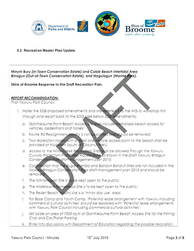
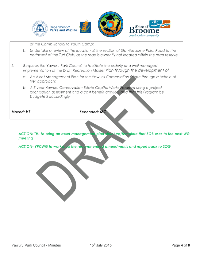
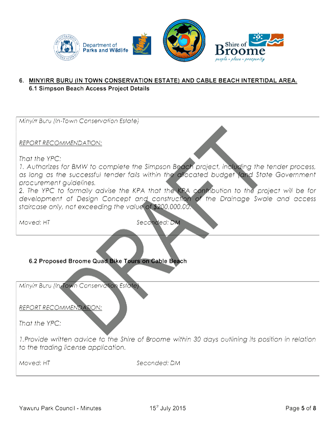

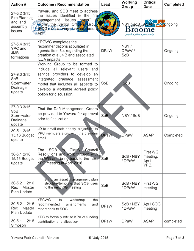

|
Item 10.2 - Yawuru
Park Council Progress Report, 2015 Minutes (March, May and July) and 2016
Minutes (February)
|


11.1 PROPOSED
CLOSURE OF LANEWAY LINKING WING PLACE AND TANG STREET
The following Notice of Motion was
submitted by Cr M Fairborn on 15 July 2016 with Officer Comment by Director
Development Services.
COUNCILLOR
COMMENT / BACKGROUND
There is an
overwhelming public perception within the Broome community of increasing antisocial
and criminal behaviour. The community have called upon all levels of Government
to implement strategies to combat this. As a result, the Broome Shire formed
the Community Safety Working Group, as well as adopting a range of other
methods to help provide increased safety and wellbeing to residents and
visitors. Designing Out Crime Planning Guidelines June 2006, also supports this
philosophy. I believe it is appropriate for the Shire of Broome to adopt these
principles for the benefit of our community.
Background
A number of
residents and home owners of properties in Wing Place have described ongoing
antisocial behaviour and extensive littering in the street and the laneway.
This issue results in private properties being less desirable to purchase or rent
on the public market. It also makes the attraction and retention of tenants
more difficult. Apparently some perspective tenants have left real estate
property viewings before even looking inside the homes due to the state of the
street and laneway. Residents have stated that they would like the laneway
closed.
The
Australian Government, Australian Institute of Criminology have produced a
publication called ‘Effective crime prevention interventions for
implementation by Local Government’. One of the recommendations described
how reduced access to residential areas (such as through laneway gating) showed
evidence of effectiveness in reducing crime and antisocial behaviour. This in
turn would increase desirability for prospective tenants and create a more
positive ethos and neighbourhood culture.
Proposal
That the
laneway linking Wing Place and Tang Street be:
1. Closed immediately;
and
2. A land buy back
scheme be investigated with the intention to offer the owners of the laneway’s
neighbouring properties an opportunity to ‘buy back’ the land of
the laneway.
Financial
The cost to
implement the above would need to be considered, but is not expected to exceed
more than $10,000.00.
|
COUNCILLOR
RECOMMENDATION:
That
the laneway linking Wing Place and Tang Street be:
1. Closed
immediately; and
2. A land buy back
scheme be investigated with the intention to offer the owners of the
laneway’s neighbouring properties an opportunity to ‘buy
back’ the land of the laneway.
|
Attachments
Nil
11.2 ADOPTION
OF CABLE BEACH DEVELOPMENT STRATEGY
The following Notice of Motion was
submitted by Cr E Foy on 20 July 2016 with Officer comment provided by Director
Development Services.
COUNCILLOR COMMENT /
BACKGROUND
A number of residents and home owners
have expressed their concern regarding the Draft Cable Beach Development
Strategy.
This is due to proposed building
height restrictions on Lots 1640 and 2212 Cable Beach
Road West (the former location of the Malcolm Douglas Crocodile Park) to allow
for a five-storey building. Concerns have also been raised in relation
to the clearing of vegetation along Cable Beach West Road.
This type of development will
increase traffic congestion in the area and there are concerns that a lack of
infrastructure exists to service the increase in people and vehicles.
OFFICER Comment
The draft Cable Beach Development
Strategy (draft Strategy) was publicly advertised in accordance with a
Community Engagement Plan endorsed by Council at its April 2016 Ordinary
Meeting. At the close of the advertising period 40 submissions had been
received. Of these submissions, 12 expressed concern about the potential for a
five-storey building, one submitter wished to see further urban design studies
undertaken prior to supporting an increase in building height, and one
submitter wanted the building height allowance to accommodate a taller
building. Five submitters expressed concern about the clearing of
vegetation along Cable Beach Road West. Each of these matters is
addressed below.
Potential for 5 storey building
Local Planning Scheme No. 6 (LPS6)
current limits non-residential building height to a wall height of 10 metres
and an overall height of 14 metres, which is generally equivalent to three
stories. However, Clause 5.4.1 of LPS6 allows the local government to vary any
standard or requirement under the Scheme, ‘unconditionally or subject to
such conditions as the local government thinks fit.’ The draft Strategy
endeavours to guide the local government in terms of where exercising this
discretion may be appropriate.
LPS6 states that the local government
may only exercise its power to vary a Scheme provision if:
(a) Approval of the proposed
development would be appropriate having regard to the criteria set out in
clause 67 of the deemed provisions; and
(b) The non-compliance will not
have any adverse effect upon the occupiers or users of the development, the
inhabitants of the locality or the likely future development of the locality.
The criteria to be considered in
Clause 67 of the deemed provisions include:
(m) the
compatibility of the development with its setting including the relationship of
the development to development on adjoining land or on other land in the
locality including, but not limited to, the likely effect of the height, bulk,
scale, orientation and appearance of the development;
(n) the
amenity of the locality including the following:
(i)
environmental impacts of the development;
(ii) the
character of the locality; and
(iii) social
impacts of the development
This means that if a development
proposal is not consistent with the above (i.e. it is considered incompatible
with the bulk and scale of adjoining development, or it will have adverse
impacts on the environment or the character of the locality) then it will not
be supported.
It should be noted that the draft
Strategy only identifies a single site, the Old Crocodile Park site, as
potentially being suitable for an increase in height to no more than 5
storeys. Whilst the draft Strategy allows for proposals for increased
height at this site to be considered on their merits, it does not commit
Council to a particular course of action. In this way it is considered that
LPS6 already contains adequate controls to prevent inappropriate development.
The vision of the draft Strategy is
for the Cable Beach Tourist Precinct to continue to function as the major
leisure tourism area of the Shire, including tourist accommodation,
restaurants, bars and leisure activities on and around Cable Beach. State and
national guides for tourism planning encourage the provision of incentives, including
‘floor space and height inducements’ to stimulate tourist
development. (WAPC Tourism Planning Guidelines 2014, National Tourism
Planning Guide – A Best Practice Approach 2011). Officers
considered that this incentive is best applied to the Old Crocodile Park site
as it sits at the intersection of the two ‘Priority Active
Frontages,’ Cable Beach Road West and Sanctuary Road, at the main entry
into Cable Beach. Further, it is on the eastern side of Cable Beach Road West
and set back over 300m from the beach, which is considered an adequate distance
to preserve the spacious character of the foreshore and limit environmental
impacts.
Car parking will be assessed as part
of any development application, and it is noted that the draft Strategy
requires car parking for tourist development to be provided on site and
screened from the street which will minimise amenity impacts. On-street parking
will be supported for the commercial uses along ‘Priority Active
Frontages,’ however this must be in the road reserve, and road reserves
along Cable Beach Road West and Sanctuary Road are of sufficient width to
accommodate this. The Shire has further undertaken a District Traffic Study
which assessed the capacity of all major roads in the townsite. Whilst this
Study is still in draft format, the modelling outcomes indicate that all roads
in the Cable Beach Tourist Precinct operate substantially below capacity, with
a vehicle over-capacity-ratio of less than 75% (considered highly functional)
predicted until at least 2051. Therefore, it is considered that the existing
road network in Cable Beach has the capacity to accommodate traffic generated
from any proposed development of the site.
Clearing of vegetation
The draft Strategy does not encourage clearing of vegetation,
however recognises that this will occur if the Yawuru tourism site on the
western side of Cable Beach Road West is developed. Any clearing in excess of 5
hectares in any financial year will require a clearing permit to be obtained
from the Department of Environment Regulation (DER) under the Environmental
Protection (Clearing of Native Vegetation) Regulations 2004.
The draft Strategy further discusses streetscape
enhancements along Cable Beach Road West, as it is envisaged that this road
will ultimately provide a direct linkage between the Cable Beach Precinct and
Chinatown. As the shortest route between the two precincts, this link would
likely become the major thoroughfare across the peninsula, and it is envisaged
that it will cater for cyclists, pedestrians, and public transport as well as
vehicles.
A road of this standard will require
dual use paths on both sides of street, as well as sufficient lighting and
adequate shade trees for pedestrian comfort. Additionally, as Cable Beach Road
West is identified as a ‘Priority Active Frontage’ it is likely
that on-street parking will be required along some sections as development with
active street-level commercial uses occurs. This streetscape improvements will
be required to provide a level of service and amenity that is consistent with a
higher-order road that functions as the entry to a world-class tourist
destination. As Yawuru owns a substantial amount of land with frontage to
Cable Beach Road West, the draft Strategy further recommends working with
Yawuru to incorporate cultural elements into the streetscape. This is
considered to be a positive outcome which will assist in achieving
Council’s vision for the Precinct.
Whilst this is likely to mean that
some vegetation along this street is removed, there is considered to be ample
area where vegetation along the road will remain, such as along Gubinge and
Gantheaume Point Roads.
Summary
The agenda item presented to Council
by Officers at this Ordinary Meeting of Council outlines the public consultation
that has occurred for the draft Strategy and considers the submissions
received. Taking into account the submissions received, it is recommended
in the agenda item that the draft Strategy be adopted by Council subject to
additional minor modifications being made to the text of the draft
Strategy. Overall and taking into account these recommended changes made
in response to submissions, the draft Strategy is considered sound and a good
guide for Council, the community and the development industry in relation to
the future development and improvements in the Cable Beach Tourism Precinct.
|
COUNCILLOR/OFFICER
RECOMMENDATION:
That Council not adopt the Cable
Beach Development Strategy.
|
Attachments
Nil